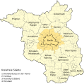
File:Karte Metropolregion Berlin-Brandenburg.svg
外觀

此 SVG 檔案的 PNG 預覽的大小:597 × 600 像素。 其他解析度:239 × 240 像素 | 478 × 480 像素 | 764 × 768 像素 | 1,019 × 1,024 像素 | 2,038 × 2,048 像素 | 829 × 833 像素。
原始檔案 (SVG 檔案,表面大小:829 × 833 像素,檔案大小:327 KB)
檔案歷史
點選日期/時間以檢視該時間的檔案版本。
| 日期/時間 | 縮圖 | 尺寸 | 用戶 | 備註 | |
|---|---|---|---|---|---|
| 目前 | 2020年11月15日 (日) 22:55 |  | 829 × 833(327 KB) | Dingens5 | Kfz-Kennzeichen statt Zahl für kreisfreie Städte |
| 2013年2月27日 (三) 18:21 |  | 829 × 833(322 KB) | NordNordWest | c | |
| 2012年12月16日 (日) 13:19 |  | 829 × 833(495 KB) | NordNordWest | == {{int:filedesc}} == {{Information |Description={{de|1=Metropolregion Berlin-Brandenburg (in hellgelb), engerer Metropolenraum/Kernraum in dunkelgelb}} |Source={{Derived from|Metropolregion-BerlinBrandenburg-Infrastruktur.svg}} * http://gl.berlin-bra... |
檔案用途
下列頁面有用到此檔案:
全域檔案使用狀況
以下其他 wiki 使用了這個檔案:
- de.wikipedia.org 的使用狀況
- Hauptstadtregion Berlin-Brandenburg
- Liste der Hallenkirchen in Deutschland
- Agglomeration Berlin
- Wikipedia:Kartenwerkstatt/Archiv/2012-12
- Wikipedia:Auskunft/Archiv/2017/Woche 30
- Geografie Berlins
- Liste der Bauwerke der norddeutschen und rheinischen Backsteingotik in Deutschland
- Benutzer:Ulamm/Positionskartenlimit
- Benutzer:Z thomas/BB-0
- diq.wikipedia.org 的使用狀況
- es.wikipedia.org 的使用狀況
- frr.wikipedia.org 的使用狀況
- fr.wikipedia.org 的使用狀況
- it.wikipedia.org 的使用狀況
- www.wikidata.org 的使用狀況

