El Hierro: How the youngest Canary Island escaped mass tourism
 Getty Images
While protests against mass tourism rage on neighbouring islands, El Hierro – the wildest and most westerly of the Canary Islands – has quietly chosen to do things very differently.
I had only been hiking for two hours but already I'd passed through a fairy-tale forest of ancient laurels, trunks wrapped in velvety moss and branches dripping with lichen, walked along trails flanked with luxuriant ferns and reached the black ash slopes of a volcanic caldera. Now, before me was yet another scene of jaw-dropping natural beauty: the vast amphitheatre of El Golfo, whose brooding cliffs loomed over a fertile plain and craggy coastline lashed by white-tipped turquoise waves. It was one of the most wild and beautiful places I'd ever seen.
I was in El Hierro, a heart-shaped rock formation off the west coast of Africa that's the youngest, most westerly and second smallest of the Canary Islands. The island emerged from the Atlantic Ocean around 1.2 million years ago following millennia of violent undersea volcanic eruptions, creating a wild landscape of fertile valleys that yield to evergreen forests, sky-high cliffs, volcanic cones and lunar-like badlands.
But what's especially distinctive about this tiny isle is that in a year when protests have raged against mass tourism on neighbouring islands and other regions of Spain, El Hierro has chosen to do things very differently.
El Hierro's population hovers around just 11,000, and its dramatic topography doesn't lend itself to sprawling resorts or skyscrapers. In addition, the island has no direct flights from outside the archipelago, which means it receives only a handful of visitors compared to its neighbours – approximately 20,300 visitors in 2023, while Tenerife, the largest Canary Island, saw more than 6.57 million.
 Getty Images
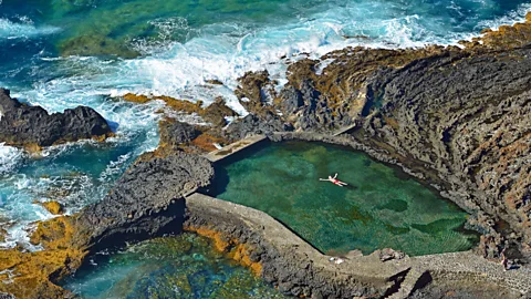
During my visit, I zigzagged up and down vertigo-inducing volcanic stone paths and trekked through forests of soaring Canary pines, fields of fiery red poppies and past plots of pineapples. And I crunched over black lava sprinkled with vivid green succulents then swam in a luminous-blue natural rock pool – all with barely another soul in sight.
El Hierro's aim was always to grow visitor numbers gradually. The forward-thinking island has been committed to a wide-ranging sustainable development plan since 1997, including creating museums and visitor centres (there are seven now) that promote its culture and traditions, focussing on activities with limited environment impact and improving the island's infrastructure while preserving nature (it didn't get its first paved road until 1962 and there's famously only one traffic light).
GREEN GETAWAYS
Green Getaways is a BBC Travel series that helps travellers experience a greener, cleaner approach to getting out and seeing the world.
"We want to increase tourism and continue to improve the island's standard of living, but not to the detriment of the residents' quality of life or the island's natural resources," said Davinia Suárez Armas, island director of tourism and transport. "We prefer to maintain our culture and share our quiet way of life with visitors."
The landscape here changes as quickly as the weather; you can travel from the sun-baked southern coast through barren volcanic badlands and sun-dappled forest, arriving at its diminutive mist-shrouded mountain capital, Valverde, in less than an hour. The island has a multitude of microclimates as well as more than 100 endemic species of flora and fauna, including the critically endangered El Hierro giant lizard, leading Unesco to declare the entire island and a large area of its waters a Biosphere Reserve in 2000 and a Geopark in 2014.
 Getty Images
There are several striking beaches – the black-pebble Timijiraque on the east coast, the red-hued Playa del Verodal on the west, and the white-sand Arenas Blancas at the western tip of El Golfo – but the island is better suited for those who want to get active, rather than fly-and-flop.
WHAT TO DO:
Around 270km of ancient hiking trails crisscross the island, while for aquatic types there's world-class diving in the waters of the Mar de las Calmas Marine Reserve and wild swimming in charcos, natural volcanic rock pools protected from the powerful ocean currents. The island's trade winds are constant enough to guarantee year-round paragliding, with take-off spots at altitudes to suit all levels. The terrain is also perfect for mountain biking, with empty trails meandering along soaring coastal cliffs, through shady forests and down barren volcanic slopes.
Afterwards, explore the island's history and culture with an El Hierro Pasaporte that gives reduced entry to its seven museums and visitor centres.
I took a white-knuckle drive up a series of hair-raising hairpin bends to reach La Dehesa, a windswept high pasture of hardy shrubs, sculptural volcanic stone and El Sabinar, the most famous of a group of ancient juniper trees in the area. A symbol of the island's resilience, their branches swept the ground and the tortured trunks were twisted and bent by centuries of savage trade winds.
Self-sufficiency and sustainability go hand-in-hand with life on a remote isle, and it's been in the islanders' DNA since the first settlers, the Bimbaches, arrived from North Africa around 120 CE. They survived by farming, fishing and foraging, and discovering an ingenious way to collect fresh water – a challenge on an island without rivers or natural lakes.
The tale of the Árbol Garoé, a sacred tree that supplied the Bimbaches with all the water they needed, is rooted in herreño legend, and I discovered how every drop of water counts along the Ruta del Agua (Water Route), a 16km circular trail that begins in El Hierro's highest village, San Andrés.
 El Hierro Tourist Board
The island's history is plagued by devastating droughts that led to mass emigration as far afield as Venezuela, most recently in the mid-20th Century, and this route signposts everything water-related from Los Dornajos (aged wooden water tanks) to dams and divine intervention. The Virgen de los Reyes, the island's patron saint, is said to have ended the drought of 1741, and is celebrated every four years during the Bajada de la Virgen, a month-long, island-wide fiesta.
More like this:
• The Spanish island that communicates by whistle
As I hiked through mist-wreathed pastures to the Árbol Garoé's moss-lined mountain grotto, the ground squelched underfoot, and my clothes and hair became as damp as if it was raining.
"It's a phenomenon known on the island as 'horizontal rain'," explained my guide Enrica Baudino, co-founder of Atlantidea hiking company. "When the moisture-laden north-east trade winds hit the mountains, they are forced to rise, and when they cool, they create a mist that leaves tiny droplets of water on vegetation – and hikers. The Bimbaches built tanks underneath trees and bushes to collect the water."
Get there: Catch a ferry from Los Cristianos in Tenerife or a flight from Tenerife North or Gran Canaria.
Where to stay: Eco-friendly Geko Hotels, a small family-run property in Los Llanillos, is the perfect base for exploring the island.
Where to eat: The popular Guachinche Aguadaraserves grilled meat, island cheeses and local wines. To learn more about the island's one-of-a-kind wine – it has a Denominación de Origen – visit the Casa del Aguardiente in La Frontera.
When to go: Spring and autumn are the best times for hiking, although winters are mild, with temperatures averaging 18C.
At a high point on the route, between Valverde and Tiñor, I looked over Gorona del Viento, El Hierro's pioneering wind-pumped hydropower station. Inaugurated in June 2014 with five 60m-tall wind turbines, two water reservoirs, four hydraulic turbines and one pumping station, it takes advantage of the island's unique topography – combining intermittent wind power with water power to create a constant supply of electricity – to fulfil the island's long-held dream of meeting all its energy needs from renewables.
 El Hierro Tourist Board
Cristina Morales, Gorona del Viento's head of communications, explained how it works: "Surplus wind power pumps desalinated water from a coastal reservoir to the upper reservoir set in a natural volcanic crater 700m above sea level," she said. "When there's no wind, the water is released back to the lower reservoir where the hydraulic turbines generate any electricity shortfall."
And the island is hitting its goals. In August 2015, for the first time, the power station generated all the electricity on the island for four hours and it made history in 2023 when it became the only island in the world to operate solely on wind and water power for 24 consecutive days, saving 13,708 tons of CO2 emissions and 4,509 tons of diesel.
But the wind turbines are spinning less and less in the face of climate change.
"Our production was lower in 2023 because we had a very long summer, with high temperatures and less wind. During September and October, we have a period known as the 'calms of September' – a time of calm seas, pleasant temperatures and little wind. Last year, they lasted almost until January," said Morales. "That's why we are working on implementing other energy sources, such as photovoltaics."
 Getty Images
This innovative island wants to be the first Spanish destination to achieve net zero emissions. "We're developing a climate action plan," Suárez told me. "The aim is to reduce emissions by 50% by 2030, and achieve zero emissions by 2050."
These are big ambitions for such a small isle, but its achievements in sustainability are being recognised. Gorona del Viento has long been a role model for renewable energy projects around the globe, and in September this year, El Hierro will be presented with the Canary Islands Tourism award for Sustainable Tourism Destination, thanks in part to its long-standing environmental policies.
CARBON COUNT
The travel emissions it took to report this story were 0 metric tons of CO2e. Find out more about how we calculated this figure here.
"We want to continue to be pioneers," said Suárez, "not just in the Canary Islands but around the world."
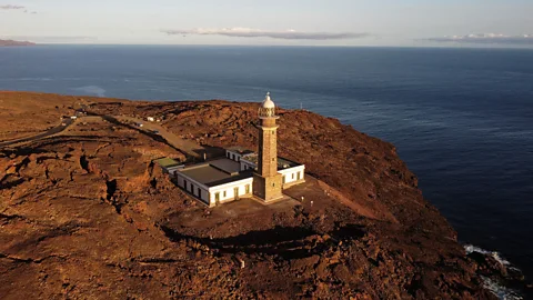
That evening, I headed to Faro de Orchilla, a clifftop lighthouse ringed by rippling red-hued lava, and looked out onto the vast ocean. In the 2nd Century, Greek mathematician and astronomer Ptolemy put El Hierro on the map after declaring that the prime meridian was here at Orchilla, the westernmost point of the island that was – before Columbus set sail in 1492 – the limit of the known world. Longitude zero may have moved to Greenwich in 1884, but as I watched the setting sun streak the water pink and gold, I knew that El Hierro would never lose its wild, edge-of-the-world feel.
--
If you liked this story, sign up for The Essential List newsletter – a handpicked selection of features, videos and can't-miss news, delivered to your inbox twice a week.
