Category:Maps about the history of Tarn-et-Garonne
Jump to navigation
Jump to search
Media in category "Maps about the history of Tarn-et-Garonne"
The following 8 files are in this category, out of 8 total.
-
Arrondiment de Moissac (1808).svg 1,000 × 692; 96 KB
-
Arrondiment de Montalban (1808).svg 1,000 × 692; 146 KB
-
Arrondiment dels Sarrasins (1808).svg 1,000 × 692; 100 KB
-
Arrondiment dels Sarrasins (1926).svg 1,000 × 692; 121 KB
-
Cartes departement origine 1808.pdf 2,481 × 1,754; 1,003 KB
-
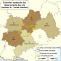
Tarn-et-Garonne department evolution map-de.svg 500 × 500; 500 KB
-
Tarn-et-Garonne department evolution map-fr.svg 500 × 500; 241 KB


