 Cheikh Omar Tidjani Cisse1*
 Emmanuel K. Brempong2,3,4
 Adélaïde Taveneau4
 Rafael Almar4Boubou Aldiouma Sy1
 Donatus Bapentire Angnuureng2
- 1Laboratory Leïdi “Dynamics of the Territories and Development” Department of Geography, University Gaston Berger, Saint-Louis, Senegal
- 2Africa Centre of Excellence in Coastal Resilience, Centre for Coastal Management, School of Biological Sciences (SBS), University of Cape Coast, Cape Coast, Ghana
- 3Department of Fisheries and Aquatic Sciences (DFAS), University of Cape Coast, Cape Coast, Ghana
- 4Laboratory of Geophysical and Oceanographic Spatial Studies (LEGOS), University of Toulouse/CNRS/IRD/CNES), Toulouse, France
In a context of global warming characterized by a mean sea level rise and extreme meteorological events, the study of the causes for coastal flooding is essential to protect communities and ecosystems. Densely urbanized, and rather unprotected cities in developing countries such as the historic Saint Louis city in Senegal are particularly vulnerable to coastal flooding and sea hazards. From satellite-derived high resolution DEM and global ocean reanalyses, here we quantify the extreme coastal water level in order to identify the neighborhoods and places of particular socio-economical interest of Saint-Louis potentially vulnerable to flooding. The results reveal that the most severe levels have the potential to flood up to almost half of this low-lying river mouth plain. Social, economic and heritage stakes are exposed, and the artisanal fisherman district of Gueth Ndar, is particularly vulnerable to coastal flooding because of its low elevation and situation on the sand barrier. The co-occurrence of high tides and wave-induced runup contributes most to ECWL but they do not present a significant trend over the study period. The results show that over the period 1994-2015, potential flood risk increased by nearly one day per year, primarily due to sea level rise, sounding a warning signal to take countermeasures to protect communities and infrastructure.
Introduction
In a global context marked by global warming leading to an increasing rise in sea level, coastal areas are increasingly threatened by the risks of erosion and coastal flooding (Woodruff and Stults, 2016; Kulp and Strauss, 2019; Almar et al., 2021; Kirezci et al., 2020). Coastal areas are among the most vulnerable ecosystems and will be gradually exposed to the effects of climate change over the course of the century (IPCC report, Oppenheimer et al., 2019). According to recent studies, for instance in Almar et al. (2021), the IPCC RCP8.5 scenario would give 50x increase in coastal overtopping by 2100, worldwide. These hazards occur when strong winds and low atmospheric pressure act on the sea surface to cause a temporary rise in sea level (Wells, 2011; Prime et al., 2016), becoming a real environmental concern for anthropized coastlines (e.g. Le Roy et al., 2015). Knowing that more than 600 million people reside in the low elevation coastal zone (<10 m, Ganguli and Merz, 2020), that the coastal activities expose the population to floods and storms (Dupuis, 2016) and that 3/4 of the world’s largest cities are located on those vulnerable areas (Melet et al., 2018), the combination of current massive urban growth and climate change impacts exposes coastal cities to increased and unprecedented coastal risks and environmental issues (Cain et al., 2015; Bongarts Lebbe et al., 2021). Whether riverine or coastal, flooding is one of the most devastating coastal hazards in the world, causing numerous deaths and significant socio-economic consequences each year (Kupfer et al., 2022). According to Vousdoukas et al. (2016), coastal flooding will increase in the context of future storm variability and sea level rise. Nowadays, flooding represent one of the most important issues facing coastal communities (Woodruff et al., 2013).
On the Atlantic coast of Central and West Africa, coastal flooding is one of the greatest threats to the socio-economic and environmental balances of countries south of the Sahara (Tchindjang et al., 2019; Alves et al., 2020; Dada et al., 2021; Vousdoukas et al., 2022). Most West African major cities are exposed to flooding there, and current forecasts show that sub-Saharan Africa and the low elevation, flat deltaic and island coastal regions are among the most affected areas by climate change (Gemenne et al., 2017; Giardino et al., 2018). Extreme Coastal Water Level (ECWL) at the coast results from the combination of several different coastal processes (Eq. 1); the regional sea level anomaly (here referred to as SLA) due to the steric effect, ocean circulation and transfer of mass from the continents (ice sheets, glaciers, land water) to the ocean, storm surge or “Dynamic Atmospheric Correction” (DAC) due to atmospheric pressure and winds, astronomical tide (T) and wave effects here referred to as runup (R) which includes a time-averaged component (setup) and an oscillatory component (swash) (see Melet et al., 2018; Dodet et al., 2019; Almar et al., 2021).
The West Africa coast is generally considered a storm-free environment, dominated by North Atlantic distant swells (Sadio, 2017; Almar et al., 2019; Ndour et al., 2020). The evolution of the sandy coast is controlled by strong longshore sediment drift resulting from oblique waves (Laïbi et al., 2014; Almar et al., 2015; Giardino et al., 2018; Almar et al., 2019; Anthony et al., 2019). Tidal amplitude is typically micro to meso at open stretches of coasts, with the highest amplitudes recorded in deltas and estuaries of Guinea, Guinea-Bissau and Sierra Leone (2.8 - 4.7 m; Diop et al., 2014). Senegalese urban coastal areas, which are low elevated and made of loose or low-strength materials (Weissenberger et al., 2016; Ndour et al., 2018; Ndour et al., 2020) often lying on barrier and at delta, are particularly exposed to marine flooding, which has severe consequences on coastal development (Quiroga et al., 2021). Located at the mouth of the Senegal River, Saint-Louis has a mixed environmental problem with respect to flooding, affected by both coastal flooding and river flooding (Sall, 2006; Wade et al., 2008; Ndour et al., 2018). Although this situation is well known in the history of this city, the situation recently worsened (Durand et al., 2010; Sadio, 2017; Bergsma et al., 2020) due to the rising sea level together with the increase in ocean influence induced by a breach made in the Langue de Barbarie in 2003, a coastal spit that previously protected the city from the Atlantic. When large storm surges occur during rainy periods, when the agitation of the sea hinders the evacuation of river water (Sadio et al. 2017), large-scale events can occur, including those of August 2017 and February 2018, which caused the destruction of 100 houses and the displacement of 2600 people (Diagne, 2020).
In the context of ongoing climate change and the prediction of an increase in climatic instability, the extension of flood-prone areas, in relation to a given climatic hazard, is a scientific concern with strong societal implications (Breilh et al., 2012), but in Senegal, there is almost non- existent work on marine flooding and the anticipation of their impact and mitigation/adaptation (Cisse et al., 2022). In addition, given the gradual artificialization of Saint-Louis coastline, which is reflected in the emergence of numerous coastal protection projects (Alves et al., 2020) such as a riprap built between 2020 and 2022 it is of the essence to study coastal flooding. According to Tebaldi et al. (2012) understanding coastal flooding vulnerability is essential to the decision-making logic and to the protection policies of coastal communities and assets.
Using satellite-derived data and model hindcast data, this paper aims to evidence the vulnerability of the historic Saint-Louis city to potential coastal flooding where it endangers property and people, economic activities, and cultural and religious heritage.
Study area
The city of Saint-Louis is located in northern Senegal (Figure 1). It has the characteristics of an amphibious city, as it is built partly on the mainland, partly on an island in the Senegal River and partly on the Langue de Barbarie (Sall, 2006). The latter is a sandy coastal spit that extends for 40 km and has a variable width of about 100 m. Bounded by the Atlantic Ocean to the west and the Senegal River to the east, the Langue de Barbarie forms an elongated peninsula running north-south (Kante and Fall, 2019; Brüning, 2022). It is a highly urbanized site with the presence of human settlements, artisanal landing ports, tourist facilities, and a national park of high environmental value. Indeed, like other sections of the Senegalese coastline, the Saint-Louis coastline is among the most vulnerable to flooding and erosion risks. It has a flat topography (most neighborhoods are built less than 2 m above sea level), sandy soil, and a site dominated by water, which exposes the population to many natural hazards, the most recurrent of which are floods (Durand et al., 2010; Sy et al., 2011).

Figure 1 Location of the study area and satellite images acquisition. (Left) Pleaides satellite (CNES/Airbus) tri-stereo acquisition (made using Google Earth). (Right) North-oriented Pleiades satellite image of Saint Louis city.
Materials and methods
Topographic data
The Digital Elevation Model (DEM) used in this study is derived from the very high- resolution optical imagery from Pleiades satellite (CNES/Airbus) - see Figure 1. Using Pleiades panchromatic image (0.5 m ground pixel resolution), a tri-stereogrammetry method is performed using the NASA software ASP (Ames Stereo Pipeline; Shean et al., 2016) to extract the topography of the Langue de Barbarie (Almeida et al., 2019; Salameh et al., 2019; Taveneau et al., 2021). The use of tri-stereo method (three images) is preferred over stereo one (two images) as it significantly improves the derived-topography (Almeida et al., 2018; Collin et al., 2018; Taveneau et al., 2021; James et al., 2022). The images selected for this work are 3 acquired in March 2019, and further processed using the method further described by Taveneau et al., 2021. The obtained DEM has a 2 m ground pixel resolution and is map-projected into the UTM 28 coordinates system thanks to the RPC (Rational Polynomial Coefficient) geometric file provided with each Pleiades product.
This satellite-derived DEM-generation method allows a good relative map-projection of the data, but the vertical values “float” in absolute as no elevation information is provided within ASP. Ground control points are essential to give reference points to the DEM and correct the offset. With ground surveys carried out few days apart from the satellite acquisition using a RTK-GPS (Real Time Kinematic - Global Positioning System) with a centimetric-precision (performed by the SHOM, the French Navy Hydrographic and Oceanographic Service) over 13 km of the Langue de Barbarie), the DEM elevation is vertically-corrected (Garlan et al., 2020) thanks to the collected ground control points. Overall, although it depends on the nature of the ground (e.g., buildings, flat terrain, vegetation), sub-metric to metric accuracy is obtained from Pleaides mission-derived DEMs after offset correction (Almeida et al., 2019; Taveneau et al., 2021).
Hydrodynamic data
Quantification of extreme coastal water levels requires the availability of hydrodynamic, meteorological and tidal parameters. Tide data are extracted from the global tide FES2014 model (Finite Element Solution, Carrere et al., 2016) at hourly resolution and gridded worldwide at a 1/16° resolution and produced by Laboratory of Geophysical and Oceanographic Spatial Studies of Toulouse (LEGOS). Atmospheric pressure and winds component (DAC) is produced by the Collecte Localisation Satellites (CLS) Space Oceanography Division using the MOG2D model from LEGOS and distributed by AVISO (Archiving, Validation and Interpretation of Satellite Oceanographic data), with support from Centre National d’Etudes Spatiales (CNES) (http://www.aviso.altimetry.fr/). Altimetric-derived SLA, including global mean level rise, is extracted at the closest altimetry gridded data point from AVISO and it corresponds to offshore regional sea level (Marti et al., 2021). ERA-Interim reanalysis data (global climate and weather data available from 1979 onward) at a 0.5° x 0.5° resolution developed by the European Center for Medium-Range Weather Forecasting (ECMWF) model are used for waves data at a 6-hour resolution over the 1994-2015 period. Wave runup R is computed following the dissipative beach form of Stockdon et al., 2006 (see Almar et al., 2021):
Where Hs and Lo are offshore significant wave height and wavelength. All the above-mentioned parameters are resampled on an hourly basis over the 2013-2015 period. All the hydrodynamic data used in this study are global dataset available worldwide are all extracted at the nearest point from Saint Louis city (latitude 16.23°, longitude -16.21°) in the corresponding grids, which ensures here a maximum distance of 50 km from the coarsest grid. They correspond to off the coast forcing and does not reflect local coastal complex processes that might occur (i.e. interactions between drivers, waves refraction, morphology changes – see Idier et al., 2019; Bergsma et al., 2022).
Quantification of the extreme coastal water level
To quantify the extreme coastal water level at Saint-Louis, we use the formula of Almar et al. (2021) (Eq. 1):
The extreme levels are generated following the combination of several parameters, this model incorporates the sea level anomaly (SLA), the height of the storm surge (DAC) due to atmospheric pressure and winds, the level of the astronomical tide (T) and the height of wave breaking (R). In order to physically determine the impact of extreme water level reached by the sea in Saint-Louis, we define the severe water levels corresponding to the top 2%, thus the 98th percentile (following a common definition of extreme storms). The cumulative annual occurrence of the of the time spent over this threshold is computed over the study period.
To compute overtopping and flooding potential, the topographic data in this work are set to a geoidal coordinate system (vertical datum). Here, the ECWL are converted to geodetic data using the vertical datum value (0.981m) of Wöppelmann et al. (2008), so that they can be superimposed with the topographic data. It should be recalled that the vertical datum used is that of the tide gauge in Dakar, because there is no one in Saint-Louis.
To study the trend of evolution of the extremes in Saint-Louis on the basis of annualized data, the regress function of the Matlab software (linear regression) is used. In addition, the statistical test p-value is calculated to determine the level of significance of the trend.
Flood zone and mapping and risk for infrastructures
The methodological approach to flood mapping adopted in this work is based on the calculation of the percentage of potentially floodable surface through the satellite-derived DEM and the raster calculator tool of the Arc Gis software. Then, from the OSM (Open Street Map) databases, the properties (buildings, parcels, etc.) are vectorized in Arc Gis. To identify the infrastructures potentially exposed to flooding, spatial queries similar to the selection by location are made in order to extract the properties that are under the spatial extension of a certain ECWL threshold.
Results
Evolution of extreme coastal level occurrences
The thresholds representing the percentiles of low (30%), moderate (60%) and severe (98%) ECWL correspond to -0.05 m, 0.78 m and 1.98 m, respectively (Figure 2A). Figure 2B shows the evolution of the most severe threshold that presents a strong interannual variability. The maximum temporal occurrence of the 1.98 m level was 180 hours between 1995 and 2000, but since 2005, there are 3 years out of 5 where it does not exceed 100 h, with a minimum value of 54h. By extension, the occurrence of floods has weakened over the sequence 2005-2010. On the other hand, from 2010, there is an increase in the frequency of flooding, with a maximum value of 220h, which reflects an increase in the total annual duration of extreme sea levels, and probably the frequency of coastal flooding in Saint-Louis. Overall, the increasing trend in occurrence (significant at 95% level) is 1h per year which correspond to almost a day spent with flooding over this 23 years period.

Figure 2 (A) Distribution of different percentiles of extreme coastal water level (ECWL), from 1994 to 2015. (B) Number of hours per year that coastal sea level at Saint-Louis reaches the 98th percentile (1.98 m).
Flood-prone areas and associated impacts
To show the potential of extension of the coastal flooding in Saint-Louis, a mapping of flood-prone areas is performed based on the two highest percentiles, 60th and 98th, combined with satellite-based DEM (Figure 3). This because the 30th (-0.05 m) percentile does not generate any risk of flooding in Saint-Louis.

Figure 3 Spatial extent (red) of potential flooding for the moderate and severe ECWL scenarios, i.e. the 60th and 98th percentile.
Figure 3 shows a significant variation in the extent of flooding between the 60th and 98th percentiles and highlights a spatial contrast of the Saint-Louis coastline sections submerged by extreme water-levels. The used-approach reveals that 10% of the Saint Louis area would be potentially flooded under the 60th ECWL threshold, in this low-lying river mouth alluvial plain. This surface potentially submerged under the severe 98th ECWL threshold reaches 45% of the area is floodable, reaching key urbanized areas.
The results reveal that some neighborhoods of Saint-Louis are potentially exposed to extreme coastal water levels. Indeed, much of the area covered by the Langue de Barbarie is submersible. Figure 4 shows that the district of Gueth Ndar (the most densely populated of Saint Louis and Senegal; Diop, 2017) is the most exposed to coastal flooding, followed by Ndar Toute and Goxxu Mbacc. On the other hand, important governmental infrastructures located on the island of Saint-Louis appears to be preserved: the spatial extent of the severe water level (98th percentile) does not affect this part of Saint-Louis (north and south island). Moreover, the spatial disparity of the flood extension observed on the Langue de Barbarie is similar to that observed in the Sor suburb. In this part of Saint-Louis, only the neighborhoods located in front of the Senegal River are subject to flooding and the Pikine neighborhood located inside the Sor suburb. From the 10 sites (Goxxu Mbacc, Ndiolloféne, Gueth Ndar, North and South Islands, Corniche, Balacos, Diamaguene, Léona and Pikine), Gueth Ndar remains the most vulnerable to coastal flooding. This is explained by its elevation characteristics largely below the hydrodynamic extreme levels (i.e. 1.98 m). In terms of infrastructure, the spatial queries performed reveal that 140 of the 24588 buildings and 452 plots of land (or parcels) on 13796 can be flooded. This means that many social, economic, cultural and religious assets are potentially endangered if not protection is deployed.
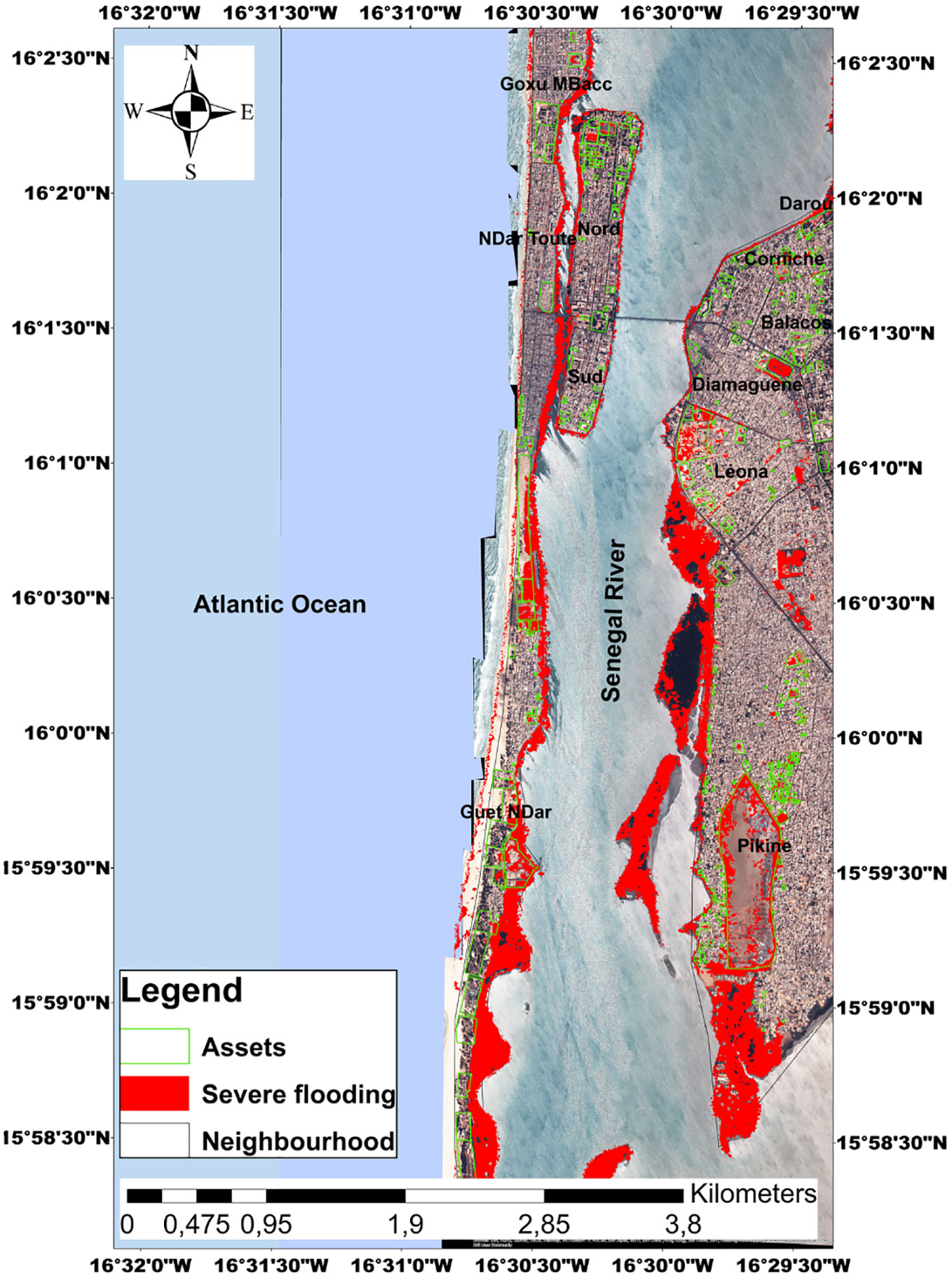
Figure 4 Map of infrastructures and assets of Saint Louis likely to be potentially flooded under the 98th ECWL percentile (i.e. 1.98 m).
Hydrodynamic factors contributing to coastal flooding
Since the estimation of EWCL from the Almar et al. (2021) model involves four parameters, we estimate here the relative weight of each of them in the 98th percentile for the period 1994-2015. Figures 5A–E shows hourly overall timeseries and annual means of each component. Figure 5F shows the aggregated annual conditions that produced a level above the 98th percentile. The tide (T) contributes the most with 71%, followed by wave run-up (R) with 25%, sea level anomaly (SLA) drives 3%, with a negligible contribution (<1%) of storm surge height due to atmospheric pressure and winds (DAC) in this storm free environment. Noteworthy, while SLA and DAC are dominated by interannual low varying evolutions (i.e. season to years), waves and particularly tide have rapid changes (i.e. hours to days).

Figure 5 (A–E) ECWL components hourly (black) and yearly (red) timeseries and (F) contribution of each ECWL component passing the 98 percentile and potentially causing severe flooding in Saint-Louis between 1994 and 2015. In (F) the components are aggregated yearly during the moments overpassing the 98 percentile. Blue line in (E) stands for the 98th percentile of the ECWL timeseries, and referred to as “severe” value.
The analysis of the evolution of the extreme level of coastal waters in Saint-Louis reveals that despite his minor influence on ECWL events, only SLA shows a significant 3.5 mm/yr trend at the 95% level (pvalue less than 0.05), which contributes to the increase in potential flooding. However, the large variability of wave runup T and R during the events prevent a robust overall trend assessment of ECWL on the study period and is a clear source of uncertainty for coastal flooding risk prediction in Saint Louis and elsewhere. This is due to the combined effect of their large amplitude with high frequency signal with a random phasing: waves randomly reach the coast during neap or spring tides, low or high tides.
Discussion
The estimation of the extreme coastal water level in Saint-Louis reveals that this section of the Senegalese coastline is extremely vulnerable to ocean-induced flooding. Being a highly urbanized site with an urban growth of 5% (Sidibe, 2013), there is no doubt that the shores are highly exposed to coastal flooding. Therefore we cannot talk about risk or vulnerability without the existence of stakes (Pont, 2015): socio-economic or environmental. The potential flood events of the Langue de Barbarie are likely to affect social, cultural, economic, heritage and cultural matters. Flooding in Saint-Louis causes a wide range of impacts (Sall, 2006). From a spatial point of view, the potential impacts manifest themselves in variable geometry. Of the 10 sites (Goxxu Mbacc, Ndiolloféne, Gueth Ndar, North and South Islands, Corniche, Balacos, Diamaguene, Léona and Pikine), the site of Gueth Ndar remains the most vulnerable to coastal flooding. The district of Gueth Ndar is the most exposed to flooding likely to be induced by the 1.98m water level. Given its high human density, it is the most populated neighborhood of the Saint Louis, but also of Senegal and West Africa (Diop, 2017; Brüning, 2022). This high human concentration combined with its sensitivity to flooding, makes it particularly vulnerable. Many of the social assets (including historical cemetery) present in this part of the Langue de Barbarie would be impacted by flooding, which would also have consequences for the population as well as for socio-economic activities, particularly fishing, which is the dominant activity. This situation of vulnerability should incite decision makers and coastal managers to consider the protection of this section of the Saint-Louis coastline. Efforts concerning the protection of coastal communities of the Langue de Barbarie have been made through the construction of a protective dyke of 3m height in 2022. However, beyond the hard methods of coastal protection, other alternatives of protection should be adopted such as soft and nature based solutions (Alves et al., 2020). Indeed, our results show that more and more extreme coastal water levels are expected and could overtop and overflow the protective dike. To this end, the use of soft development measures would be an effective solution. Soft solutions are less damaging to the environment than hard solutions (Schoones et al., 2019). Moreover, Baldé et al. (2021) showed that beach nourishment in the Langue de Barbarie, in this case the beaches of Pilote Bar, played an important role in that it contributed to beach widening. This method can also be efficient in dealing with coastal flooding. A wide, fattened beach provides good protection against erosion and overwash by decreasing runup propagation, as well as the probability of crossing (Duvat, 2001; Balouin et al., 2012; Itzkin et al., 2021). Moreover, it is likely to encounter the phenomena of land subsidence of this densely populated Gueth Ndar neighborhood. Continued subsidence catalyzes sea level rise, which in turn increases water levels, which exacerbates coastal flooding (Moller et al., 2014). According to Woodruff et al. (2013), the impacts of coastal flooding can be mitigated in part through the implementation of adaptation strategies using conservative sediment management and human-induced subsidence reduction. The protection of this sandy strip (Langue de Barbarie) is of paramount importance, as its disappearance could have significant impacts on the city of Saint-Louis and the Sor suburb. In fine, the relocation of populations may be a possible solution to protect people. Moreover, a relocation project to offer long-term protection to the populations of the Langue of Barbarie in Saint-Louis is underway. A 14-hectare relocation site located in Diougop outside the city of Saint-Louis is being developed. On this site, 600 housing units will be built to accommodate 10,000 people (Brüning, 2022). This relocation project is currently encountering a number of pitfalls related to the issue of social acceptability. The populations of Gueth Ndar, who are mostly fishermen, feel that this policy of relocation inland would take them away from their place of work, the sea. However, a participatory approach should be adopted to facilitate acceptance of the project if their cultural and socio-economic contribution to the identity of Saint-Louis is to be maintained.
Given that the drivers of coastal flooding are varied (Prime et al., 2016), we attempted to separately analyze the factors contributing to coastal flooding in Saint-Louis. Our results show that the tide is the dominant driver of coastal flooding in Saint-Louis. This observation is also made by Durand et al. (2010) on the Langue de Barbarie. This finding is consistent with Almeida et al. (2018) and Dada et al. (2019) works showing at other low-lying coasts exposed to energetic waves that coastal flooding in Nha Trang (Vietnam) and low-lying mud coast in Nigeria Delta (Gulf of Guinea) are due to the interaction between waves and tide. Durand et al. (2010) also points out that the tidal range has significantly increased after the opening in 2003 of a breach in the sandspit and water levels in Saint-Louis lagoon are increasingly aligned with the rhythm of the tides. However, due to the lack of long-term tide gauges in Saint Louis, more generally along the African coast (Abessolo Ondoa et al., 2019; Marti et al., 2021; Almar et al., 2022), our current study is limited by the use of the FES2014 tide data which are harmonic-based, off-shore, and do not reflect change over time (Figure 5D); any trends or changes in local tides in could not be determined. Our results also show interannual variability in the temporal occurrence of extreme water levels at Saint-Louis. Especially since our results reveal that the tide is the main factor contributing to coastal flooding in Saint- Louis, and that in a global context of global warming the sea level is expected to increase. Thus, the impact of flooding in Saint-Louis will strongly impact coastal communities. Due to the presence of the river, the study area is at great risk of flooding as the sea level rises gradually. Sea level rise by 2100 will strengthen coastal flooding in Saint-Louis (Sall, 2006). Our data reveal that waves have a significant impact on the occurrence of ECWL events at Saint-Louis. As a difference with tides, the action of waves on extreme events is likely to take significant proportions especially in a context of climate and climate variability change, it should be remembered. In particular, waves have a strong interannual fluctuation controlled by the North Atlantic Oscillation (Almar et al., 2019). Climate change, - which is reflected in the sea level rise, has the effect of strengthening the action of waves (Costa, 1995; Wang et al., 2003; Melet et al., 2018), and will influence the generation of swells of high intensity at the coast (Sergent et al., 2010; Vitousek et al., 2017). This concern is confirmed by the global simulations of Vitousek et al. (2017) that identify the inter-tropical zone as particularly exposed to future increase in coastal flooding.
In St. Louis, we find that this increase in potentially inundated area with ECWL is rather linear (Table 1). Interestingly, while there is considerable climate-induced variability in waves, model predictions do not indicate clear long-term trends (Melet et al., 2020a), nor does the R runup. While current ECWL maxima are about 2 m, with a 1 m sea level rise offset, as predicted (Oppenheimer et al., 2019) for the late 21st century, the inundated area can be expected to increase by 25% if no protective measures are taken.

Table 1 Potential flooded area (%) at Saint Louis for ECWL thresholds.
Lastly, it should be noted that when interpreting the consequences of overtopping on coastal flooding, the occurrence of overtopping does not necessarily imply that the entire low elevation coastal zone is flooded. Rather, overtopping drives localized coastal flooding, immediately adjacent to areas of overtopping, which would likely be both temporally and spatially variable due to the combined effects of temporal and alongshore gradients in breaking wave heights, and alongshore variations in coastal elevation maxima (Almar et al., 2021). Even if a standalone use for coastal studies (e.g. without ground control point) is not yet conceivable at this stage with operational accuracy (Taveneau et al., 2021; Turner et al., 2021), considering the encountered accuracy limitations, satellite-based topography monitoring appears as a breakthrough in decade-old monitoring technological barriers (Benveniste et al., 2019; Melet et al., 2020b), in support of coastal engineering.
Conclusion
By combining satellite-derived DEM with reanalyzes and satellite observations of sea level components, this paper assessed the vulnerability of the Saint-Louis coastline to the potential risk of coastal flooding. Testimonies already reported various impacts on economic, cultural, patrimonial and infrastructural. Our results confirm that this site is extremely vulnerable to coastal flooding potential almost half of this low lying river mouth plain flooded under severe water levels. Spatially, the different neighborhoods of Saint-Louis are unequally affected with the most exposed one, also one of the poorest with vulnerable communities, being located on the Langue of Barbarie sandspit. Sea level rise is the main factor for the trend. However, the fact that on top of rising sea, that the compound influence of waves and tide that is predominant responsible for the events induce a large uncertainty on the prediction of coastal risk. This study documents coastal risk flooding potential and its drivers which is not sufficiently quantified and understood on the Senegalese coasts and West Africa, and whose knowledge is an essential element in the elaboration of coastal development schemes and protection of coastal communities.
Data availability statement
The original contributions presented in the study are included in the article/supplementary material. Further inquiries can be directed to the corresponding author.
Author contributions
All authors contributed to the article and approved the submitted version.
Funding
This article was produced with the support of coastal protection project in Saint-Louis (PPCS) co-financed by French Agency for Development/Municipal Development Agency. Convention n°CSN156102.
Acknowledgments
The authors would want to thank the Senegalese Agence of Development Municipal (ADM), the French Agency Development (AFD) for funding this research and the program DINAMIS for making the satellite Pleiades data available.
Conflict of interest
The authors declare that the research was conducted in the absence of any commercial or financial relationships that could be construed as a potential conflict of interest.
Publisher’s note
All claims expressed in this article are solely those of the authors and do not necessarily represent those of their affiliated organizations, or those of the publisher, the editors and the reviewers. Any product that may be evaluated in this article, or claim that may be made by its manufacturer, is not guaranteed or endorsed by the publisher.
References
Abessolo Ondoa G., Almar R., Castelle B., Testut L., Léger F., Sohou Z., et al. (2019). Sea Level at the coast from video-sensed waves: Comparison to tidal gauges and satellite altimetry. J. Atmospheric Oceanic Technol. 36 (8), 1591–1603. doi: 10.1175/JTECH-D-18-0203.1
Almar R., Kestenare E., Reyns J., Jouanno J., Anthony E. J., Laibi R., et al. (2015). Response of the bight of Benin (Gulf of Guinea, West Africa) coastline to anthropogenic and natural forcing, Part1: Wave climate variability and impacts on the longshore sediment transport. Continental Shelf Res. 110, 48–59.
Almar R., Kestenare E., Boucharel J. (2019). On the key influence of remote climate variability from tropical cyclones, north and south Atlantic mid-latitude storms on the Senegalese coast (West Africa). Environ. Res. Commun. 1 (7), 071001. doi: 10.1088/2515-7620/ab2ec6
Almar R., Ranasinghe R., Bergsma E. ,. W. J., Diaz H., Melet A., Papa F., et al. (2021). A global analysis of extreme coastal water levels with implications for potential coastal overtopping. Nat. communication 12, 3775. doi: 10.1038/s41467-021-24008-9
Almar R., Stieglitz T., Addo K. A., Ba K., Ondoa G. A., Bergsma E. W., et al. (2022). Coastal zone changes in West Africa: challenges and opportunities for satellite earth observations. Surveys Geophysics, 1–27. doi: 10.1007/s10712-022-09721-4
Almeida L. P., Almar R., Bergsma E. W., Berthier E., Baptista P., Garel E., et al. (2019). Deriving high spatial-resolution coastal topography from sub-meter satellite stereo imagery. Remote Sens. 11 (5), 590. doi: 10.3390/rs11050590
Almeida L. P., Almar R., Meyssignac B., Viet N. T. (2018). Contributions to coastal flooding events in southeast of Vietnam and their link with global mean sea level rise. Geosciences 8, 437. doi: 10.3390/geosciences8120437
Alves B., Angnuureng D. B., Morand P., Almar R. (2020). A review on coastal erosion and flooding risks and best management practices in West Africa: what has been done and should be done. J. Coast. Conserv. 24 (3), 1–22. doi: 10.1007/s11852-020-00755-7
Anthony E. J., Besset M., Dussouillez P., Goichot M., Loisel H. (2019). Overview of the moonsoon-influenced ayeyarwady river delta, and delta shoreline mobility in response to changing fluvial sediment supply. Mar. Geology 417, 106038. doi: 10.1016/j.margeo.2019.106038
Baldé O., Sakho I., Diouf M. ,. B., Bop M., Tine D., Ibouroi W. (2021). Effectiveness of pilote bar (St. Louis) beach nourishment after a decade of erosion. Eur. Sci. J. 1710, 207–231.
Balouin Y., Belon R., Stépanian A., Bodéré G. (2012). General study for the protection of the coastline of the eastern plain of Corsica: management recommendations. Rapport BRGM/ RP 61650-FR, 52.
Benveniste J., Cazenave A., Vignudelli S., Fenoglio-Marc L., Shah R., Almar R., et al. (2019). Requirements for a coastal hazards observing system. Front. Mar. Sci. 6, 348. doi: 10.3389/fmars.2019.00348
Bergsma E. W., Almar R., Anthony E. J., Garlan T., Kestenare E. (2022). Wave variability along the world’s continental shelves and coasts: Monitoring opportunities from satellite earth observation. Adv. Space Res. 69 (9), 3236–3244. doi: 10.1016/j.asr.2022.02.047
Bergsma E. W., Sadio M., Sakho I., Almar R., Garlan T., Gosselin M., et al. (2020). Sand-spit evolution and inlet dynamics derived from space-borne optical imagery: Is the Senegal-river inlet closing? J. Coast. Res. 95 (SI), 372–376. doi: 10.2112/SI95-072.1
Bongarts Lebbe T., Rey-Valette H., Chaumillon É., Camus G., Almar R., Cazenave A., et al. (2021). Designing coastal adaptation strategies to tackle sea level rise. Front. Mar. Sci. 1640.
Breilh J. F., Chaumillon E., Bertin J. (2012). “Improve of a static flooding method and application to the case of the xynthia storm,” in XIIth National Conference on Coastal Engineering, Cherbourg (Nantes, France: Paralia). doi: 10.5150/jngcgc.2012.100-B
Brüning L. (2022). Erosion côtière au nord du sénégal: migrations et stratégies d’adaptation (these de géographie, instiut: Institut de Géographie, Université de Neuchâtel).
Cain A., Cisse O., Abdrabo M., Sah Akwen N. (2015). Climate-responsive planning for angola's coastal cities. Dev. Workshop, 4.
Carrere L., Lyard F. H., Cancet M., Guillot A. (2016). “Finite element solution FES2014, a new tidal model – validation results and perspectives for improvements,” in ESA Living Planet Conference (Paris, France: European Space Agency).
Cisse C. O. T., Sagne P., Ba K., Fall B., Sy B. A., Marone A. (2022). Modelling of extreme water levels on Malibu, gadaye and malika sandy beaches (Dakar, Senegal) following the 19 November. Eur. Sci. J. 18 (3), 80–100. doi: 10.19044/esj.2022.v18n3p79
Collin A., Hench J. L., Pastol Y., Planes S., Thiault L., Schmitt R. J., et al. (2018). High resolution topobathymetry using a Pleiades-1 triplet: Moorea island in 3D. Remote Sens. Environ. 208, 109–119. doi: 10.1016/j.rse.2018.02.015
Costa S. (1995). “Sea Level rise and response strategies: the case of the Normandy-picardy coastline,” in Annales de géographie 107, n°600edition, 179–200.
Dada O., Almar R., Morand P., Ménard F. (2021). Towards West African coastal social- ecosystems sustainability: Interdisciplinary approaches. Ocean Coast. Manage. 211, 105746. doi: 10.1016/j.ocecoaman.2021.105746
Dada O. A., Almar R., Oladapo M. I. (2019). Recent coastal sea level variations and flooding events in the Nigerian transgressive mud coast of gulf of Guinea. J. Afr. Earth Sci. 161, 103668. doi: 10.1016/j.jafrearsci.2019.103668
Diagne M. K. (2020). Coastal erosion: The hydra that keeps engulfing the Senegalese coasts, what's green? Sustain. Dev. bimonthly 13.
Diop C. (2017). Water and sanitation in the neighborhood of guet ndar-Senegal cheikh DIOP. Int. J. Eng. Works 4 (5), 93–100.
Diop S., Fabres J., Pravettoni R., Barusseau J. P., Descamps C., Ducrotoy J. P. (2014). The western and central africa land–sea interface: a vulnerable, threatened, and important coastal zone within a changing environment. land/ocean Interact. Coast. zone west Cent. Afr., 1–8.
Dodet G., Melet A., Ardhuin F., Bertin X., Idier D., Almar R. (2019). The contribution of wind-generated waves to coastal sea-level changes. Surveys Geophysics 40 (6), 1563–1601. doi: 10.1007/s10712-019-09557-5
Dupuis L. (2016). The erosion of the coves of the city of schoelcher: determination of the dynamics and processes involved (University of the Antilles), 151.
Durand P., Anselme B., Thomas Y. F. (2010). The impact of the opening of the breach in the langue de barbarie in saint-Louis, Senegal in 2003: a change in the nature of the flood hazard? Cybergeo: Eur. J. Geography Environment Nature Landscape 496. doi: 10.4000/cybergeo.23017
Duvat C. V. (2001). Evaluation of beach vulnerability to erosion: application to the Seychelles archipelago. Geomorphology 7 (1), 31–40.
Ganguli P., Merz B. (2020). Compounding effects of riverine and coastal floods and its implications for coastal urban flood residence (EGU General Assembly 2020). doi: 10.5194/egusphere-egu2020-6439
Garlan T., Almar R., Gauduin H., Gosselin M., Morio O., Labarthe C. (2020). 3D variability of sediment granulometry in two tropical environments: Nha trang (Vietnam) and saint-Louis (Senegal). J. Coast. Res. 95 (SI), 495–499. doi: 10.2112/SI95-096.1
Gemenne F., Blocher J., De Longueville F., Telenti S. V. D., Zickraf C., Gharbaoui D., et al. (2017). Climate change, natural disasters and population displacement in West Africa. Geo-Eco-Trop: Int. J. Trop. Geology 41 (3).
Giardino A., Schrijvershof R., Nederhoff C. M., De Vroeg H., Briere C., Tonnon P. K., et al. (2018). A quantitative assessment of human interventions and climate change on the West African sediment budget. Ocean Coast. Manage. 156, 249–265. doi: 10.1016/j.ocecoaman.2017.11.008
Idier D., Bertin X., Thompson P., Pickering M. D. (2019). Interactions between mean sea level, tide, surge, waves and flooding: mechanisms and contributions to sea level variations at the coast. Surveys Geophysics 40 (6), 1603–1630. doi: 10.1007/s10712-019-09549-5
Itzkin M., Moore L. J., Ruggiero P., Hacker S. D., Biel R. G. (2021). The relative influence of dune aspect ratio and beach width on dune erosion as a function of storm duration and surge level. Earth Surf. Dynam. 9, 12231237.
James D., Collin A., Muty A., Qin R. (2022). Satellite–derived topography and morphometry for VHR coastal habitat mapping: The Pleiades–1 tri–stereo enhancement. Remote Sens. 14 (1), 219. doi: 10.3390/rs14010219
Kante F., Fall N. A. (2019). 3.3 Érosion côtière et déplacement de populations. Étude de cas du site de recasement des sinistrés de la langue de barbarie dans la ville de saint-Louis du sénégal. Edité publié avec l’aimable soutien 51, 51–53.
Kirezci E., Young I. R., Ranasinghe R., Muis S., Nicholls R. J., Lincke D., et al. (2020). Projections of global-scale extreme sea levels and resulting episodic coastal flooding over the 21st century. Sci. Rep. 10 (1), 1–12.
Kulp S. A., Strauss B. H. (2019). New elevation data triple estimates of global vulnerability to sea-level rise and coastal flooding. Nat. Commun. 10 (1), 1–12.
Kupfer S., Aguilar S. S., Niekerk L. V., Luck-Voger M., Vafeidis A. T. (2022). Investigating the interaction of waves and river discharge during compound flooding at breede estuary, south Africa. Nat.Hazards Earth Syst.Sci 22, 187–205. doi: 10.5194/nhess-22-187-2022
Laïbi R. A., Anthony E. J., Almar R., Castelle B., Senechal N., Kestenare E. (2014). Longshore drift cell development on the human-impacted bight of Benin sand barrier coast, West Africa. J. Coast. Res. 70 (10070), 78–83.
Le Roy S., Pedreros R., André C., Paris F., Lecacheux S., Marche F., et al. (2015). Coastal flooding of urban areas by overtopping: Dynamic modelling application to the Johanna storm, (2008) in gâvres (France). Nat. Hazards Earth Syst. Sci. 15 (11), 2497–2510. doi: 10.5194/nhess-15-2497-2015
Marti F., Cazenave A., Birol F., Passaro M., Léger F., Niño F., et al. (2021). Altimetry-based sea level trends along the coasts of western Africa. Adv. Space Res. 68 (2), 504–522. doi: 10.1016/j.asr.2019.05.033
Melet A., Almar R., Hemer M., Le Cozannet G., Meyssignac B., Ruggiero P. (2020a). Contribution of wave setup to projected coastal sea level changes. J. Geophysical Research: Oceans 125 (8), e2020JC016078. doi: 10.1029/2020JC016078
Melet A., Meyssignac B., Almar R., Le Gozannet G. (2018). Under estimate wave contribution to coastal sea-level rise. Nat. Climate Change 8, 234–239. doi: 10.1038/s41558-018-0088-y
Melet A., Teatini P., Le Cozannet G., Jamet C., Conversi A., Benveniste J., et al. (2020b). Earth observations for monitoring marine coastal hazards and their drivers. Surveys Geophysics 41 (6), 1489–1534. doi: 10.1007/s10712-020-09594-5
Möller I., Kudella M., Rupprecht F., Spencer T., Paul M., Wesenbeeck B. K. V., et al. (2014). Wave attenuation over coastal saltmarshes under storm surge conditions. Nat. Geosci. 7. doi: 10.1038/NGEO2251
Ndour A., Ba K., Almar A., Almeida P., Sall M., Diedhiou P. M., et al. (2020). On the natural and anthropogenic drivers of the Senegalese (West Africa) low coast evolution: Saint Louis beach 2016 COASTVAR experiment and 3D modeling of short term coastal protection measures. J. Coast. Res. 95 (SI), 583–587. doi: 10.2112/SI95-114.1
Ndour A., Laïbi R. A., Sadio M., Degbe C. G., Diaw A. T., Oyédé L. M., et al. (2018). Management strategies for coastal erosion problems in West Africa: analysis, issues, and constraints drawn from the examples of Senegal and Benin. Ocean Coast. Manage. 156, 92–106. doi: 10.1016/j.ocecoaman.2017.09.001
Oppenheimer M., Glavovic B., Hinkel J., van de Wal R., Magnan A. K., Abd-Elgawad A., et al. (2019). Sea Level rise and implications for low lying islands, coasts and communities. IPCC Spec. Rep. Ocean Cryosph. Change Clim 355, 126–129.
Pont C. (2015). Addressing and characterizing the risk of on Mediterranean sandy coasts: the example of Mediterranean sandy coasts: the example of the commune of leucate, master 1 risks and environment Vol. 150 (Paris, France: Institute of Geography University of Paris 1 Pantheon-Sorbonne).
Prime T., Brown J. M., Plater A. J. (2016). Flood inundation uncertainty: the case of a 0.5% annual probablity flood event. Environ. science&policy 59, 1–9.
Quiroga I. A., Elisa Sainz de Murieta E. S., Losada I., Toimil A., Torres S., Markanday. A., et al. (2021). Coastal flooding and erosion under climate change : risk assessment risk in Dakar. BC3 Policy Briefs Rep. Res. carried, 9.
Sadio M. (2017). Morphodynamics and development of the coastal spits of the Senegal coast. Journal of Coastal Research (university Cheikh Anta Diop of Dakar and Aix-Marseille University), 403. thesis in physical geography, speciality: geomorphology.
Sadio M., Anthony E. J., Diaw A. T., Dussouillez P., Fleury J. T., Kane A., Almar R., Kestenare E. (2017). Shoreline changes on the wave-influenced senegal river delta, west africa: The roles of natural processes and human interventions. Water. 9(5):357, 2017.
Salameh E., Frappart F., Almar R., Baptista P., Heygster G., Lubac B., et al. (2019). Monitoring beach topography and nearshore bathymetry using spaceborne remote sensing: A review. Remote Sens. 11 (19), 2212.
Sergent P., Prevot G., Trmal C. (2010). Reinforcement of shallow structures with respect to of the sea level rise, collection of the acts of the days. impacts Climate Change Coast. risks (Orleans, France), 147–151.
Sall M. (2006). Flooding and sea level rise in saint-Louis of Senegal: potential impacts and adaptation measures (university of Le Mans), 332. Thesis of geography.
Shean D., Alexandrov O., Moratto Z., Smith B., Joughin I., Porter C., et al. (2016). An automated, open-source pipeline for mass production of digital elevation models (DEMs) from very-high-resolution commercial stereo satellite imagery. ISPRS J. Photogramm. Remote Sens. 116, 101–117.
Schoonees T., Gijón Mancheño A., Scheres B., Bouma T. J., Silva R., Schlurmann T., et al. (2019). Hard structures for coastal protection, towards greener designs. Estuaries Coasts 42 (7), 1709–1729.
Sidibe I. (2013). A coastal territory in a political, economic and religious space in Senegal: the case of ouakam bay (Dakar). spaces populations societies, 159–176.
Stockdon H. F., Holman R. A., Howd P. A., Sallenger A. H. Jr. (2006). Empirical parameterization of setup, swash, and runup. Coast. Eng. 53 (7), 573–588. doi: 10.1016/j.coastaleng.2005.12.005
Sy B. A., Alonso Bilbao I., Sy A. A., Perez I. S., Valido S. R. (2011). Results of the 2010-2012 monitoring of the evolution of the open gap on the Langue de Barbarie in Senegal and its consequences. Physio-Geo 7, 136. doi: 10.4000/physio-geo.3569
Taveneau A., Almar R., Bergsma E. W., Sy B. A., Ndour A., Sadio M., et al. (2021). Observing and predicting coastal erosion at the langue de barbarie sand spit around saint-Louis (Senegal, West Africa) through satellite-derived digital elevation model and shoreline. Remote Sens. 13 (13), 2454. doi: 10.3390/rs13132454
Tchindjang M., Mbevo F., Bodpa ,. A. (2019). Building the port city of tomorrow in Atlantic Africa edition ecm, 30p.
Tebaldi C., Strass B. H., Zervas. C. E. (2012). Modelling sea level rise impacts on storm surges along us coasts. Envr.Res.Lett 7, 014032. doi: 10.1088/1748-9326/7/1/014032
Turner I. L., Harley M. D., Almar R., Bergsma E. W. (2021). Satellite optical imagery in coastal engineering. Coast. Eng. 167, 103919. doi: 10.1016/j.coastaleng.2021.103919
Vitousek S., Barnard P. L., Fletcher C. H., Frazer N., Erikson. L., Storlazzi C. D. (2017). Doubling of coastal flooding frequency within decades due to sea-level rise. Sci. Rep. 7, 1399. doi: 10.1038/s41598-017-01362-7
Vousdoukas M. I, Voukouvalas E., Mentaschi L., Dottori F., Giardino A., Bouziotas D., et al. (2016). Developments in large-scale coastal flood hazard mapping. Nat. Hazards Earth Syst. Sci. 16, 1841–1853. doi: 10.5194/nhess-16-1841-2016
Vousdoukas M. I., Clarke J., Ranasinghe R., Reimann L., Khalaf N., Duong T. M., et al. (2022). African Heritage sites threatened as sea-level rise accelerates. Nat. Climate Change 12 (3), 256–262. doi: 10.1038/s41558-022-01280-1
Wade S., Rudant J. P., Ba K., Ndoye B. (2008). Remote sensing and management of natural disasters :application to the study of urban flooding of saint-Louis and gulling due to water erosion in nioro du Rip(Senegal). Rev. teledetection, 203–210.
Wang X. L., Zwiers F. W., Swail V. R. (2003). North Atlantic ocean wave cliamte change scenarios for the twebty first century. J. Climate 17, 2368–2383. doi: 10.1175/1520-0442(2004)017<2368:NAOWCC>2.0.CO;2
Weissenberger S., Noblet M., Plante S., Chouinard O., Guillemot J., Aube M., et al. (2016). Climate change, coastal development and vulnerability: a comparison of French, Canadian and Senegalese territories. VertigO - electronic J. Environ. sciences Volume 16 Issue 3 Environ. vulnerabilities: historical Perspect., 2–33. doi: 10.4000/vertigo.18050
Woodruff J. D., Irish J. L., Camargo S. J. (2013). Coastal flooding by tropical cyclones and sea-level rise. Nature 504, 44–51. doi: 10.1038/nature12855
Woodruff S. C., Stults M. (2016). Numerous strategies but limited implementation guidance in US local adaptation plans. Nat. Climate Change 6 (8), 796–802.
Keywords: coastal flooding, extreme coastal water level, satellite-derived DEM, heritages issues, sea level rise, wave runup
Citation: Cisse COT, Brempong EK, Taveneau A, Almar R, Sy BA and Angnuureng DB (2022) Extreme coastal water levels with potential flooding risk at the low-lying Saint Louis historic city, Senegal (West Africa). Front. Mar. Sci. 9:993644. doi: 10.3389/fmars.2022.993644
Received: 13 July 2022; Accepted: 15 November 2022;
Published: 01 December 2022.
Edited by:
Javier Benavente, University of Cádiz, SpainReviewed by:
Papa Ibnou Ndiaye, Cheikh Anta Diop University, SenegalWilliam James Pringle, Argonne National Laboratory (DOE), United States
Copyright © 2022 Cisse, Brempong, Taveneau, Almar, Sy and Angnuureng. This is an open-access article distributed under the terms of the Creative Commons Attribution License (CC BY). The use, distribution or reproduction in other forums is permitted, provided the original author(s) and the copyright owner(s) are credited and that the original publication in this journal is cited, in accordance with accepted academic practice. No use, distribution or reproduction is permitted which does not comply with these terms.
*Correspondence: Cheikh Omar Tidjani Cisse, [email protected]