
South Hsenwi
South Hsenwi was a Shan state in the Northern Shan States in what is today Burma. The capital was Mongyai town which had a population of about 2000 in the 19th century.
South Hsenwi had an area of 2400 m2 and a population of 67,836 in 1901; its estimated revenue was £4800.
History
According to tradition, the predecessor state of Sivirattha was founded before 650 AD. This legendary state became Hsenwi State with the passing of the centuries. Hsenwi was the largest of the cis-Salween Shan states, and at one time included all of what are now the present states of North and South Hsenwi, Kehsi Mansam, Mong Hsu, Mong Sang, and Mong Nawng. It also held Mang Lon and other Wa states east of the Salween in a protectorate-like arrangement. During Burmese times, the state lost control of these areas and at the time of the annexation following British rule in Burma, Hsenwi was composed of five de jure divisions; but the administration of the area was in chaos, with no central control. After the pacification of the region in March 1888, the colonial administration divided Hsenwi into two states: North Hsenwi, which was assigned to a successful adventurer, Hkun Sang, of Ton Hong, and South Hsenwi which went to Nawmong, of the old Shan ruling house. Lashio, the headquarters of the superintendent of the Northern Shan State, was located in North Hsenwi. The last ruler of South Hsenwi abdicated in 1959. The state became part of Shan State and, despite the independence struggle of the latter, eventually part of Burma.

Theinni
Theinni or Hsenwi (Shan: သဵၼ်ႈဝီ; Burmese: သိန္နီ, pronounced: [θèiɴnì]; Thai: แสนหวี, rtgs: Saen Wi, pronounced [sɛ̌ːn wǐː]) is a town in northern Shan State of Burma, situated near the north bank of the Nam Tu River and now the centre of Hsenwi Township in Lashio District. It is 28 miles north of Lashio. It is 2,100 feet above sea level.
After the disruption of the ancient Shan empire at Tali by Kublai Khan, Theinni seems to have been the centre of the independent Shan kingdom, with various capitals in the Shweli River and Nam Tu River valleys. This kingdom of Kawsampi was ended by the Burmese about 1738, and the country was divided into various states, with appointment orders from Ava. Numerous rebellions and civil wars reduced Theinni from its position as the most powerful and populous Shan state to a condition of fearful desolation. It later regained much population since the British occupation in 1888, but is still far from its old prosperity. The ruins of what was the old capital of Hsenwi State lie at a short distance, and show it to have been a large and well-built town.
Southern United States
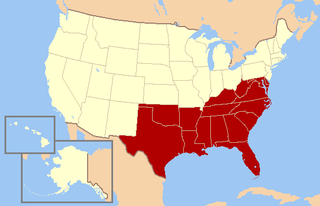
The Southern United States—commonly referred to as the American South, Dixie, or simply the South—is a region of the United States of America. The South does not exactly match the geographic south, but is predominantly located in the southeastern corner; Arizona and New Mexico, which are geographically in the southern part of the country, are rarely considered part of the Southern United States, while West Virginia, which separated from Virginia in 1863, commonly is. Some scholars have proposed definitions of the South that do not coincide neatly with state boundaries. While the states of Delaware and Maryland, as well as the District of Columbia permitted slavery prior to the start of the Civil War, they remained with the Union. Since then, they became more culturally, economically, and politically aligned with the industrial Northern states, and are often identified as part of the Mid-Atlantic and/or Northeast by many residents, businesses, public institutions, and private organizations. However, the United States Census Bureau puts them in the South.

South (Martian crater)
South Crater is an impact crater in the Mare Australe quadrangle of Mars, located at 77.1°S latitude and 338.0°W longitude. It is 107.1 km in diameter and was named after Sir James South, and the name was approved in 1973 by the International Astronomical Union (IAU) Working Group for Planetary System Nomenclature (WGPSN).
Very close to the crater there is what has been named "Swiss cheese" features. Swiss cheese features (SCFs) are pits so named because they look like the holes in Swiss cheese. They were first seen in 2000 using Mars Orbiter Camera imagery. They are usually a few hundred meters across and 8 metres deep, with a flat base and steep sides. They tend to have similar bean-like shapes with a cusp pointing towards the south pole. The angle of the sun probably contributes to their roundness. Near the Martian summer solstice, the sun can remain continuously just above the horizon; as a result the walls of a round depression will receive more intense sunlight, and sublimate much more rapidly than the floor. The walls sublimate and recede, while the floor remains the same. As the seasonal frost disappears, the pit walls appear to darken considerably relative to the surrounding terrain. The SCFs have been observed to grow in size, year by year, at an average rate of 1 to 3 meters, suggesting that they are formed in a thin layer (8m) of carbon dioxide ice lying on top of water ice.
South (disambiguation)
South is a cardinal direction.
South or The South may also refer to: