Please tell us which country and city you'd like to see the weather in.
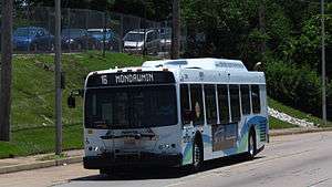
Route 16 (MTA Maryland)
Route 16 is a bus route operated by the Maryland Transit Administration in Baltimore. The line currently runs from the Mondawmin Metro Subway Station in Northwest Baltimore to Brooklyn Homes in South Baltimore through the communities of Rosemont (serving Coppin State College) and the corridors of Hilton Street, Caton Avenue, and Patapsco Avenue. During peak hours, selected trips operate via Violetville Industrial Park.
History
Route 16 was introduced in January 2001 when Route 22 was split. Service along its route started in 1971 as 22 EXTENDED.
Much of the current route of Route 16 historically was not served by a single transit route. Portions that were include North Avenue, which has been served by the no. 13 streetcar since 1890 and also the No. 31 streetcar, which later became the No. 19 streetcar (and is currently Bus Route 91); both these lines currently overlap. Bloomingdale Avenue and Poplar Grove Street were served by the Nos. 4 and 35 streetcars (currently Bus Route 15). Service on Fish House Road (where Patapsco Avenue is now located) between Annapolis Road and Brooklyn was provided by Short Line Routes.

Route-16 (video game)
Route-16 (ルート16, Rūto 16) is an arcade game released by Tehkan and Sun Electronics in 1981. The game was licensed to Centuri for distribution in the United States. It was also ported to the Emerson Arcadia 2001.
Plot
A racing game where the main character is the greed. Several cars battle each other on maze-like rooms trying to get the money bags and avoiding the dangers. In this game, everybody cares just about the money, showing that the money is the "route" of all evil.
Gameplay
The player controls a car which must explore a maze divided into sixteen rooms. He or she must get all the money bags while avoiding the opposite cars and trying not to run out of fuel. Every time the player goes out of a room, a map is shown, indicating the position of every car and all the money bags. There are also flags that can be driven over to invert the roles, so the player can crash the opposite cars and stop them for a few seconds, while getting bonus points.
Route-16 Turbo
Route-16 Turbo (ルート16ターボ, Rūto 16 Tābo) is an improved version of Route-16. It is also the Famicom port, which was developed and published on October 4, 1985 by Sunsoft only in Japan. This game features four swastikas in one of the rooms; in Japan this symbol does not carry the same negative connotations it has in the West.
List of MTA Maryland bus routes
The following is a list and description of the local, express and commuter bus routes of the Maryland Transit Administration, which serve Baltimore and the surrounding suburban areas.
Note: (Crosstown) = Bus service that is traveling across the city of Baltimore without going through the downtown area.
Local routes
Neighborhood Shuttle Bug routes
Shuttle and Circulator routes
School Supplementary routes
Local Express routes
INTRODUCING NEW NAMES FOR EXPRESS BUS LINES To better distinguish MTA’s Express Bus Lines from Local Routes MTA has converted all Express route numbers (X series) to 100 series numbers as of February 7th 2016. http://mta.maryland.gov/service-changes
Note:
QuickBus routes
Express routes
Intercounty Connector Bus routes
Commuter Bus routes
Former bus routes
References
External links

Delaware Route 16
Delaware Route 16 (DE 16) is an east-west state highway in Delaware, mainly across northern Sussex County, with a small portion near the Maryland border in extreme southwestern Kent County. It runs from Maryland Route 16 (MD 16) at the Maryland border in Hickman to the Delaware Bay at Broadkill Beach. The route runs through rural areas, passing through the towns of Greenwood, Ellendale, and Milton. DE 16 intersects U.S. Route 13 (US 13) and DE 36 in Greenwood, US 113 in Ellendale, DE 30 and DE 5 in the Milton area, and DE 1 between Milton and Broadkill Beach. West of DE 1, the route serves as part of a connection between the Baltimore-Washington Metropolitan Area and the Delaware Beaches. DE 16 was built as a state highway during the 1920s and 1930s. By 1936, the route was designated onto its current alignment.
Route description
DE 16 begins at the Maryland border in Hickman, Kent County, where the road continues west into that state as MD 16. From the state line, the route heads east on two-lane undivided Hickman Road, passing through a mix of farmland and woodland with some homes. The road crosses into Sussex County and turns to the southeast. DE 16 comes to an intersection with DE 36, at which point it turns east to form a concurrency with that route. The road enters Greenwood and becomes Market Street, passing several homes along with a few businesses. The highway crosses Norfolk Southern's Delmarva Secondary railroad line before it intersects US 13 on the eastern edge of Greenwood. Past this intersection, DE 16/DE 36 leaves Greenwood and becomes Beach Highway, crossing the Nanticoke River.

Maryland
Maryland ![]() i/ˈmɛrᵻlənd/ is a state located in the Mid-Atlantic region of the United States, bordering Virginia, West Virginia, and Washington, D.C. to its south and west; Pennsylvania to its north; and Delaware to its east. The state's largest city is Baltimore, and its capital is Annapolis. It has three occasionally used nicknames: the Old Line State, the Free State, and the Chesapeake Bay State.
i/ˈmɛrᵻlənd/ is a state located in the Mid-Atlantic region of the United States, bordering Virginia, West Virginia, and Washington, D.C. to its south and west; Pennsylvania to its north; and Delaware to its east. The state's largest city is Baltimore, and its capital is Annapolis. It has three occasionally used nicknames: the Old Line State, the Free State, and the Chesapeake Bay State.
One of the original Thirteen Colonies, Maryland is considered to be the birthplace of religious freedom in America, when it was formed in the early 17th century as an intended refuge for persecuted Catholics from England by George Calvert. George Calvert was the first Lord Baltimore and the first English proprietor of the then-Maryland colonial grant. Maryland was the seventh state to ratify the United States Constitution.
Maryland is one of the smallest states in terms of area, as well as one of the most densely populated states with nearly 6 million residents. With its close proximity to Washington, D.C., and a highly diversified economy spanning manufacturing, services, and biotechnology, Maryland has the highest median household income of any state.

Canal Parkway
Canal Parkway, which carries the unsigned Maryland Route 61 (MD 61) designation, is a state highway and automobile parkway in the U.S. state of Maryland. The road begins at the West Virginia state line at the Potomac River opposite Wiley Ford, where the highway continues south as West Virginia Route 28 (WV 28). The parkway runs 1.94 miles (3.12 km) north to MD 51 within the city of Cumberland. Canal Parkway provides a connection between downtown Cumberland and the South Cumberland neighborhood and with Greater Cumberland Regional Airport, which is located in Mineral County, West Virginia.
Canal Parkway was constructed as part of a broad group of projects to revitalize the Potomac River waterfront of Cumberland, centered on the historical Chesapeake and Ohio Canal (C&O Canal). The parkway was constructed both as a scenic highway and to improve access to South Cumberland and the airport, which were often cut off from the rest of Cumberland by flooding or traffic jams at the sole connecting point, a railroad underpass on Virginia Avenue. New bridges over the Potomac River and the C&O Canal were built in 1992 and 1997, while the portion of Canal Parkway from the canal crossing toward downtown Cumberland was constructed between 1999 and 2001.

Maryland Route 5
Maryland Route 5 (MD 5) is a 74.34-mile (119.64 km) long state highway that runs north–south in the U.S. state of Maryland. The highway runs from Point Lookout in St. Mary's County north to the Washington, D.C. border in Suitland, Prince George's County. MD 5 begins as the two-lane undivided Point Lookout Road which runs from Point Lookout, St. Mary's County, to an intersection with MD 235 in the northern part of the county. Point Lookout Road passes through rural areas as well as the county seat of Leonardtown. After the MD 235 intersection, the route becomes the four-lane divided Three Notch Road and continues into Charles County, where it becomes Leonardtown Road. Here, the route bypasses Hughesville and continues north toward the Waldorf area, which it bypasses to the east on Mattawoman Beantown Road. The route merges onto U.S. Route 301 (US 301, Crain Highway) and enters Prince George's County, splitting from US 301 at an interchange in Brandywine. From here, MD 5 continues north on Branch Avenue, running through suburban areas, before becoming a freeway as it passes Andrews Air Force Base and interchanges with Interstate 95 (I-95)/I-495 (Capital Beltway). Past the Capital Beltway, the route runs through suburban areas of Hillcrest Heights and Suitland before reaching the D.C. border, where Branch Avenue continues toward Pennsylvania Avenue.
Radio Stations - Maryland
SEARCH FOR RADIOS
Podcasts:
Maryland
ALBUMS
- Bedste danske julehits released: 1998
Maryland
ALBUMS
- Almond of Life released: 2004
- Rob & Jones Classic released: 2002
Maryland
ALBUMS
- Crossing and Blending released: 2006