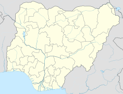
| Mopa-Muro | |
|---|---|
| — LGA — | |
|
|
|
| Coordinates: 8°05′50″N 5°53′45″E / 8.09722°N 5.89583°ECoordinates: 8°05′50″N 5°53′45″E / 8.09722°N 5.89583°E | |
| Country | |
| State | Kogi State |
| Area | |
| • Total | 901 km2 (348 sq mi) |
| Population (2006 census) | |
| • Total | 44,037 |
| Time zone | WAT (UTC+1) |
| 3-digit postal code prefix | 261 |
| ISO 3166 code | NG.KO.MM |
Mopa-Muro is a Local Government Area in Kogi State, Nigeria. Its headquarters are in the town of Mopa on the A123 highway.
It has an area of 901 km² and a population of 44,037 at the 2006 census.
The postal code of the area is 261.[1]
References [link]
- ^ "Post Offices- with map of LGA". NIPOST. https://www.nipost.gov.ng/PostCode.aspx. Retrieved 2009-10-20.
|
|||||||||||
| This Kogi State, Nigeria location article is a stub. You can help Wikipedia by expanding it. |
https://wn.com/Mopa-Muro
Podcasts:
-
by Bombay Bicycle Club
Maybe More
by: Bombay Bicycle ClubAnd he took whats left and he made for the door
oh so fast
oh so fast
while his act of theft put a smile on his face
but it wont last
it wont last no
will you decide to put this behind you
will you decide to put this behind you
will you decide to put this behind you
will you decide to put this behind you
and i gave my coat to the one i loved
we would walk
we would walk
but she changed the pace and she turned her face
she said its not us, were not old enough
will you decide to put this behind you
will you decide to put this behind you
will you decide to put this behind you
will you decide to put this behind you now
will you decide to put this behind you
will you decide to put this behind you
will you decide to put this behind you


