
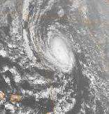
Hurricane Lili
Hurricane Lili was the second deadliest and second costliest hurricane of the 2002 Atlantic hurricane season, being surpassed by Hurricane Isidore, which affected the same areas around a week before Lili. Lili was the twelfth named storm, fourth hurricane, and second major hurricane of the 2002 Atlantic hurricane season. The storm developed from a tropical disturbance in the open Atlantic on September 21. It continued westward, affecting the Lesser Antilles as a tropical storm, then entered the Caribbean. As it moved west, the storm dissipated while being affected by wind shear south of Cuba, and regenerated when the vertical wind shear weakened. It turned to the northwest and strengthened up to category 2 strength on October 1. Lili made two landfalls in western Cuba later that day, and then entered the Gulf of Mexico. The hurricane rapidly strengthened on October 2, reaching Category 4 strength that afternoon. It weakened rapidly thereafter, and hit Louisiana as a Category 1 hurricane on October 3. It moved inland and dissipated on October 6.
Hurricane Lili (disambiguation)
The name Lili was used for four tropical cyclones in the Atlantic Ocean. Lili is not to be confused with Lily, which was used in the Pacific Ocean.
Hurricane Lili (1984)
Hurricane Lili was one of only five Atlantic tropical cyclones on record to reach hurricane status in the month of December. The final of thirteen tropical storms in the 1984 Atlantic hurricane season, Lili developed as a subtropical cyclone which originated from a frontal trough to the south of Bermuda on December 12. It tracked southeastward, then northward, slowly attaining tropical characteristics and becoming a hurricane on December 20. Lili turned to the south and southwest, briefly threatening the northern Caribbean islands before weakening and dissipating near the coast of the Dominican Republic. The storm produced light rainfall but no damage.
Meteorological history
In the second week of December, a frontal trough stalled south of Bermuda. An upper level disturbance moved over the area on December 9, and produced widespread convection along the frontal wave. The system moved to the northeast, and based on a developing circulation within the convection, the National Hurricane Center classified the system as a subtropical storm on December 12 while located 275 miles (440 km) northeast of Bermuda.