Hottentots Holland Mountains
The Hottentots Holland Mountains are part of the Cape Fold Belt in the Western Cape, South Africa. The mountain range forms a barrier between the Cape Town metropolitan area and the southern Overberg coast.
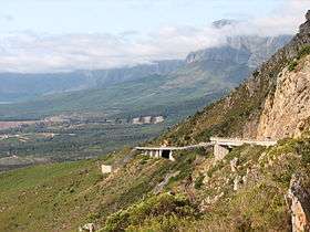
The range is primarily composed of Table Mountain Sandstone, and forms a large range between the Cape Town outlying suburbs of Somerset West and Gordon's Bay to the west, and the large Elgin valley to the east. Sir Lowry's Pass is the only crossing, in the form of the N2 motorway. The Steenbras Dam, one of Cape Town's main supply dams, is located in the southern section of the range. This is due to the abundant rainfall experienced in the uplands, located in the Elgin Valley around the town of Grabouw on the eastern slopes.
At the start of the Great Trek in 1835 when migrants decided to leave the Cape Town area, or Cape Colony as it was then known, the first mountain range they crossed was this range. Cuts and wheel markings from their ox wagons can still be seen in rock formations in the vicinity of Sir Lowry's Pass on this mountain range. This route still serves as the primary route out of the Cape Town area for travellers heading up the east coast of South Africa.
Podcasts:
Latest News for: hottentots-holland
Wildfires ravage 32 000 hectares of Western Cape land this fire season
Mail Guardian South Africa 25 Mar 2025- 1