Please tell us which country and city you'd like to see the weather in.
Hagley Park
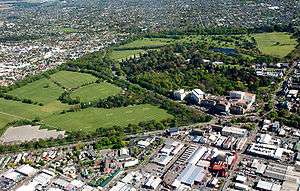
Hagley Park is the largest urban open space (164.637 hectares) in Christchurch, New Zealand, and was created in 1855 by the Provincial Government. According to the government's decree at that time, Hagley Park is "reserved forever as a public park, and shall be open for the recreation and enjoyment of the public." Hagley Park is characterised by its trees and broad open spaces. Hagley Park was named after Hagley Park, the country estate of Lord Lyttelton, who became chairman of the Canterbury Association in March 1850.
Location
The boundaries of the park, which is located in the central city of Christchurch, are defined by both the Avon River and the surrounding roadways. The longest road boundary is that along Deans Avenue on the western side adjacent to the suburb of Riccarton.
To the north and northeast, the natural path of the Avon River bounds the park. Moorhouse Avenue and Hagley Avenue form the south and south-eastern boundaries, respectively. Along the eastern boundary, the Park is defined by the two kilometre loop of the Avon River, which extends into the side of Hagley Park.
Hagley Park (disambiguation)
Hagley Park may refer to:
See also

Hagley
Coordinates: 52°26′N 2°07′W / 52.43°N 2.12°W
Hagley is a village and civil parish in Worcestershire, England. It is on the boundary of the West Midlands and Worcestershire counties between the Metropolitan Borough of Dudley and Kidderminster. The parish had a population of 4,283 in 2001, but the whole village had a population of perhaps 5,600, including the part in Clent parish. It is in Bromsgrove District.
Heritage
The parish of Hagley used to consist of Hagley, West Hagley and Blakedown. The main focus of the village was Hagley where Hagley Hall and the parish church of St John the Baptist (with its origins in Anglo-Saxon times) reside. In 1868 the Earl of Dudley defrayed one third of the cost of the tower and spire by George Edmund Street added to the church.
Lower Hagley started to expand with the arrival of the railway in 1852 and the building of a proper station and its iconic GWR footbridge (completed in 1884). The expansion of Lower Hagley (now known as West Hagley) initiated a shift in the focus of the village. This was recognised in 1906 with the building of a subsidiary parish church in Lower Hagley dedicated to St Saviour. and today West Hagley contains the shopping area and the schools. The precise dividing line between the two areas is undefined and is therefore debatable. Nevertheless, both settlements lie within the parish of Hagley.
Radio Stations - Hagley
Podcasts:
Latest News for: hagley park
Speed bumps or no speed bumps? Why not both? $500k for bizarre pedestrian crossing plan
NewstalkZB 02 Apr 2025'Kooky': Christchurch community boards react to proposed pedestrian crossing
NewstalkZB 01 Apr 2025Proposed pedestrian crossing 'bit of a joke' as different plans to be used for each side
RNZ 31 Mar 2025Planned Deans Ave pedestrian crossing 'a bit of a joke'
Otago Daily Times 31 Mar 2025- 1