Please tell us which country and city you'd like to see the weather in.
Eggersriet
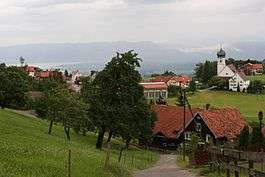
Eggersriet is a municipality in the Wahlkreis (constituency) of St. Gallen in the canton of St. Gallen in Switzerland.
History
Eggersriet is first mentioned in 1260 as Egglinsriet.
Geography
Eggersriet has an area, as of 2006, of 8.9 km2 (3.4 sq mi). Of this area, 56.9% is used for agricultural purposes, while 33.2% is forested. Of the rest of the land, 9.3% is settled (buildings or roads) and the remainder (0.6%) is non-productive (rivers or lakes).
The municipality was located in the Rorschach district, but since 2001 has been part of the St. Gallen Wahlkreis. It is located on the southern slope of the Rorschacherberg and along the Heiden-St. Gallen road. It consists of the village of Eggersriet and the hamlets of Dorf, Wisen and Egg in Eggersriet as well as Grub (SG).
Coat of arms
The blazon of the municipal coat of arms is Azure two Bulrushes proper issuant between three Mounts Vert.
Demographics
Eggersriet has a population (as of 31 December 2014) of 2,246.As of 2007, about 9.0% of the population was made up of foreign nationals. Of the foreign population, (as of 2000), 59 are from Germany, 6 are from Italy, 27 are from ex-Yugoslavia, 19 are from Austria, and 56 are from another country. Over the last 10 years the population has grown at a rate of 3.1%. Most of the population (as of 2000) speaks German (95.8%), with Albanian being second most common ( 0.7%) and French being third ( 0.6%). Of the Swiss national languages (as of 2000), 1,992 speak German, 13 people speak French, 9 people speak Italian, and 2 people speak Romansh.

St. Gallen
St. Gallen, or sometimes Sankt Gallen (![]() Sankt Gallen ; English: St Gall; French: Saint-Gall; Italian: San Gallo; Romansh: Son Gagl) is the capital of the canton of St. Gallen in Switzerland. It evolved from the hermitage of Saint Gall, founded in the 7th century. Today, it is a large urban agglomeration (with around 160,000 inhabitants) and represents the center of eastern Switzerland. The town mainly relies on the service sector for its economic base.
Sankt Gallen ; English: St Gall; French: Saint-Gall; Italian: San Gallo; Romansh: Son Gagl) is the capital of the canton of St. Gallen in Switzerland. It evolved from the hermitage of Saint Gall, founded in the 7th century. Today, it is a large urban agglomeration (with around 160,000 inhabitants) and represents the center of eastern Switzerland. The town mainly relies on the service sector for its economic base.
The main tourist attraction is the Abbey of Saint Gall, a UNESCO World Heritage Site. Its renowned library contains books which date back to the 9th century.
The official language of St. Gallen is (the Swiss variety of Standard) German, but the main spoken language is the local variant of the Alemannic Swiss German dialect.
The city has good transport links to the rest of the country and to neighbouring Germany and Austria. It also functions as the gate to the Appenzell Alps.
Geography
St. Gallen is situated in the northeastern part of Switzerland in a valley about 700 meters (2,300 ft) above sea level. It is one of the highest cities in Switzerland and it often receives a lot of snow in winter. The city is pleasantly situated between Lake Constance and the mountains of the Appenzell Alps (with the Säntis as the highest peak at 2,502 meters (8,209 ft)). It therefore offers excellent recreation areas nearby.

Canton of St. Gallen
The Canton of St. Gallen (German: Kanton ![]() St. Gallen , Swiss German: 'Sanggale') is a canton of Switzerland. St. Gallen is located in the north east of Switzerland. It covers an area of 2,026 km², and has a population (as of 31 December 2014) of 495,824.As of 2007, the population included 97,461 foreigners, or about 20.9% of the total population. The capital is St. Gallen. Spelling variations include: St. Gall, Saint Gall, Saint Gallen, Sankt Gallen, and Son Gagl.
St. Gallen , Swiss German: 'Sanggale') is a canton of Switzerland. St. Gallen is located in the north east of Switzerland. It covers an area of 2,026 km², and has a population (as of 31 December 2014) of 495,824.As of 2007, the population included 97,461 foreigners, or about 20.9% of the total population. The capital is St. Gallen. Spelling variations include: St. Gall, Saint Gall, Saint Gallen, Sankt Gallen, and Son Gagl.
History
The canton of St. Gallen is an artificial construct of various historical territories, defined by Napoleon Bonaparte in the Act of Mediation in 1803. About half of the canton's area corresponds to the acquisitions of the abbey of St. Gallen over centuries.
The city of St. Gallen became independent of the Abbey in 1405. At the same time, the Abbey lost control of the Appenzell. Conversely, the Toggenburg was acquired by the Abbey in 1468. Both the City and the Abbey were associates (Zugewandte Orte) of the Old Swiss Confederacy, but unlike Appenzell never joined as full members. The territories at Lake Zürich, Walensee and Rheintal remained independent until 1798. In the Helvetic Republic, the northern parts of the modern canton together with Appenzell became the Canton of Säntis, while its southern parts together with Glarus became the canton of Linth.
St. Gall (disambiguation)
St. Gall may refer to:
See also

Grub Street
Until the early 19th century, Grub Street was a street close to London's impoverished Moorfields district that ran from Fore Street east of St Giles-without-Cripplegate north to Chiswell Street. Famous for its concentration of impoverished 'hack writers', aspiring poets, and low-end publishers and booksellers, Grub Street existed on the margins of London's journalistic and literary scene. It was pierced along its length with narrow entrances to alleys and courts, many of which retained the names of early signboards. Its bohemian society was set amidst the impoverished neighbourhood's low-rent flophouses, brothels, and coffeehouses.
According to Samuel Johnson's Dictionary, the term was "originally the name of a street... much inhabited by writers of small histories, dictionaries, and temporary poems, whence any mean production is called grubstreet." Johnson himself had lived and worked on Grub Street early in his career. The contemporary image of Grub Street was popularised by Alexander Pope in his Dunciad.