Please tell us which country and city you'd like to see the weather in.
Fort Simpson
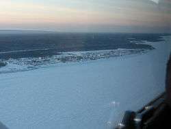
Fort Simpson (Slavey language: Liidli Kue "place where rivers come together") is a village, the only one in the entire territory, in the Dehcho Region of the Northwest Territories, Canada. The community is located on an island at the confluence of the Mackenzie and Liard Rivers. It is approximately 500 km (310 mi) west of Yellowknife. Both rivers were traditionally trade routes for the Hudson's Bay Company and the native Dene people of the area.
Fort Simpson is the regional centre of the Dehcho and is the gateway to the scenic South Nahanni River and the Nahanni National Park Reserve. Fort Simpson can be reached by air, water and road and has full secondary and elementary school service. The Mackenzie Highway was extended to Fort Simpson in 1970-71.
The central section of the community is on an island near the south bank of the Mackenzie River, but industrial areas and rural residential areas are located along the highway as far as the Fort Simpson Airport, just beyond which is the Liard River ferry crossing.
Fort Simpson (Columbia Department)
Fort Simpson was a fur trading post established in 1831 by the Hudson's Bay Company (HBC) near the mouth of the Nass River in present-day British Columbia, Canada. In 1834 it was moved to the Tsimpsean Peninsula, about halfway between the Nass River and the Skeena River, and was later referred to as Port Simpson or as the native name Lax Kw'alaams. The fort was part of the HBC's Columbia Department.
Economic Fur Trade
One of the primary reasons for the establishment of Fort Simpson, as well as Fort McLoughlin to the south, was to undermine the American dominance of the Maritime Fur Trade. By 1830 the higher prices paid for furs by American coastal traders had resulted in an indigenous fur trading system that diverted furs from the interior New Caledonia district of the HBC to the coast. Fort Simpson and Fort McLoughlin were built to intercept these furs before they could reach American traders, who had no permanent posts on the coast. The strategy was ultimately successful. By 1837 American competition was essentially over.
Radio Stations - Fort Simpson
SEARCH FOR RADIOS
Podcasts:
Latest News for: fort simpson
Texas AG investigating insurance company accused of spying on lawmakers, journalists, other Texans
Łı́ı́dlı̨ı̨ Kų́ę́ First Nation offers healing through on-the-land wellness camp
- 1