
In the United States, a farm-to-market road or ranch-to-market road (sometimes farm road or ranch road for short) is a state road or county road which traditionally served to connect rural or agricultural areas to market towns. These routes serve as a better quality road, usually a highway, which allows farmers and ranchers to transport their products to market towns and/or distribution centers.
Specifically, in the state of Texas, the terms Farm to Market Road and Ranch to Market Road indicate roadways that are part of the state's system of secondary and connecting routes, built and maintained by the Texas Department of Transportation (TxDOT). This system was established in 1949 as a project to provide access to rural areas. The system consists primarily of paved, two-lane roads. Generally, roads found west of US 281 (or Interstate 35 in some locations) are designated Ranch to Market Roads, while those located east of US 281 are designated Farm to Market Roads, though there are exceptions to this naming system, such as RM 2588 in Henderson County in East Texas.[1] Some segments are even expressways, including a segment of FM 1764 (the Emmett F. Lowry Expressway between Interstate 45 and Texas City, Texas).
Although these roads are signed with route markers that contain the words "FARM ROAD" or "RANCH ROAD", the proper name is "Farm to Market Road" and "Ranch to Market Road" (hence the abbreviation "F.M." and "R.M." on guide sign assemblies). The only road to explicitly use the nomenclature "Ranch Road" is Ranch Road 1, which runs near the former ranch home of former President Lyndon B. Johnson.[1]
As with other state-maintained highways in Texas, all Farm/Ranch to Market roads are paved. Speeds along Farm/Ranch to Market roads vary, but may be as high as 75 mph in rural areas, such as in Andrews and Pecos Counties (for example, along FM 1788, FM 1776, and FM 1053).
Contents |
History [link]

The first farm to market road in Texas was completed in January 1937, connecting Mount Enterprise and the former community of Shiloh in Rusk County. The route was 5.8 miles (9.3 km) long and was constructed at a cost of $48,015.12. This route is now part of Texas State Highway 315.[1] The first highway officially designated as FM 1 was authorized in 1941, connecting US 96 near Pineland to a sawmill belonging to the Temple Lumber Company.[2][3]
In 1945, the highway commission authorized a three-year pilot program for the construction of 7,205 miles (11,595 km) of farm-to-market roadway, with the cost to be shared equally by the state and federal governments.[4] As the program grew, efforts were made by legislators from rural areas, including State Senator Grady Hazlewood of Amarillo, to expand the farm-to-market road network in the late 1940s.[5] The funding was to have come from an increase in the gasoline tax, as proposed by State Senator Grover Morris in 1947; however, this measure was stymied by lobbyists, who indicated that such funding should go to arterial routes.[6] Nonetheless, the popularity of the program and the perceived need to connect the vast, isolated central and western areas of the state prompted the passing of the Colson-Briscoe Act in 1949, sponsored by State Senator E. Neveille Colson and State Representative Dolph Briscoe.[7] This legislation appropriated funding for the creation of an extensive system of secondary roads to provide access to the rural areas of the state and to allow farmers and ranchers to bring their goods to market, reserving a flat $15 million per year plus 1 cent per gallon of gasoline sold in the state for local highway construction.[3] In 1962, the Texas legislature increased this amount to no less than $23 million annually, through federal fund matching, and expanded the farm-to-market system from 35,000 to 50,000 miles (56,000 to 80,000 km).[8][9] The system now accounts for over half of the mileage in the Texas Department of Transportation system.
Identification [link]
Signs designating a Farm to Market or Ranch to Market road are a black square background containing a white shape of the state of Texas, with the words "FARM ROAD" or "RANCH ROAD" appearing in white text on the background and the route number in black text within the shape of Texas. Guide signs (the large green signs usually found along highways) designating these roads use a simple white rectangle with the abbreviation "F.M." or "R.M." and the route number appearing below the abbreviation in black text.[10]
As a result of population growth and the expansion of urban areas, many Farm to Market and Ranch to Market roads that originally served rural areas now serve urban areas, sometimes exclusively. An effort was made to rename such roads "urban roads" in 1995, but residents opposed the effort, arguing that removing the "Farm" and "Ranch" from the designations was "un-Texan," and that the cost of changing signage was not justified. Other than a few route markers, such as on FM 1315 near Victoria, most signs were not changed, and TxDOT abandoned the idea to do so.[11] However, though the Farm to Market and Ranch to Market designations remain in place on route signage, the state does continue to track these Urban Roads separately in its highway designation files. For example, the mileage of FM 544 in the Plano area was transferred from FM 544 to UR 544 in 1995.[12][13] As part of the state highway system, Urban Roads are eligible for state maintenance; however, unlike rural Farm to Market and Ranch to Market roads, they do not receive state funding for expansion.[14]
Farm to Market and Ranch to Market roads are numbered as a single set of roads; that is, there should not be an FM and an RM with the same route number, unless it crosses US 281. Urban Roads are designated with the same route number as the FM or RM from which the mileage was transferred.[15]
-
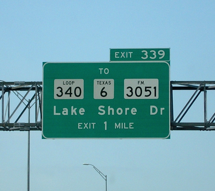
Guide sign: destination sign along Interstate 35 showing typical signage for a Farm to Market Road (right), along with signage for a State Highway Loop (left) and a State Highway (center) for comparison.


Business routes [link]

Texas currently has three signed business routes of Farm to Market Roads: Business FM 1187 in Tarrant County, Business RM 1431 in Burnet County, and Business FM 1960 in Harris County.[16][17][18] These routes are former alignments that have been bypassed by newer routings.
Other states [link]
Missouri has a similar state-operated system of farm-to-market roads, called Missouri supplemental routes. Missouri uses single (e.g., "A", "B", etc.) and double letters (e.g., "AA", "BB", etc.).
Iowa also has a farm-to-market road system. Those roads are under county jurisdiction,[19] but are eligible for state aid from a dedicated fund.[20]
See also [link]
References [link]
- ^ a b c Staff. "Farm/Ranch to Market Facts". Texas Department of Transportation. https://www.dot.state.tx.us/tpp/hwy/fmfacts.htm. Retrieved February 26, 2008.
- ^ Transportation Planning and Programming Division. "Highway Designation File – Farm to Market Road No. 1". Texas Department of Transportation. https://www.dot.state.tx.us/tpp/hwy/FM/FM0001.htm. Retrieved April 8, 2011.
- ^ a b Burka, Paul (April 1983). "Texas Primer: The Farm-to-Market Road". Texas Monthly 11 (4): 134. https://books.google.com/books?id=8SwEAAAAMBAJ&lpg=PA122&pg=PA134#v=onepage&q&f=false.
- ^ "Texas to improve farm to market roads". Harper Herald: p. 3. June 15, 1945. https://news.google.com/newspapers?id=RX1LAAAAIBAJ&sjid=JSQNAAAAIBAJ&pg=4709,493868. Retrieved April 8, 2011.
- ^ Followwill-Line, Robyn (May 19, 2000). "Grady Hazlewood". Amarillo Globe-News. https://amarillo.com/stories/051900/his_hazlewood.html. Retrieved April 8, 2011.
- ^ Smith, Griffin Jr. (April 1974). "The Highway Establishment and How It Grew". Texas Monthly 2 (4): 86.
- ^ Texas Transportation Institute. "Texas Transportation Hall of Honor: Inductees: 2005". Texas A&M University System. https://tti.tamu.edu/hall_of_honor/inductees/2005.htm. Retrieved April 8, 2011.
- ^ Kite, Kirk. "Highway Development". Handbook of Texas Online. Texas State Historical Association. https://www.tshaonline.org/handbook/online/articles/erh02. Retrieved April 7, 2011.
- ^ Texas Department of Transportation. "TxDOT History: 1970 to 1951". https://www.txdot.gov/about_us/1970_1951.htm. Retrieved April 8, 2011.
- ^ Texas Department of Transportation (October 2008). Freeway Signing Handbook. pp. 4-9–4-10. https://onlinemanuals.txdot.gov/txdotmanuals/fsh/index.htm. Retrieved April 8, 2011.
- ^ Hughes, Sharon (July 16, 1995). "Highway officials nix urban road designation". Victoria Advocate. Associated Press. https://news.google.com/newspapers?id=pSVSAAAAIBAJ&sjid=DjYNAAAAIBAJ&pg=1946,2751619. Retrieved April 7, 2011.
- ^ Transportation Planning and Programming Division. "Highway Designation File – Farm to Market Road No. 544". Texas Department of Transportation. https://www.dot.state.tx.us/tpp/hwy/FM0500/FM0544.htm. Retrieved April 7, 2011.
- ^ a b Transportation Planning and Programming Division. "Highway Designation File – Urban Road No. 544". Texas Department of Transportation. https://www.dot.state.tx.us/tpp/hwy/UR/UR0544.htm. Retrieved April 7, 2011.
- ^ Babineck, Mark (August 18, 2007). "Tex-Arcana: What's a farm-to-market road?". Houston Chronicle. https://www.chron.com/disp/story.mpl/metropolitan/5065822.html. Retrieved April 8, 2011.
- ^ Texas Department of Transportation. "Highway Designations Glossary". https://www.dot.state.tx.us/business/governments/glossary.htm. Retrieved April 8, 2011.
- ^ Transportation Planning and Programming Division. "Highway Designation File – Business Farm to Market Road No. 1187-C". Texas Department of Transportation. https://www.dot.state.tx.us/tpp/hwy/BF/BF1187C.htm. Retrieved April 7, 2011.
- ^ Transportation Planning and Programming Division. "Highway Designation File – Business Farm to Market Road No. 1431-J". Texas Department of Transportation. https://www.dot.state.tx.us/tpp/hwy/BF/BF1431J.htm. Retrieved April 7, 2011.
- ^ Transportation Planning and Programming Division. "Highway Designation File – Business Farm to Market Road No. 1960-A". Texas Department of Transportation. https://www.dot.state.tx.us/tpp/hwy/BF/BF1960A.htm. Retrieved April 7, 2011.
- ^ Iowa Code 2003: Section 306.3. Retrieved March 28, 2006
- ^ Iowa Code 2001: Section 312.5. Retrieved March 28, 2006.
External links [link]
| Wikimedia Commons has media related to: Texas Farm Road |
|
|||||||||||||||||||||||||||||||||
|
||||||||||||||||||||
https://wn.com/Farm-to-market_road

Farm to Market Road 3005
Farm to Market Road 3005 is a farm to market road in Galveston County, Texas.
Route description
FM 3005 has a western terminus at the approach to the toll bridge over San Luis Pass; the bridge connects to the Bluewater Highway (County Road 257) on the Brazoria County side. It travels to the northeast along Termini–San Luis Pass Road, through Galveston (and briefly Jamaica Beach), crossing Galveston Island State Park and passing Scholes International Airport before entering the Galveston central business district. Beginning near Cove View Boulevard, the route is signed as Seawall Boulevard, as it runs alongside the Galveston Seawall. The FM 3005 designation ends at Spur 342 (61st Street), which provides access to Interstate 45. Seawall Boulevard continues under county maintenance to SH 87 on the eastern side of the island.
History
FM 3005 was first designated in Galveston County in 1966; its western terminus was at 13 Mile Road. The route was lengthened to the boundary of Galveston Island State Park in 1972, and through the park and to the San Luis Pass Toll Bridge in 1988. The designation was officially changed to Urban Road 3005 (UR 3005) in 1995; as is the case with other urban roads, TxDOT continues to sign the route using the "Farm Road" shield.

Farm to Market Road 2255
Farm to Market Road 2255 (FM 2255) is a farm to market road located in Lubbock, Texas. The entire highway is internally designated as Urban Road 2255 (UR 2255) by TxDOT.
Route description
FM 2255 begins at an intersection with Spur 309 in Lubbock near Reese Center. The highway runs east, meeting FM 179 (Inler Avenue) at a stop sign-controlled intersection. Between Inler Avenue and Milwaukee Avenue, FM 2255 runs in a rural area of northern Lubbock. East of Milwaukee Avenue, the highway sees much more development along its route, including commercial developments and numerous subdivisions. From Quaker Avenue to US 82 (Marsha Sharp Freeway), FM 2255 runs through the northern half of Texas Tech University and passes by University Medical Center. The highway ends at an interchange with the Marsha Sharp Freeway.
The entire highway is known locally in Lubbock as 4th Street.
Junction list
The entire route is in Lubbock, Lubbock County.
References

Farm to Market Road 1472
Farm to Market Road 1472 (FM 1472) is a farm-to-market road that connects the Laredo, Texas Industrial Area to the Colombia – Solidarity International Bridge, then running roughly parallel to the Rio Grande into rural Webb County. In the urban sections of Laredo, it is a six-lane route known locally as Mines Road.
Route description
The southern terminus of FM 1472 is in Laredo, at IH 35 Exit #4. The route travels to the north and crosses I-69W/US 59/Loop 20. It then takes more of a northwesterly direction, paralleling the Rio Grande. It has a junction with SH 255, the Camino Colombia Toll Road, near the Laredo city limits. The route continues through unincorporated Webb County before reaching the end of its designation north of Carricitos Creek. The unimproved roadway continues as Eagle Pass Road, which becomes the paved FM 1021 after crossing into Maverick County.
History
FM 1472 was originally designated in 1948 on a route from US 82 in Crosbyton to Wake School in Crosby County; this route was cancelled and combined with FM 28 in 1954. The current FM 1472 was designated in 1955, from the junction of what was then US 81 to the community of Dolores. The designation was extended four times: by approximately six miles in 1962, by four miles in 1969, by another four miles in 1971, and by another two miles in 1981 to its current length. The portion of the route between Interstate 35 and SH 255 was officially redesignated as Urban Road 1472 in 1995 due to the growth of the Laredo urban area and the construction of the Columbia-Solidarity International Bridge northwest of the city. As with other urban roads, the signage retains its Farm Road shields.