Please tell us which country and city you'd like to see the weather in.

Dunstable Downs
Dunstable Downs are part of the Chiltern Hills, in southern Bedfordshire in England. They are a chalk escarpment forming the north-eastern reaches of the Chilterns. At 797 ft (243 m), Dunstable Downs are the highest point of the county of Bedfordshire.
Because of its elevation, Dunstable Downs hosted a station in the shutter telegraph chain which connected the Admiralty in London to its naval ships in the port of Great Yarmouth during the years 1808 to 1814.
Whipsnade Zoo has cut an enormous lion shape into the chalk into the side of one of the hills. The lion can be seen from the B489 (Aylesbury to Dunstable road).
The downs are used by gliders, kite fliers, hang gliders and paragliders in the area because of their height. The London Gliding Club is based at the foot of the downs.
Much of the downs are managed by the National Trust as part of the Dunstable Downs, Countryside Centre & Whipsnade Estate property.
Ascents
Central Bedfordshire Council and the National Trust commissioned Architype architects to build a visitor centre known as the Chilterns Gateway Centre, on the very top of Dunstable Downs. The summit is right next to the B4541 road that crosses the hill, and so an ascent of the hill requires nothing more than getting out of a car at the highest point and walking across to the trig point.
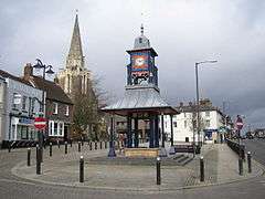
Dunstable
Coordinates: 51°53′10″N 0°31′16″W / 51.88603°N 0.52102°W / 51.88603; -0.52102
Dunstable /ˈdʌnstəbəl/ is a market town and civil parish located in Bedfordshire, England. It lies on the eastward tail spurs of the Chiltern Hills, 30 miles (50 kilometres) north of London. These geographical features form several steep chalk escarpments most noticeable when approaching Dunstable from the north.
Etymology
In Roman times its name was Durocobrivis. There was a general assumption that the nominative form of the name had been Durocobrivae, so that is what appears on the map of 1944 illustrated below. But current thinking is that the form Durocobrivis, which occurs in the Antonine Itinerary, is a fossilised locative that was used all the time and Ordnance Survey now uses this form.
There are several theories concerning its modern name:

Dunstable, Massachusetts
Dunstable (/ˈdʌnstəbəl/ DUN-stə-bəl) is a town in Middlesex County, Massachusetts, United States. The population was 3,179 at the 2010 census.
Etymology
Dunstable was named after its sister town Dunstable, England. There are several theories concerning its modern name. In one version, legend tells that the lawlessness of the time was personified in a thief called Dun. Wishing to capture Dun, the King stapled his ring to a post daring the robber to steal it. It was, and was subsequently traced to the house of the widow Dun. Her son, the robber, was taken and hanged to the final satisfaction that the new community bore his name. Another theory is that it comes from the Anglo-Saxon for "the boundary post of Duna". A third version is that the name is derived from Dunum, or Dun, a hill, and Staple, a marketplace.
History
Dunstable was first settled in 1656 and was officially incorporated in 1673. It is likely named after the town of Dunstable in Bedfordshire, England, home of Edward Tyng, the town's first settler. The original township of Dunstable, granted in 1661, consisted of two hundred square miles, including the Massachusetts towns of Dunstable, Pepperell, Townsend and Tyngsborough, the New Hampshire towns of Hudson, Nashua and Hollis, and parts of other towns as well. Increases in population leading to subsections becoming independent towns and the solidification of the northern boundary of Massachusetts in 1740 placed the northern part of Dunstable (present day Nashua) in New Hampshire, so the southern part remains the Dunstable of today.