Bay of Campeche
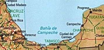
The Bay of Campeche (Spanish: Bahia de Campeche) is the southern bight of the bodies of water of the Gulf of Mexico. It is surrounded on three sides by the Mexican states of Campeche, Tabasco and Veracruz. The area of the bay is 6,000 square miles (16,000 km2) and maximum depth of the bay is approximately 180 feet (55 m). It was named by Francisco Hernández de Córdoba and Antón de Alaminos during their expedition in 1517.
Oil resource
The Cantarell Complex of five oil fields lies beneath the Bay of Campeche. In 2003 it was the second most productive oil field in the world, then supplying about two thirds of Mexico's crude oil output, but it went into a steep decline soon thereafter.
On June 3, 1979, Ixtoc I, an exploratory oil well located in the bay, suffered a blowout that caused a catastrophic explosion, resulting in what has been ranked as the third largest unintentional oil spill in history.
Climate
During the months of June and July, the Bay of Campeche is considered one of the "hot" breeding spots for Atlantic hurricanes. The bay is also considered the eastern border on the main migration routes for birds in the Americas.

Campeche
Campeche (![]() kamˈpetʃe ), officially Free and Sovereign State of Campeche (Spanish: Estado Libre y Soberano de Campeche), is one of the 31 states which, with the Federal District, comprise the 32 Federal Entities of Mexico. Located in Southeast Mexico, it is bordered by the states of Tabasco to the south west, Yucatán to the north east, and Quintana Roo to the east, and to the southeast by the Orange Walk district of Belize, and the Petén department of Guatemala to the south. It has a coastline to the west with the Gulf of Mexico. The state capital, also called Campeche, was declared a World Heritage Site in 1997. The formation of the state began with the city, which was founded in 1540 as the Spanish began the conquest of the Yucatán Peninsula. During the colonial period, the city was a rich and important port, but declined after Mexico’s Independence. Campeche was part of the province of Yucatán but split off in the mid-19th century, mostly due to political friction with city of Mérida. Today, much of the state’s economic comeback is due to the finding of petroleum offshore in the 1970s, which has made the coastal cities of Campeche and Ciudad del Carmen important economic centers. The state has important Mayan and colonial sites but they are not as well known or visited as others in the Yucatán.
kamˈpetʃe ), officially Free and Sovereign State of Campeche (Spanish: Estado Libre y Soberano de Campeche), is one of the 31 states which, with the Federal District, comprise the 32 Federal Entities of Mexico. Located in Southeast Mexico, it is bordered by the states of Tabasco to the south west, Yucatán to the north east, and Quintana Roo to the east, and to the southeast by the Orange Walk district of Belize, and the Petén department of Guatemala to the south. It has a coastline to the west with the Gulf of Mexico. The state capital, also called Campeche, was declared a World Heritage Site in 1997. The formation of the state began with the city, which was founded in 1540 as the Spanish began the conquest of the Yucatán Peninsula. During the colonial period, the city was a rich and important port, but declined after Mexico’s Independence. Campeche was part of the province of Yucatán but split off in the mid-19th century, mostly due to political friction with city of Mérida. Today, much of the state’s economic comeback is due to the finding of petroleum offshore in the 1970s, which has made the coastal cities of Campeche and Ciudad del Carmen important economic centers. The state has important Mayan and colonial sites but they are not as well known or visited as others in the Yucatán.

Campeche City
San Francisco de Campeche (pronounced: [san fɾanˈsisko de kamˈpetʃe]) (Ahk'ìin Pech - /aχkʼiːn˥˧ pʰetʃ/ in Yucatec Maya) is a city in Campeche Municipality in the state of Campeche —located at 19°51′N 90°32′W / 19.85°N 90.53°W / 19.85; -90.53, on the shore of the Bay of Campeche of the Gulf of Mexico— and its municipal seat also serves as the state's capital city. The city's population at the 2010 census was 220,389, and the municipality for which it serves as municipal seat had a population of 259,005.
The city was founded in 1540 by Spanish conquistadores as San Francisco de Campeche atop the pre-existing Maya city of Can Pech. The Pre-Columbian city was described as having 3,000 houses and various monuments, of which little trace remains.
The city retains many of the old colonial Spanish city walls and fortifications which protected the city (not always successfully) from pirates and buccaneers. The state of preservation and quality of its architecture earned it the status of a UNESCO World Heritage Site in 1999. Originally, the Spaniards lived inside the walled city, while the natives lived in the surrounding barrios of San Francisco, Guadalupe and San Román. These barrios still retain their original churches; the one in Guadalupe is almost 500 years old.
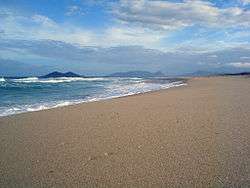
Campeche, Florianópolis
Campeche is a beach located on the south of the city of Florianópolis, on the south of Brazil.
There used to be a proper airport which was inaugurated in 1927 by the French Compagnie générale aéropostale. Aéropostale's planes used to land on it. It is plausible that the famous French pilot and writer Antoine de Saint-Exupéry, author of the classic The Little Prince, would have made a few landings on the area after the death of the pilot Élysée Négrin in 1930, while he was in charge of controlling the flights of Aeroposta Argentina.
There are many houses to rent as well as pousadas (hostels), bars and simple restaurants. From any point along its 11.5 kilometres (7.1 mi) length, the island of Campeche can be seen.
References
Coordinates: 27°40′59″S 48°29′30″W / 27.68306°S 48.49167°W / -27.68306; -48.49167