Please tell us which country and city you'd like to see the weather in.

All Hallows Lombard Street
Coordinates: 51°30′44″N 0°05′08″W / 51.5122°N 0.0855°W / 51.5122; -0.0855
All Hallows Lombard Street was a parish church in the City of London. It stood in Lombard Street near the corner with Gracechurch Street, in Langbourn Ward, The west end faced into Ball Alley. Of medieval origin, it was rebuilt following the Great Fire of London. It was demolished in 1937; its tower was reconstructed at Twickenham as part of the new church of All Hallows, which also received its bells and complete interior fittings.
Medieval church
All Hallows is first recorded in 1054, when a citizen of London called Brihtmerus gave its patronage to the prior and chapter of Canterbury Cathedral.John Stow calls it "All Hallows Grasse Church" because "the grass market went down that way, when that street was far broader than now it is".
The church was rebuilt around the beginning of the 16th century. The south aisle is recorded as having been completed in 1516. The north aisle and other works were paid for by the Pewterer's Company. The bell tower was completed in 1544 and the stone porch from the dissolved monastery of St John of Jerusalem, near Smithfield was reconstructed at All Hallows. The monastery's bells also were purchased, but, due to the death of a benefactor, never installed, leaving the tower with only one bell.
All Hallows
All Hallows may refer to:
Churches
England
Other places
Education
Other uses
See also
Lombard Street
Lombard Street may refer to:

Lombard Street, London
Lombard Street is a street in the City of London, notable for its connections with the City's merchant, banking and insurance industries, stretching back to medieval times.
From the junction at Bank, where nine streets converge by the Bank of England, Lombard Street runs southeast for a short distance, before bearing left into a more easterly direction, and terminates at a junction with Gracechurch Street and Fenchurch Street. Its overall length is 1⁄4 km (1⁄6 mi).
It has often been compared with Wall Street in New York City.
Description
Lombard Street, since the construction of King William Street, has two distinctive sections. The short section between Bank and the church of St Mary Woolnoth is spacious and has two-way traffic (including several bus routes) which continues along King William Street. The street then bears to the east and the remainder is much narrower (retaining its medieval character) and is one-way, with vehicular traffic directed east to west.
At the eastern end of the street, a number of modern buildings exist on both sides of the street, in contrast to the older buildings and architectural styles along much of it length. Built 1990–92, the former headquarters building of Barclays covers a large plot on the north corner of Lombard and Gracechurch Streets, and is the largest and tallest building in the vicinity of Lombard Street at 87 metres (285 ft) high.

Lombard Street (San Francisco)
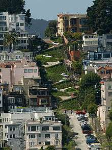
Lombard Street is an east–west street in San Francisco, California that is famous for a steep, one-block section with eight hairpin turns. The street was named after Lombard Street in Philadelphia by San Francisco surveyor Jasper O'Farrell.
Route description
Lombard Street's west end is at Presidio Boulevard inside The Presidio; it then heads east through the Cow Hollow neighborhood. For twelve blocks, between Broderick Street and Van Ness Avenue, it is an arterial road that is co-signed as U.S. Route 101. Lombard Street continues through the Russian Hill neighborhood and to the Telegraph Hill neighborhood. At Telegraph Hill it turns south, becoming Telegraph Hill Boulevard to Pioneer Park and Coit Tower. Lombard Street starts again at Winthrop Street and ends at The Embarcadero as a collector road.
Lombard Street is known for the one-way block on Russian Hill between Hyde and Leavenworth Streets, where eight sharp turns are said to make it the most crooked street in the world. The design, first suggested by property owner Carl Henry and built in 1922, was intended to reduce the hill's natural 27% grade, which was too steep for most vehicles. It is also a hazard to pedestrians, who are accustomed to shallow inclines, up to 4.86° because of wheel chair navigability concerns. The crooked block is perhaps 600 feet (180 m) long (412.5 feet (125.7 m) straightline), is one-way (downhill) and is paved with red bricks. The sign at the top recommends 5 mph (8 km/h).
Radio Stations - All_Hallows_Lombard_Street
SEARCH FOR RADIOS
Podcasts:

