Draft:Sediments

Sediment is particulate matter that is deposited on the surface of land.
The land can be exposed to outer space, an atmosphere, or under a liquid object.
For the projection above: "Sediment thickness values represent an average over each 5-minute grid cell and are located at the center of each cell."[1]
Lithification
[edit | edit source]
Def. the "compaction and cementation of sediment into rock"[2] is called lithification.
Def. a "subdivision of any stratigraphic unit that has characteristic lithologic features"[3] is called a lithofacies.
Def. the "formation of sedimentary rock"[4] is called lithogenesis.
Def. "an element that forms silicates or oxides and is concentrated in the minerals of the Earth's crust"[5] is called a lithophile.
"The rocks are quartzose sandstones that were deposited on the eastern shore of ancient Lake Uinta, which existed during the Eocene. Some wisps and ribbons of dark-colored, magnetite-rich sand are present in the sandstone. The variety of chaotic rockforms at Fantasy Canyon are quite diverse - these cannot be explained by ordinary weathering and erosion. Close examination shows that erosion has acted upon differentially cemented sandstone. The sandstone has not undergone complete lithification and diagenesis - groundwater lobes have preferentially cemented portions of the sandstone, especially immediately adjacent to joint planes. The poorly-cemented sandstone was easily eroded & the better-cemented sandstone remains."[6]
"Fantasy Canyon [is located] between Red Wash & Coyote Wash, Chapita Wells Gas Field, west-northwest of the town of Bonanza & south-southeast of the town of Vernal & east of the town of Ouray, northeastern Utah, USA."[6]
Theoretical sediments
[edit | edit source]Def. a "collection of small particles, particularly dirt, that precipitates from a river or other body of water"[7] is called a sediment.
Sedimentology
[edit | edit source]
Sedimentology is the science and study of sediments.
With appropriate conditions, sediment is transformed into rock. These are the sedimentary rocks.
Def. a "study of natural sediments and of the processes by which they are formed"[8] is called sedimentology.
Erratics
[edit | edit source]

Def. a "rock moved from one location to another"[9] is called an erratic.
Regoliths
[edit | edit source]
Def. a "layer of loose rock, dust, sand, and soil, resting on the bedrock, that constitutes the surface layer"[10] is called a regolith.
Turbidites
[edit | edit source]

Def. "sea-bottom deposits formed by massive slope failures where rivers have deposited large deltas"[11] are called turbidites.
"Turbidites [shown in the image on the right] are sea-bottom deposits formed by massive slope failures where rivers have deposited large deltas. These slopes fail in response to earthquake shaking or excessive sedimentation load. The temporal correlation of turbidite occurrence for some deltas of the Pacific Northwest suggests that these deposits have been formed by earthquakes."[11]
"Turbidites (interbedded with mudstones/siltstones) from the Ross Sandstone Formation Turbidite system of Namurian age in County Clare, Western Ireland. The sandstone beds were formed in a deep basin by turbidites coming from a delta area."[11]
Diamictons
[edit | edit source]
Def. "nonsorted, noncalcareous terrigenous deposits composed of sand and/or larger particles dispersed through a muddy matrix"[12] are called diamictons.
"The bluffs [in the image on the right] near the confluence of the Gakona and Copper Rivers expose nearly 300 ft of the Quaternary lacustrine, alluvial, and glacial deposits that fill the Copper River Basin. Most of the section seen in this view consists of finely laminated to indistinctly bedded sand, silt, and clay, with or without coarser material, that was deposited in glacial Lake Atna. A few beds contain organic material that has been dated by radiocarbon-age techniques. Outcrops in the lower left foreground (glove for scale) consist of alternating thin beds of coarser and fi ner grained material. The fractured, lighter colored beds above them are varved silt and clay. Beyond the scattered trees, the middle part of the section includes interbedded diamicton, silt, and sand. Some of the poorly sorted diamicton beds were probably deposited by slumping of deposits on the bottom of the lake, but other diamicton beds could represent the advance of glaciers into the lake. The upper 30 ft of the bluff consists of windblown sand and silt, some of which still is accumulating today. The entire section below the windblown material was deposited during the last major glaciation in Alaska between about 58,000 and 9,400 years ago, as dated here, and indicates rapid erosion of the mountains that surround the Copper River Basin."[13]
Drifts
[edit | edit source]
Def. a "mass of matter which has been driven or forced onward together in a body, or thrown together in a heap"[14] is called drift.
The image on the right shows morainic drift on the surface north of the surge glacier Brúarjökull in Iceland.
Tills
[edit | edit source]
Def. "glacial drift consisting of a mixture of clay, sand, pebbles and boulders"[15] is called till, or glacial till.
The image on the right shows glacial till exposed in a road cut with some plants growing on top.
Alluviums
[edit | edit source]
Def. "soil, clay, silt or gravel deposited by flowing water, as it slows, in a river bed, delta, estuary or flood plain"[16] is called alluvium.
Outwashes
[edit | edit source].JPG)
Def. a "sediment (mostly sand and gravel) deposited by water flowing from a melting glacier"[17] is called an outwash.
Lahars
[edit | edit source]
Def. a volcanic mudflow is called a lahar.
Part of the Mount St. Helens lahar entered Spirit Lake (lower left corner of the image on the right) but most of the flow went west down the Toutle River, eventually reaching the Cowlitz River, 50 miles (80 kilometers) downstream.
Layered sediments
[edit | edit source]
Def. "a pair of sedimentary layers, a couplet, that form in an annual cycle as the result of seasonal weather changes"[18] is called a varve.
"Typically formed in glacial lakes a varve couplet consists of a coarser grained summer layer formed during open-water conditions, and a finer grained winter layer formed from deposition from suspension during a period of winter ice cover. Many varve deposits contain hundreds of couplets."[18]
"The ruin marble structure of the Cretaceous/Paleogene fine-grained marly limestone from the Outer Flysch Belt of the Western Carpathians has a non-tectonic origin, according to structural and sedimentological evidence. Distinctive offsets of coloured red-brownish ferric oxyhydroxide bands are not due to displacements along rock-cutting fractures, as they superficially appear to be. Evidences for shear movement along these pseudo-faults were not observed. Band offsets result from different velocities of pervasively diffusing fluids, precipitating ferric oxyhydroxides in corridors bounded by sets of mineralised systematic joints. During rock weathering, calcite-filled joints operated as barriers for lateral fluid diffusion, but enabled longitudinal diffusion along healed joints."[19]
Liesegang rings
[edit | edit source]
Def. secondary "rings or bands resulting from rhythmic precipitation in a gel, or within a fluid-saturated rock"[20] are called Liesegang rings.
Loesses
[edit | edit source]
Def. any "sediment, dominated by silt"[21] is called loess.
Def. fine-grained, "silt-size sediment formed by the mechanical erosion of bedrock at the base and sides of a glacier by moving ice"[18] is called rock flour.
"When [rock flour] enters a stream, it turns the stream's color brown, gray, iridescent blue-green, or milky white. [It is also] called Glacier Flour or Glacier Milk."[18]
Soils
[edit | edit source]
Def.
- a "mixture of sand and organic material, used to support plant growth",[22]
- an "unconsolidated mineral or organic material on the immediate surface of the earth that serves as a natural medium for the growth of land plants",[22] and
- an "unconsolidated mineral or organic matter on the surface of the earth that has been subjected to and shows effects of genetic and environmental factors of: climate (including water and temperature effects), and macro- and microorganisms, conditioned by relief, acting on parent material over a period of time"[22]
is called a soil.
"The Port series [shown in the profile on the right] consists of very deep, well-drained, moderately permeable, nearly level and very gently sloping soils on flood plains that are subject to frequent, occasional, or rare flooding. These soils are in western and central Oklahoma. They are in 33 of the 77 counties and make up about 1 million acres."[23]
"These soils formed in calcareous, loamy alluvium and under native grasses. A high volume of organic matter recycled in a grass ecosystem has resulted in good soil structure and tilth. Most areas of the soils are used as cropland. The main cultivated crops are alfalfa, wheat, grain sorghum, and cotton. Some areas are used as pasture or rangeland."[23]
The pedosphere interfaces with the lithosphere, the hydrosphere, the atmosphere, and the biosphere.[24]
Soil consists of a solid phase of minerals and organic matter (the soil matrix), as well as a porous phase that holds gases (the soil atmosphere) and water (the soil solution).[25][26][27] Accordingly, soil scientists can envisage soils as a three-state system of solids, liquids, and gases.[28]
Soil is a product of several factors: the influence of climate, relief (elevation, orientation, and slope of terrain), organisms, and the soil's parent materials (original minerals) interacting over time.[29] It continually undergoes development by way of numerous physical, chemical and biological processes, which include weathering with associated erosion. Given its complexity and strong internal connectedness, soil ecologists regard soil as an ecosystem.[30]
Edaphology studies the influence of soils on living things.[31] Pedology focuses on the formation, description (morphology), and classification of soils in their natural environment.[32]
Soil is included in the broader concept of regolith, which also includes other loose material that lies above the bedrock, as can be found on the Moon and on other celestial objects as well.[33]
Alfisols
[edit | edit source]
Alfisols soils are soils with aluminium and iron that have horizons of clay accumulation, and form where there is enough moisture and warmth for at least three months of plant growth and constitute 10% of soils worldwide.
In the World Reference Base for Soil Resources (WRB): most Alfisols are classified as Luvisols or Lixisols, some are classed as Retisols or Nitisols; Aqualfs are mainly Stagnosols or Planosols; Alfisols with a natric horizon are mainly Solonetz.[34]
Andisols
[edit | edit source]
Andisols are volcanic ash soils, young and very fertile that cover 1% of the world's ice-free surface.
In USDA soil taxonomy, Andisols are soils formed in volcanic ash and defined as soils containing high proportions of glass and amorphous colloidal materials, including allophane, imogolite and ferrihydrite.[35] In the World Reference Base for Soil Resources (WRB), Andisols are known as Andosols.[36]
Fossil Andisols are known from areas far from present-day volcanic activity and have in some cases been dated as far back as the Precambrian 1.5 billion years ago.[37][38]
Aridisols
[edit | edit source]
Aridisols are dry soils forming under desert conditions which have fewer than 90 consecutive days of moisture during the growing season and are nonleached, including nearly 12% of soils on Earth, where soil formation is slow, and accumulated organic matter is scarce. They may have subsurface zones of caliche or duripan. Many aridisols have well-developed Bt horizons showing clay movement from past periods of greater moisture.
Aridisols (or desert soils) are a soil order in USA soil taxonomy.[39] Aridisols (from the Latin aridus, for “dry”, and solum) form in an arid or semi-arid climate. Aridisols dominate the deserts and xeric shrublands, which occupy about one third of the Earth's land surface. Aridisols have a very low concentration of organic matter, reflecting the paucity of vegetative production on these dry soils. Water deficiency is the major defining characteristic of Aridisols. Also required is sufficient age to exhibit subsoil weathering and development. Limited leaching in aridisols often results in one or more subsurface soil horizons in which suspended or dissolved minerals have been deposited: silicate clays, sodium, calcium carbonate, gypsum or soluble salts. These subsoil horizons can also be cemented by carbonates, gypsum or silica. Accumulation of salts on the surface can result in salinization.[39]
In the World Reference Base for Soil Resources (WRB), most Aridisols belong to the Calcisols, Gypsisols, Durisols and Solonchaks[40]
Entisols
[edit | edit source]
Entisols are recently formed soils that lack well-developed horizons. Commonly found on unconsolidated river and beach sediments of sand and clay or volcanic ash, some have an A horizon on top of bedrock. They are 18% of soils worldwide.
In Australia, most Entisols are known as rudosols or tenosols. In the World Reference Base for Soil Resources (WRB), because of the diversity of their properties, suborders of Entisols form individual Reference Soil Groups: Psamments correlate with Arenosols and Fluvents with Fluvisols. Many Orthents belong to Regosols or Leptosols. Most Wassents and aquic subgroups of other suborders belong to the Gleysols.[41]
Gelisols
[edit | edit source]
Gelisols are permafrost soils with permafrost within two metres of the surface or gelic materials and permafrost within one metre. They constitute 9% of soils worldwide.
In the World Reference Base for Soil Resources[42] (WRB), Gelisols are known as Cryosols. In soil taxonomy, Gelisols key out before the Histosols. In the WRB, the Histosols key out before the Cryosols. Organic permafrost soils are therefore Gelisols (Histels) in the soil taxonomy and Histosols (Cryic Histosols) in the WRB.
Histosols
[edit | edit source]
Histosols are organic soils, formerly called bog soils, that are 1% of soils worldwide.
In both the World Reference Base for Soil Resources (WRB) and the USDA soil taxonomy, a Histosol is a soil consisting primarily of organic materials. They are defined as having 40 centimetres (16 in) or more of organic soil material in the upper 80 centimetres (31 in). Organic soil material has an organic carbon content (by weight) of 12 to 18 percent, or more, depending on the clay content of the soil. These materials include muck (sapric soil material), mucky peat (hemic soil material), or peat (fibric soil material). Aquic conditions or artificial drainage are required.[43]
Histosols are known by various other names in other countries, such as peat or muck. In the Australian Soil Classification, Histosols are called Organosols.[44]
Inceptisols
[edit | edit source]
Inceptisols are young soils that have subsurface horizon formation but show little eluviation and illuviation and constitute 15% of soils worldwide.[45][46][47]
In the World Reference Base for Soil Resources (WRB): most Inceptisols are Cambisols or Umbrisols, some may be Nitisols, many Aquepts belong to Gleysols and Stagnosols.[48]
Intraclasts
[edit | edit source]
Def. a "sediment formed by the redeposition of material erodes from an original deposit"[49] is called an intraclast.
Mollisols
[edit | edit source]

Mollisols are soft, deep, dark fertile soil formed in grasslands and some hardwood forests with very thick A horizons that are 7% of soils worldwide.
Mollisols are a soil order in USDA soil taxonomy. Mollisols form in semi-arid to semi-humid areas. Their parent material is typically base-rich and calcareous and include limestone, loess, or wind-blown sand. The main processes that lead to the formation of grassland Mollisols are melanisation, decomposition, humification and pedoturbation.[50]
Mollisols have deep, high organic matter, nutrient-enriched surface soil (A horizon), typically between 60 and 80 cm in depth. This fertile surface horizon, known as a mollic epipedon, is the defining diagnostic feature of Mollisols. Mollic epipedons result from the long-term addition of organic materials derived from plant roots, and typically have soft, granular, soil structure.[51][52]
Oxisols
[edit | edit source]
Oxisols are heavily weathered, are rich in iron and aluminum oxides (sesquioxides) or kaolin but low in silica, have only trace nutrients due to heavy tropical rainfall and high temperatures and low CEC of the remaining clays and are 8% of soils worldwide.[53]
Oxisols are an order in USDA soil taxonomy, best known for their occurrence in tropical rain forest, 15–25 degrees north and south of the Equator. In the World Reference Base for Soil Resources[54] (WRB), they belong mainly to the Ferralsols, but some are Plinthosols or Nitisols. Some Oxisols have been previously classified as laterite soils.
Xanthic Ferralsols of the Nakhon Ratchasima Province (Khorat) and Ubon Ratchathani Province (Udon Series), characterized by a pale yellow to brown color, developed in midlands in processes still under investigation; as are those forming lowland soils resembling European brown soils.[55]
Laterites
[edit | edit source]
Def. a "red hard or gravel-like soil or subsoil [...] that has been leached of soluble minerals leaving insoluble iron and aluminium oxides and hydroxides"[56] is called a laterite.
Spodosols
[edit | edit source]

Spodosols are acid soils with organic colloid layer complexed with iron and aluminium leached from a layer above, typical soils of coniferous and deciduous forests in cooler climates and constitute 4% of soils worldwide.
Podzols are able to occur on almost any parent material but generally derive from either quartz-rich sands and sandstones or sedimentary debris from magmatic rocks, provided there is high precipitation.[57]
By extent Podzols are most common in temperate and boreal zones of the northern hemisphere but they can also be found in other settings including both temperate rainforests and tropical areas.[58]
In South America Podzols occur beneath Nothofagus betuloides forests in Tierra del Fuego.[59]
Podzolization (or Podsolization[60]) is complex soil formation process by which dissolved organic matter and ions of iron and aluminium, released through weathering of various minerals, form organo-mineral complexes (chelates) and are moved from the upper parts of the soil profile and deposit in the deeper parts of soil. Through this process, the eluvial horizon becomes bleached and of ash-grey colour. The complexes move with percolating water further down to illuviated horizons which are commonly coloured brown, red or black as they accumulate and consist of cemented sesquioxides and/or organic compounds. The podzolization is a typical soil formation process in Podzols.[61][60]
Podzolization usually occurs under forest or heath vegetation and is common in cool and humid climates as these climates inhibit the activity of soil microbes in the topsoil. Overall, podzolization happens where the decomposition of organic matter is inhibited and as a result, acidic organic surface (mor) layers build up. Under these, typically acidic conditions, nutrient deficiency further hampers the microbial degradation of organic complexing agents.[61][62] Medium to coarse textured soils with base-poor parent material (usually rich in quartz) also promote podzolization, as they encourage percolating water flow.[63][62]
The soil-forming process of podzolization:
- Mobilization and translocation of organic matter, Fe and Al from the surface horizon, and
- Immobilization and stabilization of organic matter, Fe and Al into the subsoil.[64][62][65]
In the topsoil of acidic soils, organic matter (mostly from plant litter, the humus layer and root exudates) together with Al- and Fe-ions, form organo-mineral complexes. These soluble chelates then relocate with percolating water from the A horizon (or E horizon) to the B horizon. As a result of this, the E horizon (or Ae horizon in the Canadian system of soil classification) is left bleached and ash-grey in colour, while the B horizon becomes enriched with relocated organo-mineral complexes. The colour of B horizon is consequently red, brown or black, depending on the dominance of metal ions or organic matter. Usually, the boundary between the B and eluvial Ae (or E) horizon is very distinct, and sometimes a hardpan (or Ortstein[63]) can form, as the relocated Fe and Al and organic matter increase mineral particles, cementing them into this compacted layer.[63][61][62]
There are several reasons why these organo-mineral complexes immobilize in the B horizon: If during the eluviation process more Al- or Fe-ions bind to the organic compounds, the complex can flocculate as the solubility of it decreases with increasing metal to carbon ratio. Apart from that, a higher pH (or higher Ca content) in the lower soil horizons can result in the breakdown of metal-humus complexes. In the lower soil layers, the organic complexing agents can be degraded by functioning microorganism. Already established complexes in the B horizon can act as filter, as they adsorb the traveling complexes from the upper soil horizons. A decreased water conductivity due to higher clay content can also result in the early flocculation of organo-mineral complexes.[61][62]
The relocated substances can sometimes separate in the illuvial horizons. Then, organic substances are mostly enriched in the uppermost part of the illuvial horizon, whereas Fe- and Al-oxides are mostly found in the lower parts of the illuvial horizon.[61]
Podzolization also promotes the relocation of some nutrients (Cu, Fe, Mn, Mo and P) that sometimes brings them closer to plant roots.[61]
The term Podzols is used in the World Reference Base for Soil Resources[66] (WRB) and in many national soil classification systems (in some of them, spelled Podsols).
The USDA soil taxonomy[67] and the Chinese soil taxonomy[68] call these soils Spodosols.[69]
The Canadian system of soil classification matches Podzols with soils under the Podzolic order (e.g. Humo-Ferric Podzol).[70][71]
The Australian Soil Classification[72] uses the term Podosols.
The Brazilian Soil Classification System[73] calls them Espodossolos.
Ultisols
[edit | edit source]
Ultisols are acid soils in the humid tropics and subtropics, which are depleted in calcium, magnesium and potassium (important plant nutrients), highly weathered, but not as weathered as Oxisols and make up 8% of the soil worldwide.
In the World Reference Base for Soil Resources (WRB): most Ultisols are known as Acrisols and Alisols, some belong to the Retisols or to the Nitisols, Aquults are typically Stagnosols or Planosols, Humults may be Umbrisols.[74]
Ultisols vary in color from purplish-red, to a bright reddish-orange, to pale yellowish-orange and even some subdued yellowish-brown tones. They are typically quite acidic, often having a pH of less than 5. The red and yellow colors result from the accumulation of iron oxide (rust), which is highly insoluble in water. Major nutrients, such as calcium and potassium, are typically deficient in Ultisols,[75] which means they generally cannot be used for sedentary agriculture without the aid of lime and other fertilizers, such as superphosphate.
-
 Red clay soil is common throughout the Southern United States, especially around the Piedmont. This photo was taken in North Carolina.
 -
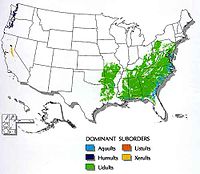 Map showing distribution and types of Ultisols throughout the United States; there is no Ultisol on the Ohio River flood plains, as the river has historically deposited other soil types there during its regular natural flooding.
 -
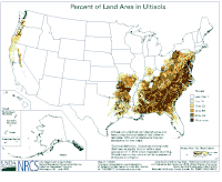 Map of the United States showing what percentage of the soil in a given area is classified as an Ultisol-type soil. The great majority of the land area classified in the highest category (75%-or-greater Ultisol) lies in the South and overlays with the Piedmont of the United States, which runs as a diagonal line through the South from southeast (in Alabama) to northwest (up through Virginia, and even into parts of Maryland).


Vertisols
[edit | edit source]
Vertisols are inverted soils, clay-rich with a tendency to swell when wet and shrink upon drying, often forming deep cracks into which surface layers can fall, difficult to farm or to construct roads and buildings due to their high expansion rate and constitute 2% of soils worldwide.
In both the World Reference Base for Soil Resources (WRB) and the USDA soil taxonomy, a Vertisol (Vertosol in the Australian Soil Classification) is a soil in which there is a high content of expansive clay minerals, many of them known as montmorillonite, that form deep cracks in drier seasons or years. In a phenomenon known as argillipedoturbation, alternate shrinking and swelling causes self-ploughing, where the soil material consistently mixes itself, causing some Vertisols to have an extremely deep A horizon and no B horizon. (A soil with no B horizon is called an A/C soil).[76]
Fossils
[edit | edit source]
"Microscopic shells in seafloor sediment collected from Blake Ridge. The large, round shell at the top left of the image is a planktonic pteropod about 0.25mm across. The triangular shell immediately underneath is a benthic, or bottom dwelling, foraminifer, Bolivina. All other larger shells, including the pink one (Gloobigerinoides), are planktonic foraminifers. The planktonic shells have fallen from the surface waters to the seafloor."[77]
Sediment cores
[edit | edit source]

Sediment cores may be obtained "by drilling or jack-hammering a steel rod or shoving a hand auger or hollow "push core" into a beach or marsh or water bottom, and pulling up sediment samples for analysis."[78]
"You can think of a sediment core as being more or less a tape recorder of time. Within that sediment core, we work with proxies, or environmental proxies, and these can be very simple measures of grain size or composition or some organic geochemical property or maybe pollen."[79]
"There are environments that preserve storm records that are buried in the sea bed, so that you can go down through time and actually develop a record of the intensity and frequency of cyclonic storms. That's something that's pretty high up on the radar for coastal inhabitants. Kind of understanding the pattern of these storms through time helps us to understand what might be coming down the pike."[79]
"You take a sediment core through a barrier island and under that is marsh, bay, marsh, mainland. You have maybe an old forest, roots. Looking back in time at that location, hundreds of thousands of years ago, you get this vertical succession of these different layers."[80]
Pleistocene
[edit | edit source]
The Pleistocene dates from 2.588 x 10⁶ to 11,700 b2k.
"The presence of tropical plant and animal remains at the polar latitudes indicate that significantly warmer conditions must have existed as compared to today. Conversely, the absence of tree pollen in the tundra probably means that conditions were too cold for trees to grow."[81]
"For more quantitative information you have to look in the oceans, and in particular, at the deep sediments that lie on the bottom of the seas. There, a steady rain of shells from small, surface-dwelling animals falls continually, eventually building up hundreds of meters of sediment. These sediments preserve the shells of these small animals for millions of years, all the way back to the age of the dinosaurs, 65 million years ago."[81]
"The most important of these animals, foraminifera (or forams for short), make their tiny shells from a form of calcium carbonate (CaCO3). This carbonate is found in many common geological features, such as the White Cliffs of Dover, which were once at the bottom of the sea."[81]
"The carbonate, originally dissolved in the oceans, contains oxygen, whose atoms exist in two naturally-occurring stable isotopes, 18O and 16O. The ratio of these two isotopes tells us about past temperatures. When the carbonate solidifies to form a shell, the isotopic ratio in the oxygen (written as δ18O) varies slightly depending on the temperature of the surrounding water. The change is only a tiny 0.2 parts per million decrease for each degree of temperature increase. Nevertheless, this is sufficient for us to be able to estimate the temperature of the water in which the forams lived millions of years ago. From this, we can see that temperatures in the Arctic Ocean were about 10-15°C warmer at the time of the dinosaurs than they are today!"[81]
"The δ18O value in the shells depends critically on what the δ18O value was in the surrounding sea water (H2O), and that can be as variable as the temperature! This variability arises because when water evaporates, the lighter molecules of water (those with 16O atoms as compared to those with 18O) tend to evaporate first. Therefore, water vapor is more depleted (fewer H218O molecules) than the ocean from which it evaporates. Thus, the ocean has more 18O in places where lots of water evaporates (like the sub-tropics) and less where it rains a lot (like the mid-latitudes)."[81]
"Similarly, when water vapor condenses (to make rain for instance), the heavier molecules (H218O) tend to condense and precipitate first. So, as water vapor makes its way poleward from the tropics, it gradually becomes more and more depleted in the heavier isotope. Consequently snow falling in Canada has much less H218O than rain falling in Florida. Changes in climate that alter the global patterns of evaporation or precipitation can therefore cause changes to the background δ18O ratio."[81]
"In addition, the great ice-sheets that once covered North America, consisting of snow falling in what is now Canada, were very depleted in 18O. Now, enough water was held in these ice sheets to reduce the global average sea level by about 120 m. Furthermore, there was also enough depleted water trapped in the ice to increase the average isotopic content of the oceans. And so the first thing we see when we analyze the shells from the bottom of the ocean, is the waxing and waning of the great ice sheets over the last 3 million years [in the figure on the right]. The same pattern over the last 400,000 years can also be seen in the isotopes measured in ice cores drilled from the remaining ice sheets in Greenland and Antarctica."[81]
Technology
[edit | edit source]
"A VIMS field crew [assembled in the image on the right] collects sediment cores on the landward side of the Plum Island barrier island in May 2014. These cores were collected with a Geoprobe drill rig [shown] and went as much as 60 feet below the surface of the island. Cores were collected in 4 feet sections and brought back to VIMS for processing."[82]
Hypotheses
[edit | edit source]- Sediment occurs from the action of rocky, liquid, gaseous, and plasma objects.
See also
[edit | edit source]- Agriculture (18 kB) (6 March 2020)
- Archaeology (75 kB) (6 March 2020)
- Astrogeology (58 kB) (19 January 2020)
- Astrognosy (47 kB) (14 February 2020)
- Callisto (47 kB) (7 December 2019)
- Ceres (33 kB) (6 December 2019)
- Comets (38 kB) (6 December 2019)
- Compositions (15 kB) (7 November 2019)
- Conditions (10 kB) (1 February 2020)
- Dione (21 kB) (27 October 2019)
- Distances (19 kB) (6 October 2019)
- Enceladus (46 kB) (8 October 2019)
- Gases (25 kB) (27 October 2019)
- Geochemistry (40 kB) (21 February 2020)
- Geochemistry to produce Widgiemoolthalite (56 kB) (13 March 2020)
- Geochronology (110 kB) (23 February 2020)
- Geographic coordinates (38 kB) (14 March 2020)
- Geomorphology (72 kB) (1 February 2020)
- Geophysics (88 kB) (19 January 2020)
- Geoseismology (36 kB) (8 December 2019)
- History (213 kB) (27 January 2020)
- Io (37 kB) (7 December 2019)
- Libyan history (30 kB) (1 February 2020)
- Liquids (39 kB) (11 February 2020)
- Measurements (5 kB) (12 December 2019)
- Metadefinitions (38 kB) (1 February 2020)
- Mining geology (28 kB) (11 February 2020)
- Moon (116 kB) (15 January 2020)
- North Sea continental shelves (112 kB) (11 February 2020)
- Oceanography (27 kB) (19 January 2020)
- Paleontology (119 kB) (21 January 2020)
- Petrophysics (43 kB) (7 November 2019)
- Planets (132 kB) (24 October 2019)
- Pluto (22 kB) (19 January 2020)
- Professional practice in architecture (7 kB) (21 February 2020)
- Reef geomorphology (28 kB) (22 February 2020)
- Regions (22 kB) (13 December 2019)
- Sedimentary rocks (57 kB) (14 February 2020)
- Sediments (60 kB) (17 March 2020)
- Solids (16 kB) (19 September 2019)
- South east African continental shelves (20 kB) (6 March 2020)
- Stratigraphy
- Structural geology (72 kB) (24 February 2020)
- Titan (51 kB) (25 October 2019)
- Venus (92 kB) (22 January 2020)
- Vesta (41 kB) (6 December 2019)
- Volcanoes (103 kB) (11 February 2020)
References
[edit | edit source]- ↑ Barry Eakins (2003). Total Sediment Thickness of the World's Oceans and Marginal Seas, Version 1. Boulder, CO USA: NOAA National Geophysical Data Center. http://www.ngdc.noaa.gov/mgg/sedthick/sedthick.html. Retrieved 2016-01-24.
- ↑ lithification. San Francisco, California: Wikimedia Foundation, Inc. 17 August 2013. https://en.wiktionary.org/wiki/lithification. Retrieved 2015-02-19.
- ↑ lithofacies. San Francisco, California: Wikimedia Foundation, Inc. 27 May 2014. https://en.wiktionary.org/wiki/lithofacies. Retrieved 2015-02-19.
- ↑ lithogenesis. San Francisco, California: Wikimedia Foundation, Inc. 26 May 2014. https://en.wiktionary.org/wiki/lithogenesis. Retrieved 2015-02-19.
- ↑ lithophile. San Francisco, California: Wikimedia Foundation, Inc. 2 April 2014. https://en.wiktionary.org/wiki/lithophile. Retrieved 2015-02-19.
- ↑ 6.0 6.1 James St. John (10 June 2012). Fantasy Canyon. Flickr. https://www.flickr.com/people/47445767@N05. Retrieved 2017-01-25.
- ↑ sediment. San Francisco, California: Wikimedia Foundation, Inc. 29 October 2014. https://en.wiktionary.org/wiki/sediment. Retrieved 2014-12-05.
- ↑ SemperBlotto (18 August 2006). sedimentology. San Francisco, California: Wikimedia Foundation, Inc. https://en.wiktionary.org/wiki/sedimentology. Retrieved 2014-11-09.
- ↑ erratic. San Francisco, California: Wikimedia Foundation, Inc. 13 August 2014. https://en.wiktionary.org/wiki/erratic. Retrieved 2014-12-05.
- ↑ regolith. San Francisco, California: Wikimedia Foundation, Inc. 25 May 2014. https://en.wiktionary.org/wiki/regolith. Retrieved 2014-12-05.
- ↑ 11.0 11.1 11.2 USGSTurbidites (July 24, 2012). Earthquake Glossary - turbidites. Menlo Park, California USA: USGS. http://earthquake.usgs.gov/learn/glossary/?term=turbidites. Retrieved 2014-12-02.
- ↑ L. J. G. Schermerhorn (September 1966). "Terminology of Mixed Coarse-Fine Sediments: NOTES". Journal of Sedimentary Petrology 36 (3): 831-5. http://archives.datapages.com/data/sepm/journals/v33-37/data/036/036003/0831.htm. Retrieved 2014-11-08.
- ↑ Henry R. Schmoll (2000). A Geologic Guide color version for web. National Park Service. https://www.nps.gov/wrst/learn/nature/upload/A-Geologic-Guide-color-version-for-web.pdf. Retrieved 2017-01-25.
- ↑ drift. San Francisco, California: Wikimedia Foundation, Inc. 18 October 2014. https://en.wiktionary.org/wiki/drift. Retrieved 2014-12-03.
- ↑ till. San Francisco, California: Wikimedia Foundation, Inc. 17 November 2014. https://en.wiktionary.org/wiki/till. Retrieved 2014-12-04.
- ↑ SemperBlotto (12 August 2005). alluvium. San Francisco, California: Wikimedia Foundation, Inc. https://en.wiktionary.org/wiki/alluvium. Retrieved 2014-11-10.
- ↑ outwash. San Francisco, California: Wikimedia Foundation, Inc. 17 April 2014. https://en.wiktionary.org/wiki/outwash. Retrieved 2014-12-05.
- ↑ 18.0 18.1 18.2 18.3 Eleyne Phillips (16 December 2004). Glossary of Glacier Terminology. Reston, Virginia USA: United States Geological Survey. http://pubs.usgs.gov/of/2004/1216/text.html#h. Retrieved 2014-11-09.
- ↑ František Marko, Daniel Pivko and Vratislav Hurai (2003). "Ruin marble: a record of fracture-controlled fluid flow and precipitation". Geological Quarterly 47 (3): 241-52. https://gq.pgi.gov.pl/article/download/7313/5963. Retrieved 2015-02-21.
- ↑ Liesegang rings. San Francisco, California: Wikimedia Foundation, Inc. 19 June 2013. https://en.wiktionary.org/wiki/Liesegang_rings. Retrieved 2015-02-21.
- ↑ SemperBlotto (31 March 2006). loess. San Francisco, California: Wikimedia Foundation, Inc. https://en.wiktionary.org/wiki/loess. Retrieved 2014-11-10.
- ↑ 22.0 22.1 22.2 "soil". San Francisco, California: Wikimedia Foundation, Inc. 25 November 2014. Retrieved 2014-12-05.
- ↑ 23.0 23.1 Natural Resources Conservation Service (5 December 2014). Port -- Oklahoma State Soil. Washington, DC USA: U. S. Department of Agriculture. http://www.nrcs.usda.gov/wps/PA_NRCSConsumption/download?cid=stelprdb1236986&ext=pdf. Retrieved 2014-12-05.
- ↑ Chesworth, Ward, ed (2008). Encyclopedia of soil science. Dordrecht, The Netherlands: Springer. ISBN 978-1-4020-3994-2. https://web.archive.org/web/20180905002957/http://www.encyclopedias.biz/dw/Encyclopedia%20of%20Soil%20Science.pdf. Retrieved 2019-01-14.
- ↑ Voroney, R. Paul; Heck, Richard J. (2007). "The soil habitat". In Paul, Eldor A.. Soil microbiology, ecology and biochemistry (3rd ed.). Amsterdam: Elsevier. pp. 25–49. doi:10.1016/B978-0-08-047514-1.50006-8. ISBN 978-0-12-546807-7. https://web.archive.org/web/20180710102532/http://csmi.issas.ac.cn/uploadfiles/Soil%20Microbiology%2C%20Ecology%20%26%20Biochemistry.pdf. Retrieved 2019-01-15.
- ↑ Danoff-Burg, James A. "The terrestrial influence: geology and soils". Earth Institute Center for Environmental Sustainability. New York: Columbia University Press. Retrieved 17 December 2017.
- ↑ Taylor, Sterling A.; Ashcroft, Gaylen L. (1972). Physical edaphology: the physics of irrigated and nonirrigated soils. San Francisco: W.H. Freeman. ISBN 978-0-7167-0818-6. https://archive.org/details/physicaledapholo0000tayl.
- ↑ McCarthy, David F. (2006). Essentials of soil mechanics and foundations: basic geotechnics (7th ed.). Upper Saddle River, New Jersey: Prentice Hall. ISBN 978-0-13-114560-3.
- ↑ Gilluly, James; Waters, Aaron Clement; Woodford, Alfred Oswald (1975). Principles of geology (4th ed.). San Francisco: W.H. Freeman. ISBN 978-0-7167-0269-6.
- ↑ Ponge, Jean-François (2015). "The soil as an ecosystem". Biology and Fertility of Soils 51 (6): 645–48. doi:10.1007/s00374-015-1016-1. https://www.researchgate.net/publication/276090499. Retrieved 17 December 2017.
- ↑ "Glossary of Terms in Soil Science". Agriculture and Agri-Food Canada. Retrieved 2019-01-15.
- ↑ Amundson, Ronald. "Soil preservation and the future of pedology" (PDF). Faculty of Natural Resources. Songkhla, Thailand: Prince of Songkla University. Retrieved 2019-01-15.
- ↑ Küppers, Michael; Vincent, Jean-Baptiste. "Impacts and formation of regolith". Max Planck Institute for Solar System Research. Retrieved 2019-01-15.
- ↑ IUSS Working Group WRB (2015). "World Reference Base for Soil Resources 2014, Update 2015" (PDF). World Soil Resources Reports 106, FAO, Rome.
- ↑ "Andisols". National Resource Conservation Service. United States Department of Agriculture. Retrieved 2006-05-14.
- ↑ IUSS Working Group WRB (2015). "World Reference Base for Soil Resources 2014, Update 2015" (PDF). World Soil Resources Reports 106, FAO, Rome.
- ↑ Grunwald, Sabine. "Andisols". Soil & Water Sciences. University of Florida. Retrieved 2006-05-14.
- ↑ "Andisols". Soil and Land Sciences Division. University of Idaho. Retrieved 2006-05-14.
- ↑ 39.0 39.1 "Aridisols". USDA-NRCS. Retrieved 2006-05-14.
- ↑ IUSS Working Group WRB (2015). "World Reference Base for Soil Resources 2014, Update 2015" (PDF). World Soil Resources Reports 106, FAO, Rome.
- ↑ IUSS Working Group WRB (2015). "World Reference Base for Soil Resources 2014, Update 2015" (PDF). World Soil Resources Reports 106, FAO, Rome.
- ↑ IUSS Working Group WRB (2015). "World Reference Base for Soil Resources 2014, Update 2015" (PDF). World Soil Resources Reports 106, FAO, Rome.
- ↑ "Hydric Soils of Florida". Wetland Evaluation and Delineation Program. Florida Department of Environmental Protection.
- ↑ "Australian Soil Classification - Organosols". CSIRO. Retrieved 8 February 2016.
- ↑ "Inceptisols" (PDF). USDA-NRCS. Retrieved 2014-11-06.
- ↑ "Inceptisols". University of Florida. Retrieved 2006-05-14.
- ↑ "Inceptisols". University of Idaho. Retrieved 2006-05-14.
- ↑ IUSS Working Group WRB (2015). "World Reference Base for Soil Resources 2014, Update 2015" (PDF). World Soil Resources Reports 106, FAO, Rome.
- ↑ intraclast. San Francisco, California: Wikimedia Foundation, Inc. 21 June 2013. https://en.wiktionary.org/wiki/intraclast. Retrieved 2015-02-15.
- ↑ "Mollisols". USDA-NRCS. Retrieved 2006-05-14.
- ↑ "Mollisols". University of Florida. Retrieved 2006-05-14.
- ↑ "Mollisols". University of Idaho. Retrieved 2006-05-14.
- ↑ "Oxisols". USDA-NRCS. Retrieved 2006-05-14.
- ↑ IUSS Working Group WRB (2015). "World Reference Base for Soil Resources 2014, Update 2015" (PDF). World Soil Resources Reports 106, FAO, Rome.
- ↑ Lofjle, E.; Kubiniok, J. Landform development and bioturbation on the Khorat plateau, Northeast Thailand, Nat.Hist.Bull.Siam Soc. (56), 1996 "Archived copy" (PDF). Retrieved 2010-12-23.
- ↑ "laterite". San Francisco, California: Wikimedia Foundation, Inc. 24 May 2014. Retrieved 2014-12-05.
- ↑ Chesworth, W. (Eds.), 2008. Encyclopedia of soil science, The Netherlands.
- ↑ Spaargaren, Otto. Podzols. Encyclopedia of Soil Science, pp. 580–581.
- ↑ Gerding, Victor; Thiers, Oscar (2002). "Characterization of soils of Nothofagus betuloides (Mirb) Blume forests, in Tierra del Fuego, Chile". Revista chilena de historia natural 75 (4): 819–833. doi:10.4067/S0716-078X2002000400015. http://www.scielo.cl/scielo.php?pid=S0716-078X2002000400015&script=sci_arttext.
- ↑ 60.0 60.1 C., Park, Chris. A dictionary of environment and conservation. Allaby, Michael (3rd ed.). [Oxford]. ISBN 9780191826320. OCLC 970401188.
- ↑ 61.0 61.1 61.2 61.3 61.4 61.5 Fritz., Scheffer (2010). Lehrbuch der Bodenkunde. Schachtschabel, Paul., Blume, Hans-Peter (16. Aufl ed.). Heidelberg: Spektrum, Akad. Verl. ISBN 9783827414441. OCLC 506415938.
- ↑ 62.0 62.1 62.2 62.3 62.4 Lundström, U.S; Van Breemen, N.; Bain, D. (2000-02-01). "The podzolization process. A review". Geoderma 94 (2–4): 91–107. doi:10.1016/S0016-7061(99)00036-1. ISSN 0016-7061.
- ↑ 63.0 63.1 63.2 Sanborn, Paul; Lamontagne, Luc; Hendershot, William (2011-01-01). "Podzolic soils of Canada: Genesis, distribution, and classification". Canadian Journal of Soil Science 91 (5): 843–880. doi:10.4141/cjss10024. ISSN 0008-4271.
- ↑ Buurman, P.; Jongmans, A.G. (2005-03-01). "Podzolisation and soil organic matter dynamics". Geoderma 125 (1–2): 71–83. doi:10.1016/j.geoderma.2004.07.006. ISSN 0016-7061.
- ↑ Fekiacova, Z.; Vermeire, M.L.; Bechon, L.; Cornelis, J.T.; Cornu, S. (2017-06-15). "Can Fe isotope fractionations trace the pedogenetic mechanisms involved in podzolization?". Geoderma 296: 38–46. doi:10.1016/j.geoderma.2017.02.020. ISSN 0016-7061. http://orbi.ulg.ac.be/handle/2268/212632.
- ↑ IUSS Working Group WRB (2015). "World Reference Base for Soil Resources 2014, Update 2015" (PDF). World Soil Resources Reports 106, FAO, Rome.
- ↑ Keys to Soil Taxonomy 2014
- ↑ Institute of Soil Science, Chinese Academy of Sciences (2001). Chinese Soil Taxonomy. Science Press, Beijing, New York.
- ↑ "Spodosols". geo.msu.edu. Retrieved 2018-05-04.
- ↑ "Podzolic - Soils of Canada". www.soilsofcanada.ca. Retrieved 2018-05-07.
- ↑ Canadian Agricultural Services Coordinating Committee. Soil Classification Working Group (1998). The Canadian system of soil classification (3rd ed.). Ottawa: NRC Research Press. ISBN 978-0585119052. OCLC 44961488.
- ↑ R.F. Isbell and the National Committee on Soil and Terrain (2016). "Australian Soil Classification, second edition (as Online Interactive Key)". CSIRO. Retrieved 11 February 2016.
- ↑ dos Santos, Humberto Gonçalves (2018). Sistema Brasileira de Classificação de Solos, quinta edição. Embrapa, Brasilia.
- ↑ IUSS Working Group WRB (2015). "World Reference Base for Soil Resources 2014, Update 2015" (PDF). World Soil Resources Reports 106, FAO, Rome.
- ↑ Vitousek, P. M., and Sanford Jr., R. L. (1985). Nutrient cycling in moist tropical forest. Annual Review of Ecology and Systematics, 17, 137-167. https://www.jstor.org/stable/2096992
- ↑ "Australian Soil Classification - Vertosols". CSIRO. Retrieved 8 February 2016.
- ↑ Nathalie Valette-Silver (27 September 2001). Microscopic shells in sea floor sediment. NOAA/OER. http://oceanexplorer.noaa.gov/explorations/deepeast01/logs/sep27/media/forams.html. Retrieved 2016-01-24.
- ↑ Tamara Dietrich (1 January 2015). VIMS geologists use sediment cores as a window to the past. DailyPress. http://touch.dailypress.com/#section/-1/article/p2p-82439684/. Retrieved 2015-01-12.
- ↑ 79.0 79.1 Steve Kuehl (1 January 2015). VIMS geologists use sediment cores as a window to the past. DailyPress. http://touch.dailypress.com/#section/-1/article/p2p-82439684/. Retrieved 2015-01-12.
- ↑ Christopher Hein (1 January 2015). VIMS geologists use sediment cores as a window to the past. DailyPress. http://touch.dailypress.com/#section/-1/article/p2p-82439684/. Retrieved 2015-01-12.
- ↑ 81.0 81.1 81.2 81.3 81.4 81.5 81.6 Gavin Schmidt (January 1999). Cold Climates, Warm Climates: How Can We Tell Past Temperatures?. Washington, DC USA: NASA. http://www.giss.nasa.gov/research/briefs/schmidt_01/. Retrieved 2016-01-24.
- ↑ Joe Fudge (31 December 2014). Pictures: VIMS studies sediment core samples. Virginia: DailyPress. http://touch.dailypress.com/#section/-1/gallery/p2p-82432981/?related=true. Retrieved 2015-01-12.
External links
[edit | edit source]
Learn more about Sediments |