Frévillers is a commune in the Pas-de-Calais department in the Hauts-de-France region of France.[3]
Frévillers | |
|---|---|
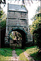
 Entrance to St. Anne’s church | |
 Coat of arms | |
Location of Frévillers  | |
 Frévillers  Frévillers | |
| Coordinates: 50°23′50″N 2°31′25″E / 50.3972°N 2.5236°E | |
| Country | France |
| Region | Hauts-de-France |
| Department | Pas-de-Calais |
| Arrondissement | Arras |
| Canton | Avesnes-le-Comte |
| Intercommunality | CC Campagnes de l'Artois |
| Government | |
| • Mayor (2020–2026) | Guy Vasseur[1] |
| Area 1 | 5.07 km2 (1.96 sq mi) |
| Population (2021)[2] | 240 |
| • Density | 47/km2 (120/sq mi) |
| Time zone | UTC+01:00 (CET) |
| • Summer (DST) | UTC+02:00 (CEST) |
| INSEE/Postal code | 62362 /62127 |
| Elevation | 141–187 m (463–614 ft) (avg. 172 m or 564 ft) |
| 1 French Land Register data, which excludes lakes, ponds, glaciers > 1 km2 (0.386 sq mi or 247 acres) and river estuaries. | |
Geography
editA farming village situated at the highest point in the département, 16 miles (26 km) northwest of Arras, at the junction of the D72 and the D74 roads.
Population
edit| Year | Pop. | ±% p.a. |
|---|---|---|
| 1968 | 235 | — |
| 1975 | 231 | −0.24% |
| 1982 | 226 | −0.31% |
| 1990 | 232 | +0.33% |
| 1999 | 253 | +0.97% |
| 2007 | 242 | −0.55% |
| 2012 | 250 | +0.65% |
| 2017 | 239 | −0.90% |
| Source: INSEE[4] | ||
Places of interest
edit- The church of St. Anne, dating from the eighteenth century.
- Vestiges of an old castle.
See also
editReferences
edit- ^ "Répertoire national des élus: les maires". data.gouv.fr, Plateforme ouverte des données publiques françaises (in French). 2 December 2020.
- ^ "Populations légales 2021" (in French). The National Institute of Statistics and Economic Studies. 28 December 2023.
- ^ INSEE commune file
- ^ Population en historique depuis 1968, INSEE
Wikimedia Commons has media related to Frévillers.
-
 The old gatehouse
 -
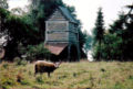 Sheep and the gatehouse


This Arras arrondissement, Pas-de-Calais geographical article is a stub. You can help Wikipedia by expanding it. |