| dbo:PopulatedPlace/area
| |
| dbo:PopulatedPlace/areaTotal
| |
| dbo:abstract
|
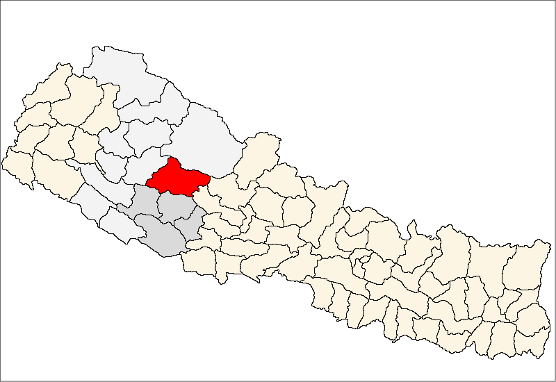
- Der Distrikt Rukum (Nepali रुकुम जिल्ला Rukum Jillā) war bis 2015 einer von 75 Distrikten in Nepal. Er lag in der ehemaligen Verwaltungszone Rapti südlich des westlichen Dhaulagiri Himal und wird von dem Fluss Sani Bheri in westlicher Richtung durchflossen. Verwaltungssitz war Musikot. Nach der Neustrukturierung des Landes durch die Verfassung von 2015 mit der Umwandlung Nepals in eine Bundesrepublik wurde der Distrikt auf die neu geschaffenen Provinzen Lumbini (östlicher Teil) und Karnali (westlicher Teil) aufgeteilt. Entsprechend der Verfassung tragen die neuen Distrikte die Namen und Rukum West. (de)
- Le district de Rukum – en népalais : रुकुम जिल्ला – était l'un des 75 districts du Népal, rattaché à la zone de Rapti et à la région de développement Moyen-Ouest. La population du district s'élevait à 208 567 habitants en 2011. À la suite de la création des provinces introduite par la constitution népalaise de 2015, le district fut séparé en deux :
* Rukum-Est rattaché à la province de Lumbini
* Rukum-Ouest rattaché à la province de Karnali (fr)
- Rukum District (Nepali: रुकुम जिल्ला) was a "hill" and "mountain" district some 280 km (170 mi) west of Kathmandu partially belonging to Lumbini Province and partially to Karnali Province before split into two districts Western Rukum and Eastern Rukum after the state's reconstruction of administrative divisions in 2017. Rukum covers an area of 2,877 km2 (1,111 sq mi) with population of 207,290 in 2011 Nepal census. Musikot (also called Jhumlikhalanga) was the district's administrative center. Rukum district has potential tourist attractions that remain largely unexplored including yarsagumba (Ophiocordyceps sinensis) collection caravan destinations, historical sites from the ten-year insurrection including the seat of a breakaway government in Banphikot, eastern Rukum, and the so-called Guerrilla Trek passes through this area that was a hotbed for recruiting and training as well as a battleground during Nepal's civil war (1996-2006). (. There is 5,911 metres (19,393 ft) Mt. Sisne (Nepali: सिस्ने हिमाल), the westernmost high peak in the Dhaulagiri massif. Locals refer to Sisne as Hiunchuli (hiu: snow; chuli: top) and it is considered sacred as the abode of deities Masta and Saikumari. Climbing history on the mountain is not well documented and an eight-man expedition led by Man Bahadur Khatri reached the summit ridge in May 2013. Rukumkot, a prominent village in Rukum is referred to as "the place of 52 lakes and 53 hills". Rukumkot (Nepali: all of them Shyarpu Tal (Lake) is largest lake in Rukum रुकुमकोट) has a beautiful pond called Rukmini Tal or locally Kamal Dhaha for its lotus flowers (kamal: lotus). Nearby are notable temples called Barah and Sibalaya, and caves such as Deurali Cave. (en)
- Il distretto di Rukum era un distretto del Nepal di 188.438 abitanti, che ha come capoluogo Musikot Khalanga. In seguito alle riforme del 2015 è stato soppresso e diviso nei distretti di Rukum Est e Rukum Ovest. Il distretto faceva parte della zona di Rapti nella Regione del Medio Occidente. Il suo territorio è ora suddiviso tra la Provincia No. 5 e il Karnali Pradesh. Il territorio è suddiviso in 43 Comitati per lo sviluppo dei villaggi (VDC). Geograficamente il distretto appartiene alla zona collinare della . Nella parte occidentale, a segnare il confine con il distretto di Jajarkot scorre il fiume , affluente del Karnali (o Ghaghara).Nella zona est si trova la . Al centro la valle del , affluente di sinistra del Thuli Bheri. Nel distretto vi è una forte presenza del gruppo etnico Magar, che dopo i Chhetri costituisce il secondo gruppo per popolazione. (it)
- ルクム郡(ネパール語: रुकुम जिल्ला)は、かつて存在したネパールの郡。廃止時は郡東部が第五州(現在のルンビニ州)、郡西部が第六州(現在のカルナリ州)に属していた。郡都は。 面積は2,877平方キロメートル、人口は208,567人(2011年国勢調査)。先住民族のカム・マガール族が住む。 (ja)
- Rukum (Nepalees: रुकुम) is een van de 75 districten van Nepal. Het district is gelegen in de Rapti-zone en de hoofdplaats is Musikot Khalanga. (nl)
- Rukum é um distrito da zona de Rapti, no Nepal. (pt)
- Dystrykt Rukum (nep. रुकुम) – jeden z siedemdziesięciu pięciu dystryktów Nepalu. Leży w strefie Rapti. Dystrykt ten zajmuje powierzchnię 2877 km², w 2001 r. zamieszkiwało go 188 438 ludzi. Stolicą jest Musikot. (pl)
- Рукум (непальск. रुकुम जिल्ला) — один из 75 районов Непала. Входит в состав зоны Рапти, которая, в свою очередь, входит в состав Среднезападного региона страны. Административный центр — город Мусикот. Граничит с районами Сальян и Ролпа (на юге), районами Баглунг и Мьягди зоны Дхаулагири (на востоке), районом Долпа зоны Карнали (на севере) и районом Джаяркот зоны Бхери (на западе). Площадь района составляет 2877 км². Высота территории изменяется от около 800 до 5911 м над уровнем моря. Район находится в бассейне реки Бхери, крупнейшего притока река Карнали. Население по данным переписи 2011 года составляет 208 567 человек, из них 99 159 мужчин и 109 408 женщин. По данным переписи 2001 года население насчитывало 188 438 человек. 96,51 % населения исповедуют индуизм; 1,59 % — христианство; 1,07 % — буддизм; 0,06 % — ислам. (ru)
|
| dbo:area
| |
| dbo:areaTotal
|
- 2877000000.000000 (xsd:double)
|
| dbo:country
| |
| dbo:governingBody
| |
| dbo:governmentType
| |
| dbo:politicalLeader
| |
| dbo:populationTotal
|
- 207290 (xsd:nonNegativeInteger)
|
| dbo:thumbnail
| |
| dbo:timeZone
| |
| dbo:utcOffset
| |
| dbo:wikiPageExternalLink
| |
| dbo:wikiPageID
| |
| dbo:wikiPageLength
|
- 16856 (xsd:nonNegativeInteger)
|
| dbo:wikiPageRevisionID
| |
| dbo:wikiPageWikiLink
|
- dbr:Aathbis_Danda
- dbr:Aathbis_Kot
- dbr:Provinces_of_Nepal
- dbr:Provincial_Assembly_(Nepal)
- dbr:Purtim_Kanda
- dbr:Pwang
- dbr:Pyaugha
- dbr:Rugha
- dbr:Rukum_Salle_Airport
- dbr:Rukumkot
- dbr:2011_Nepal_census
- dbr:Bhalakachha
- dbr:Bheri_River
- dbr:House_of_Representatives_(Nepal)
- dbr:Hukam,_Nepal
- dbr:List_of_sovereign_states
- dbr:Nepalganj
- dbr:Chunwang
- dbr:Garayala
- dbr:Geography_of_Nepal
- dbr:Ghetma
- dbr:Government_of_Nepal
- dbr:Ministry_for_Foreign_Affairs_(Finland)
- dbr:Morawang
- dbr:Muru,_Nepal
- dbc:Rukum_District
- dbr:Rolpa_district
- dbr:Local_self-government_in_Nepal
- dbr:Lumbini_Province
- dbr:Lumbini_Zone
- dbr:Magar_language
- dbr:Magma,_Nepal
- dbr:Mahendra_Highway
- dbr:Simli
- dbr:Sisne
- dbc:Former_districts_of_Nepal
- dbr:Gautamkot
- dbr:Pokhara,_Rapti
- dbr:Baitadi_District
- dbr:Banphikot
- dbr:Tribhuvan_International_Airport
- dbr:Western_Rukum_District
- dbr:Karnali_River
- dbr:Duli,_Nepal
- dbr:Eastern_Rukum_District
- dbr:Himalaya
- dbr:Jang,_Nepal
- dbr:Taksera
- dbr:Mahat,_Rapti
- dbr:Arma,_Nepal
- dbc:Districts_of_Nepal_established_in_1962
- dbr:Chaurjahari
- dbr:Chaurjahari_Airport
- dbr:Chhiwang
- dbr:Chokhawang
- dbr:Jhula
- dbr:Kankri
- dbr:Karnali_Province
- dbr:Kathmandu
- dbr:Kham_language
- dbr:Khara,_Nepal
- dbr:Languages_of_Nepal
- dbr:Syalapakha
- dbr:Montane_ecology
- dbr:Dhaulagiri
- dbr:Dhorpatan
- dbr:District_Coordination_Committee
- dbr:Pipal,_Nepal
- dbr:Kol,_Nepal
- dbr:Kotjahari
- dbr:Nepalese_Civil_War
- dbr:Nepalgunj_Airport
- dbr:Nepali_language
- dbr:Rangsi,_Rukum
- dbr:Ranmamekot
- dbr:Rapti_Zone
- dbr:Salyan,_Nepal
- dbr:Tulsipur,_Rapti
- dbr:Kanda,_Rapti
- dbr:Snow_line
- dbr:Kholagaun,_Rapti
- dbr:Subtropics
- dbr:Roads_in_Nepal
- dbr:Temperate_climate
- dbr:Tropical_climate
- dbr:Musikot,_Rukum
- dbr:Nepal_Time
- dbr:Musikot_Khalanga
- dbr:Nuwakot,_Rapti
- dbr:Topographic_maps
- dbr:Finland's
- dbr:Syalagadi
- dbr:Districts_of_Nepal
- dbr:Map_scale
- dbr:Communist_Party_of_Nepal_(Maoist)_(1994)
- dbr:File:Alonzo-lyons-emerald-paddy-Rukum-IMG_7825.jpg
- dbr:File:NepalRukumDistrictmap.png
- dbr:File:Sheep_Rearing_in_remote_village_of_Nepal.jpg
- dbr:File:Sisne-summit-ridge-alonzo-lyons-DSCN8458.jpg
- dbr:Sankha
|
| dbp:areaCodeType
| |
| dbp:areaMagnitude
| |
| dbp:areaTotalKm
| |
| dbp:blankNameSec
| |
| dbp:establishedTitle
| |
| dbp:governingBody
|
- DCC, Rukum District (en)
- रुकुम जिल्ला (en)
|
| dbp:governmentType
| |
| dbp:id
| |
| dbp:imageMap
|
- Rukum district location.png (en)
|
| dbp:leaderTitle
| |
| dbp:name
|
- Rukum District (en)
- रुकुम जिल्ला District (en)
|
| dbp:partsStyle
| |
| dbp:partsType
| |
| dbp:populationAsOf
| |
| dbp:populationDensityKm
| |
| dbp:populationTotal
| |
| dbp:postalCodeType
| |
| dbp:seat
| |
| dbp:seatType
| |
| dbp:subdivisionType
| |
| dbp:timezone
| |
| dbp:title
| |
| dbp:type
| |
| dbp:utcOffset
| |
| dbp:website
| |
| dbp:wikiPageUsesTemplate
| |
| dcterms:subject
| |
| gold:hypernym
| |
| schema:sameAs
| |
| georss:point
| |
| rdf:type
| |
| rdfs:comment
|
- Le district de Rukum – en népalais : रुकुम जिल्ला – était l'un des 75 districts du Népal, rattaché à la zone de Rapti et à la région de développement Moyen-Ouest. La population du district s'élevait à 208 567 habitants en 2011. À la suite de la création des provinces introduite par la constitution népalaise de 2015, le district fut séparé en deux :
* Rukum-Est rattaché à la province de Lumbini
* Rukum-Ouest rattaché à la province de Karnali (fr)
- ルクム郡(ネパール語: रुकुम जिल्ला)は、かつて存在したネパールの郡。廃止時は郡東部が第五州(現在のルンビニ州)、郡西部が第六州(現在のカルナリ州)に属していた。郡都は。 面積は2,877平方キロメートル、人口は208,567人(2011年国勢調査)。先住民族のカム・マガール族が住む。 (ja)
- Rukum (Nepalees: रुकुम) is een van de 75 districten van Nepal. Het district is gelegen in de Rapti-zone en de hoofdplaats is Musikot Khalanga. (nl)
- Rukum é um distrito da zona de Rapti, no Nepal. (pt)
- Dystrykt Rukum (nep. रुकुम) – jeden z siedemdziesięciu pięciu dystryktów Nepalu. Leży w strefie Rapti. Dystrykt ten zajmuje powierzchnię 2877 km², w 2001 r. zamieszkiwało go 188 438 ludzi. Stolicą jest Musikot. (pl)
- Der Distrikt Rukum (Nepali रुकुम जिल्ला Rukum Jillā) war bis 2015 einer von 75 Distrikten in Nepal. Er lag in der ehemaligen Verwaltungszone Rapti südlich des westlichen Dhaulagiri Himal und wird von dem Fluss Sani Bheri in westlicher Richtung durchflossen. Verwaltungssitz war Musikot. (de)
- Rukum District (Nepali: रुकुम जिल्ला) was a "hill" and "mountain" district some 280 km (170 mi) west of Kathmandu partially belonging to Lumbini Province and partially to Karnali Province before split into two districts Western Rukum and Eastern Rukum after the state's reconstruction of administrative divisions in 2017. Rukum covers an area of 2,877 km2 (1,111 sq mi) with population of 207,290 in 2011 Nepal census. Musikot (also called Jhumlikhalanga) was the district's administrative center. (en)
- Il distretto di Rukum era un distretto del Nepal di 188.438 abitanti, che ha come capoluogo Musikot Khalanga. In seguito alle riforme del 2015 è stato soppresso e diviso nei distretti di Rukum Est e Rukum Ovest. Il distretto faceva parte della zona di Rapti nella Regione del Medio Occidente. Il suo territorio è ora suddiviso tra la Provincia No. 5 e il Karnali Pradesh. Il territorio è suddiviso in 43 Comitati per lo sviluppo dei villaggi (VDC). Nel distretto vi è una forte presenza del gruppo etnico Magar, che dopo i Chhetri costituisce il secondo gruppo per popolazione. (it)
- Рукум (непальск. रुकुम जिल्ला) — один из 75 районов Непала. Входит в состав зоны Рапти, которая, в свою очередь, входит в состав Среднезападного региона страны. Административный центр — город Мусикот. Граничит с районами Сальян и Ролпа (на юге), районами Баглунг и Мьягди зоны Дхаулагири (на востоке), районом Долпа зоны Карнали (на севере) и районом Джаяркот зоны Бхери (на западе). Площадь района составляет 2877 км². Высота территории изменяется от около 800 до 5911 м над уровнем моря. Район находится в бассейне реки Бхери, крупнейшего притока река Карнали. (ru)
|
| rdfs:label
|
- Rukum District (en)
- Rukum (de)
- District de Rukum (fr)
- Distretto di Rukum (it)
- ルクム郡 (ja)
- Rukum (district) (nl)
- Rukum (dystrykt) (pl)
- Rukum (distrito) (pt)
- Рукум (район) (ru)
|
| owl:sameAs
| |
| geo:geometry
|
- POINT(82.466697692871 28.63330078125)
|
| geo:lat
| |
| geo:long
| |
| prov:wasDerivedFrom
| |
| foaf:depiction
| |
| foaf:homepage
| |
| foaf:isPrimaryTopicOf
| |
| foaf:name
|
- Rukum District (en)
- रुकुम जिल्ला District (en)
|
| is dbo:birthPlace
of | |
| is dbo:place
of | |
| is dbo:subdivision
of | |
| is dbo:wikiPageRedirects
of | |
| is dbo:wikiPageWikiLink
of | |
| is dbp:birthPlace
of | |
| is dbp:district
of | |
| is dbp:place
of | |
| is dbp:subdivisionName
of | |
| is foaf:primaryTopic
of | |


