| dbo:abstract
|
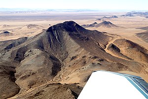
- Der Höchster (englisch Highest) ist ein Berg im Tsau-ǁKhaeb-(Sperrgebiet)-Nationalpark (ehemals Diamantensperrgebiet) im Südwesten Namibias. Er erreicht eine Höhe von 1114 m. Die Ausdehnung ist etwa 4 km × 4 km. Westlich des Höchster befinden sich die Klinghardtberge. Der durchschnittliche jährliche Niederschlag in diesem Teil der Namib beträgt nur wenige Millimeter. Die im Massiv vorkommenden Büsche überleben nur dank des Nebels, der sich von Zeit zu Zeit über dem kalten Atlantik bildet und tagsüber weit ins Landesinnere driftet. Die einzelnen Kameldornbäume beziehen ihr Wasser aus tiefen unterirdischen Wasseransammlungen. (de)
- Höchster ("The Highest") is a mountain in the Diamond Restricted Aerea, also called Sperrgebiet, in the southwestern part of Namibia. It reaches a height of 1,070 m. Its expansion is about 5 km × 4 km. West of Höchster are the Klinghardt Mountains. Several places of the mountain range are covered with sand which is blown over by sandstorms. The average yearly rainfall in this area of the Namib amounts to just a few millimeters. The bushes to be found in the mountains just survive because of the mist, which sometimes is formed above the cold Atlantic and then during daytime drifts far into the desert. The few Camel Thorn trees take their water from deep underground accumulations. (en)
|
| dbo:country
| |
| dbo:elevation
| |
| dbo:thumbnail
| |
| dbo:wikiPageID
| |
| dbo:wikiPageLength
|
- 2805 (xsd:nonNegativeInteger)
|
| dbo:wikiPageRevisionID
| |
| dbo:wikiPageWikiLink
| |
| dbp:country
| |
| dbp:elevationM
| |
| dbp:mapCaption
| |
| dbp:name
| |
| dbp:photo
|
- Höchster aerial view 2018.jpg (en)
|
| dbp:photoCaption
|
- Aerial view of Höchster in the Diamond Restricted Area (en)
|
| dbp:photoSize
| |
| dbp:subdivision
| |
| dbp:subdivision2Type
| |
| dbp:wikiPageUsesTemplate
| |
| dcterms:subject
| |
| georss:point
|
- -27.306666666666665 15.824166666666667
|
| rdf:type
| |
| rdfs:comment
|
- Der Höchster (englisch Highest) ist ein Berg im Tsau-ǁKhaeb-(Sperrgebiet)-Nationalpark (ehemals Diamantensperrgebiet) im Südwesten Namibias. Er erreicht eine Höhe von 1114 m. Die Ausdehnung ist etwa 4 km × 4 km. Westlich des Höchster befinden sich die Klinghardtberge. (de)
- Höchster ("The Highest") is a mountain in the Diamond Restricted Aerea, also called Sperrgebiet, in the southwestern part of Namibia. It reaches a height of 1,070 m. Its expansion is about 5 km × 4 km. West of Höchster are the Klinghardt Mountains. Several places of the mountain range are covered with sand which is blown over by sandstorms. The average yearly rainfall in this area of the Namib amounts to just a few millimeters. (en)
|
| rdfs:label
|
- Höchster (de)
- Höchster (en)
|
| owl:sameAs
| |
| geo:geometry
|
- POINT(15.824166297913 -27.306667327881)
|
| geo:lat
| |
| geo:long
| |
| prov:wasDerivedFrom
| |
| foaf:depiction
| |
| foaf:isPrimaryTopicOf
| |
| foaf:name
| |
| is dbo:wikiPageWikiLink
of | |
| is rdfs:seeAlso
of | |
| is foaf:primaryTopic
of | |


