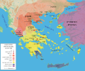
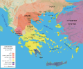
File:Map Macedonia 336 BC-es.svg

Original file (SVG file, nominally 992 × 794 pixels, file size: 3.41 MB)
Captions
Captions
| DescriptionMap Macedonia 336 BC-es.svg |
Español: Mapa del reino de Filipo II a su muerte, 336 adC |
||||||||
| Date | |||||||||
| Source |
Own work using Adobe Illustrator (data from R. Ginouvès and al., La Macédoine, Paris, 1992). Translated from Image:Map Macedonia 336 BC-fr.svg.
|
||||||||
| Author | Marsyas; Kordas | ||||||||
| Permission (Reusing this file) |
I, the copyright holder of this work, hereby publish it under the following licenses:
This file is licensed under the Creative Commons Attribution-Share Alike 2.5 Generic license.
You may select the license of your choice. |
||||||||
| Other versions |
[edit]
|
| This SVG file contains embedded text that can be translated into your language, using any capable SVG editor, text editor or the SVG Translate tool. For more information see: About translating SVG files. |
File history
Click on a date/time to view the file as it appeared at that time.
| Date/Time | Thumbnail | Dimensions | User | Comment | |
|---|---|---|---|---|---|
| current | 22:24, 27 June 2007 |  | 992 × 794 (3.41 MB) | Bibi Saint-Pol (talk | contribs) | fix several SVG problems; restore legend: this is part of the map |
| 08:11, 20 March 2017 |  | 1,058 × 847 (4.07 MB) | Rowanwindwhistler (talk | contribs) | https://en.wikipedia.org/wiki/Wikipedia:WikiProject_Maps/Conventions Fake text added | |
| 07:36, 25 February 2016 |  | 992 × 794 (3.59 MB) | Rowanwindwhistler (talk | contribs) | Cleaner version, height per layer for easier modification, duplication of islands removed. | |
| 06:56, 25 February 2016 |  | 992 × 794 (3.06 MB) | Rowanwindwhistler (talk | contribs) | Battle symbols on top | |
| 09:28, 22 February 2016 |  | 992 × 794 (3.06 MB) | Rowanwindwhistler (talk | contribs) | Eubea corrected | |
| 19:20, 29 December 2015 |  | 992 × 794 (3.06 MB) | Rowanwindwhistler (talk | contribs) | No transparency for the sea | |
| 19:17, 29 December 2015 |  | 992 × 794 (3.06 MB) | Rowanwindwhistler (talk | contribs) | Coast added, sea colour changed as per https://en.wikipedia.org/wiki/Wikipedia:WikiProject_Maps/Conventions | |
| 22:29, 27 June 2007 |  | 992 × 794 (3.41 MB) | Bibi Saint-Pol (talk | contribs) | {{Information |Description= {{es|Mapa del reino de Filipo II a su muerte, 336 adC}} Source=Own work using Adobe Illustrator (data from R. Ginouvès and al., ''La Macédoine'', Paris, 1992). Translated from [[:Image:Map Macedonia 336 | |
| 23:54, 13 June 2007 |  | 993 × 794 (3.43 MB) | Ignacio Icke (talk | contribs) | -legend off | |
| 23:29, 12 June 2007 |  | 993 × 794 (3.43 MB) | Ignacio Icke (talk | contribs) | trying to solve the rectangles thing |
You cannot overwrite this file.
File usage on Commons
The following 19 pages use this file:
- File:Karte Makedonien 336 vC-de.svg
- File:Macedonia y Grecia (336 adC).svg (file redirect)
- File:Map Macedonia 336 BC-ar.svg
- File:Map Macedonia 336 BC-bg.svg
- File:Map Macedonia 336 BC-ca.svg
- File:Map Macedonia 336 BC-ce.svg
- File:Map Macedonia 336 BC-de.svg
- File:Map Macedonia 336 BC-en.svg
- File:Map Macedonia 336 BC-es.svg
- File:Map Macedonia 336 BC-fr.svg
- File:Map Macedonia 336 BC-he-2.svg
- File:Map Macedonia 336 BC-he.svg
- File:Map Macedonia 336 BC-it.svg
- File:Map Macedonia 336 BC-ka.svg
- File:Map Macedonia 336 BC-pt.svg
- File:Map Macedonia 336 BC-ru.svg
- File:Map Macedonia 336 BC-zh.svg
- File:மாசிடோனியா கி. மு. 336.svg
- Template:Other versions/Map Macedonia 336 BC
File usage on other wikis
The following other wikis use this file:
- Usage on ast.wikipedia.org
- Usage on es.wikipedia.org
- Usage on eu.wikipedia.org
- Usage on gl.wikipedia.org
- Usage on hu.wikipedia.org
- Usage on la.wikipedia.org
- Usage on pl.wikipedia.org
- Usage on sq.wikipedia.org
Metadata
This file contains additional information such as Exif metadata which may have been added by the digital camera, scanner, or software program used to create or digitize it. If the file has been modified from its original state, some details such as the timestamp may not fully reflect those of the original file. The timestamp is only as accurate as the clock in the camera, and it may be completely wrong.
| Width | 992.20099 |
|---|---|
| Height | 793.82098 |


