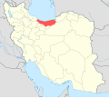
File:IranMazandaran-SVG.svg
From Wikimedia Commons, the free media repository
Jump to navigation
Jump to search

Size of this PNG preview of this SVG file: 672 × 600 pixels. Other resolutions: 269 × 240 pixels | 538 × 480 pixels | 861 × 768 pixels | 1,147 × 1,024 pixels | 2,295 × 2,048 pixels | 1,200 × 1,071 pixels.
Original file (SVG file, nominally 1,200 × 1,071 pixels, file size: 470 KB)
File information
Structured data
Captions
Captions
Add a one-line explanation of what this file represents
Summary
[edit]| DescriptionIranMazandaran-SVG.svg |
English: IranMazandaran |
| Date | |
| Source | Iran location map.svg |
| Author | Yamaha5 |
Licensing
[edit]This file is licensed under the Creative Commons Attribution-Share Alike 3.0 Unported license.
- You are free:
- to share – to copy, distribute and transmit the work
- to remix – to adapt the work
- Under the following conditions:
- attribution – You must give appropriate credit, provide a link to the license, and indicate if changes were made. You may do so in any reasonable manner, but not in any way that suggests the licensor endorses you or your use.
- share alike – If you remix, transform, or build upon the material, you must distribute your contributions under the same or compatible license as the original.
File history
Click on a date/time to view the file as it appeared at that time.
| Date/Time | Thumbnail | Dimensions | User | Comment | |
|---|---|---|---|---|---|
| current | 02:34, 17 April 2017 |  | 1,200 × 1,071 (470 KB) | Oganesson007 (talk | contribs) | Standard |
| 12:13, 23 June 2013 |  | 1,200 × 1,071 (302 KB) | BasilLeaf (talk | contribs) | بروزرسانی مرزها | |
| 11:09, 12 April 2013 |  | 1,200 × 1,071 (301 KB) | Yamaha5 (talk | contribs) | correcting the map | |
| 10:54, 12 April 2013 |  | 1,200 × 1,071 (301 KB) | Yamaha5 (talk | contribs) | User created page with UploadWizard |
You cannot overwrite this file.
File usage on Commons
The following page uses this file:
File usage on other wikis
The following other wikis use this file:
- Usage on ar.wikipedia.org
- محافظات إيران
- كلاردشت
- جويبار
- شالوس
- بهشهر
- قائم شهر
- مقاطعة عباس آباد (مازندران)
- عباس آباد (مازندران)
- كلار آباد (مازندران)
- سلمان شهر (مازندران)
- مقاطعة بابلسر (مازندران)
- مقاطعة بهشهر
- مقاطعة شالوس
- مقاطعة فريدونكنار (مازندران)
- مقاطعة غلوغاه (مازندران)
- مقاطعة جويبار (مازندران)
- مقاطعة محمود آباد (مازندران)
- مقاطعة مياندورود (مازندران)
- مقاطعة نكا (مازندران)
- مقاطعة نوشهر
- مقاطعة نور
- مقاطعة قائم شهر
- مقاطعة رامسر
- مقاطعة ساري
- مقاطعة تنكابن (مازندران)
- فالوجا
- فالويا يا أوليا
- فالويا يا سوفلا
- فاناجم
- نور (إيران)
- محمود أباد
- رويان (إيران)
- أمير كلا
- تشمستان
- فريدونكنار
- كوهي خيل
- رينه (إيران)
- رستمكلا
- زيرأب
- بهنمير
- بلده (إيران)
- دابودشت
- فريم (إيران)
- غلوغاه (مازندران)
- غلوغاه (بابل)
- غتاب
- غزنك
- ايزد شهر
- كله بست
- خليل شهر
View more global usage of this file.
Metadata
This file contains additional information such as Exif metadata which may have been added by the digital camera, scanner, or software program used to create or digitize it. If the file has been modified from its original state, some details such as the timestamp may not fully reflect those of the original file. The timestamp is only as accurate as the clock in the camera, and it may be completely wrong.
| Width | 1200px |
|---|---|
| Height | 1070.635px |