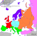
File:European political map (chopped).png
From Wikimedia Commons, the free media repository
Jump to navigation
Jump to search

Size of this preview: 616 × 600 pixels. Other resolutions: 247 × 240 pixels | 493 × 480 pixels | 942 × 917 pixels.
Original file (942 × 917 pixels, file size: 40 KB, MIME type: image/png)
File information
Structured data
Captions
Captions
Add a one-line explanation of what this file represents
Summary
[edit]| DescriptionEuropean political map (chopped).png |
English: see also Image:europe_political_map.png for broader version covering more of Africa, Asia, etc.
|
||||||||
| Date | Transferred from en.wikipedia to Commons by Shizhao. | ||||||||
| Source |
The original uploader was Alinor at English Wikipedia.; The original description page was political map (chopped).png here. All following user names refer to en.wikipedia. |
||||||||
| Author | Alinor at English Wikipedia | ||||||||
| Permission (Reusing this file) |
|
||||||||
| Other versions |
 |
File history
Click on a date/time to view the file as it appeared at that time.
| Date/Time | Thumbnail | Dimensions | User | Comment | |
|---|---|---|---|---|---|
| current | 16:49, 12 August 2022 |  | 942 × 917 (40 KB) | Рагин1987 (talk | contribs) | Correction |
| 16:31, 12 August 2022 |  | 942 × 917 (39 KB) | Рагин1987 (talk | contribs) | More correct visualization of the dividing line on the territory of the Caucasus Range | |
| 16:57, 15 February 2012 |  | 942 × 917 (64 KB) | Carnby (talk | contribs) | Better English captions | |
| 13:13, 25 May 2008 |  | 942 × 917 (153 KB) | Cecil (talk | contribs) | Reverted to version as of 11:10, 9 April 2008 is that a joke? waiting until the protection is over and than restarting the editwar? | |
| 09:39, 25 May 2008 |  | 942 × 917 (79 KB) | Olahus (talk | contribs) | ||
| 23:12, 20 May 2008 |  | 942 × 917 (153 KB) | MaCRoEco (talk | contribs) | Reverted to version as of 11:10, 9 April 2008 | |
| 20:56, 20 May 2008 |  | 942 × 917 (79 KB) | Olahus (talk | contribs) | ||
| 11:10, 9 April 2008 |  | 942 × 917 (153 KB) | Cecil (talk | contribs) | Reverted to version as of 20:14, 25 February 2008; situation before edit war | |
| 10:06, 9 April 2008 |  | 942 × 917 (79 KB) | Olahus (talk | contribs) | Reverted to version as of 10:40, 18 March 2008 | |
| 21:20, 8 April 2008 |  | 942 × 917 (153 KB) | MaCRoEco (talk | contribs) | Reverted to version as of 15:22, 15 March 2008 |
You cannot overwrite this file.
File usage on Commons
The following page uses this file:
File usage on other wikis
The following other wikis use this file:
- Usage on avk.wikipedia.org
- Usage on de.wikipedia.org
- Usage on eo.wikipedia.org
- Usage on eu.wikipedia.org
- Usage on frp.wikipedia.org
- Usage on fr.wikipedia.org
- Usage on ht.wikipedia.org
- Usage on it.wikipedia.org
- Usage on roa-tara.wikipedia.org
- Usage on tl.wikipedia.org
- Europa
- Bosniya at Herzegovina
- Malta
- San Marino
- Serbia
- Mga Italyano
- Golpo ng Pinlandiya
- Sofia
- Vaduz
- Lapland
- Kategorya:Stub (Espanya)
- Alpes
- Balkanikong Tangway
- Mga Madilim na Panahon
- Pook na Schengen
- Imperyo ng Niseya
- Silangang Alemanya
- Anna ng Britaniya
- Melusina
- Tom Jones
- Wikang Ukranyo
- Konde
- Yugoslavia
- Scandinavia
- Kategorya:Stub (Nagkakaisang Kaharian)
- Kategorya:Stub (Italya)
- Kategorya:Stub (Rusya)
- Kategorya:Stub (Alemanya)
- Kategorya:Stub (Pinlandiya)
- Kategorya:Stub (Awstriya)
View more global usage of this file.
Metadata
This file contains additional information such as Exif metadata which may have been added by the digital camera, scanner, or software program used to create or digitize it. If the file has been modified from its original state, some details such as the timestamp may not fully reflect those of the original file. The timestamp is only as accurate as the clock in the camera, and it may be completely wrong.
| Horizontal resolution | 28.32 dpc |
|---|---|
| Vertical resolution | 28.32 dpc |
