Category:Kerrera
Zur Navigation springen
Zur Suche springen
Insel in Schottland  | |||||
| Medium hochladen | |||||
| Ist ein(e) | |||||
|---|---|---|---|---|---|
| Ist Teil von | |||||
| Ort |
| ||||
| Liegt am oder im Gewässer | |||||
| Breite |
| ||||
| Länge |
| ||||
| Einwohnerzahl |
| ||||
| Fläche |
| ||||
 | |||||
Unterkategorien
Es werden 6 von insgesamt 6 Unterkategorien in dieser Kategorie angezeigt:
In Klammern die Anzahl der enthaltenen Kategorien (K), Seiten (S), Dateien (D)
B
- Balliemore, Kerrera (12 D)
G
- Gylen Castle (100 D)
H
- Hutcheson's Monument, Kerrera (27 D)
K
- Kerrera Lighthouse (22 D)
R
- RAF Oban (11 D)
Medien in der Kategorie „Kerrera“
Folgende 200 Dateien sind in dieser Kategorie, von 210 insgesamt.
(vorherige Seite) (nächste Seite)-
 'Downhill from here', Kerrera - geograph.org.uk - 5465527.jpg 1.024 × 768; 169 KB
-
 2004 - Two Trips to Oban (3999109597).jpg 1.704 × 2.272; 815 KB
-
 A 'Kerrera' stone - geograph.org.uk - 2407491.jpg 640 × 427; 220 KB
-
 A house on Kerrera near the ferry - geograph.org.uk - 2254619.jpg 1.024 × 768; 252 KB
-
 A Kerrera sheep and lamb on the edge - geograph.org.uk - 2399826.jpg 640 × 427; 192 KB
-
 A Milestone - geograph.org.uk - 5127934.jpg 640 × 427; 430 KB
-
 A rock formation on Kerrera - geograph.org.uk - 2413842.jpg 640 × 431; 240 KB
-
 A rock pinnacle on Kerrera - geograph.org.uk - 2413823.jpg 427 × 640; 192 KB
-
 A ruin on Kerrera - geograph.org.uk - 2420229.jpg 640 × 427; 231 KB
-
 A ruined cottage on Kerrera - geograph.org.uk - 2399835.jpg 640 × 427; 180 KB
-
 A seal on Sgeir Dhonn - geograph.org.uk - 5120781.jpg 1.280 × 1.280; 783 KB
-
 A small hawthorn tree on Kerrera - geograph.org.uk - 2399847.jpg 640 × 427; 185 KB
-

-
 A track on Kerrera - geograph.org.uk - 2420251.jpg 640 × 427; 182 KB
-
 A walking route on Kerrera - geograph.org.uk - 2413819.jpg 427 × 640; 204 KB
-
 A walking route on Kerrera - geograph.org.uk - 2413855.jpg 427 × 640; 202 KB
-
 A wild goat on Kerrera - geograph.org.uk - 2399890.jpg 640 × 468; 286 KB
-
 Admiralty Chart No 1790 Oban and Approaches, Published 1968.jpg 11.284 × 16.329; 31,64 MB
-
 Admiralty Chart No 2476 Frith of Lorn, Published 1856.jpg 8.269 × 14.016; 16,45 MB
-
 Admiralty Chart No 2476 Frith of Lorn, Published 1910.jpg 8.132 × 14.033; 12,28 MB
-
-
 Ardantrive Bay and Hills - geograph.org.uk - 3909734.jpg 640 × 427; 259 KB
-
 Ardantrive Bay, Kerrera (16517018929).jpg 2.048 × 971; 1.024 KB
-
 Ardantrive on Colonsay - geograph.org.uk - 3993786.jpg 3.264 × 2.448; 3,93 MB
-

-
 Argyll and Bute (21542992232).jpg 2.048 × 938; 1,09 MB
-
 Argyll and Bute (21940832122).jpg 1.600 × 1.600; 3,07 MB
-
 Argyll and Bute (22000928436).jpg 2.048 × 1.268; 2,14 MB
-
 Argyll and Bute (22007041351).jpg 1.600 × 1.066; 2,16 MB
-
 Argyll and Bute Kerrera.jpg 3.968 × 2.976; 6,39 MB
-
 Argyll and Bute Oban (16495217108).jpg 2.048 × 1.408; 1,95 MB
-
 Bar-nam-boc Bay, Kerrera - geograph.org.uk - 26665.jpg 640 × 480; 57 KB
-
 Barr nan Cadhag - geograph.org.uk - 5119878.jpg 1.280 × 720; 181 KB
-
 Barr-nam-boc Bay - geograph.org.uk - 5338137.jpg 1.600 × 1.067; 229 KB
-
 Barr-nam-boc, Insel Kerrera - panoramio.jpg 4.320 × 3.240; 5,41 MB
-
 Basalt columns, west coast of Kerrera - geograph.org.uk - 1754060.jpg 3.072 × 2.304; 1,78 MB
-
 Boat off Port an Fhearna, Kerrera - geograph.org.uk - 4085466.jpg 1.024 × 768; 129 KB
-
 Caledonian MacBrayne (2621129685).jpg 4.000 × 3.000; 2,59 MB
-
 Cliffs south of Cnoc na Faire - geograph.org.uk - 1756882.jpg 1.280 × 800; 257 KB
-
 Cnoc na Faire, Kerrera - geograph.org.uk - 4039551.jpg 3.264 × 2.448; 2,17 MB
-
 Coastal Argyll , Bins Across The Water - geograph.org.uk - 2984125.jpg 1.600 × 1.200; 204 KB
-
 Coastal Argyll , Port a' Chaisteil, Island of Kerrera - geograph.org.uk - 2983827.jpg 1.600 × 1.200; 273 KB
-
 Coastal Argyll , Taking Out The Bins (Kerrera Style) - geograph.org.uk - 2984094.jpg 1.600 × 1.200; 368 KB
-
 Coastal Argyll , The Balliemore Slipway, Isle of Kerrera - geograph.org.uk - 2983646.jpg 1.600 × 1.200; 302 KB
-

-
-
 Coastal Argyll , Up, Up and Away... - geograph.org.uk - 2984111.jpg 1.600 × 1.200; 385 KB
-

-
 Coastline at Rubh’a Cruidh - geograph.org.uk - 2024896.jpg 640 × 480; 38 KB
-
 Compost toilet near Lower Gylen - geograph.org.uk - 4165918.jpg 640 × 480; 449 KB
-
 Composting toilet, Kerrera - geograph.org.uk - 4910727.jpg 1.024 × 678; 159 KB
-

-
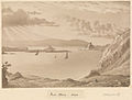 Edward Gennys Fanshawe, Near Oban, 1843 (Scotland).jpg 1.280 × 974; 1.015 KB
-
 Ellery Hill, Kerrera - geograph.org.uk - 3993826.jpg 3.264 × 2.448; 4,54 MB
-
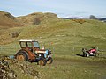 Farm vehicles old and new - geograph.org.uk - 140330.jpg 640 × 480; 83 KB
-
 Ferry House, Kerrera - geograph.org.uk - 3993872.jpg 3.264 × 2.448; 3,93 MB
-

-
 Ferry slip on Kerrera - geograph.org.uk - 2604581.jpg 2.640 × 1.980; 663 KB
-
 Ferry slipway on Kerrera - geograph.org.uk - 4166129.jpg 640 × 480; 536 KB
-
 Ferry to Kerrera (8758024626).jpg 4.086 × 1.362; 5,65 MB
-
 Gylen Castle Kerrera.jpg 2.048 × 1.103; 2,12 MB
-
 Gylen Castle View (16509960181).jpg 4.075 × 2.716; 2,87 MB
-
 Gylen castle, Kerrera - geograph.org.uk - 3293376.jpg 1.600 × 901; 503 KB
-
 Harbour at Ardantrive on Kerrera.JPG 1.632 × 1.224; 297 KB
-
 Heading For Oban - geograph.org.uk - 1377604.jpg 640 × 338; 48 KB
-
 Heather Island off Kerrera - geograph.org.uk - 5859930.jpg 1.653 × 1.000; 1,21 MB
-
 Heavy Shower Passing. (21375958808).jpg 2.048 × 1.228; 1,39 MB
-
 Hilltop Spire viewed from Oban - panoramio.jpg 4.320 × 3.240; 2,08 MB
-
 House on Rubh'a Chruidh - geograph.org.uk - 5052477.jpg 4.716 × 3.440; 4,3 MB
-
 Inside Gylen Castle.jpg 2.592 × 4.608; 4,03 MB
-

-
 Isle of Eigg, Calmac Ferry, at Oban (6056096485).jpg 1.280 × 695; 812 KB
-
 Isle of Kerrera (105399869).jpg 921 × 567; 67 KB
-
 Isle of Kerrera (105399928).jpg 913 × 596; 136 KB
-
 Isle of Kerrera from Oban Bay - geograph.org.uk - 3910557.jpg 640 × 427; 273 KB
-
 Isolated House at Oban - panoramio.jpg 4.320 × 3.240; 2,63 MB
-
 Kerrera - around Gylen castle 01.JPG 3.264 × 2.448; 1,47 MB
-
 Kerrera - around Gylen castle 02.JPG 3.264 × 2.448; 1,33 MB
-
 Kerrera - around Gylen castle 03.JPG 3.264 × 2.448; 1,38 MB
-
 Kerrera - around Gylen castle 04.JPG 3.264 × 2.448; 1,28 MB
-
 Kerrera - around Gylen castle 05.JPG 3.264 × 2.448; 1,21 MB
-
 Kerrera - around Gylen castle 06.JPG 3.264 × 2.448; 1,14 MB
-
 Kerrera - boat aground 02.JPG 3.264 × 2.448; 1,28 MB
-
 Kerrera - boat aground 03.JPG 3.264 × 2.448; 1,17 MB
-
 Kerrera - boat aground 04.JPG 2.448 × 3.264; 1,42 MB
-
 Kerrera - boat aground 05.JPG 3.264 × 2.448; 1,31 MB
-
 Kerrera - boat aground 06.JPG 3.264 × 2.448; 1,3 MB
-
 Kerrera - calves.JPG 3.264 × 2.448; 1,23 MB
-
 Kerrera - Dactylorhiza fuchsii 01.JPG 2.448 × 3.264; 1,3 MB
-
 Kerrera - Dactylorhiza fuchsii 02.JPG 3.264 × 2.448; 1,37 MB
-
 Kerrera - East coast 01.JPG 3.264 × 2.448; 1,34 MB
-
 Kerrera - East coast 02.JPG 3.264 × 2.448; 1,33 MB
-
 Kerrera - East coast 03.JPG 3.264 × 2.448; 4,41 MB
-
 Kerrera - East coast 04.JPG 3.264 × 2.448; 1,3 MB
-
 Kerrera - East coast 05.JPG 3.264 × 2.448; 1,44 MB
-
 Kerrera - from Gylen castle 01.JPG 3.264 × 2.448; 1,4 MB
-
 Kerrera - from Gylen castle 02.JPG 3.264 × 2.448; 1,37 MB
-
 Kerrera - from Gylen castle 03.JPG 3.264 × 2.448; 1,37 MB
-
 Kerrera - geograph.org.uk - 662081.jpg 640 × 480; 58 KB
-
 Kerrera - goat.JPG 2.766 × 1.938; 4,82 MB
-
 Kerrera - Hutchinson Monument 01.JPG 3.264 × 2.448; 4,86 MB
-
 Kerrera - Hutchinson Monument 02.JPG 3.167 × 2.375; 4,57 MB
-
 Kerrera - Hutchinson Monument 03.JPG 3.264 × 2.448; 1,32 MB
-
 Kerrera - path.jpg 3.264 × 2.448; 1,31 MB
-
 Kerrera - West coast 01.JPG 3.264 × 2.448; 1,27 MB
-
 Kerrera - West coast 02.JPG 3.264 × 2.448; 1,43 MB
-
 Kerrera - West coast 03.JPG 3.264 × 2.448; 1,34 MB
-
 Kerrera - West coast 04.JPG 3.264 × 2.448; 1,33 MB
-
 Kerrera - West coast 05.JPG 3.264 × 2.448; 1,28 MB
-
 Kerrera - West coast 06.JPG 3.264 × 2.448; 1,26 MB
-
 Kerrera - West coast 07.JPG 3.264 × 2.448; 1,37 MB
-
 Kerrera Coast View - geograph.org.uk - 3439830.jpg 640 × 399; 78 KB
-
 Kerrera Ferry - geograph.org.uk - 1724097.jpg 3.648 × 2.736; 4,14 MB
-
 Kerrera Ferry - geograph.org.uk - 4086455.jpg 800 × 480; 87 KB
-
 Kerrera ferry - geograph.org.uk - 4360420.jpg 900 × 675; 879 KB
-
 Kerrera Ferry - geograph.org.uk - 5463655.jpg 1.024 × 768; 216 KB
-
 Kerrera Ferry.jpg 5.200 × 3.480; 21,1 MB
-
 Kerrera from Oban.jpg 2.048 × 1.536; 2,42 MB
-
 Kerrera Marina - geograph.org.uk - 43014.jpg 640 × 480; 86 KB
-
 Kerrera off Oban, Argyllshire.svg 311 × 371; 4,27 MB
-
 Kerrera Outline Map.svg 652 × 600; 25 KB
-
 Kerrera Shore and Hutcheson's Monument - geograph.org.uk - 3909768.jpg 640 × 481; 244 KB
-
 Kerrera southern panorama.jpg 2.048 × 218; 539 KB
-
 Kerrera's post 'van' - geograph.org.uk - 4911593.jpg 1.024 × 678; 203 KB
-
 Kerrera, Ardantrive Bay - geograph.org.uk - 3910551.jpg 640 × 427; 259 KB
-
 Kerrera-houses.jpg 1.024 × 768; 298 KB
-
 Kerrera-isle.jpg 768 × 1.024; 469 KB
-
 Kerrera-sheep-overlooking.jpg 768 × 1.024; 391 KB
-
 Kerrera-sheep.jpg 768 × 1.024; 445 KB
-
 Kerrera.jpg 3.936 × 2.952; 4,1 MB
-
 Last House on Kerrera - geograph.org.uk - 3909745.jpg 640 × 481; 289 KB
-
 Little Horse Shoe Bay - geograph.org.uk - 5128065.jpg 640 × 430; 286 KB
-
 MacBrayne - Kerrera - Mull - geograph.org.uk - 5016825.jpg 4.320 × 3.240; 2,55 MB
-

-
 Monument on Kerrera - geograph.org.uk - 1854949.jpg 960 × 720; 106 KB
-
 Mount Pleasant on Kerrera - geograph.org.uk - 3993776.jpg 3.264 × 2.448; 2,53 MB
-
 Mull-26 (9041261371).jpg 4.862 × 3.438; 16 MB
-
 MV Carvoria.jpg 4.032 × 3.024; 3,37 MB
-
 MV Isle Of Mull (1021610444).jpg 1.600 × 1.200; 227 KB
-
 MV Isle of Mull (6898924758).jpg 1.280 × 792; 706 KB
-
 MV Isle of Mull - geograph.org.uk - 1728231.jpg 640 × 480; 97 KB
-
 MV Isle of Mull from Dunollie.JPG 2.592 × 1.944; 924 KB
-
 Navigation light on north eastern tip of Kerrera - geograph.org.uk - 5338437.jpg 1.600 × 1.091; 282 KB
-
 New house on Kerrera - geograph.org.uk - 2809254.jpg 1.250 × 1.228; 640 KB
-
 Nice Disconformity (16325410069).jpg 2.776 × 2.028; 2,64 MB
-
 North end of Kerrera - geograph.org.uk - 5438341.jpg 4.128 × 2.322; 1,76 MB
-
 Oban (6056104607).jpg 1.365 × 2.048; 2,99 MB
-
 Oban - boat leaving the haven 02.JPG 3.264 × 2.448; 1,21 MB
-
 Oban Ardantrive and the northeast of Kerrera Island seen from Corran Esplanade.jpg 5.904 × 3.808; 9,89 MB
-
 Oban Bay and Kerrera Island seen from George Street 1.jpg 6.000 × 4.000; 11,88 MB
-
 Oban Bay, from North Pier - geograph.org.uk - 807167.jpg 640 × 416; 49 KB
-
 Oban High part of Kerrera Island seen from Corran Esplanade.jpg 5.844 × 3.880; 11,9 MB
-
 Oban Kerrera Island seen from the roundabout at Corran Esplanade.jpg 6.000 × 4.000; 11,58 MB
-
 Oban Marina, Ardantrive Bay, Kerrera (10238243745).jpg 1.600 × 455; 593 KB
-
 Oitir Mhòr House - geograph.org.uk - 5120784.jpg 1.280 × 1.280; 450 KB
-
 Ordnance Survey One-inch Sheet 52 Loch Awe, Published 1956.jpg 8.604 × 10.703; 19,42 MB
-
 Ordnance Survey One-Inch Sheet 60 North Jura and Firth of Lorne, Published 1925.jpg 8.823 × 14.239; 11,94 MB
-
 Passenger ferry and slip on Kerrera - geograph.org.uk - 3993854.jpg 3.264 × 2.448; 2,76 MB
-
 Pasture, wood and moor on Kerrera - geograph.org.uk - 3994960.jpg 3.264 × 2.448; 4,01 MB
-
 Port a' Chaisteil - geograph.org.uk - 6213568.jpg 1.024 × 575; 150 KB
-
 Port a' Chaisteil and Gylen Castle, Kerrera - geograph.org.uk - 4682667.jpg 4.608 × 3.456; 4,39 MB
-
 Port a' Chaisteil below Gylen Castle, Kerrera - geograph.org.uk - 5465522.jpg 1.024 × 767; 311 KB
-
 Port a' Chroinn - geograph.org.uk - 4165908.jpg 640 × 480; 452 KB
-
 Port a' Chroinn - geograph.org.uk - 5083324.jpg 4.896 × 3.672; 6,7 MB
-
 Port a' Chroinn - geograph.org.uk - 6213562.jpg 1.024 × 575; 216 KB
-
 Port a'Chroinn, Kerrera - geograph.org.uk - 4682366.jpg 4.608 × 3.456; 4,34 MB
-
 Port Dubh - geograph.org.uk - 6213579.jpg 1.024 × 575; 141 KB
-
 Port nan Cuilc - geograph.org.uk - 2294752.jpg 1.500 × 784; 1,02 MB
-
 Rain over Kerrera and Oban Bay - geograph.org.uk - 2947846.jpg 3.264 × 2.448; 2,66 MB
-
 Rocky bay south-east of Ardmore - geograph.org.uk - 5465461.jpg 1.024 × 768; 198 KB
-
 Rubh'a' Bhearnaig, Kerrera - geograph.org.uk - 3909809.jpg 640 × 427; 236 KB
-
 Rubha a' Fhreastaig - geograph.org.uk - 1754088.jpg 2.880 × 2.160; 1,42 MB
-
 Rubha Seanach, Kerrera - geograph.org.uk - 4039545.jpg 3.264 × 2.448; 3,75 MB
-
 Seal Island - Sgeir Dhonn - geograph.org.uk - 7296.jpg 640 × 480; 94 KB
-
 Seal Island, Sgeir Dhonn - geograph.org.uk - 2496634.jpg 800 × 600; 61 KB
-
 Seaplane Terminal - geograph.org.uk - 1304716.jpg 640 × 427; 68 KB
-
 Sgeir Dhonn - geograph.org.uk - 5120779.jpg 1.280 × 720; 173 KB
-

-

-
 Slatrach Bay, Kerrera - geograph.org.uk - 3108821.jpg 3.264 × 2.448; 1,69 MB
-
 Sound of Kerrera (9883917295).jpg 2.048 × 683; 1,21 MB
-

-
 The Horse Shoe - geograph.org.uk - 184170.jpg 640 × 480; 116 KB
-
 The Horse Shoe - geograph.org.uk - 4166112.jpg 640 × 480; 470 KB
-
 The Horse Shoe on Kerrera - geograph.org.uk - 3994081.jpg 3.264 × 2.448; 4,14 MB
-
 The Horse Shoe, Kerrera - geograph.org.uk - 4086467.jpg 800 × 480; 74 KB
-
 The Kerrera ferry - geograph.org.uk - 3104802.jpg 3.264 × 2.448; 1,61 MB
-
 The Kerrera Ferry Jetty - geograph.org.uk - 3995252.jpg 1.600 × 1.200; 686 KB
-

-

-

-
 The Quarterly journal of the Geological Society of London (12734285014).jpg 1.945 × 3.200; 1,25 MB
-
 The Quarterly journal of the Geological Society of London (12734290764).jpg 3.200 × 1.945; 958 KB
-
 The southern point of Kerrera - geograph.org.uk - 5083312.jpg 4.896 × 3.672; 5,98 MB
-
 Tight Folds - geograph.org.uk - 5127973.jpg 640 × 480; 559 KB
-
 Tiny beach below Cnoc na Faire - geograph.org.uk - 1753824.jpg 2.880 × 2.160; 1,62 MB
-
 Towards Kerrera - geograph.org.uk - 4056978.jpg 1.600 × 1.063; 403 KB
-

-
 Upper Gylen From the North - geograph.org.uk - 195653.jpg 640 × 480; 83 KB
-
 View from Druim Mor - geograph.org.uk - 24494.jpg 640 × 460; 139 KB

.jpg)


.jpg)


.jpg)
.jpg)
.jpg)
.jpg)

.jpg)


.jpg)


_-_geograph.org.uk_-_2984094.jpg)


.jpg)
.jpg)


.jpg)


.jpg)


.jpg)
.jpg)
.jpg)


.jpg)

.jpg)
.jpg)


.jpg)

.jpg)


_-_geograph.org.uk_-_26655.jpg)

.jpg)
.jpg)


_,_Kerrera,_looking_south_-_geograph.org.uk_-_1746871.jpg)


.jpg)
.jpg)
.jpg)
.jpg)
_ferry_%22Isle_of_Eigg%22_(Eilean_Eige)_passes_the_Hutcheson_Monument_on_Kerrera._David_Hutcheson_and_his_brother_founded_a_company_in_1851,_which_started_steamship_routes_(10238502196).jpg)