대한민국 (大韓民國)은 한반도(韓半島) 남부에 자리잡고 있는 나라이다. 북한에서는 남조선(南朝鮮)이라고 부른다. 제2차 세계 대전 후의 미국에 의한 한반도 점령을 계기로 1948년 8월 15일에 수립되었다. 정치 지리학상으로는 조선민주주의인민공화국(북한), 중화인민공화국(中華人民共和國), 일본(日本), 중화민국(中華民國)과 함께 동아시아에 속한다. 국제 사회에서 조선민주주의인민공화국(朝鮮民主主義人民共和國, DPR of Korea)과의 국가 명칭 "Korea" 혼동을 피하기 위하여, 흔히 대한민국을 남한(南韓)이라 지칭해서 북한(北韓) 과 구분할 때가 많다.
The Republic of Korea (South Korea) is an East Asian state on the southern half of the Korean Peninsula. To the north, it is bordered by ► North Korea (Democratic People's Republic of Korea), with which it was united until 1945. To the west, across the Yellow Sea, lies ► China, and to the southeast, across the Korea Strait, lies ► Japan. Approximately one-half of South Korea's population lives in or near the capital and largest city, Seoul, the second largest metropolitan area in the world.
This section holds a short summary of the history of the area of present-day Korea, illustrated with maps, including historical maps of former countries and empires that included present-day Korea.
This section holds copies of original general maps more than 70 years old.
A 1531 map of Korea
A map of Korea from the late 1600s.
17th century map of Japan with Korea by Francois Caron
A map of Korea from the early 1700s.
A 1757 map of Korea.
A map of Korea from the late 1700s.
A map of Korea from the late 1700s.
A map of Korea from the 1790s.
Korea and Japan in 1815
An 1850 map of Korea.
An 1860 map of Korea.
An 1861 map of Korea.
A section of an 1878 map of Korea and Japan.
A section of an 1882 map of Korea and Japan.
Japan with Korea in 1900
Satellite maps
Satellite map
Satellite map
Satellite map
Notes and references
General remarks:
The WIKIMEDIA COMMONS Atlas of the World is an organized and commented collection of geographical, political and historical maps available at Wikimedia Commons. The main page is therefore the portal to maps and cartography on Wikimedia. That page contains links to entries by country, continent and by topic as well as general notes and references.
Every entry has an introduction section in English. If other languages are native and/or official in an entity, introductions in other languages are added in separate sections. The text of the introduction(s) is based on the content of the Wikipedia encyclopedia. For sources of the introduction see therefore the Wikipedia entries linked to. The same goes for the texts in the history sections.
Historical maps are included in the continent, country and dependency entries.
The status of various entities is disputed. See the content for the entities concerned.
The maps of former countries that are more or less continued by a present-day country or had a territory included in only one or two countries are included in the atlas of the present-day country. For example the Ottoman Empire can be found in the Atlas of Turkey.


 Busan
Busan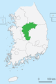 Chungcheong North
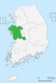 Chungcheong South
 Daegu
Daegu Gangwon
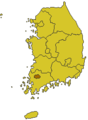 Gwangju
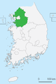 Gyeonggi
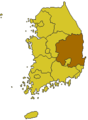 Gyeongsang North
 Gyeongsang South
 Incheon
 Jeju
Jeju Jeolla North
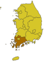 Jeolla South


.jpg)


