El Principat d'Andorra és un petit estat independent de l'Europa sud-occidental, la capital del qual és Andorra la Vella. És també un dels territoris dels Països Catalans. Durant molt de temps pobra i aïllada, la muntanyosa Andorra, situada als Pirineus entre Espanya al sud i França al nord, va començar a prosperar tímidament durant la Segona Guerra Mundial, aprofitant la postguerra civil espanyola per fer contraban de mercaderies i refugiar exiliats de tots els bàndols.
La Principauté d’Andorre ou l’Andorre - est un petit pays du Sud-Ouest de l’Europe situé dans les Pyrénées, entre l’Espagne (Catalogne) et la France (Midi-Pyrénées avec le département de l'Ariège et Languedoc-Roussillon avec celui des Pyrénées-Orientales).
El Principado de Andorra es un pequeño país independiente del sur-oeste de Europa, situado entre los Pirineos, entre España y Francia. Es también un de los países catalanes. Ha crecido mucho debido al turismo y los impuestos.
The Principality of Andorra is a small landlocked country in southwestern Europe, located in the eastern Pyrenees mountains and bordered by ► France and ► Spain. Once isolated, it is currently a prosperous country mainly because of tourism and its status as a tax haven.
This section holds a short summary of the history of the area of present-day Andorra, illustrated with maps, including historical maps of former countries and empires that included present-day Andorra.
The Principality of Andorra, disputed by Foix and la Seu d'Urgell, a survivor of one of the buffer states created by Charlemagne between his Frankish Empire and the islamic Moors, becomes as a compromise an independent feudal state in 1278, ruled by two co-princes, the count of Foix (later the head of state of France) and the bishop of Urgel. In 1419 Andorra gets a parliament, without real power. Only as late as in 1982 Andorra becomes more or less a constitional state.
Satellite maps
Satellite photo of Andorra covered in snow in winter
Satellite photo of Andorra in summer (the white patches are clouds)
Notes and references
General remarks:
The WIKIMEDIA COMMONS Atlas of the World is an organized and commented collection of geographical, political and historical maps available at Wikimedia Commons. The main page is therefore the portal to maps and cartography on Wikimedia. That page contains links to entries by country, continent and by topic as well as general notes and references.
Every entry has an introduction section in English. If other languages are native and/or official in an entity, introductions in other languages are added in separate sections. The text of the introduction(s) is based on the content of the Wikipedia encyclopedia. For sources of the introduction see therefore the Wikipedia entries linked to. The same goes for the texts in the history sections.
Historical maps are included in the continent, country and dependency entries.
The status of various entities is disputed. See the content for the entities concerned.
The maps of former countries that are more or less continued by a present-day country or had a territory included in only one or two countries are included in the atlas of the present-day country. For example the Ottoman Empire can be found in the Atlas of Turkey.


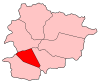 Andorra la Vella parish
 Canillo parish
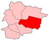 Encamp parish
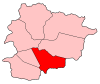 Escaldes-Engordany parish
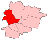 La Massana parish
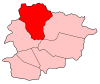 Ordino parish
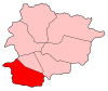 Sant Julià de Lòria parish


