Category:Spennymoor
town and civil parish in County Durham, England  | |||||
| Upload media | |||||
| Instance of | |||||
|---|---|---|---|---|---|
| Location | County Durham, North East England, England | ||||
| Population |
| ||||
| official website | |||||
 | |||||
Subcategories
This category has the following 10 subcategories, out of 10 total.
Media in category "Spennymoor"
The following 200 files are in this category, out of 245 total.
(previous page) (next page)-
 "The Frog and Ferret", Spennymoor - geograph.org.uk - 405553.jpg 640 × 480; 58 KB
-
 "The Winning Post" - geograph.org.uk - 405555.jpg 640 × 480; 61 KB
-
 A house by Stanner's Farm - geograph.org.uk - 3673816.jpg 1,368 × 1,824; 590 KB
-
 A167 Approaching Thinford - geograph.org.uk - 2480170.jpg 640 × 480; 253 KB
-
 A167 Towards Durham - geograph.org.uk - 2480163.jpg 640 × 480; 177 KB
-
 A167 towards Durham - geograph.org.uk - 4800933.jpg 640 × 480; 66 KB
-
 Arbour rear of Whitworth Hall Hotel - geograph.org.uk - 2088675.jpg 640 × 480; 127 KB
-
 Auckland Walk west of Spennymoor - geograph.org.uk - 3037861.jpg 1,500 × 843; 1.7 MB
-
 B6288 entering Croxdale - geograph.org.uk - 4818119.jpg 1,500 × 1,000; 1.4 MB
-
 B6288 heading north - geograph.org.uk - 4707935.jpg 1,500 × 1,125; 1.33 MB
-

-

-
 Barn, Todhills Farm - geograph.org.uk - 5891422.jpg 640 × 480; 56 KB
-
 Big foot - geograph.org.uk - 2589602.jpg 480 × 640; 72 KB
-
 Bishop's Close Farmhouse - geograph.org.uk - 1364525.jpg 640 × 480; 71 KB
-
 Black Plantation Spennymoor - geograph.org.uk - 2336361.jpg 640 × 480; 55 KB
-
 Bollards beside road climbing towards Kirk Merrington - geograph.org.uk - 4735700.jpg 1,500 × 1,125; 1.83 MB
-

-
 Bridleway heading towards Merrington Lane - geograph.org.uk - 4707918.jpg 1,500 × 1,125; 1.36 MB
-
 Bridleway near Burton Beck Farm - geograph.org.uk - 1018542.jpg 600 × 450; 115 KB
-
 Burton Woods at Whitworth Park - geograph.org.uk - 5069846.jpg 3,648 × 2,352; 4.88 MB
-
 Burton Woods at Whitworth Park - geograph.org.uk - 5069860.jpg 3,648 × 1,963; 4.38 MB
-
 Burton Woods housing estate, Spennymoor (2013) - geograph.org.uk - 3673841.jpg 1,549 × 1,177; 334 KB
-

-

-

-

-
 Bus stop on Vyners Close (B6288) - geograph.org.uk - 4812551.jpg 640 × 480; 63 KB
-
 Bus stop on Weardale Street (B6288) - geograph.org.uk - 4812561.jpg 640 × 480; 88 KB
-
 Bus stop opposite Dene Villas - geograph.org.uk - 4799667.jpg 640 × 480; 84 KB
-
 Byers Green Old Hall with arched door.jpg 4,320 × 3,240; 3.77 MB
-
 Byers Green Station - geograph.org.uk - 5835160.jpg 1,024 × 768; 395 KB
-
 Cheapside, Spennymoor - geograph.org.uk - 2589312.jpg 640 × 480; 130 KB
-
 Church Street towards Binchester - geograph.org.uk - 5891980.jpg 640 × 480; 91 KB
-

-
 Conference Suite in Spennymoor - geograph.org.uk - 1492109.jpg 640 × 480; 74 KB
-
 Crawleas Farm Leasingthorne County Durham - geograph.org.uk - 2025642.jpg 2,048 × 1,536; 674 KB
-
 Crop field near Todhills - geograph.org.uk - 5889013.jpg 640 × 480; 63 KB
-
 Crop field, North Close - geograph.org.uk - 4812550.jpg 640 × 480; 70 KB
-

-
 Cycle Shelter, Surgery, Spennymoor - geograph.org.uk - 2905604.jpg 515 × 543; 63 KB
-
 David Wilson Homes, Whitworth Park - geograph.org.uk - 3673866.jpg 1,793 × 1,144; 555 KB
-
 Deer Park Lodge, Stanners Lane, Spennymoor - geograph.org.uk - 2336334.jpg 1,030 × 725; 46 KB
-
 Disused commercial property - geograph.org.uk - 4818901.jpg 1,500 × 808; 1 MB
-
 Downstream River Wear - geograph.org.uk - 3673753.jpg 1,731 × 1,271; 732 KB
-
 Duck, Whitworth Hall Country Park - geograph.org.uk - 2088659.jpg 640 × 480; 129 KB
-
 Durhamgate - geograph.org.uk - 4800937.jpg 640 × 401; 57 KB
-
 Edge of wheat field below Merrington Road - geograph.org.uk - 5499948.jpg 1,500 × 1,125; 1.4 MB
-
 Edison Drive, Spennymoor - geograph.org.uk - 4812555.jpg 640 × 480; 50 KB
-

-
 Elizabeth II postbox on High Street, Byers Green - geograph.org.uk - 5892211.jpg 3,183 × 2,374; 1.07 MB
-
 Elizabeth II postbox on Wear View, Byers Green - geograph.org.uk - 5892217.jpg 1,486 × 2,996; 877 KB
-
 Entering Byers Green - geograph.org.uk - 5891965.jpg 640 × 480; 67 KB
-
 Entering Kirk Merrington - geograph.org.uk - 4812540.jpg 640 × 480; 76 KB
-
 Entering North Close - geograph.org.uk - 4812542.jpg 640 × 480; 83 KB
-
 Entrance to Parkside off Carr Lane in Spennymoor - geograph.org.uk - 3322340.jpg 3,083 × 2,351; 3.39 MB
-
 Entrance to Spennymoor Cemetery - geograph.org.uk - 2042732.jpg 2,048 × 1,536; 645 KB
-
 Entry to Burton Woods at Whitworth Park - geograph.org.uk - 3673833.jpg 1,824 × 1,368; 601 KB
-
 Entry to Tudhoe Mill Wood - geograph.org.uk - 4794411.jpg 1,200 × 1,600; 683 KB
-
 Erosion of River Wear - geograph.org.uk - 4794746.jpg 1,500 × 984; 1.06 MB
-
 Erosion on the River Wear - geograph.org.uk - 1574399.jpg 640 × 480; 125 KB
-
 Farm machinery beside farm road - geograph.org.uk - 4794728.jpg 1,500 × 874; 1.31 MB
-
 Farm track near Red Hall Farm - geograph.org.uk - 4800921.jpg 640 × 480; 81 KB
-
 Field access gate - geograph.org.uk - 3673736.jpg 1,753 × 1,303; 832 KB
-

-
 Field near Binchester - geograph.org.uk - 5891978.jpg 640 × 480; 49 KB
-
 Fields north of Binchester - geograph.org.uk - 3322787.jpg 1,500 × 915; 1.06 MB
-

-
 Five Lane Ends Cemetery - geograph.org.uk - 4818860.jpg 1,500 × 1,000; 1.85 MB
-
 Flooded farmland near Stanner's Farm - geograph.org.uk - 4813761.jpg 640 × 480; 53 KB
-
 Footbridge over Brancepeth Beck - geograph.org.uk - 2337686.jpg 640 × 480; 70 KB
-

-
 Footpath along field edge - geograph.org.uk - 4707976.jpg 1,500 × 1,125; 2.04 MB
-
 Footpath leading off Merrington Lane - geograph.org.uk - 2564088.jpg 3,648 × 2,736; 3.23 MB
-
 Footpath to Merrington Grange and beyond - geograph.org.uk - 2564098.jpg 3,648 × 2,736; 3.75 MB
-
 Forest life in Spring Wood - geograph.org.uk - 1581679.jpg 640 × 480; 123 KB
-
 Former water company pumping station. Now a residence - geograph.org.uk - 3322336.jpg 2,545 × 1,975; 1.6 MB
-
 Front Street (B6288), Tudhoe - geograph.org.uk - 2479621.jpg 640 × 480; 223 KB
-
 Fungi, Whitworth Hall Hotel - geograph.org.uk - 2087685.jpg 640 × 480; 125 KB
-
 Gated entry into field - geograph.org.uk - 4347483.jpg 1,500 × 1,125; 1.33 MB
-
 Gateway to Whitworth Hall Park - geograph.org.uk - 2336345.jpg 640 × 480; 41 KB
-
 Gilling Crescent, Spennymoor - geograph.org.uk - 2047951.jpg 640 × 480; 50 KB
-
 Gravestones with autumnal trees - geograph.org.uk - 4704465.jpg 1,500 × 996; 1.6 MB
-
 Gravestones with autumnal trees - geograph.org.uk - 4706963.jpg 1,500 × 996; 1.86 MB
-
 Grazing Kirk Merrington - geograph.org.uk - 4812541.jpg 640 × 480; 58 KB
-
 Green Lane Industrial Estate - geograph.org.uk - 409050.jpg 640 × 480; 71 KB
-
 Half Moon Lane, Spennymoor - geograph.org.uk - 409053.jpg 640 × 480; 70 KB
-
 High Street, Byers Green - geograph.org.uk - 5891969.jpg 640 × 480; 50 KB
-
 High Street, Spennymoor - geograph.org.uk - 2589603.jpg 640 × 480; 135 KB
-
 Houses on High Street, Byers Green - geograph.org.uk - 5892215.jpg 640 × 495; 55 KB
-
 Houses on North Close Road - geograph.org.uk - 4812546.jpg 640 × 480; 66 KB
-
 Houses on Wear View, Byers Green - geograph.org.uk - 5891966.jpg 640 × 480; 64 KB
-
 Houses on Wear View, Byers Green - geograph.org.uk - 5892218.jpg 3,648 × 2,736; 1.49 MB
-
 Housing development in Middlestone Moor - geograph.org.uk - 4706935.jpg 1,500 × 958; 1.02 MB
-
 John Willetts Fireplace and Stove Centre - geograph.org.uk - 3322383.jpg 3,648 × 2,736; 1.6 MB
-
 Jubilee Gardens, Spennymoor - geograph.org.uk - 404783.jpg 640 × 480; 75 KB
-
 King Street, Spennymoor - geograph.org.uk - 4813712.jpg 640 × 480; 63 KB
-
 Kirk Merrington Parish Church - geograph.org.uk - 5862574.jpg 683 × 1,024; 184 KB
-

-

-
 Leafy crop, multiple pylon lines beyond - geograph.org.uk - 6007883.jpg 1,500 × 788; 1.08 MB
-
 Leisure Centre. Spennymoor. - geograph.org.uk - 502920.jpg 640 × 480; 79 KB
-
 Long Lane near Todhills - geograph.org.uk - 5889014.jpg 640 × 480; 90 KB
-
 Looking across to Stanner's Farm - geograph.org.uk - 3091752.jpg 4,608 × 3,456; 5.52 MB
-
 Merrington Grange Farm - geograph.org.uk - 4798666.jpg 640 × 480; 67 KB
-
 Merrington Mill Farm - geograph.org.uk - 408658.jpg 640 × 480; 89 KB
-
 Merrington Road towards Kirk Merrington - geograph.org.uk - 3549291.jpg 2,432 × 1,824; 1.43 MB
-
 Merrington View, Spennymoor - geograph.org.uk - 2047943.jpg 640 × 480; 85 KB
-
 Middlestone Moor Working Mens Club Spennymoor - geograph.org.uk - 2043710.jpg 2,048 × 1,536; 643 KB
-
 Nanny Pop Lonnen - geograph.org.uk - 1364385.jpg 640 × 480; 89 KB
-
 North Close Road - geograph.org.uk - 4812547.jpg 640 × 480; 85 KB
-
 North Road, Tudhoe - geograph.org.uk - 2499255.jpg 608 × 456; 135 KB
-
 Old ford on the river Wear - geograph.org.uk - 245810.jpg 640 × 480; 95 KB
-
 Old Park Terrace - geograph.org.uk - 1373983.jpg 640 × 480; 71 KB
-
 Open space at 'DurhamGate' - geograph.org.uk - 4818889.jpg 1,499 × 779; 772 KB
-
 Ordnance Survey Cut Mark - geograph.org.uk - 5907139.jpg 1,024 × 644; 214 KB
-
 Parkwood Precinct, Spennymoor - geograph.org.uk - 2589609.jpg 640 × 480; 116 KB
-
 Parkwood Precinct, Spennymoor - geograph.org.uk - 2589611.jpg 640 × 480; 109 KB
-
 Path at west side of Spennymoor - geograph.org.uk - 3038193.jpg 1,500 × 931; 1.62 MB
-
 Path beside the A167 - geograph.org.uk - 4800918.jpg 640 × 480; 51 KB
-
 Path beside the A167 - geograph.org.uk - 4800928.jpg 640 × 480; 55 KB
-
 Pond near North Park Lodge Farm - geograph.org.uk - 4813730.jpg 640 × 480; 81 KB
-
 Pond, Windlestone Lane - geograph.org.uk - 404409.jpg 640 × 480; 69 KB
-
 Pony trotting, Spennymoor - geograph.org.uk - 404411.jpg 640 × 480; 84 KB
-
 Red Hall Farm - geograph.org.uk - 4800922.jpg 640 × 440; 48 KB
-
 Replica Boundary Marker - geograph.org.uk - 6541089.jpg 768 × 1,024; 319 KB
-
 River Wear - geograph.org.uk - 1018594.jpg 600 × 450; 122 KB
-
 River Wear - geograph.org.uk - 1018596.jpg 600 × 450; 89 KB
-
 River Wear at Page Bank - geograph.org.uk - 2054166.jpg 640 × 480; 125 KB
-
 River Wear near East Park - geograph.org.uk - 1737832.jpg 2,048 × 1,536; 2.11 MB
-
 River Wear west of Lowfield Farm - 2 - geograph.org.uk - 6753305.jpg 2,000 × 1,500; 2.71 MB
-
 River Wear west of Lowfield Farm - geograph.org.uk - 2770569.jpg 1,500 × 1,125; 1.65 MB
-
 Road off Cobey's Carr Lane - geograph.org.uk - 5889018.jpg 640 × 480; 92 KB
-
 Robert Duncombe Shafto.jpg 800 × 916; 151 KB
-

-
 Roundabout at Binchester Moor - geograph.org.uk - 6364276.jpg 3,078 × 1,011; 1.18 MB
-
 Santa on roundabout, Spennymoor - geograph.org.uk - 4813723.jpg 640 × 480; 56 KB
-

-
 Shafto's Bar and Restaurant, Spennymoor, County Durham.jpg 1,632 × 1,224; 305 KB
-
 Shingle bank in the River Wear - geograph.org.uk - 2336158.jpg 640 × 480; 39 KB
-
 Shops on Cheapside, Spennymoor - geograph.org.uk - 4812568.jpg 640 × 464; 68 KB
-
 Shops on Cheapside, Spennymoor - geograph.org.uk - 4813721.jpg 640 × 480; 64 KB
-

-

-
 Sign for The Weardale, Spennymoor - geograph.org.uk - 4787643.jpg 497 × 640; 64 KB
-
 Spennymoor entrance sign - geograph.org.uk - 2026261.jpg 640 × 480; 74 KB
-
 Spennymoor fire station - geograph.org.uk - 2022700.jpg 640 × 427; 209 KB
-
 Spennymoor fire station - geograph.org.uk - 288103.jpg 640 × 427; 149 KB
-
 Spennymoor Greyhound Stadium c.1980.png 858 × 627; 919 KB
-
 Spennymoor War Memorial - geograph.org.uk - 2589594.jpg 480 × 640; 60 KB
-
 Spennymoor, roadside gardens on route of old railway - geograph.org.uk - 3037917.jpg 1,500 × 843; 1.53 MB
-
 Spennymoor, sensory garden in Victoria Jubilee Park - geograph.org.uk - 3038000.jpg 1,500 × 843; 1.47 MB
-
 St Andrew's Church, Spennymoor - geograph.org.uk - 4812565.jpg 640 × 480; 62 KB
-
 St Paul's Gardens Spennymoor - geograph.org.uk - 2043658.jpg 2,048 × 1,536; 855 KB
-
 St. David's Church, Tudhoe - geograph.org.uk - 4818148.jpg 1,500 × 1,000; 1.42 MB
-
 Stanner's Lane - geograph.org.uk - 2634530.jpg 640 × 480; 135 KB
-
 Stanner's Lane - geograph.org.uk - 4813764.jpg 640 × 480; 51 KB
-
 Stone barn, Todhills Farm - geograph.org.uk - 5891423.jpg 640 × 480; 70 KB
-
 Sue's Florist, Windlestone Lane - geograph.org.uk - 404816.jpg 640 × 480; 71 KB
-
-
 The Bridge, High Street, Spennymoor - geograph.org.uk - 2589597.jpg 640 × 480; 122 KB
-
 The Bridge, Spennymoor - geograph.org.uk - 4787662.jpg 640 × 480; 56 KB
-
 The Fox Cub at Durham Gate - geograph.org.uk - 2859263.jpg 3,648 × 2,736; 2.12 MB
-
 The Fox Cub Public House - geograph.org.uk - 6364272.jpg 2,445 × 977; 1.92 MB
-
 The Frog ^ Ferret, Spennymoor - geograph.org.uk - 4787637.jpg 640 × 543; 62 KB
-
 The Grand Electric Hall, Spennymoor - geograph.org.uk - 4787648.jpg 640 × 480; 65 KB
-
 The North Eastern, Spennymoor - geograph.org.uk - 4787678.jpg 640 × 480; 64 KB
-
 The North Eastern, Spennymoor - geograph.org.uk - 4787680.jpg 640 × 458; 60 KB
-
 The Old Eden Arms a residence in Leasingthorne - geograph.org.uk - 2048876.jpg 2,048 × 1,536; 868 KB
-
 The Penny Gill, Cheapside, Spennymoor - geograph.org.uk - 2589295.jpg 640 × 480; 144 KB
-
 The Penny Gill, Spennymoor - geograph.org.uk - 4787651.jpg 640 × 480; 80 KB
-
 The promise of things to come - geograph.org.uk - 405551.jpg 480 × 640; 123 KB
-
 The Railway Tavern, Spennymoor - geograph.org.uk - 4787681.jpg 640 × 480; 61 KB
-
 The River Wear - geograph.org.uk - 4813766.jpg 640 × 480; 61 KB
-
 The Royal Oak Inn, Byers Green - geograph.org.uk - 5891970.jpg 640 × 474; 54 KB
-
 The Thinford Inn - geograph.org.uk - 4788435.jpg 640 × 480; 55 KB
-

-
 The Weardale, Cheapside, Spennymoor - geograph.org.uk - 2589284.jpg 480 × 640; 68 KB
-
 The Weardale, Spennymoor - geograph.org.uk - 4787644.jpg 640 × 480; 75 KB
-
 The Winning Post at Spennymoor - geograph.org.uk - 2432861.jpg 3,648 × 2,736; 2.93 MB
-

-
 The Winning Post, Spennymoor - geograph.org.uk - 2576625.jpg 640 × 480; 108 KB
-
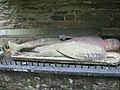 Tomb at Whitworth Parish Church - geograph.org.uk - 2088627.jpg 640 × 480; 86 KB
-
 Tomb at Whitworth Parish Church - geograph.org.uk - 2088639.jpg 640 × 480; 81 KB
-
 Town Centre. Spennymoor. - geograph.org.uk - 502925.jpg 640 × 480; 65 KB
-
 Traffic calming on Whitworth Road - geograph.org.uk - 4813729.jpg 640 × 480; 83 KB
-
 Traffic lights at urban road junction in Spennymoor - geograph.org.uk - 3673888.jpg 1,713 × 1,058; 455 KB
-
 Trees and water-run ground on south side of River Wear - geograph.org.uk - 4794743.jpg 1,500 × 1,125; 1.86 MB
-
 Trees in a crop field, North Close - geograph.org.uk - 4812548.jpg 640 × 480; 104 KB
-
 Upper Church Street, Spennymoor - geograph.org.uk - 404413.jpg 480 × 640; 74 KB
-
 Upstream River Wear - geograph.org.uk - 3673801.jpg 1,824 × 1,368; 797 KB
-
 View from Long Lane - geograph.org.uk - 4733014.jpg 640 × 584; 86 KB
-
 View from Whitworth Hall - geograph.org.uk - 2026280.jpg 640 × 480; 105 KB
-
 Vyners Close (B6288), Spennymoor - geograph.org.uk - 4812557.jpg 640 × 492; 64 KB
-
 War Memorial, Byers Green - geograph.org.uk - 5891973.jpg 640 × 480; 46 KB
-
 War Memorial, Spennymoor - geograph.org.uk - 4813719.jpg 640 × 480; 53 KB
-

-

-
 Wear View, Byers Green - geograph.org.uk - 4733004.jpg 640 × 480; 87 KB
-
 Wear View, Byers Green - geograph.org.uk - 5891967.jpg 640 × 480; 58 KB


_-_geograph.org.uk_-_3673841.jpg)

_-_geograph.org.uk_-_4812543.jpg)


_-_geograph.org.uk_-_4812551.jpg)
_-_geograph.org.uk_-_4812561.jpg)


,_Tudhoe_-_geograph.org.uk_-_2479621.jpg)


_-_geograph.org.uk_-_4812559.jpg)


,_Spennymoor_-_geograph.org.uk_-_4812557.jpg)


_rear_of_Whitworth_Hall_Hotel_-_geograph.org.uk_-_2088456.jpg)

