Ecosystem and Relict Cultural Landscape of Lopé-Okanda
Ecosystem and Relict Cultural Landscape of Lopé-Okanda
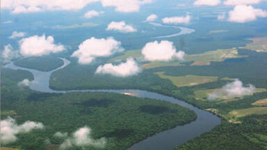
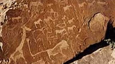
The Ecosystem and Relict Cultural Landscape of Lopé-Okanda demonstrates an unusual interface between dense and well-conserved tropical rainforest and relict savannah environments with a great diversity of species, including endangered large mammals, and habitats. The site illustrates ecological and biological processes in terms of species and habitat adaptation to post-glacial climatic changes. It contains evidence of the successive passages of different peoples who have left extensive and comparatively well-preserved remains of habitation around hilltops, caves and shelters, evidence of iron-working and a remarkable collection of some 1,800 petroglyphs (rock carvings). The property’s collection of Neolithic and Iron Age sites, together with the rock art found there, reflects a major migration route of Bantu and other peoples from West Africa along the River Ogooué valley to the north of the dense evergreen Congo forests and to central east and southern Africa, that has shaped the development of the whole of sub-Saharan Africa.
Description is available under license CC-BY-SA IGO 3.0
Ecosystème et paysage culturel relique de Lopé-Okanda
Le bien présente une interface inhabituelle entre une forêt tropicale ombrophile dense bien conservée et un milieu de savane relique abritant un large éventail d’habitats et d’espèces, parmi lesquelles de grands mammifères en voie de disparition. Il illustre des processus écologiques et biologiques d’adaptation des espèces et des habitats aux changements climatiques postglaciaires. Cet ensemble regroupant des sites datant du néolithique et de l’âge du fer et incluant des vestiges d’œuvres d’art rupestre est le reflet d’un axe migratoire majeur emprunté par les Bantous et par d’autres peuples originaires d’Afrique de l’Ouest qui longeaient la vallée de l’Ogooué pour se rendre vers le nord des forêts sempervirentes denses du Congo et vers le centre, l’est et le sud du continent africain. Ces flux migratoires ont façonné le développement de toute l’Afrique subsaharienne.
Description is available under license CC-BY-SA IGO 3.0
النظام البيئي والمناظر الطبيعية الثقافية في لوبي
يعرض هذا الموقع جانباً استثنائياً للغابات المدارية المطيرة المنتشرة بكثافة في المنطقة وبيئة المروج التي تتميز بتنوع غني، بما يشمل الثدييات الضخمة المهددة والمستوطنات الحيوانية والنباتية العديدة. يظهِر الموقع التكيف البيئي والبيولوجي مع التغيرات المناخية منذ نهاية العصر الجليدي. كما يحتوي على أدلة حول تعاقب الشعوب التي خلفت وراءها آثاراً سكنية في محيط التلال والهضاب والكهوف والملتجآت، وأدلة تشير إلى استخدام الأدوات الحديدية، ومجموعة لافتة من 800 1 نقش ونحت على الصخر. أدرج الموقع لأهمية مجموعته الأثرية التي ترقى إلى العصر الحجري الحديث وعصر الحديد، وآثار نقوشه الصخرية، وكلها تشير إلى طريق الهجرة الرئيسي لجماعة البانتو وشعوب أخرى من غرب أفريقيا على طول وادي نهر أوغويه شمالاً باتجاه غابات الكونغو الكثيفة والدائمة الخضرة ووسط وشرق وجنوب أفريقيا، مما أدى لاحقاً إلى تطور منطقة جنوب الصحراء الأفريقية.
source: UNESCO/CPE
Description is available under license CC-BY-SA IGO 3.0
洛佩──奥坎德生态系统与文化遗迹景观
洛佩──奥坎德生态系统与文化遗迹景观展示了保护完好的茂密热带雨林与残余热带草原环境之间的奇妙接合,这里的物种丰富,包括濒危的大型哺乳动物,是多种生物的栖息地。该遗址展现了生物及其栖息地适应冰川后期气候变化的生态和生物进程。这里有不同民族相继生活的证据,他们在山岭、岩洞和庇护所周围留下了大量保存比较完好的居住遗迹,同时还有炼铁的遗迹,遗迹约1800幅杰出的岩石雕刻。该遗产包括新石器时代和铁器时代遗址,还有岩刻艺术,共同反映了班图人(Bantu)和西非其他民族沿奥果韦河谷(the River Ogooué valley)向茂密的常绿刚果森林北部,再到中东部和南部非洲的主要移徙路线,这一移徙书写了撒哈拉以南非洲的发展。这是加蓬列入世界遗产的第一处遗址。
source: UNESCO/CPE
Description is available under license CC-BY-SA IGO 3.0
Экосистема и реликтовый культурный пейзаж Лопе-Оканда
Экосистема и реликтовый культурный пейзаж Лопе-Оканда представляет собой необычное сочетание густого и хорошо сохранившегося влажного тропического леса и реликтовой окружающей среды саванного типа, которое служит местом обитания большого разнообразия видов, включая исчезающих крупных млекопитающих. На примере этого объекта можно наглядно проследить экологические и биологические процессы адаптации видов и мест обитания к климатическим условиям, сложившимся после ледникового периода. Этот ансамбль, объединяющий поселения, датируемые неолитом и железным веком, и включающий остатки наскального искусства, отражает историю важного миграционного пути народа Банту и других народов Западной Африки, проходившего по долине реки Огове в направлении к северу от вечнозеленых лесов Конго и к центру, востоку и югу африканского континента. Эти миграционные потоки предопределили развитие всей Африки к югу от Сахары.
source: UNESCO/CPE
Description is available under license CC-BY-SA IGO 3.0
Ecosistema y Paisaje Cultural Arcaico de Lopé-Okanda
Este sitio es un ejemplo de una interfaz poco común entre un bosque lluvioso tropical, denso y bien conservado, y una sabana arcaica con gran variedad de hábitats y especies animales, entre las que figuran grandes mamíferos en peligro de extinción. También es un exponente de procesos de evolución, tanto ecológicos como biológicos, desde el punto de vista de la adaptación de las especies y los hábitats a los cambios climáticos postglaciares. El sitio presenta además huellas palpables de asentamientos humanos de la Era Neolítica y la Edad del Hierro, así como vestigios de arte rupestre, que demuestran la existencia de una importante ruta migratoria utilizada por los bantúes y otras poblaciones del África Occidental. Esa ruta, que ha contribuido a la configuración del África Subsahariana en su conjunto, partía del África Occidental y pasaba por el valle del río Ogooué para dirigirse luego hacia el norte de los bosques de hoja perenne del Congo y hacia el este y el sur del continente.
source: UNESCO/CPE
Description is available under license CC-BY-SA IGO 3.0
ロペ‐オカンダの生態系と残存する文化的景観
ガボン中央部のロペ-オカンダは、絶滅の危機に瀕する大型哺乳類などが生息するサバンナと、熱帯雨林といった異なる生態系をもつ。ここでは、特に最終氷期後の気候変動に適応してきた、生態学的及び生物学的な多様性を見ることができる。なかでも植物は、最近の20年間で発見された40以上の種を含め、1550種が確認されている。また、オゴウエ川沿いに位置するこの一帯は、先史時代からバントゥー人をはじめ多くの民族にとって、沿岸部と内陸を結ぶ交差路であり、移住地でもあった。丘の頂周辺や洞窟には、新石器時代及び鉄器時代に人類が暮らしていた痕跡や、約1800もの岩絵などが、良好な状態で残されている。source: NFUAJ
Ecosysteem en overgebleven cultuurlandschap van Lopé-Okanda
Het ecosysteem en overgebleven cultuurlandschap van Lopé-Okanda tonen een ongebruikelijk grensvlak tussen dicht en goed geconserveerd tropisch regenwoud en overgebleven savannegebieden. In deze gebieden uit de tijd van het neolithicum en de ijzertijd, zijn overblijfselen van bewoning gevonden en bewijs dat men met ijzer werkte. Er zijn ook 1.800 rotstekeningen aangetroffen. De overblijfselen en rotskunst laten zien dat er een belangrijke migratieroute was van Bantu en andere volken uit West Afrika naar het noorden van Congo en naar het centrale oosten en het zuidelijke Afrika. De route heeft de ontwikkeling van heel Afrika onder de Sahara bepaald.
Source: unesco.nl
Outstanding Universal Value
The Ecosystem and Relic Cultural Landscape of Lopé-Okanda represents an unusual interface between dense and well conserved tropical rainforest and relict savannah environments. A greater number of threatened species of large mammals find their last refuge in Lopé-Okanda than in any other comparable rainforest area in the Congo Rainforest Biogeographical Province. The property also preserves a record of biological evolution over the last 15,000 years of the still extant rainforest-savannah transition zone.
The Lopé-Okanda National Park displays remarkable evidence for settlement stretching over 400,000 years from the Palaeolithic, through the Neolithic and Iron Age, to the present day Bantu and Pygmy peoples. The National Park includes the River Ogooué valley, one of the principle migration routes for the diffusion of people and languages, including the Bantu, to Central and Southern Africa, in the Neolithic and Iron Age, as evidenced in extraordinary number of substantial settlements sites and an extensive collection of rock art petroglyphs.
The Lopé-Okanda National Park provides the oldest dates for the extension of the Tshitolien culture towards the Atlantic and it has revealed evidence of the early domestication of plants and animals and the use of forest resources.
Criterion (iii): the rich archaeological ensembles of the middle stretches of the River Ogooué Valley demonstrate 400,000 years of almost continuous history. The archaeological sites have revealed the earliest date for the extension of Tshitolien culture towards the Atlantic, as well as detailed evidence for the early use of forest produce, cultivation of crops and the domestication of animals.
Criterion (iv): the collection of Neolithic and Iron Age sites together with the rock art remains appear to reflect a major migration route of Bantu and other peoples along the River Ogooué valley to the north of the dense evergreen Congo forests from West Africa to central east and southern Africa, that has shaped the development of the whole of sub-Saharan Africa. The subsidiary Iron Age sites within the forest provide evidence for the development of forest communities and their relationship with present day peoples.
Criterion (ix): The nominated property demonstrates an unusual interface between forest and savannah environments, and a very important manifestation of evolutionary processes in terms of species and habitat adaptation to post-glacial climatic changes. The diversity of species and habitats present are the result of natural processes and also the long-term interaction between man and nature.
Criterion (x): The diversity of habitats and the complex relationship between forest and savannah ecosystems have contributed to a high biological diversity particularly in relation to the property's flora, making it one of the most outstanding areas in relation to floristic diversity and complexity in the Congo Rainforest Biogeographical Province. Over 1,550 plant species have been recorded, including 40 never recorded before in Gabon, and it is anticipated that once all the floristic surveys and research are completed the number of plant species could reach over 3,000.
The property is of sufficient size to maintain the long-term ecological viability of its habitats and ecosystems. The conservation and management of the property is guided by a management plan for the period 2006-2011 which is supported by international cooperation, particularly through a number of international and national NGOs. Conservation and management of the property also benefits from a number of transboundary cooperation initiatives. Key management issues include the need to resolve conflicts from competing interests, and to raise awareness amongst local people on the importance of conserving this property and to involve them in its management. Control and regulation of commercial poaching is of priority as well as the need to fully enforce regulations banning commercial logging within the property. Additional financial, logistical and human resources need to be obtained to ensure the effective management of the property and its buffer zone.
The authenticity of the archaeological sites and rock art site is intact. There is a need for consolidation of the excavated sites to be carried out to ensure that they are not eroded by natural or human processes.
The integrity of the cultural sites lies mainly in their relationship to one another along the River Ogooué Valley corridor which facilitated waves of migrations and subsidiary, later archaeological sites which fan out along the lesser river valleys within the forest. It would be desirable if at some point in the future that part of the river valley between the north-west corner of the National Park and the historic ensemble to the north-west could be included so that the integrity of the river corridor as a whole could be protected.
The legal protective measures for the property are adequate to protect the cultural attributes of the landscape. Without a mission to the main archaeological sites in the River Ogooué Valley, details of the state of conservation of the cultural property cannot be recorded. Currently there are no active conservation measures undertaken on the archaeological sites. Although many of the sites are remote and this remoteness will help provide good protection, it would appear that over time consolidation and remedial work will be needed. High priority should be given to putting in place one or more staff with appropriate training for archaeological sites and cultural landscapes.


