
Portal:Indiana
The Indiana Portal

Various indigenous peoples inhabited what would become Indiana for thousands of years, some of whom the U.S. government expelled between 1800 and 1836. Indiana received its name because the state was largely possessed by native tribes even after it was granted statehood. Since then, settlement patterns in Indiana have reflected regional cultural segmentation present in the Eastern United States; the state's northernmost tier was settled primarily by people from New England and New York, Central Indiana by migrants from the Mid-Atlantic states and adjacent Ohio, and Southern Indiana by settlers from the Upland South, particularly Kentucky and Tennessee.
Indiana has a diverse economy with a gross state product of $352.62 billion in 2021. It has several metropolitan areas with populations greater than 100,000 and a number of smaller cities and towns. Indiana is home to professional sports teams, including the NFL's Indianapolis Colts and the NBA's Indiana Pacers. The state also hosts several notable competitive events, such as the Indianapolis 500, held at Indianapolis Motor Speedway. (Full article...)
Selected article -

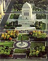
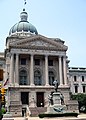
The Indiana Statehouse is the state capitol building of the U.S. state of Indiana. It houses the Indiana General Assembly, the office of the Governor of Indiana, the Indiana Supreme Court, and other state officials. The Statehouse is located in the capital city of Indianapolis at 200 West Washington Street. Built in 1888, it is the fifth building to house the state government.
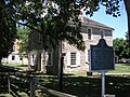
The first statehouse, located in Corydon, Indiana, is still standing and is maintained as a state historic site. The second building was the old Marion County courthouse which was demolished and replaced in the early 20th century. The third building was a structure modeled on the Parthenon, but was condemned in 1877 because of structural defects and razed so the current statehouse could be built on its location. (Full article...)Selected image -

Did you know -
- ... that the veto of an Indiana law that bans transgender girls from participating in school sports was overridden by the state legislature?
- ... that after becoming "convinced of the evils of slavery", James Townsend left Kentucky for Indiana?
- ... that Ganggang, an Indianapolis-based cultural development firm for Black artists, created a fine art fair called "Butter" that also included a dance party called "Melt"?
- ... that a woman hitchhiked from Indiana to Washington, D.C., to protest the sale of the radio station where she worked?
- ... that William N. Salin was twice decorated with the Sagamore of the Wabash?
- ... that the existence of Lego Indiana Jones 2: The Adventure Continues was accidentally leaked when it was displayed on an animator's résumé?
Related portals
Selected geographic article -

Lafayette (/ˌlɑːfiˈɛt, ˌlæf-/ LA(H)F-ee-ET) is a city in and is the county seat of Tippecanoe County, Indiana, United States, located 63 miles (101 km) northwest of Indianapolis and 125 miles (201 km) southeast of Chicago. According to the 2020 census, the population of Lafayette was 70,783. West Lafayette, on the other side of the Wabash River, is home to Purdue University, which contributes significantly to both communities. Together, they form the core of the Lafayette metropolitan area, which had a population of 235,066 in 2020, and the Greater Lafayette Region with a population of 303,631.
Lafayette was founded in 1825 on the southeast bank of the Wabash River near where the river becomes impassable for riverboats upstream, though a French fort and trading post had existed since 1717 on the opposite bank and three miles downstream. It was named for the French general Marquis de Lafayette, a Revolutionary War hero. (Full article...)Selected biography -

John Herbert Dillinger (/ˈdɪlɪndʒər/; June 22, 1903 – July 22, 1934) was an American gangster during the Great Depression. He commanded the Dillinger Gang, which was accused of robbing twenty-four banks and four police stations. Dillinger was imprisoned several times and escaped twice. He was charged with but not convicted of the murder of an East Chicago, Indiana, police officer, who shot Dillinger in his bullet-proof vest during a shootout; it was the only time Dillinger was charged with homicide.
Dillinger courted publicity. The media printed exaggerated accounts of his bravado and colorful personality, and described him as a Robin Hood-type figure. In response, J. Edgar Hoover, director of the Bureau of Investigation (BOI), used Dillinger as justification to evolve the BOI into the Federal Bureau of Investigation (FBI), developing more sophisticated investigative techniques as weapons against organized crime. (Full article...)Selected quote

General images
-
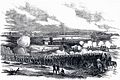 80th Indiana Infantry Regiment and the 19th Indiana Light Artillery defending against the Confederates at the Battle of Perryville by H. Mosler (from History of Indiana)
 -
 View of Mound A at Angel Mounds (from History of Indiana)
 -
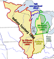 Map of the Indiana Territory (from History of Indiana)
 -
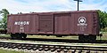 A restored Monon boxcar at the Linden Railroad Museum in Linden, Indiana (from History of Indiana)
 -
-
 The fifth Indiana Statehouse in Indianapolis built in 1888 on the site of the third statehouse (from History of Indiana)
 -
 The Circle in Indianapolis, circa 1898 (from History of Indiana)
 -
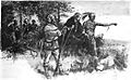 Native Americans guide French explorers through Indiana as depicted by Maurice Thompson in Stories of Indiana. (from History of Indiana)
 -
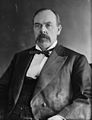 Oliver Hazard Perry Morton, governor 1861 to 1867 (from History of Indiana)
 -
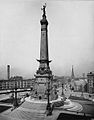
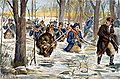 Clark's march to Vincennes, by F. C. Yohn (from History of Indiana)
 -
 William Henry Harrison, the 1st Governor of Indiana Territory from 1801 to 1812, and the 9th President of the United States (from History of Indiana)
 -
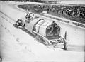 Driver Mel Marquette's wrecked McFarlan racing car at the 1912 Indianapolis 500 (from History of Indiana)
 -
-
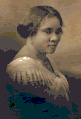 Madame C. J. Walker, Indianapolis entrepreneur and philanthropist (from History of Indiana)
 -
-
 The Constitution Elm in Corydon (from History of Indiana)


.jpg)

Topics

- Economy: AM General - ATA Airlines - Casinos - Cummins - Delta - ITT - JayC - Lilly - Limestone - Manufacturing - NiSource - Shoe Carnival - Simon Property Group - Soybeans - Studebaker - Vectren - WellPoint
- Geography: Caves - Lakes - Rivers - State forests - Watersheds
| Executive |  | |
|---|---|---|
| Legislature | ||
| Judiciary | ||
| Departments | ||
| Local government | ||
| Law | ||
Sports teams based in Indiana | |||||||||
|---|---|---|---|---|---|---|---|---|---|
| Baseball |  | ||||||||
| Basketball | |||||||||
| Football | |||||||||
| Hockey | |||||||||
| Motorsport | |||||||||
| Roller derby | |||||||||
| Soccer | |||||||||
| Ultimate | |||||||||
| Volleyball | |||||||||
| College athletics |
| ||||||||


Categories

Attractions


 |

Recognized content
| This is a list of recognized content, updated weekly by JL-Bot (talk · contribs) (typically on Saturdays). There is no need to edit the list yourself. If an article is missing from the list, make sure it is tagged (e.g. {{WikiProject Indiana}}) or categorized correctly and wait for the next update. See WP:RECOG for configuration options. |
Good articles
- 1963 Indiana State Fairgrounds Coliseum gas explosion
- 2006 Brickyard 400
- 2011 South Bend mayoral election
- 2015 South Bend mayoral election
- 2019 South Bend mayoral election
- 2021 NCAA Division I men's basketball championship game
- Max Bielfeldt
- The Fault in Our Stars (film)
- Hurley Goodall
- R. Ames Montgomery
- Proposed South Shore Line station in South Bend
- Richmond, Indiana, facility fire
- WCAE
Featured pictures
-
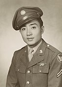 Kenje Ogata 1943
 -
 Kurt Vonnegut by Bernard Gotfryd (1965)
 -
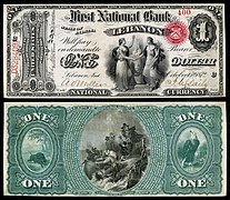 US-NBN-IL-Lebanon-2057-Orig-1-400-C

.jpg)

WikiProjects
State facts
Indiana | |
|---|---|
| Country | United States |
| Admitted to the Union | December 11, 1816 (19th) |
| Capital | Indianapolis |
| Largest city | Indianapolis |
| Largest metro and urban areas | Indianapolis-Carmel MSA |
| Government | |
| • Governor | Eric Holcomb (R) (2017) |
| • Lieutenant Governor | Suzanne Crouch (R) (2017) |
| Legislature | Indiana General Assembly |
| • Upper house | Senate |
| • Lower house | House of Representatives |
| U.S. senators | Todd Young (R) Mike Braun (R) |
| Population | |
| • Total | 6,080,485 |
| • Density | 169.5/sq mi (65.46/km2) |
| Language | |
| • Official language | English |
| Latitude | 37° 46′ N to 41° 46′ N |
| Longitude | 84° 47′ W to 88° 6′ W |
.JPG)


Things you can do
 |
Here are some tasks awaiting attention:
|
Associated Wikimedia
The following Wikimedia Foundation sister projects provide more on this subject:
-
 Commons
Free media repository -
 Wikibooks
Free textbooks and manuals -
 Wikidata
Free knowledge base -
 Wikinews
Free-content news -
 Wikiquote
Collection of quotations -
 Wikisource
Free-content library -
 Wikiversity
Free learning tools -
 Wikivoyage
Free travel guide -
 Wiktionary
Dictionary and thesaurus


- ^ a b "Elevations and Distances in the United States". U.S Geological Survey. 29 April 2005. Retrieved 2006-11-06.
{{cite web}}: CS1 maint: year (link)