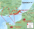
File:OperationSealion.svg
Appearance

Size of this PNG preview of this SVG file: 707 × 599 pixels. Other resolutions: 283 × 240 pixels | 566 × 480 pixels | 906 × 768 pixels | 1,208 × 1,024 pixels | 2,416 × 2,048 pixels | 5,277 × 4,473 pixels.
Original file (SVG file, nominally 5,277 × 4,473 pixels, file size: 2.04 MB)
File history
Click on a date/time to view the file as it appeared at that time.
| Date/Time | Thumbnail | Dimensions | User | Comment | |
|---|---|---|---|---|---|
| current | 19:06, 19 March 2013 |  | 5,277 × 4,473 (2.04 MB) | Hel-hama | text quality improved |
| 00:30, 2 April 2009 |  | 5,277 × 4,473 (1.66 MB) | Wereon | trying version without shadow relief | |
| 22:58, 1 April 2009 |  | 5,277 × 4,473 (3.46 MB) | Wereon | removed Inkscape cruft | |
| 19:20, 1 April 2009 |  | 5,277 × 4,473 (3.56 MB) | Wereon | . <!--{{ImageUpload|basic}}--> |
File usage
The following 6 pages use this file:
Global file usage
The following other wikis use this file:
- Usage on ar.wikipedia.org
- Usage on be.wikipedia.org
- Usage on br.wikipedia.org
- Usage on cs.wikipedia.org
- Usage on el.wikipedia.org
- Usage on en.wikibooks.org
- Usage on eu.wikipedia.org
- Usage on fa.wikipedia.org
- Usage on he.wikipedia.org
- Usage on id.wikipedia.org
- Usage on it.wikiquote.org
- Usage on ja.wikipedia.org
- Usage on ko.wikipedia.org
- Usage on no.wikipedia.org
- Usage on pl.wikipedia.org
- Usage on ro.wikipedia.org
- Usage on ru.wikipedia.org
- Usage on simple.wikipedia.org
- Usage on sk.wikipedia.org
- Usage on sv.wikipedia.org
- Usage on ta.wikipedia.org
- Usage on th.wikipedia.org
- Usage on tr.wikipedia.org
- Usage on uk.wikipedia.org
- Usage on vi.wikipedia.org
- Usage on www.wikidata.org
- Usage on zh.wikipedia.org


