
Spree Forest

The Spreewald (German for "Spree Woods"; in Lower Sorbian: Błota) is situated about 100 km south-east of Berlin. It was designated a biosphere reserve by UNESCO in 1991. It is known for its traditional irrigation system which consists of more than 200 small channels (called "Fließe"; total length: 1,300 km ) within the 484-square-kilometre (187 sq mi) area. The landscape was shaped during the ice-age. Alder forests on wetlands and pine forests on sandy dry areas are characteristic for the region. Grasslands and fields can be found as well.
Overview

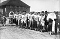
About 50,000 people live in the biosphere reserve (1998). Many of them are descendants of the first settlers in the Spreewald region, the Slavic tribes of the Sorbs/Wends. They have preserved their traditional language, customs and clothing to this day.
People mostly depend on tourism. Many tourists enjoy the exploration of the Spreewald in punts. Agriculture, forestry and fishery are other important sources of income. The principal town of the area is Lübbenau.
Spreewald gave its name to the following German districts:
Nature
About 18,000 species of flora and fauna have been counted. In 1991, the Spreewald was designated a UNESCO "Biosphärenreservat" (Man and Biosphere Reserve Programme).
Photogallery
-
 Wendish girls in Easter dresses, April 1930.
 -
 Traditional costume, c. 1948
 -
 "Greetings from Spreewald": a postcard from 1899
 -
 A tourist boat on a Spreewald canal in Lübbenau-Lehde
 -
 Typical flat bottomed river boat in Spreewald
 -
 Postal service at Lehde
 -
 Behind the alder tree is a haystack with the typical supporting post.


