
Glymur
| Glymur | |
|---|---|
 | |
 | |
 | |
| Location | West of Iceland |
| Coordinates | 64°23′45″N 21°14′28″W / 64.39583°N 21.24111°W |
| Type | Horsetail |
| Total height | 198 m (650 ft) |
| Number of drops | 1 |
Glymur (Icelandic pronunciation: [ˈklɪːmʏr̥]) is the second-highest waterfall in Iceland, with a cascade of 198 m. It was long regarded as the tallest until being surpassed by Morsárfoss, a newly measured waterfall near Morsárjökull in 2011.[1]
It is situated at the rear end of the Hvalfjörður. Since the opening of the Hvalfjörður Tunnel under this fjord, visitor numbers have dropped.[citation needed]
The river Botnsá runs from the Hvalvatn lake and after a short distance the water falls down alongside the Hvalfell mountain into a steep canyon. The waterfall can be accessed from a parking area at the end of the road. Hikers can view the waterfall from marked paths on the east side of the river Botnsá.
Gallery
-
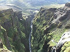 Downstream view of the canyon
 -
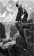 Legend of Rauðhöfði


Second picture is an engraving showing people trying to escape from a monster whale. It is an illustration to the Icelandic legend of Redhead (Rauðhöfði) which is said to be the cause of formation of Glymur.
See also
References
- ^ Guðmundsson, Janus Arn (2011-06-15). "Flyst hæsti foss landsins búferlum?" (in Icelandic). Morgunblaðið. Retrieved 1 August 2015.
External links
| International | |
|---|---|
| Geographic | |
This Iceland location article is a stub. You can help Wikipedia by expanding it. |