
Zhili: Difference between revisions
rev: please use my.wikipedia.org if you want to write in Burmese |
m →Gallery: Typo fixing, replaced: the its → its |
||
| Line 18: | Line 18: | ||
<gallery> |
<gallery> |
||
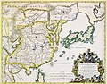
File:CEM-36-Regno-della-China-2355.jpg| A 1682 map of the "Kingdom of China, Presently Called [[Cathay]] and [[Manzi (geography)|Mangi]]", using the names "Peking" (Beijing) and "Nangking" (Nanjing) to refer to the Northern and Southern Zhilis |
File:CEM-36-Regno-della-China-2355.jpg| A 1682 map of the "Kingdom of China, Presently Called [[Cathay]] and [[Manzi (geography)|Mangi]]", using the names "Peking" (Beijing) and "Nangking" (Nanjing) to refer to the Northern and Southern Zhilis |
||
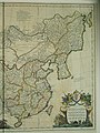
File:CEM-44-La-Chine-la-Tartarie-Chinoise-et-le-Thibet-1734-East-2570.jpg | The eastern half of [[Jean-Baptiste Bourguignon d'Anville|D'Anville]]'s 1734 map of China, Chinese Tartary, and Tibet, displaying "Pe-tche-li" (North Zhili) after |
File:CEM-44-La-Chine-la-Tartarie-Chinoise-et-le-Thibet-1734-East-2570.jpg | The eastern half of [[Jean-Baptiste Bourguignon d'Anville|D'Anville]]'s 1734 map of China, Chinese Tartary, and Tibet, displaying "Pe-tche-li" (North Zhili) after its southern counterpart became known as "Kiang-nan" (Jiangnan) |
||
File:Qing Dynasty 1820.png| The [[Qing Empire]] in 1820, with pinyin romanization |
File:Qing Dynasty 1820.png| The [[Qing Empire]] in 1820, with pinyin romanization |
||
File:1861 Johnson Map of China - Geographicus - China-johnson-1861.jpg|A map from 1861, which shows "Chihli" (Zhili). The former Jiangnan had already been divided between "Kiangsu" (Jiangsu) and "Nganhwui" (Anhui) |
File:1861 Johnson Map of China - Geographicus - China-johnson-1861.jpg|A map from 1861, which shows "Chihli" (Zhili). The former Jiangnan had already been divided between "Kiangsu" (Jiangsu) and "Nganhwui" (Anhui) |
||
Revision as of 17:54, 9 December 2019
| Zhili | |||||||||
|---|---|---|---|---|---|---|---|---|---|
 | |||||||||
| Traditional Chinese | 直隸 | ||||||||
| Simplified Chinese | 直隶 | ||||||||
| Literal meaning | Directly Ruled [Region] | ||||||||
| |||||||||
Zhili, alternately romanized as Chihli, was a northern province of China from the 14th-century Ming dynasty until the region was dissolved in 1911 and converted as a province (Zhili Province) and renamed as Hebei in 1928.
History
The name Zhili means "directly ruled" and indicates regions directly ruled by the imperial government of China. Zhili province was first constituted during the Ming dynasty when the capital of China was located at Nanjing along the Yangtze River. In 1403, the Ming Yongle Emperor relocated the capital to Beiping, which was subsequently renamed Beijing.[1] The region known as North Zhili was composed of parts of the modern provinces of Hebei, Henan, Shandong, including the provincial-level municipalities of Beijing and Tianjin. There was another region located around the "reserve capital" Nanjing known as South Zhili that included parts of what are today the provinces of Jiangsu and Anhui, including the provincial-level municipality of Shanghai.
During the Qing dynasty, Nanjing lost its status as the "second capital" and Southern Zhili was reconstituted as a regular province, Jiangnan, while Northern Zhili was renamed Zhili Province. In the 18th century the borders of Zhili province were redrawn and spread over what is today Beijing, Tianjin and the provinces of Hebei, Western Liaoning, Northern Henan, and the Inner Mongolia Autonomous Region.[citation needed]
After the collapse of Qing dynasty, in 1911, the National Government of the Republic of China converted Zhili into a province as Zhili Province. In 1928 the National Government assigned portions of northern Zhili province to its neighbors in the north and renamed the remainder Hebei Province.
Gallery
-
-
 The eastern half of D'Anville's 1734 map of China, Chinese Tartary, and Tibet, displaying "Pe-tche-li" (North Zhili) after its southern counterpart became known as "Kiang-nan" (Jiangnan)
 -
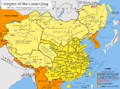 The Qing Empire in 1820, with pinyin romanization
 -
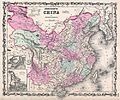 A map from 1861, which shows "Chihli" (Zhili). The former Jiangnan had already been divided between "Kiangsu" (Jiangsu) and "Nganhwui" (Anhui)


References
- ^ Susan Naquin, Peking: Temples and City Life, 1400-1900, p xxxiii
External links