
Bhandirban: Difference between revisions
Uploadsou14 (talk | contribs) Attribute to ASI, reposition of builder's name |
→Bhandeswar Shiv Mandir: clean up c/e |
||
| Line 72: | Line 72: | ||
==Bhandeswar Shiv Mandir== |
==Bhandeswar Shiv Mandir== |
||
| ⚫ | [[Bhandeswar]] [[Shiva|Shiv]] [[Hindu temple|Mandir]] is located behind the Gopal Mandir<ref name=":2" /><ref name="auto">{{Cite web|url=https://amitguha.blog/birbhum/|title=Birbhum|date=2017-12-18|website=Amit Guha|language=en|access-date=2019-01-24}}</ref>. Bhandeswar Shiva Temple was rebuilt by Ramnath Bhaduri. |
||
[[File:Bhandeswar Shiv-Mandir1.jpg|thumb|279x279px|Bhandeswar Shiv Mandir]] |
[[File:Bhandeswar Shiv-Mandir1.jpg|thumb|279x279px|Bhandeswar Shiv Mandir]] |
||
| ⚫ | [[Bhandeswar]] [[Shiva|Shiv]] [[Hindu temple|Mandir]] is located behind the Gopal Mandir<ref name=":2" /><ref name="auto">{{Cite web|url=https://amitguha.blog/birbhum/|title=Birbhum|date=2017-12-18|website=Amit Guha|language=en|access-date=2019-01-24}}</ref>. Bhandeswar Shiva Temple was rebuilt by Ramnath Bhaduri. The [[Archeological Survey of India]] have described the temple architecture in their report that stated<ref name=":2" /> " The style of architecture of the laterite stone temple built by Bhaduri is similar to the tall pyramida sikharal type, developed in the Radha country or south-west Bengal, the Ichai Ghosh Temple in Burdwan District and the Jatar Deul Temple in the Sundarbans being noteworthy examples, both prior in date to the present example by at least a century. The spire is about 45 feet high. The exterior surface of the temple is quite plain. The floor of the shrine is 5 feet lower than the level of platform, as is the case with many Saiva shrines. The enshrined linga is a natural boulder with the arghya built of stone masonry. To the right there is a stone image representing a four-handed goddess probably Durga, seated cross-legged, and holding a sword, trisula and lotus respectively in the lower right, lower left and upper left hands. At a short distance from the temple is a stone platform used in the dol festival of the neighbouring Gopala Temple" |
||
<br /> |
<br /> |
||
<gallery> |
<gallery> |
||
Revision as of 11:15, 31 January 2019
This article, Bhandirban, has recently been created via the Articles for creation process. Please check to see if the reviewer has accidentally left this template after accepting the draft and take appropriate action as necessary.
Reviewer tools: Inform author |
This article, Bhandirban, has recently been created via the Articles for creation process. Please check to see if the reviewer has accidentally left this template after accepting the draft and take appropriate action as necessary.
Reviewer tools: Inform author |
 Comment: no sources? Theroadislong (talk) 13:53, 23 January 2019 (UTC)
Bhandirban | |
|---|---|
Village | |
 Bhandirban Location in West Bengal, India  Bhandirban Bhandirban (India) Bhandirban Bhandirban (India) | |
| Coordinates: 23°58′22″N 87°27′41″E / 23.9728499°N 87.4614822°E | |
| Country | |
| State | West Bengal |
| District | Birbhum |
| Languages | |
| • Official | Bengali, English |
| Time zone | UTC+5:30 (IST) |
| Vehicle registration | WB |
| Lok Sabha constituency | Birbhum |
| Website | birbhum |
Bhandirban [1]village is a tourist destination[2]in Birbhum district of West Bengal state. The name of the place is also spelled alternatively as , Bhandier Bon [2] .Bhandirban village is administrated by the Khatanga, West Bengal gram panchayat of Suri I community development block in Suri Sadar subdivision of Birbhum district.[3][1] The village is located on the banks of the Mayurakshi River[4] on Suri-Dumka Highway at a distance of 10 km from the district headquarter at Suri , Birbhum..
History
This place was under Zemindari of Burdwan Maharaja [5] in British Era.There are two temple explored by Archeological Survey of India[5]- Bhandirban Gopal[6] Mandir and Bhandeswar Shiv Mandir situated in Bhandirban village.[5],.
Gopal Bari
Gopal Bari also known as Gopal Mandir is a temple dedicated to deity Krishna[6].[7]. Thestone plate on the temple credits the origin of the temple to the local legend, according to which a hermit Dhruv Goswami[8][9] while wandering at Bhandirban had placed on the ground, the twelve images of Gopal he was carrying. One of the images got stuck on the location where it was placed after which a temple was built at that location, by Ramnath Bhaduri[9][10] ,the Diwan of Murshidabad Nawab Muhhammad-Ul- Zaman Khan[10] in the year 1754[5]. Fairs and festivals on the eve of [[1]] [11]are celebrated every year there in the Bengali month of Kartik[9][10].
Bhandeswar Shiv Mandir

Bhandeswar Shiv Mandir is located behind the Gopal Mandir[5][12]. Bhandeswar Shiva Temple was rebuilt by Ramnath Bhaduri. The Archeological Survey of India have described the temple architecture in their report that stated[5] " The style of architecture of the laterite stone temple built by Bhaduri is similar to the tall pyramida sikharal type, developed in the Radha country or south-west Bengal, the Ichai Ghosh Temple in Burdwan District and the Jatar Deul Temple in the Sundarbans being noteworthy examples, both prior in date to the present example by at least a century. The spire is about 45 feet high. The exterior surface of the temple is quite plain. The floor of the shrine is 5 feet lower than the level of platform, as is the case with many Saiva shrines. The enshrined linga is a natural boulder with the arghya built of stone masonry. To the right there is a stone image representing a four-handed goddess probably Durga, seated cross-legged, and holding a sword, trisula and lotus respectively in the lower right, lower left and upper left hands. At a short distance from the temple is a stone platform used in the dol festival of the neighbouring Gopala Temple"
-
![Gopal Mandir]]](//upload.wikimedia.org/wikipedia/commons/thumb/b/ba/Sree_Gopal_Mandir.jpg/67px-Sree_Gopal_Mandir.jpg) Gopal Mandir]]
Gopal Mandir]] -

-
 outside Temple premises
 -
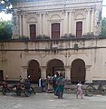 Mondir Gate
![Gopal Mandir]]](/https/en.wikipedia.org/wiki/File:Sree_Gopal_Mandir.jpg)


References
- ^ a b https://villageinfo.in/west-bengal/birbhum/suri-i/bhandirban.html. Retrieved 2019-01-24.
{{cite web}}: Cite has empty unknown parameter:|dead-url=(help); Missing or empty|title=(help) - ^ a b "Tourism-District Website of Birbhum". Archived from the original on 2018-04-29.
{{cite web}}: Unknown parameter|dead-url=ignored (|url-status=suggested) (help) - ^ "Barachaturi BPHC Community Health Center - Address and Reviews - Barachaturi Bphc, Khatanga, Near Khatanga Gram Panchayat Office, Khatanga, Block : Suri-i, Dist : Birbhum, Suri-I, Suri-i, Birbhum, West Bengal - Phone Number". tabletwise.
- ^ https://www.google.com/maps/place/Bhandirban,+West+Bengal+731126/@23.9743449,87.4620702,15z/data=!3m1!4b1!4m5!3m4!1s0x39f75725fce22835:0x82be93284ffc4d75!8m2!3d23.975997!4d87.4690648.
{{cite web}}: Cite has empty unknown parameter:|dead-url=(help); Missing or empty|title=(help) - ^ a b c d e f "Archeological Survey of India 1921-22 Page 77-78 by Dr .Brainerd Spooner" (PDF).
{{cite web}}: Cite has empty unknown parameter:|dead-url=(help) - ^ a b Ray, Biswanath (1993). West Bengal Today-A fresh Look. New Delhi-110059: Mittal. p. 335.
{{cite book}}: CS1 maint: location (link) - ^ "Gopalbari". Gopalbari. Retrieved 2019-01-24.
{{cite web}}: Cite has empty unknown parameter:|dead-url=(help) - ^ Chakraborty, Mahimaniranjan, Ed (1916). Birbhum Bibaran -Vol1. Printed by R.C Mittra, 9 Visvakosha Lane,Baghbazar, Calcutta: Digital Libraray of India Item 2015.515338. pp. 145–149.
{{cite book}}: CS1 maint: location (link) CS1 maint: multiple names: authors list (link) - ^ a b c Majumdar, Durgadas (1975). Full text of" Bengal District Gazetteers-Birbhum". 3 Rajendra Nath
Mukherjee Road, Calcutta* 1 and printed by Messrs N. K. Gossain 8e Co. (P) Ltd..
13/7. Ariff Road. Calcutta-Gy.: State Editor, West Bengal District Gazetteers. p. 558.
{{cite book}}: line feed character in|location=at position 17 (help)CS1 maint: location (link) - ^ a b c "Bengal District Gazetteers-- Birbhum , Page No-110 By L.S.S. O'Malley , Bengal Secretariat Book Depot 1910" (PDF). https://dspace.gipe.ac.in. 1920.
{{cite web}}:|first=missing|last=(help); Cite has empty unknown parameter:|dead-url=(help); External link in|website= - ^ Vemsani, Lavanya (2016). Krishna in History, Thought, and Culture: An Encyclopedia of the Hindu Lord ... 130, Cremona Drive, P.O.BOX-1911, Santa Barbara, California 93116-1911: Santa Barbara:ABC-CLIO. pp. Page 9, 10.
{{cite book}}: CS1 maint: location (link) - ^ "Birbhum". Amit Guha. 2017-12-18. Retrieved 2019-01-24.