
Bangalow: Difference between revisions
Bundjalung language word; change from Aboriginal |
add that is is on Bundjalung Land |
||
| Line 34: | Line 34: | ||
| location3= |
| location3= |
||
}} |
}} |
||
'''Bangalow''' is a small town in the [[Northern Rivers]] region of [[New South Wales]], Australia in [[Byron Shire]]. The town is {{convert|765|km}} north of [[Sydney]]<ref>[https://maps.google.com/maps?f=d&hl=en&geocode=&saddr=sydney,+australia&daddr=bangalow&sll=39.654769,-104.878839&sspn=0.011515,0.017724&ie=UTF8&t=h&z=7 Sydney-Bangalow] Google Maps</ref> and {{convert|167|km}} south of [[Brisbane]],<ref>[https://maps.google.com/maps?f=d&hl=en&geocode=&saddr=brisbane,+australia&daddr=bangalow&sll=-31.27487,152.335405&sspn=6.542562,9.074707&ie=UTF8&t=h&z=9 Brisbane-Bangalow] Google Maps</ref> just off the [[Pacific Highway, Australia|Pacific Highway]]. |
'''Bangalow''' is a small town in the [[Northern Rivers]] region of [[New South Wales]], Australia in [[Byron Shire]]. The town is {{convert|765|km}} north of [[Sydney]]<ref>[https://maps.google.com/maps?f=d&hl=en&geocode=&saddr=sydney,+australia&daddr=bangalow&sll=39.654769,-104.878839&sspn=0.011515,0.017724&ie=UTF8&t=h&z=7 Sydney-Bangalow] Google Maps</ref> and {{convert|167|km}} south of [[Brisbane]],<ref>[https://maps.google.com/maps?f=d&hl=en&geocode=&saddr=brisbane,+australia&daddr=bangalow&sll=-31.27487,152.335405&sspn=6.542562,9.074707&ie=UTF8&t=h&z=9 Brisbane-Bangalow] Google Maps</ref> just off the [[Pacific Highway, Australia|Pacific Highway]]. It is on the Lands of the [[Bundjalung people]].<ref>{{Cite web |title=Arakwal People of Byron Bay |url=https://arakwal.com.au/ |access-date=2024-07-15}}</ref> |
||
The town's name was derived from a [[Bundjalung language|Bundjalung]] word, "''Bangalla''", said to mean 'a low hill' or 'a kind of palm tree'.<ref>{{NSW GNR|id=MackFxrX|title=Bangalow|access-date=10 June 2009}}</ref><ref>{{Cite web |last= |date=2023-05-31 |title=Exploring the Charm and History of Bangalow, NSW, Australia |url=https://bangalowlocals.com.au/exploring-the-charm-and-history-of-bangalow-nsw-australia/ |access-date=2024-07-15 |website=Bangalow Locals |language=en-AU}}</ref> |
The town's name was derived from a [[Bundjalung language|Bundjalung]] word, "''Bangalla''", said to mean 'a low hill' or 'a kind of palm tree'.<ref>{{NSW GNR|id=MackFxrX|title=Bangalow|access-date=10 June 2009}}</ref><ref>{{Cite web |last= |date=2023-05-31 |title=Exploring the Charm and History of Bangalow, NSW, Australia |url=https://bangalowlocals.com.au/exploring-the-charm-and-history-of-bangalow-nsw-australia/ |access-date=2024-07-15 |website=Bangalow Locals |language=en-AU}}</ref> |
||
Revision as of 05:47, 15 July 2024
This article needs additional citations for verification. (June 2024) |
| Bangalow New South Wales | |
|---|---|
 Byron Street—Bangalow's main street | |
 Bangalow | |
| Coordinates | 28°42′0″S 153°31′0″E / 28.70000°S 153.51667°E |
| Population | 2,260 (2021 census)[1] |
| Postcode(s) | 2479 |
| Location | |
| LGA(s) | Byron Shire |
| State electorate(s) | Ballina |
| Federal division(s) | Richmond |
Bangalow is a small town in the Northern Rivers region of New South Wales, Australia in Byron Shire. The town is 765 kilometres (475 mi) north of Sydney[2] and 167 kilometres (104 mi) south of Brisbane,[3] just off the Pacific Highway. It is on the Lands of the Bundjalung people.[4]
The town's name was derived from a Bundjalung word, "Bangalla", said to mean 'a low hill' or 'a kind of palm tree'.[5][6]
History
Bangalow's historic streetscape, monthly market and proximity to the popular tourist resort of Byron Bay has increased its appeal as a tourist destination. Timber cutters established a camp on the banks of Byron Creek in the 1840s but it was not until the 1880s that a town appeared on the site. The town was known as Bangaloe until 1907, when the modern spelling came into use.[citation needed]
In recent years Bangalow has become a pleasant stop for holiday-makers and day-trippers as its main street is lined with modern cafes and boutique-shops. Organic produce grown nearby is a regular feature in the cafes, in particular the Byron Bay coffee-beans are a popular purchase.[citation needed]
Bangalow Public School was first built in 1884 and was originally known as the Byron Creek Provisional School and renamed in 1907.[7] In 1925, a 4 classroom brick building block was built which is now heritage listed.[8][9][10]
The Bangalow Uniting Church was first built in 1909 - 1910 but was destroyed and rebuilt in 1914 after a tornado blew down the original (Methodist) church. The church congregation is still active.[9][11]
Events
Bangalow is also home to the Bangalow Billy Cart Derby, which is held each year. It is a fun day, when the school has its fundraiser "The Mad Hatter's Teaparty".[citation needed]
Population
| Year | Pop. | ±% |
|---|---|---|
| 1966 | 479 | — |
| 1971 | 534 | +11.5% |
| 1976 | 568 | +6.4% |
| 1981 | 614 | +8.1% |
| 1986 | 677 | +10.3% |
| 1991 | 819 | +21.0% |
| 1996 | 896 | +9.4% |
| 2001 | 1,225 | +36.7% |
| 2006 | 1,327 | +8.3% |
| 2011 | 1,520 | +14.5% |
| 2016 | 1,689 | +11.1% |
| 2021 | 2,260 | +33.8% |
| Source: Australian Bureau of Statistics data.[12][13] | ||
At the 2021 census, Bangalow had a population of 2,260 people. 73.1% of people were born in Australia. The next most common countries of birth were England 7.1%, New Zealand 3.0% and United States of America 1.2%. 84.2% of people only spoke English at home. The most common responses for religion were No Religion 61.38%, Catholic 11.8%, Not stated 9.6% and Anglican 7.1%.[1]
Gallery
-
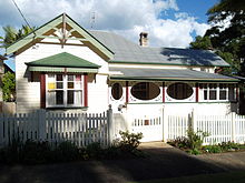 Private residence, Bangalow
 -
 Corner store
 -
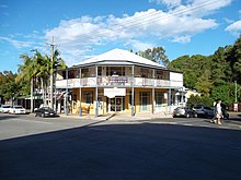
 Bangalow Hotel


.jpg)
References
- ^ a b Australian Bureau of Statistics (22 January 2024). [1]. 2021 Census QuickStats. 22 January 2024.
- ^ Sydney-Bangalow Google Maps
- ^ Brisbane-Bangalow Google Maps
- ^ "Arakwal People of Byron Bay". Retrieved 15 July 2024.
- ^ "Bangalow". Geographical Names Register (GNR) of NSW. Geographical Names Board of New South Wales. Retrieved 10 June 2009.
- ^ "Exploring the Charm and History of Bangalow, NSW, Australia". Bangalow Locals. 31 May 2023. Retrieved 15 July 2024.
- ^ Bangalow Public School (1 January 2021). "Welcome to Bangalow Public School: 2021 school information booklet" (PDF). Retrieved 15 July 2024.
- ^ "Bangalow Public School centenary, 1884-1984 - Catalogue | National Library of Australia". nla.gov.au. Retrieved 15 July 2024.
- ^ a b "History". Bangalow A & I Hall. Retrieved 15 July 2024.
- ^ "Byron local environmental plan 2014 - schedule 5". classic.austlii.edu.au. Retrieved 15 July 2024.
- ^ "Church History - Bangalow Uniting Church". bangalow.uca.org.au. Retrieved 15 July 2024.
- ^ "Statistics by Catalogue Number". Australian Bureau of Statistics. Retrieved 22 January 2024.
- ^ "Search Census data". Australian Bureau of Statistics. Retrieved 22 January 2024.
External links
- Byron Shire Council homepage
- Bangalow Chamber of Commerce and Visitor Information Archived 12 February 2002 at the Wayback Machine
- Bangalow information site
- Town information from the Sydney Morning Herald
- VISITNSW.com - Bangalow
This Northern Rivers geography article is a stub. You can help Wikipedia by expanding it. |