
Kappil, Thiruvananthapuram: Difference between revisions
No edit summary Tags: Mobile edit Mobile web edit |
Added contents Tags: Reverted Mobile edit Mobile web edit Disambiguation links added |
||
| Line 1: | Line 1: | ||
{{short description|Village in |
{{short description|Village in Kollam district,Kerala}} |
||
{{Use dmy dates|date=June 2018}} |
{{Use dmy dates|date=June 2018}} |
||
{{Use Indian English|date=June 2018}} |
{{Use Indian English|date=June 2018}} |
||
| Line 21: | Line 21: | ||
| subdivision_name1 = [[Kerala]] |
| subdivision_name1 = [[Kerala]] |
||
| subdivision_type2 = [[List of districts of India|District]] |
| subdivision_type2 = [[List of districts of India|District]] |
||
| subdivision_name2 = [[ |
| subdivision_name2 = [[Kollam]] |
||
| established_title = <!-- Established --> |
| established_title = <!-- Established --> |
||
| established_date = |
| established_date = |
||
| Line 46: | Line 46: | ||
| utc_offset1 = +5:30 |
| utc_offset1 = +5:30 |
||
| postal_code_type = [[Postal Index Number|PIN]] |
| postal_code_type = [[Postal Index Number|PIN]] |
||
| postal_code = 695311<ref>{{Cite web|url=http://www.mapsofindia.com/pincode/india/kerala/ |
| postal_code = 695311<ref>{{Cite web|url=http://www.mapsofindia.com/pincode/india/kerala/kollam/kappil.html|title=Pin Code of Kappil in Kollam, Kerala|access-date=2018-10-24|website=mapsofindia.com}}</ref> |
||
| area_code_type = Telephone code |
| area_code_type = Telephone code |
||
| Line 52: | Line 52: | ||
| registration_plate = KL 81 |
| registration_plate = KL 81 |
||
| blank1_name_sec1 = Nearest city |
| blank1_name_sec1 = Nearest city |
||
| blank1_info_sec1 = [[ |
| blank1_info_sec1 = [[Paravur]] |
||
| blank2_name_sec1 = [[Niyamasabha]] constituency |
| blank2_name_sec1 = [[Niyamasabha]] constituency |
||
| blank2_info_sec1 = [[ |
| blank2_info_sec1 = [[Paravur]] |
||
| website = |
| website = |
||
| footnotes = |
| footnotes = |
||
}} |
}} |
||
'''Kappil''' is a tourist place in [[ |
'''Kappil''' is a tourist place in [[Kollam district]] , Kerala state, India. It is located in [[Edava]] [[Panchayati Raj|Panchayat]] of [[Paravur Taluk]] at the coast of [[Arabian Sea]]. It is {{cvt|8|km}} north from Varkala city centre. [[Paravur Railway Station]] is major railway station near Kappil.<ref>{{Cite web|url=https://www.keralatourism.org/destination/kappil-beach-backwaters-Paravoor/427|title=Kappil beach and backwaters|access-date=2018-10-24|website=keralatourism.org|publisher=Kerala Tourism Department}}</ref> |
||
==Transportation== |
==Transportation== |
||
Revision as of 11:14, 5 February 2022
This article needs additional citations for verification. (May 2012) |
Kappil | |
|---|---|
Village | |
| Kappil - Varkala Coastal Road Kappil Road | |
 Kappil Location in Kerala, India  Kappil Kappil (India) | |
| Coordinates: 8°46′49″N 76°40′35″E / 8.78028°N 76.67639°E | |
| Country | |
| State | Kerala |
| District | Kollam |
| Government | |
| • Body | Edava Panchayat |
| Area | |
| • Total | 3 km2 (1 sq mi) |
| Languages | |
| • Official | Malayalam |
| Time zone | UTC+5:30 (IST) |
| PIN | 695311[1] |
| Telephone code | 0470 |
| Vehicle registration | KL 81 |
| Nearest city | Paravur |
| Niyamasabha constituency | Paravur |
Kappil is a tourist place in Kollam district , Kerala state, India. It is located in Edava Panchayat of Paravur Taluk at the coast of Arabian Sea. It is 8 km (5.0 mi) north from Varkala city centre. Paravur Railway Station is major railway station near Kappil.[2]
Transportation
- Road
Kappil is connected with Varkala - Paravur - Kollam Road. Varkala Municipal Bus Station opposite to Varkala Railway Station is well connected to Attingal, Trivandrum, Kollam, etc. KSRTC and private buses are doing services in Kappil village to adjacent cities like Varkala, Trivandrum, Kollam, Paravur, etc.
- Rail
Varkala Railway Station which is 7 km (4.3 mi) from Kappil is well connected to major cities like Trivandrum, Delhi, Chennai, Goa, Hyderabad, Kollam, Kochi, Mumbai, Kolkata, Kanyakumari, Bangalore etc.
Kappil railway station is within the village (700m) is connected by passenger trains from Trivandrum, Kollam, Nagercoil, Kanyakumari, Punalur etc.
Edavai railway station is within the panchayat, 4 km (2.5 mi) from Kappil is connected with passenger trains from Trivandrum, Kollam, Nagercoil etc.
- Air
Trivandrum International Airport which is 48 km from Kappil.
Tourism


Scenic backwaters, beach and facilities for watersport are available. Nellatil, Edava, Paravur, Nadayara, Varkala etc. are locations in the vicinity which are worth visiting.[opinion]
Kappil is also famous for Kappil Bhagavathy Temple and a tourist spot during the festival season.
Near by Places
- Varkala Beach
- Odayam Beach
- Manthra Beach
- Sivagiri Mutt
- Varkala Black Beach
- Janardhanaswami Temple
- Kappil Devi Temple,
Gallery
-
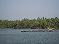
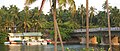 Kappil boatclub
 -
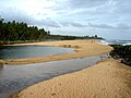 The lonely beach
 -
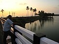 A beautiful evening view from Kappil bridge
 -
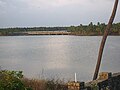 Edava-Nadayara Lake & Kappil Railway Bridge
 -
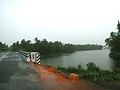 A rainy day
 -
 Thekkumbhagam boat race
 -
 Kappil beach


.jpg)

References
- ^ "Pin Code of Kappil in Kollam, Kerala". mapsofindia.com. Retrieved 24 October 2018.
- ^ "Kappil beach and backwaters". keralatourism.org. Kerala Tourism Department. Retrieved 24 October 2018.
External links
 Media related to Kappil at Wikimedia Commons
District HQ: Thiruvananthapuram | |||||||
| History |  | ||||||
| Geography | |||||||
| Cities and Taluks |
| ||||||
| Transport | |||||||
| Education |
| ||||||
| Buildings | |||||||
| Culture | |||||||
| Lok Sabha constituencies | |||||||
| Sports | |||||||
| Museums | |||||||
This article related to a location in Thiruvananthapuram district, Kerala, India is a stub. You can help Wikipedia by expanding it. |