
Glymur: Difference between revisions
No edit summary Tags: Mobile edit Mobile web edit Advanced mobile edit |
rearrange article, delete unrelated links, fix dead link |
||
| Line 11: | Line 11: | ||
| coords = {{coord|64|23|45|N|21|14|28|W}} |
| coords = {{coord|64|23|45|N|21|14|28|W}} |
||
}} |
}} |
||
| ⚫ | |||
[[File:Rauðhöfði.jpg|thumb|A portrait of the legend of the valley with the "Rauðhöfði", the evil whale]] |
|||
'''Glymur''' ({{IPA-is|ˈklɪːmʏr̥}}) is the second-highest [[waterfall]] in [[Iceland]], with a cascade of 198 m. It was long regarded as the tallest until being surpassed by [[Morsárfoss]], a newly measured waterfall near Morsárjökull in 2011.<ref>{{cite news|last1=Guðmundsson|first1=Janus Arn|title=Flyst hæsti foss landsins búferlum?|url=http://www.mbl.is/frettir/innlent/2011/06/15/flyst_haesti_foss_landsins_buferlum/|accessdate=1 August 2015|agency=Morgunblaðið|date=2011-06-15|language=Icelandic}}</ref> |
'''Glymur''' ({{IPA-is|ˈklɪːmʏr̥}}) is the second-highest [[waterfall]] in [[Iceland]], with a cascade of 198 m. It was long regarded as the tallest until being surpassed by [[Morsárfoss]], a newly measured waterfall near Morsárjökull in 2011.<ref>{{cite news|last1=Guðmundsson|first1=Janus Arn|title=Flyst hæsti foss landsins búferlum?|url=http://www.mbl.is/frettir/innlent/2011/06/15/flyst_haesti_foss_landsins_buferlum/|accessdate=1 August 2015|agency=Morgunblaðið|date=2011-06-15|language=Icelandic}}</ref> |
||
| Line 18: | Line 17: | ||
The river Botnsá runs from the [[Hvalvatn]] lake and after a short distance the water falls down alongside the Hvalfell mountain into a steep canyon. The waterfall can be accessed from a parking area at the end of the road. Hikers can view the waterfall from marked paths on the east side of the river Botnsá. |
The river Botnsá runs from the [[Hvalvatn]] lake and after a short distance the water falls down alongside the Hvalfell mountain into a steep canyon. The waterfall can be accessed from a parking area at the end of the road. Hikers can view the waterfall from marked paths on the east side of the river Botnsá. |
||
== Gallery == |
|||
<gallery mode='packed'> |
|||
| ⚫ | |||
Rauðhöfði.jpg|Legend of Rauðhöfði |
|||
</gallery> |
|||
Second picture is an engraving showing people trying to escape from a monster whale. It is an illustration to the Icelandic legend of Redhead (Rauðhöfði) which is said to be the cause of formation of Glymur. |
|||
==See also== |
==See also== |
||
| Line 27: | Line 33: | ||
==External links== |
==External links== |
||
{{Commons |
{{Commons}} |
||
*[ |
*[https://web.archive.org/web/20191202121200/https://www.nat.is/travelguideeng/plofin_glymur_waterfall.htm Information] |
||
*[http://eik.klaki.net/haf/02sept14/20020914_141120.jpg Photo] |
|||
*[http://site.voila.fr/gonguferdir/glymur.html Photos] |
|||
{{Waterfalls of Iceland}} |
{{Waterfalls of Iceland}} |
||
Revision as of 19:05, 30 March 2021
| Glymur | |
|---|---|
 | |
 | |
 | |
| Location | West of Iceland |
| Coordinates | 64°23′45″N 21°14′28″W / 64.39583°N 21.24111°W |
| Type | Horsetail |
| Total height | 198 m (650 ft) |
| Number of drops | 1 |
Glymur (Icelandic pronunciation: [ˈklɪːmʏr̥]) is the second-highest waterfall in Iceland, with a cascade of 198 m. It was long regarded as the tallest until being surpassed by Morsárfoss, a newly measured waterfall near Morsárjökull in 2011.[1]
It is situated at the rear end of the Hvalfjörður. Since the opening of the Hvalfjörður Tunnel under this fjord, visitor numbers have dropped.[citation needed]
The river Botnsá runs from the Hvalvatn lake and after a short distance the water falls down alongside the Hvalfell mountain into a steep canyon. The waterfall can be accessed from a parking area at the end of the road. Hikers can view the waterfall from marked paths on the east side of the river Botnsá.
Gallery
-
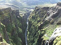 Downstream view of the canyon
 -
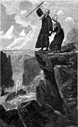 Legend of Rauðhöfði


Second picture is an engraving showing people trying to escape from a monster whale. It is an illustration to the Icelandic legend of Redhead (Rauðhöfði) which is said to be the cause of formation of Glymur.
See also
References
- ^ Guðmundsson, Janus Arn (2011-06-15). "Flyst hæsti foss landsins búferlum?" (in Icelandic). Morgunblaðið. Retrieved 1 August 2015.
External links
This Iceland location article is a stub. You can help Wikipedia by expanding it. |