
Griesheim, Hesse: Difference between revisions
Rescuing 1 sources and tagging 0 as dead.) #IABot (v2.0.9.5 |
m Bot: link syntax and minor changes |
||
| Line 23: | Line 23: | ||
|party = CDU |
|party = CDU |
||
}} |
}} |
||
'''Griesheim''' ({{IPA-de|ˈɡʁiːsˌhaɪ̯m|-|De-Griesheim.ogg}}) is the largest town in the [[Darmstadt-Dieburg]] district in [[Hesse]], [[Germany]], with just over 28,000 inhabitants as of December 2023.<ref>{{Cite web |title=Bevölkerung in Hessen |url=https://statistik.hessen.de/unsere-zahlen/bevoelkerung |access-date=2024-06-13 |website=statistik.hessen.de |language=de}}</ref> It is located within the |
'''Griesheim''' ({{IPA-de|ˈɡʁiːsˌhaɪ̯m|-|De-Griesheim.ogg}}) is the largest town in the [[Darmstadt-Dieburg]] district in [[Hesse]], [[Germany]], with just over 28,000 inhabitants as of December 2023.<ref>{{Cite web |title=Bevölkerung in Hessen |url=https://statistik.hessen.de/unsere-zahlen/bevoelkerung |access-date=2024-06-13 |website=statistik.hessen.de |language=de}}</ref> It is located within the ''[[regierungsbezirk]]'' ({{Literal translation|governmental district|administrative district|i=yes}}) of [[Darmstadt (region)|Darmstadt]]. |
||
News of the [[Dagger Complex]], which emerged as the most important of the [[National Security Agency|NSA]]'s headquarters in Europe in the wake of the [[Global surveillance disclosures (2013–present)|global surveillance disclosures]], brought Griesheim to public attention in 2013. |
News of the [[Dagger Complex]], which emerged as the most important of the [[National Security Agency|NSA]]'s headquarters in Europe in the wake of the [[Global surveillance disclosures (2013–present)|global surveillance disclosures]], brought Griesheim to public attention in 2013. |
||
| Line 38: | Line 38: | ||
From 1918 to 1930, Griesheim was under French occupation, and during [[World War II]], the city suffered significant damage, with 65% of its buildings destroyed. After the war, Griesheim provided shelter for approximately 4,000 refugees. Following successful reconstruction, the Hessian state government granted Griesheim township rights on September 12, 1965. |
From 1918 to 1930, Griesheim was under French occupation, and during [[World War II]], the city suffered significant damage, with 65% of its buildings destroyed. After the war, Griesheim provided shelter for approximately 4,000 refugees. Following successful reconstruction, the Hessian state government granted Griesheim township rights on September 12, 1965. |
||
Farming remains an important aspect of Griesheim's economy. The city is home to a local history and culture museum, showcasing archaeological artifacts and documenting its historical connection to St. Stephen. The museum also houses archaeological exhibits.<ref>[http://www.museum-griesheim.de/Startseite.10.0.html |
Farming remains an important aspect of Griesheim's economy. The city is home to a local history and culture museum, showcasing archaeological artifacts and documenting its historical connection to St. Stephen. The museum also houses archaeological exhibits.<ref>[http://www.museum-griesheim.de/Startseite.10.0.html Griesheim city museum]</ref> |
||
Since 1977, the ''Griesheimer Zwiebelmarkt'' (Onion Market) is held annually in late September,<ref>{{cite web | url=https://www.griesheim.de/freizeit-sport/feste-und-maerkte/zwiebelmarkt/ | title=Zwiebelmarkt: Griesheim }}</ref> which attracts visitors to the city center between Wagenhalle and Hans-Karl-Platz. |
Since 1977, the ''Griesheimer Zwiebelmarkt'' (Onion Market) is held annually in late September,<ref>{{cite web | url=https://www.griesheim.de/freizeit-sport/feste-und-maerkte/zwiebelmarkt/ | title=Zwiebelmarkt: Griesheim }}</ref> which attracts visitors to the city center between Wagenhalle and Hans-Karl-Platz. |
||
| Line 62: | Line 62: | ||
=== Roads === |
=== Roads === |
||
The main road passing west-east is the [[Bundesstraße 26]], or B26. |
The main road passing west-east is the [[Bundesstraße 26]], or B26. |
||
Griesheim |
Griesheim is situated just west of the [[Bundesautobahn 5]] and [[Bundesautobahn 67]] west of the [[Autobahn]]-interchange Darmstädter Kreuz. |
||
==Twin towns – sister cities== |
==Twin towns – sister cities== |
||
Revision as of 23:07, 18 August 2024
This article may be a rough translation from German. It may have been generated, in whole or in part, by a computer or by a translator without dual proficiency. (December 2021) |
Griesheim | |
|---|---|
_107.jpg) Aerial view | |
.svg) Coat of arms | |
Location of Griesheim within Darmstadt-Dieburg district  | |
 Griesheim  Griesheim | |
| Coordinates: 49°51′50″N 8°33′50″E / 49.86389°N 8.56389°E | |
| Country | Germany |
| State | Hesse |
| Admin. region | Darmstadt |
| District | Darmstadt-Dieburg |
| Government | |
| • Mayor (2022–28) | Geza Krebs-Wetzl[1] (CDU) |
| Area | |
| • Total | 21.4083 km2 (8.2658 sq mi) |
| Elevation | 96 m (315 ft) |
| Population (2022-12-31)[2] | |
| • Total | 27,837 |
| • Density | 1,300/km2 (3,400/sq mi) |
| Time zone | UTC+01:00 (CET) |
| • Summer (DST) | UTC+02:00 (CEST) |
| Postal codes | 64347 |
| Dialling codes | 06155 |
| Vehicle registration | DA |
| Website | www.griesheim.de |
Griesheim (German pronunciation: [ˈɡʁiːsˌhaɪ̯m] ) is the largest town in the Darmstadt-Dieburg district in Hesse, Germany, with just over 28,000 inhabitants as of December 2023.[3] It is located within the regierungsbezirk (lit. 'governmental district' or 'administrative district') of Darmstadt.
News of the Dagger Complex, which emerged as the most important of the NSA's headquarters in Europe in the wake of the global surveillance disclosures, brought Griesheim to public attention in 2013.
History
Griesheim, although inhabited since around 4500 BCE, first appeared in historical records only in 1165 CE. Throughout its history, wine production played a significant role in the town's economy. The arrival of the Protestant Reformation in 1529 marked an important religious turning point for the town.
The devastating impact of the Thirty Year War heavily affected Griesheim, almost bringing the town to extinction. Many residents sought refuge within the walls of Darmstadt, where they faced the outbreak of plague. Only 37 individuals managed to rebuild the community following the war's end in 1648.
During the late 18th and early 19th centuries, Griesheim thrived as a center for the production and trade of fir tree seeds, contributing to its local industry. Additionally, woodworking became an important trade in the city.[citation needed]
In 1874, an artillery range[4][5] was established in the southwest part of Griesheim. In 1908, August Euler opened the first airfield in Germany, known as Griesheim Airport.
From 1918 to 1930, Griesheim was under French occupation, and during World War II, the city suffered significant damage, with 65% of its buildings destroyed. After the war, Griesheim provided shelter for approximately 4,000 refugees. Following successful reconstruction, the Hessian state government granted Griesheim township rights on September 12, 1965.
Farming remains an important aspect of Griesheim's economy. The city is home to a local history and culture museum, showcasing archaeological artifacts and documenting its historical connection to St. Stephen. The museum also houses archaeological exhibits.[6]
Since 1977, the Griesheimer Zwiebelmarkt (Onion Market) is held annually in late September,[7] which attracts visitors to the city center between Wagenhalle and Hans-Karl-Platz.
Throughout its history, the area of Griesheim has been part of various territories and administrative units, including:
- 1806 to 1820: Office Pfungstadt, which belonged to the province Starkenburgring in the Grand Duchy of Hesse.
- 1821-1832: District Dörnberg in the province Starkenburgring.
- 1832-1848: Gross-Gerau district, with the beginning of the Grand Duchy of Hesse.
- 1848 to 1852: Region of Darmstadt, while the division of the province Stark castle in administrative districts.
- 1852-1938: Darmstadt circle with the reintroduction of the province Starkenburgring.
- 1938-1977: County Darmstadt. As part of local government reform in 1938, the three Hessian provinces Starkenburgring, Rheinhessen and Oberhessen.
- 1977: Darmstadt-Dieburg, in the district of Darmstadt from municipal reform in Hesse.
Transportation
Trams
Tram lines 4 and 9 run between Griesheim and Darmstadt. The central nodal point of the Darmstadt tramway network is the Luisenplatz in the city center of Darmstadt. Bus lines 45 and 46 go from Griesheim to Riedstadt, Groß-Gerau and Trebur.
Busses
Bus lines 45 and 46 go from Griesheim to Riedstadt, Groß-Gerau and Trebur.
Roads
The main road passing west-east is the Bundesstraße 26, or B26. Griesheim is situated just west of the Bundesautobahn 5 and Bundesautobahn 67 west of the Autobahn-interchange Darmstädter Kreuz.
Twin towns – sister cities
 Bar-le-Duc, France (1975)
 Gyönk, Hungary (1990)
 Pontassieve, Italy (2008)
Since 1990, Griesheim also has a town friendship with Wilkau-Haßlau in Germany.[8]
Gallery
-
 Evangelical Lutheran church
 -
 Catholic Church St. Stephan
 -
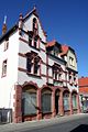
 Town hall
 -
 Museum
 -
 Former officers mess
 -
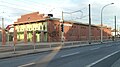 Former tram depot


-Museum.jpg)


See also
References
- ^ "Ergebnisse der jeweils letzten Direktwahl von Landrätinnen und Landräte sowie (Ober-)Bürgermeisterinnen und (Ober-)Bürgermeister in Hessen, Stand 13.04.2023" (in German). Hessisches Statistisches Landesamt. Archived from the original (XLS) on 2023-07-07. Retrieved 2023-07-06.
- ^ "Bevölkerung in Hessen am 31.12.2022 nach Gemeinden" (XLS) (in German). Hessisches Statistisches Landesamt. June 2023.
- ^ "Bevölkerung in Hessen". statistik.hessen.de (in German). Retrieved 2024-06-13.
- ^ "Karte vom Truppenübungsplatz 1910, 1:25000". Ernst-Moritz-Arndt-Universität Greifswald, Mathematisch-Naturwissenschaftliche Fakultät, Institut für Geographie und Geologie. 2013. Archived from the original on 2013-05-12. Retrieved 2013-07-14.
- ^ "Karte vom Truppenübungsplatz 1936, 1:25000". Ernst-Moritz-Arndt-Universität Greifswald, Mathematisch-Naturwissenschaftliche Fakultät, Institut für Geographie und Geologie. 2013. Archived from the original on 2013-05-12. Retrieved 2013-07-14.
- ^ Griesheim city museum
- ^ "Zwiebelmarkt: Griesheim".
- ^ a b "Städtepartner- und freundschaften". griesheim.de (in German). Griesheim. Retrieved 2021-03-10.
External links
- Official website
 (in German)
 - Weatherstats of Griesheim
Towns and municipalities in Darmstadt-Dieburg district | ||
|---|---|---|
 | ||
| International | |
|---|---|
| National | |
| Geographic | |