
Kirkcudbrightshire: Difference between revisions
→Notable Inhabitants: CC Edgar |
No edit summary Tags: Mobile edit Mobile web edit Advanced mobile edit |
||
| (45 intermediate revisions by 20 users not shown) | |||
| Line 1: | Line 1: | ||
{{ |
{{Other uses}} |
||
{{Use British English|date=November 2019}} |
{{Use British English|date=November 2019}} |
||
{{Use dmy dates|date=November 2019}} |
{{Use dmy dates|date=November 2019}} |
||
| Line 5: | Line 5: | ||
<!-- See Template:Infobox settlement for additional fields and descriptions --> |
<!-- See Template:Infobox settlement for additional fields and descriptions --> |
||
| name = Kirkcudbrightshire |
| name = Kirkcudbrightshire |
||
| native_name = |
| native_name = Kirkcoubrieshire |
||
| native_name_lang = <!-- ISO 639-2 code e.g. "fr" for French. If more than one, use {{lang}} instead --> |
| native_name_lang = sco<!-- ISO 639-2 code e.g. "fr" for French. If more than one, use {{lang}} instead --> |
||
| settlement_type = [[Shires of Scotland|Historic county]] |
| settlement_type = [[Shires of Scotland|Historic county]] |
||
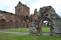
| image_skyline = |
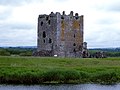
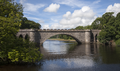
| image_skyline = File:Threave Castle (27343646418).jpg |
||
| image_alt = |
| image_alt = |
||
| image_caption = |
| image_caption = [[Threave Castle]], by the [[River Dee, Galloway|River Dee]] |
||
| image_flag = Flag of Kirkcudbrightshire.svg |
| image_flag = Flag of Kirkcudbrightshire.svg |
||
| flag_size = 150px |
| flag_size = 150px |
||
| flag_link = Flag of Kirkcudbrightshire |
| flag_link = Flag of Kirkcudbrightshire |
||
| flag_alt = |
|||
| image_seal = |
|||
| seal_alt = |
|||
| image_shield = |
|||
| shield_alt = |
|||
| nickname = |
|||
| motto = |
|||
| image_map = Kirkcudbrightshire - Scotland.svg |
| image_map = Kirkcudbrightshire - Scotland.svg |
||
| map_alt = |
|||
| map_caption = |
|||
| pushpin_map = |
|||
| pushpin_map_alt = |
|||
| pushpin_map_caption = |
|||
| coor_pinpoint = |
|||
| coordinates = |
|||
| coordinates_footnotes = |
|||
| subdivision_type = Country |
| subdivision_type = Country |
||
| subdivision_name = [[Scotland]] |
| subdivision_name = [[Scotland]] |
||
| subdivision_type1 = |
|||
| subdivision_name1 = |
|||
| subdivision_type2 = |
|||
| subdivision_name2 = |
|||
| established_title = |
|||
| established_date = |
|||
| founder = |
|||
| seat_type = [[County town]] |
| seat_type = [[County town]] |
||
| seat = [[Kirkcudbright]] |
| seat = [[Kirkcudbright]] |
||
| Line 51: | Line 29: | ||
| area_water_sq_mi = |
| area_water_sq_mi = |
||
| area_total_km2 = {{convert|899|sqmi|km2|disp=number|0}} |
| area_total_km2 = {{convert|899|sqmi|km2|disp=number|0}} |
||
| area_land_km2 = |
|||
| area_water_km2 = |
|||
| area_water_percent = |
|||
| area_note = Ranked 10th of 34 |
| area_note = Ranked 10th of 34 |
||
| elevation_footnotes = |
|||
| elevation_m = |
|||
| population_footnotes = |
|||
| population_total = |
|||
| population_as_of = |
|||
| population_density_km2 = auto |
| population_density_km2 = auto |
||
| population_demonym = |
|||
| population_note = |
|||
| timezone1 = |
|||
| utc_offset1 = |
|||
| timezone1_DST = |
|||
| utc_offset1_DST = |
|||
| postal_code_type = [[Chapman code]] |
| postal_code_type = [[Chapman code]] |
||
| postal_code = KKD |
| postal_code = KKD |
||
| area_code_type = |
|||
| area_code = |
|||
| iso_code = |
|||
| website = <!-- {{URL|example.com}} --> |
|||
| footnotes = |
|||
}} |
}} |
||
'''Kirkcudbrightshire''' ({{IPAc-en|k| |
'''Kirkcudbrightshire''' ({{IPAc-en|k|əːr|ˈ|k|uː|b|r|ɪ|ʃ|ər|,_|-|ʃ|ɪər}} {{respell|kur|KOO|brish|ər|,_-|eer}}; {{lang-sco|Kirkcoubrieshire}} {{IPA|sco|kɪrˈkubrɪʃər|}}), or the '''County of Kirkcudbright''' or '''the Stewartry of Kirkcudbright''' is one of the [[Counties of Scotland|historic counties of Scotland]], covering an area in the south-west of the country. Until 1975, Kirkcudbrightshire was an [[counties of Scotland|administrative county]] used for [[local government in Scotland|local government]]. Since 1975, the area has formed part of [[Dumfries and Galloway]] for local government purposes. Kirkcudbrightshire continues to be used as a [[registration county]] for land registration. A lower-tier [[districts of Scotland|district]] called [[Stewartry]] covered the majority of the historic county from 1975 to 1996. The area of Stewartry district is still used as a [[lieutenancy areas of Scotland|lieutenancy area]]. Dumfries and Galloway Council also has a Stewartry [[area committee]]. |
||
Ultimately meaning "shire of the church of [[Saint Cuthbert]]", Kirkcudbrightshire forms the eastern part of the medieval lordship of [[Galloway]], which retained a degree of autonomy until it was fully absorbed by Scotland in the 13th century. In 1369, the part of Galloway east of the [[River Cree]] was placed under the control of a steward based in [[Kirkcudbright]] and so that area became known as the "Stewartry of Kirkcudbright". The rest of Galloway remained under the authority of a [[Sheriff principal|sheriff]] based in [[Wigtown]], and so became known as [[Wigtownshire]]. Kirkcudbrightshire was occasionally referred to as East Galloway.<ref>The New Statistical Account of Scotland (1834)</ref> It is bounded on the north by [[Ayrshire]], on the west by Wigtownshire, on the south by the [[Irish Sea]] and [[Solway Firth]], and on the east by [[Dumfriesshire]]. The [[county town]] is Kirkcudbright. |
|||
It maintains a strong regional and distinct political identity. It formed a district in the Dumfries and Galloway [[regions and districts of Scotland|region]] and today the Stewartry is an [[area committee]] represented by eight councillors. Local administration of the area today is overseen by a Stewartry Area Manager, based in the [[county town]] of [[Kirkcudbright]]. The current [[Lord Lieutenant of Kirkcudbright]], the [[Elizabeth II of the United Kingdom|Crown]]'s representative in the area, is Elizabeth Patricia Gilroy. |
|||
==History== |
==History== |
||
===Early history=== |
===Early history=== |
||
| ⚫ | |||
| ⚫ | After [[Gnaeus Julius Agricola]]'s invasion in 79 AD, the country nominally formed part of the [[Roman Empire|Roman]] province of [[Britannia]], but the evidence is against there having been a prolonged effective Roman occupation. There was a Roman temporary marching camp at Shawhead, in Kirkpatrick Irongray.<ref>{{cite web|url=http://www.roman-britain.org/places/shawhead.htm |title=SHAWHEAD CAMPS |author=Togodumnus (Kevan White) |work=roman-britain.org |url-status=dead |archive-url=https://web.archive.org/web/20140106043108/http://www.roman-britain.org/places/shawhead.htm |archive-date=2014-01-06 }}</ref> |
||
| ⚫ | |||
| ⚫ | After the retreat of the Romans, the fate of the Novantae is unknown. By the 6th century, Galloway was part of the [[Britons (historical)|Brythonic]] [[kingdom of Strathclyde]].<ref>{{cite web|url=https://www.electricscotland.com/history/raiderland/gallowayinancienttimes.pdf |title=Galloway in ancient and modern times pg 62 |author=P. H: M'Kerlie}}</ref> |
||
| ⚫ | After [[Gnaeus Julius Agricola]]'s invasion in 79 AD, the country nominally formed part of the [[Roman Empire|Roman]] province of [[Britannia]], but the evidence is against there |
||
During the ninth century, the region was part of the [[Northumbria|Kingdom of Northumbria]]. A [[Talnotrie Hoard|hoard]] that has been attributed to either a Northumbrian metal-worker, or a Viking campaigner, was deposited near Talnotrie c.875-900.<ref>{{Cite journal|last=Graham-Campbell|first=James|date=1978|title=The Viking-age silver and gold hoards of Scandinavian character from Scotland|url=http://soas.is.ed.ac.uk/index.php/psas/article/view/8936|journal=Proceedings of the Society of Antiquaries of Scotland|language=en|volume=107|pages=114–135|doi=10.9750/PSAS.107.114.135 |s2cid=52252942 |issn=2056-743X|doi-access=free}}</ref><ref name=":3">{{Cite web|date=2021-09-22|title=Looting Scotland in the Viking Age {{!}} National Museums Scotland Blog|url=https://blog.nms.ac.uk/2020/07/21/looting-scotland-in-the-viking-age/|access-date=2021-09-22|archive-url=https://web.archive.org/web/20210922092230/https://blog.nms.ac.uk/2020/07/21/looting-scotland-in-the-viking-age/ |archive-date=22 September 2021 }}</ref><ref>{{Cite book|last=Thompson|first=J D A|title=Inventory of British Coin Hoards, AD 600-1500|publisher=Royal Numismatic Society|year=1956|location=London|pages=132}}</ref> |
|||
| ⚫ | After the retreat of the Romans, the fate of the Novantae is unknown. |
||
===11th, 12th, and 13th centuries=== |
===11th, 12th, and 13th centuries=== |
||
| ⚫ | |||
[[File:NW Britain 11th cent.jpg|300px|thumb|right|Kirkcudbrightshire 11th century]] |
|||
| ⚫ | |||
After [[Malcolm III of Scotland|Malcolm Canmore]] defeated and killed [[Macbeth of Scotland|Macbeth]] in 1057, he married the dead king's relative, Ingibiorg, a Pictish princess, (the view that there were [[Picts]] in Galloway in historical times cannot be wholly rejected) an event which marked the beginning of the decay of Norse influence. The Galloway chiefs became lieges of the Scottish king, whilst retaining some independence as the sub-kingdom or semi-autonomous [[Lordship of Galloway]]. Following the death of Lord [[Alan of Galloway]] in 1234 the area was brought fully under the control of the Scottish crown.<ref name=Learmonth>{{cite book |last1=Learmonth |first1=William |title=Kirkcudbrightshire and Wigtownshire |date=1920 |publisher=Cambridge University Press |location=Cambridge |page=1 |url=https://archive.org/details/kirkcudbrightshi00learuoft/page/n15/mode/2up |access-date=27 November 2022}}</ref> |
|||
===14th and 15th centuries=== |
===14th and 15th centuries=== |
||
In 1308 the district was cleared of the English and brought under allegiance to the king, when the lordship of Galloway was given to [[Edward Bruce]]. |
In 1308 the district was cleared of the English and brought under allegiance to the king, when the lordship of Galloway was given to [[Edward Bruce]]. |
||
In |
In 1369 [[Archibald the Grim]], [[Earl of Douglas]], was given the part of Galloway east of the [[River Cree]], where he appointed a steward to administer the area, which became known as the Stewartry of Kirkcudbright. The following year, he acquired the rest of Galloway west of the Cree, which continued to be administered by the king's sheriff, and so became known as the Shire of Wigtown. This led to the local custom of referring to Kirkcudbrightshire as ''"The Stewartry"'' and [[Wigtownshire]] as ''"The Shire"'', which continued into the 20th century.<ref name=Learmonth/><ref>{{cite web|url=http://www.kirkcudbright.co.uk/history.asp |title=Visit Kirkcudbright – Historical Sites |publisher=Kirkcudbright.co.uk |access-date=2013-01-20}}</ref> |
||
In 1455 [[Threave Castle]], the most important fortress in Galloway, which Archibald the Grim had built on the Dee immediately to the west of the modern town of [[Castle Douglas]], was reduced and converted into a royal keep.{{ |
In 1455 [[Threave Castle]], the most important fortress in Galloway, which Archibald the Grim had built on the Dee immediately to the west of the modern town of [[Castle Douglas]], was reduced and converted into a royal keep.{{citation needed|date=December 2020}} |
||
===16th and 17th centuries=== |
===16th and 17th centuries=== |
||
As the Douglases went down the Maxwells rose, and the debatable land on the south-east of Dumfriesshire was for generations the scene of strife and raid, not only between the two nations but also among the leading families, of whom the Maxwells, Johnstones and Armstrongs were always conspicuous. After the [[Battle of Solway Moss]] (1542) the shires of Kirkcudbright and Dumfries fell under English rule for a short period. The treaty of [[Norham]] (24 March 1550) established a truce between the nations for ten years; and in 1552, the [[Warden of the March|Wardens of the Marches]] consenting, the debatable land ceased to be matter for debate, the parish of Canonbie being annexed to Dumfriesshire, that of Kirkandrews to [[Cumberland, England|Cumberland]].{{ |
As the Douglases went down the Maxwells rose, and the debatable land on the south-east of Dumfriesshire was for generations the scene of strife and raid, not only between the two nations but also among the leading families, of whom the Maxwells, Johnstones and Armstrongs were always conspicuous. After the [[Battle of Solway Moss]] (1542) the shires of Kirkcudbright and Dumfries fell under English rule for a short period. The treaty of [[Norham]] (24 March 1550) established a truce between the nations for ten years; and in 1552, the [[Warden of the March|Wardens of the Marches]] consenting, the debatable land ceased to be matter for debate, the parish of Canonbie being annexed to Dumfriesshire, that of Kirkandrews to [[Cumberland, England|Cumberland]].{{citation needed|date=December 2020}} |
||
===18th century=== |
===18th century=== |
||
[[Clan McCulloch|McCulloch]] and Gordon families were of ''Cardoness Castle, Anwoth Parish'' and Rev. [[Samuel Rutherford|Rutherford]]<ref>{{Cite web |url=http://www.fpchurch.org.uk/magazines/fpm/2003/January/article3.php |title= |
[[Clan McCulloch|McCulloch]] and Gordon families were of ''Cardoness Castle, Anwoth Parish'' and Rev. [[Samuel Rutherford|Rutherford]]<ref>{{Cite web |url=http://www.fpchurch.org.uk/magazines/fpm/2003/January/article3.php |title=Samuel Rutherford - Fair Anwoth by the Solway - 1627 - 1636 |access-date=22 February 2014 |archive-url=https://web.archive.org/web/20140227151842/http://www.fpchurch.org.uk/magazines/fpm/2003/January/article3.php |archive-date=27 February 2014 |url-status=dead }}</ref> was minister of [[Anwoth]]. |
||
After the [[Act of Union 1707|union]] (1707) things mended slowly but surely, curious evidence of growing commercial prosperity being the enormous extent to which smuggling was carried on. No coast could serve the "free traders" better than the shores of Kirkcudbright, and the contraband trade flourished until the 19th century. The [[Jacobitism|Jacobite]] risings [[Jacobite rising of 1715|of 1715]] [[Jacobite rising of 1745|and 1745]] elicited small sympathy from the inhabitants of the shire. In the 1760s a [[Old military roads of Scotland|military road]] was constructed from Bridge of Sark,<ref>{{cite web|url=http://canmoremapping.rcahms.gov.uk/index.php?action=do_advanced&idnumlink=142606|title=Welcome to Canmore – Canmore|work=rcahms.gov.uk}}</ref> near [[Gretna, Dumfries and Galloway]] to [[Portpatrick]] by [[Major William Caulfeild]]. |
After the [[Act of Union 1707|union]] (1707) things mended slowly but surely, curious evidence of growing commercial prosperity being the enormous extent to which smuggling was carried on. No coast could serve the "free traders" better than the shores of Kirkcudbright, and the contraband trade flourished until the 19th century. The [[Jacobitism|Jacobite]] risings [[Jacobite rising of 1715|of 1715]] [[Jacobite rising of 1745|and 1745]] elicited small sympathy from the inhabitants of the shire. In the 1760s a [[Old military roads of Scotland|military road]] was constructed from Bridge of Sark,<ref>{{cite web|url=http://canmoremapping.rcahms.gov.uk/index.php?action=do_advanced&idnumlink=142606|title=Welcome to Canmore – Canmore|work=rcahms.gov.uk}}</ref> near [[Gretna, Dumfries and Galloway]] to [[Portpatrick]] by [[Major William Caulfeild]]. |
||
===19th century=== |
|||
[[File:High Street, Kirkcudbright (geograph 3686669).jpg|thumb|[[County Buildings, Kirkcudbright|121–123 High Street, Kirkcudbright]]: Former headquarters of Kirkcudbrightshire County Council]] |
|||
Elected county councils were established in Scotland in 1890 under the [[Local Government (Scotland) Act 1889]]. Kirkcudbrightshire County Council established its headquarters at [[County Buildings, Kirkcudbright|County Buildings, 121–123 High Street, Kirkcudbright]], being a converted pair of late 18th century houses. A large extension was built in 1952 to the rear of the building facing Daar Road.<ref>{{Historic Environment Scotland|num= LB36523|desc= County Buildings, 121, 123 High Street, Kirkcudbright|access-date=18 July 2021}}</ref> |
|||
Kirkcudbrightshire was abolished as an administrative county in 1975 under the [[Local Government (Scotland) Act 1973]]. A two-tier system of regions and districts was put in place instead, with the area becoming part of the [[Dumfries and Galloway]] region. Most of Kirkudbrightshire became part of the [[Stewartry]] district. The two [[list of civil parishes in Scotland|parishes]] of [[Kirkmabreck]] and [[Minnigaff]] in the west of the county went instead to the [[Wigtown Area|Wigtown]] district, whilst the five parishes of [[Kirkbean]], Kirkpatrick Irongray, [[New Abbey]], [[Terregles]], and [[Troqueer]] in the east of the county went to the [[Nithsdale]] district.<ref>{{cite legislation UK|type=act|act=Local Government (Scotland) Act 1973|year=1973|chapter=65|accessdate=22 November 2022}}</ref> |
|||
Further local government reform in 1996 saw the Stewartry, Wigtown and Nithsdale districts abolished and their functions passed to Dumfries and Galloway Council, which continues to operate [[area committee]]s based on the pre-1996 districts, subject to some boundary changes where ward boundaries no longer follow the pre-1996 district boundaries.<ref>{{cite web |title=Stewartry Area Committee |url=https://dumfriesgalloway.moderngov.co.uk/mgCommitteeDetails.aspx?ID=135 |website=Dumfries and Galloway Council |access-date=2 December 2022}}</ref> The former Stewartry district is used as a [[Lieutenancy areas of Scotland|lieutenancy area]] under the name the Stewartry of Kirkcudbright.<ref>{{cite legislation UK|type=si|si=The Lord-Lieutenants (Scotland) Order 1996|year=1996|number=731|accessdate=25 November 2022}}</ref> |
|||
==Geography== |
==Geography== |
||
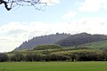
[[File:Rhinns of Kells ridge towards Millfire - geograph.org.uk - 207497.jpg|thumb|Rhinns of Kells ridge towards [[Millfire]]]] |
[[File:Rhinns of Kells ridge towards Millfire - geograph.org.uk - 207497.jpg|thumb|Rhinns of Kells ridge towards [[Millfire]]]] |
||
Kirkcudbrightshire has a shoreline on the [[Solway Firth]], between the rivers [[River Nith|Nith]] and [[River Cree|Cree]]. Inland, the area has many hills, with its highest point being [[Merrick, Galloway|Merrick]] {{convert|843|m|ft}}.<ref>{{cite web |title=Kirkcudbrightshire |url=https://www.britannica.com/place/Kirkcudbrightshire |publisher=[[Encyclopaedia Britannica]] |access-date=31 December 2020}}</ref> |
|||
There are many "burns" and "waters", but their length seldom exceeds 7 |
There are many "burns" and "waters", but their length seldom exceeds {{convert|7|or|8|mi|km|0|abbr=off}}. Among the longer rivers are the Cree, which rises in [[Loch Moan]] and reaches the sea near Creetown after a course of about {{convert|30|mi|km|-1|abbr=off}}; the Dee or Black Water of Dee (so named from the peat by which it is coloured), which rises in [[Loch Dee]] which after a course mainly S.E. and finally S., enters the sea at [[St Mary's Isle Priory|St Mary's Isle]] below [[Kirkcudbright]], its length being nearly {{convert|36|mi|km|abbr=off}}; the Urr, rising in [[Loch Urr]] on the [[Dumfriesshire]] border, falls into the sea a few miles south of [[Dalbeattie]] {{convert|27|mi|km|abbr=off}} from its source. |
||
===Geology=== |
===Geology=== |
||
| Line 128: | Line 93: | ||
Brick-red sandstones of [[Permian]] age just come within the county on the W. side of the Nith at Dumfries. Volcanic necks occur in the Permian and basalt dikes penetrate the Silurian at Borgue, Kirkandrews, etc. |
Brick-red sandstones of [[Permian]] age just come within the county on the W. side of the Nith at Dumfries. Volcanic necks occur in the Permian and basalt dikes penetrate the Silurian at Borgue, Kirkandrews, etc. |
||
Most of the highest ground is formed by |
Most of the highest ground is formed by [[granite]] [[Igneous intrusion|plutons]] which have been intruded into the Ordovician and Silurian rocks; the Criffel pluton lies about [[Dalbeattie]] and Bengairn, another mass extends east and west between the Cairnsmore of Fleet and [[Loch Ken]], another lies north-west and south-east between [[Loch Doon]] and Loch Dee and a small mass forms the Cairnsmore of [[Carsphairn]]. Much granite was quarried from Kirkmabreck, near [[Creetown]] for dock construction from 1830 on.<ref>{{cite web|url=http://www.dalbeattie.com/scotland-creetown/quarries/|title=Scotland, Creetown – Quarry at Kirkmabreck|work=dalbeattie.com}}</ref> |
||
[[Glacial]] deposits occupy much of the low ground; the ice, having travelled in a southerly or south-easterly direction, has left abundant striae on the higher ground to indicate its course. Radiation of the ice streams took place from the heights of Merrick, Kells, etc.; local moraines are found near [[Carsphairn]] and in the Deagh and Minnoch valleys. Glacial [[drumlin]]s of boulder clay lie in the vales of the Dee, Cree and Urr. |
[[Glacial]] deposits occupy much of the low ground; the ice, having travelled in a southerly or south-easterly direction, has left abundant striae on the higher ground to indicate its course. Radiation of the ice streams took place from the heights of Merrick, Kells, etc.; local moraines are found near [[Carsphairn]] and in the Deagh and Minnoch valleys. Glacial [[drumlin]]s of boulder clay lie in the vales of the Dee, Cree and Urr. |
||
===Climate and agriculture=== |
===Climate and agriculture=== |
||
The climate and soil suit grass and green crops rather than grain. The annual rainfall averages {{convert|1160|mm|in|1}}. The mean temperature for the year is 9 °C (48 °F); for |
The climate and soil suit grass and green crops rather than grain. The annual rainfall averages {{convert|1160|mm|in|1}}. The mean temperature for the year is 9 °C (48 °F); for January 4 °C (39 °F)and 15 °C (59 °F) for July. |
||
==Railways== |
==Railways== |
||
| Line 153: | Line 118: | ||
*[[Crossmichael]] |
*[[Crossmichael]] |
||
*[[St. John's Town of Dalry|Dalry]] |
*[[St. John's Town of Dalry|Dalry]] |
||
*[[Girthon]], see also [[Gatehouse of Fleet]] and [[Cally Palace]]<ref>Civil Parish of Girthon map. http://www.scottish-places.info/parishes/parmap1044.html</ref><ref>A Topographical Dictionary of Scotland |
*[[Girthon]], see also [[Gatehouse of Fleet]] and [[Cally Palace]]<ref>{{cite web|title=Civil Parish of Girthon map. |url=http://www.scottish-places.info/parishes/parmap1044.html}}</ref><ref>{{cite web|title=A Topographical Dictionary of Scotland|first= Samuel |last=Lewis|volume=1|year= 1851|pages=490–491|url= https://archive.org/stream/topographicaldic01lewi#page/490/mode/2up}}</ref><ref>{{cite web|url=http://www.kirkcudbright.co/girthon/lands.asp |title=Parish of Girthon – History of the Lands and Their Owners in Galloway |publisher=Kirkcudbright.co |access-date=2013-01-20}}</ref> |
||
*[[Kells, Dumfries and Galloway|Kells]]<ref>{{cite web|url=http://www.scottish-places.info/parishes/parmap1014.html |title=Parish of Kells Map |publisher=Scottish-places.info |access-date=2013-01-20}}</ref> |
|||
| ⚫ | *[[Irongray]]<ref>Scotlands Places |
||
*[[ |
*[[Kelton, Galloway|Kelton]]<ref>{{cite web|publisher=Caledonia|volume=3 |first= George |last=Chalmers|year= 1824|page=314|title= Parish of Kelton|url=https://archive.org/stream/caledoniaoraccou03chal#page/314/mode/1up}}</ref><ref>{{cite web|url=http://www.kirkcudbright.co/kelton.asp |title=The Parish of Kelton |publisher=Kirkcudbright.co |access-date=2013-01-20}}</ref> |
||
| ⚫ | *[[ |
||
*[[Kirkbean]] |
*[[Kirkbean]] |
||
*[[Kirkcudbright]] |
*[[Kirkcudbright]] |
||
*[[Kirkgunzeon]]<ref>A Topographical Dictionary of Scotland |
*[[Kirkgunzeon]]<ref>{{cite web|title=A Topographical Dictionary of Scotland|first= Samuel |last=Lewis|volume=2| year= 1851|pages=106–107 |url=https://archive.org/stream/topographicaldic02lewi#page/106/mode/2up}}</ref><ref>{{cite web|url=http://www.kirkcudbright.co/kirkgunzeon.asp |title=The Parish of Kirkgunzeon |publisher=Kirkcudbright.co |access-date=2013-01-20}}</ref> |
||
*[[Kirkmabreck]]<ref>A Topographical Dictionary of Scotland |
*[[Kirkmabreck]]<ref>{{cite web|title=A Topographical Dictionary of Scotland|first=Samuel|last=Lewis|volume=2 |year=1851|pages=112–113|url= https://archive.org/stream/topographicaldic02lewi#page/112/mode/2up}}</ref><ref>{{cite web|url=http://www.kirkcudbright.co/kirkmabreck.asp |title=The Parish of Kirkmabreck |publisher=Kirkcudbright.co |access-date=2013-01-20}}</ref> |
||
*[[Kirkpatrick Durham]] |
*[[Kirkpatrick Durham]] |
||
| ⚫ | *[[Kirpatrick Irongray]] (or Irongray)<ref>{{cite web|title=Irongray|publisher=Scotlands Places|url=http://www.scotlandsplaces.gov.uk/search/?action=do_search&p_type=PARISH&p_name=kirkpatrick_irongray&id=1014&p_county=kirkcudbrightshire|access-date=16 April 2013|archive-date=9 November 2012|archive-url=http://webarchive.nationalarchives.gov.uk/20121109120426/http%3A//www.scotlandsplaces.gov.uk/search/?action%3Ddo_search%26p_type%3DPARISH%26p_name%3Dkirkpatrick_irongray%26id%3D1014%26p_county%3Dkirkcudbrightshire|url-status=dead}} {{Cite web |url=http://www.scotlandsplaces.gov.uk/search/?action=do_search&p_type=PARISH&p_name=kirkpatrick_irongray&id=1014&p_county=kirkcudbrightshire |title=Archived copy |access-date=16 April 2013 |archive-date=9 November 2012 |archive-url=http://webarchive.nationalarchives.gov.uk/20121109120426/http%3A//www.scotlandsplaces.gov.uk/search/?action%3Ddo_search%26p_type%3DPARISH%26p_name%3Dkirkpatrick_irongray%26id%3D1014%26p_county%3Dkirkcudbrightshire |url-status=bot: unknown }}</ref><ref>{{cite web|title=A Topographical Dictionary of Scotland|first= Samuel|last= Lewis|volume=2|year=1851|page=125 |url=https://archive.org/stream/topographicaldic02lewi#page/125/mode/1up}}</ref><ref>{{cite web|title=Statistical Account|year= 1792 |url=https://archive.org/stream/statisticalacco09sincgoog#page/n533/mode/2up}}</ref> |
||
*[[Lochrutton]]<ref>A Topographical Dictionary of Scotland. by Samuel Lewis. Vol.II. Second Edition. Pub. 1851. pp.200-201 https://archive.org/stream/topographicaldic02lewi#page/200/mode/2up</ref><ref>{{cite web|url=http://www.kirkcudbright.co/lochrutton.asp |title=The Parish of Lochrutton |publisher=Kirkcudbright.co |access-date=2013-01-20}}</ref> |
|||
| ⚫ | *[[Lochrutton]]<ref>{{cite web|title=A Topographical Dictionary of Scotland|first=Samuel |last=Lewis|volume=2|year= 1851|pages=200–201 |url=https://archive.org/stream/topographicaldic02lewi#page/200/mode/2up}}</ref><ref>{{cite web|url=http://www.kirkcudbright.co/lochrutton.asp |title=The Parish of Lochrutton |publisher=Kirkcudbright.co |access-date=2013-01-20}}</ref> |
||
*[[Minnigaff]] |
*[[Minnigaff]] |
||
*[[New Abbey]] |
*[[New Abbey]] |
||
*[[Parton, Galloway|Parton]] |
*[[Parton, Galloway|Parton]] |
||
*[[Rerrick]]<ref>A Topographical Dictionary of Scotland |
*[[Rerrick]]<ref>{{cite web|title=A Topographical Dictionary of Scotland|first= Samuel|last= Lewis|volume=2|year= 1851|pages=415–416|url= https://archive.org/stream/topographicaldic02lewi#page/414/mode/2up}}</ref><ref>{{cite web|url=http://www.kirkyards.co.uk/rerrick.asp |title=The Parish of Rerrick |publisher=Kirkyards.co.uk |access-date=2013-01-20}}</ref> |
||
*[[Terregles]] |
*[[Terregles]] |
||
*[[Tongland]] |
*[[Tongland]] |
||
| Line 233: | Line 198: | ||
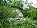
File:Sweetheart Abbey entrance.jpg|Remains of [[Sweetheart Abbey]] |
File:Sweetheart Abbey entrance.jpg|Remains of [[Sweetheart Abbey]] |
||
File:Tongland Bridge August 2013.png|Bridge over the Dee at Tongland |
File:Tongland Bridge August 2013.png|Bridge over the Dee at Tongland |
||
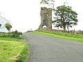
File:The Doon and old fort West of Twynholm.jpg|Hillfort near |
File:The Doon and old fort West of Twynholm.jpg|Hillfort near Twynholm |
||
</gallery> |
</gallery> |
||
| Line 241: | Line 206: | ||
*[[Archibald Douglas, 3rd Earl of Douglas|Archibald the Grim]], Lord of Galloway and Earl of Douglas |
*[[Archibald Douglas, 3rd Earl of Douglas|Archibald the Grim]], Lord of Galloway and Earl of Douglas |
||
*[[Malcolm Caldwell]], Marxist writer, chair of the Campaign for Nuclear Disarmament |
*[[Malcolm Caldwell]], Marxist writer, chair of the Campaign for Nuclear Disarmament |
||
*[[James Clerk Maxwell]], |
*[[James Clerk Maxwell]], 19th century physicist |
||
* |
*[[David Coulthard]], Formula 1 Grand Prix winner from [[Twynholm]] |
||
*[[S. R. |
*[[S. R. Crockett]], Minister and novelist |
||
*[[Dervorguilla of Galloway|Devorguilla]], Mother of John I, king of Scotland |
*[[Dervorguilla of Galloway|Devorguilla]], Mother of John I, king of Scotland |
||
*[[Sir William Douglas, 1st Baronet|Sir William Douglas]], Founded the town of Castle Douglas |
*[[Sir William Douglas, 1st Baronet|Sir William Douglas]], Founded the town of Castle Douglas |
||
| Line 251: | Line 216: | ||
*[[Margaret McNaughton]], Scottish Canadian writer |
*[[Margaret McNaughton]], Scottish Canadian writer |
||
*[[Alexander Murray (linguist)|Alexander Murray]], Edinburgh University professor |
*[[Alexander Murray (linguist)|Alexander Murray]], Edinburgh University professor |
||
*[[John Welsh of Irongray]], leader of the [[Scottish Covenanter]] Movement |
|||
| ⚫ | |||
{{Reflist}} |
|||
==Further reading== |
|||
| ⚫ | |||
{{reflist}} |
|||
* Sir Herbert Maxwell, ''History of Dumfries and Galloway'' (Edinburgh, 1896) |
* Sir Herbert Maxwell, ''History of Dumfries and Galloway'' (Edinburgh, 1896) |
||
* Rev. Andrew Symson, ''A Large Description of Galloway'' (1684; new ed., 1823) https://books.google.com/books?id=4mYLAAAAYAAJ |
* Rev. Andrew Symson, ''A Large Description of Galloway'' (1684; new ed., 1823) [https://books.google.com/books?id=4mYLAAAAYAAJ&q=Dalry A large description of Galloway [ed. by T. Maitland].] |
||
* [[Thomas Murray (writer)|Thomas Murray]], ''The Literary History of Galloway'' (1822) |
* [[Thomas Murray (writer)|Thomas Murray]], ''The Literary History of Galloway'' (1822) |
||
* Rev. William Mackenzie, ''History of Galloway'' (1841) |
* Rev. William Mackenzie, ''History of Galloway'' (1841) |
||
| Line 268: | Line 236: | ||
{{EB1911|wstitle=Kirkcudbrightshire}} |
{{EB1911|wstitle=Kirkcudbrightshire}} |
||
{{Scotland counties}} |
{{Scotland counties}} |
||
{{Authority control}} |
|||
{{ |
{{Coord|55|00|N|4|00|W|region:GB_type:adm2nd_source:GNS-enwiki|display=title}} |
||
[[Category:Kirkcudbrightshire| ]] |
[[Category:Kirkcudbrightshire| ]] |
||
[[Category:Counties of Scotland]] |
[[Category:Counties of Scotland]] |
||
[[Category:Lieutenancy areas of Scotland]] |
|||
[[Category:Galloway]] |
[[Category:Galloway]] |
||
[[Category:Counties of the United Kingdom (1801–1922)]] |
[[Category:Counties of the United Kingdom (1801–1922)]] |
||
Latest revision as of 17:18, 15 July 2024
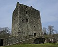
Kirkcudbrightshire
Kirkcoubrieshire | |
|---|---|
.jpg) Threave Castle, by the River Dee | |
 | |
| Country | Scotland |
| County town | Kirkcudbright |
| Area | |
| • Total | 899 sq mi (2,328 km2) |
| Ranked 10th of 34 | |
| Chapman code | KKD |

Kirkcudbrightshire (/kɜːrˈkuːbrɪʃər, -ʃɪər/ kur-KOO-brish-ər, -eer; Scots: Kirkcoubrieshire [kɪrˈkubrɪʃər]), or the County of Kirkcudbright or the Stewartry of Kirkcudbright is one of the historic counties of Scotland, covering an area in the south-west of the country. Until 1975, Kirkcudbrightshire was an administrative county used for local government. Since 1975, the area has formed part of Dumfries and Galloway for local government purposes. Kirkcudbrightshire continues to be used as a registration county for land registration. A lower-tier district called Stewartry covered the majority of the historic county from 1975 to 1996. The area of Stewartry district is still used as a lieutenancy area. Dumfries and Galloway Council also has a Stewartry area committee.
Ultimately meaning "shire of the church of Saint Cuthbert", Kirkcudbrightshire forms the eastern part of the medieval lordship of Galloway, which retained a degree of autonomy until it was fully absorbed by Scotland in the 13th century. In 1369, the part of Galloway east of the River Cree was placed under the control of a steward based in Kirkcudbright and so that area became known as the "Stewartry of Kirkcudbright". The rest of Galloway remained under the authority of a sheriff based in Wigtown, and so became known as Wigtownshire. Kirkcudbrightshire was occasionally referred to as East Galloway.[1] It is bounded on the north by Ayrshire, on the west by Wigtownshire, on the south by the Irish Sea and Solway Firth, and on the east by Dumfriesshire. The county town is Kirkcudbright.
History
[edit]Early history
[edit]The country west of the Nith was originally peopled by a tribe of Celts called Novantae, who long retained their independence.[citation needed]
After Gnaeus Julius Agricola's invasion in 79 AD, the country nominally formed part of the Roman province of Britannia, but the evidence is against there having been a prolonged effective Roman occupation. There was a Roman temporary marching camp at Shawhead, in Kirkpatrick Irongray.[2]
After the retreat of the Romans, the fate of the Novantae is unknown. By the 6th century, Galloway was part of the Brythonic kingdom of Strathclyde.[3]
During the ninth century, the region was part of the Kingdom of Northumbria. A hoard that has been attributed to either a Northumbrian metal-worker, or a Viking campaigner, was deposited near Talnotrie c.875-900.[4][5][6]
11th, 12th, and 13th centuries
[edit]During the next two hundred years the area was subject to incursions by Danes, Saxons and Scandinavians.[citation needed]
After Malcolm Canmore defeated and killed Macbeth in 1057, he married the dead king's relative, Ingibiorg, a Pictish princess, (the view that there were Picts in Galloway in historical times cannot be wholly rejected) an event which marked the beginning of the decay of Norse influence. The Galloway chiefs became lieges of the Scottish king, whilst retaining some independence as the sub-kingdom or semi-autonomous Lordship of Galloway. Following the death of Lord Alan of Galloway in 1234 the area was brought fully under the control of the Scottish crown.[7]
14th and 15th centuries
[edit]In 1308 the district was cleared of the English and brought under allegiance to the king, when the lordship of Galloway was given to Edward Bruce.
In 1369 Archibald the Grim, Earl of Douglas, was given the part of Galloway east of the River Cree, where he appointed a steward to administer the area, which became known as the Stewartry of Kirkcudbright. The following year, he acquired the rest of Galloway west of the Cree, which continued to be administered by the king's sheriff, and so became known as the Shire of Wigtown. This led to the local custom of referring to Kirkcudbrightshire as "The Stewartry" and Wigtownshire as "The Shire", which continued into the 20th century.[7][8]
In 1455 Threave Castle, the most important fortress in Galloway, which Archibald the Grim had built on the Dee immediately to the west of the modern town of Castle Douglas, was reduced and converted into a royal keep.[citation needed]
16th and 17th centuries
[edit]As the Douglases went down the Maxwells rose, and the debatable land on the south-east of Dumfriesshire was for generations the scene of strife and raid, not only between the two nations but also among the leading families, of whom the Maxwells, Johnstones and Armstrongs were always conspicuous. After the Battle of Solway Moss (1542) the shires of Kirkcudbright and Dumfries fell under English rule for a short period. The treaty of Norham (24 March 1550) established a truce between the nations for ten years; and in 1552, the Wardens of the Marches consenting, the debatable land ceased to be matter for debate, the parish of Canonbie being annexed to Dumfriesshire, that of Kirkandrews to Cumberland.[citation needed]
18th century
[edit]McCulloch and Gordon families were of Cardoness Castle, Anwoth Parish and Rev. Rutherford[9] was minister of Anwoth.
After the union (1707) things mended slowly but surely, curious evidence of growing commercial prosperity being the enormous extent to which smuggling was carried on. No coast could serve the "free traders" better than the shores of Kirkcudbright, and the contraband trade flourished until the 19th century. The Jacobite risings of 1715 and 1745 elicited small sympathy from the inhabitants of the shire. In the 1760s a military road was constructed from Bridge of Sark,[10] near Gretna, Dumfries and Galloway to Portpatrick by Major William Caulfeild.
19th century
[edit].jpg)
Elected county councils were established in Scotland in 1890 under the Local Government (Scotland) Act 1889. Kirkcudbrightshire County Council established its headquarters at County Buildings, 121–123 High Street, Kirkcudbright, being a converted pair of late 18th century houses. A large extension was built in 1952 to the rear of the building facing Daar Road.[11]
Kirkcudbrightshire was abolished as an administrative county in 1975 under the Local Government (Scotland) Act 1973. A two-tier system of regions and districts was put in place instead, with the area becoming part of the Dumfries and Galloway region. Most of Kirkudbrightshire became part of the Stewartry district. The two parishes of Kirkmabreck and Minnigaff in the west of the county went instead to the Wigtown district, whilst the five parishes of Kirkbean, Kirkpatrick Irongray, New Abbey, Terregles, and Troqueer in the east of the county went to the Nithsdale district.[12]
Further local government reform in 1996 saw the Stewartry, Wigtown and Nithsdale districts abolished and their functions passed to Dumfries and Galloway Council, which continues to operate area committees based on the pre-1996 districts, subject to some boundary changes where ward boundaries no longer follow the pre-1996 district boundaries.[13] The former Stewartry district is used as a lieutenancy area under the name the Stewartry of Kirkcudbright.[14]
Geography
[edit]
Kirkcudbrightshire has a shoreline on the Solway Firth, between the rivers Nith and Cree. Inland, the area has many hills, with its highest point being Merrick 843 metres (2,766 ft).[15]
There are many "burns" and "waters", but their length seldom exceeds 7 or 8 miles (11 or 13 kilometres). Among the longer rivers are the Cree, which rises in Loch Moan and reaches the sea near Creetown after a course of about 30 miles (50 kilometres); the Dee or Black Water of Dee (so named from the peat by which it is coloured), which rises in Loch Dee which after a course mainly S.E. and finally S., enters the sea at St Mary's Isle below Kirkcudbright, its length being nearly 36 miles (58 kilometres); the Urr, rising in Loch Urr on the Dumfriesshire border, falls into the sea a few miles south of Dalbeattie 27 miles (43 kilometres) from its source.
Geology
[edit]
Silurian and Ordovician rocks are the most important in this county; they are thrown into oft-repeated folds with their axes lying in a north-east–south-west direction. The Ordovician rocks are graptolitic black shales and grits of Llandeilo and Caradoc age. They occupy all the northern part of the county north-west of a line which runs some 3 m. north of New Galloway and just south of the Rinns of Kells. South-east of this line graptolitic Silurian shales of Llandovery age prevail; they are found around Dalry, Creetown, New Galloway, Castle Douglas and Kirkcudbright.
Overlying the Llandovery beds on the south coast are strips of Wenlock rocks; they extend from Bridgehouse Bay to Auchinleck and are well exposed in Kirkcudbright Bay, and they can be traced farther round the coast between the granite and the younger rocks. Carboniferous rocks appear in small faulted tracts, unconformable on the Silurian, on the shores of the Solway Firth. They are best developed about Kirkbean, where they include a basal red breccia followed by conglomerates, grits and cement stones of Calciferous Sandstone age.
Brick-red sandstones of Permian age just come within the county on the W. side of the Nith at Dumfries. Volcanic necks occur in the Permian and basalt dikes penetrate the Silurian at Borgue, Kirkandrews, etc.
Most of the highest ground is formed by granite plutons which have been intruded into the Ordovician and Silurian rocks; the Criffel pluton lies about Dalbeattie and Bengairn, another mass extends east and west between the Cairnsmore of Fleet and Loch Ken, another lies north-west and south-east between Loch Doon and Loch Dee and a small mass forms the Cairnsmore of Carsphairn. Much granite was quarried from Kirkmabreck, near Creetown for dock construction from 1830 on.[16]
Glacial deposits occupy much of the low ground; the ice, having travelled in a southerly or south-easterly direction, has left abundant striae on the higher ground to indicate its course. Radiation of the ice streams took place from the heights of Merrick, Kells, etc.; local moraines are found near Carsphairn and in the Deagh and Minnoch valleys. Glacial drumlins of boulder clay lie in the vales of the Dee, Cree and Urr.
Climate and agriculture
[edit]The climate and soil suit grass and green crops rather than grain. The annual rainfall averages 1,160 millimetres (45.7 in). The mean temperature for the year is 9 °C (48 °F); for January 4 °C (39 °F)and 15 °C (59 °F) for July.
Railways
[edit]
Castle Douglas and Dumfries Railway was incorporated on 21 July 1856; the act was obtained by the Glasgow and South Western Railway.[17] It opened on 7 November 1859 and was substantially closed, under the Beeching cuts, on 14 June 1965.[17] The Portpatrick Railway was authorised on 10 August 1857. By 12 March 1861, the line connected Stranraer to Castle Douglas, where it joined the newly constructed Castle Douglas and Dumfries railway.[17] The branch to Portpatrick opened the following year, on 28 August 1862, with the Stranraer Harbour branch, which opened on 1 October 1862; although building work continued on the line for another five years.[17] The Kirkcudbright Railway was a railway branch line linking Kirkcudbright to the Castle Douglas and Dumfries Railway at Castle Douglas. It opened in 1864, and closed in 1965.
The Beeching cuts cut off the Castle Douglas and Dumfries Railway and Portpatrick Railway in 1965 resulting in an adverse mileage increase via the Glasgow South Western Line to reach Stranraer Harbour (for Larne Harbour and Port of Belfast) from Dumfries, Carlisle and the West Coast Main Line to London Euston, and leaving the county without any railway permanent way.
List of parishes
[edit]
The Stewartry is composed of the following 28 civil parishes.[19]
- Anwoth
- Balmaclellan
- Balmaghie
- Borgue
- Buittle
- Carsphairn
- Colvend and Southwick[20]
- Crossmichael
- Dalry
- Girthon, see also Gatehouse of Fleet and Cally Palace[21][22][23]
- Kells[24]
- Kelton[25][26]
- Kirkbean
- Kirkcudbright
- Kirkgunzeon[27][28]
- Kirkmabreck[29][30]
- Kirkpatrick Durham
- Kirpatrick Irongray (or Irongray)[31][32][33]
- Lochrutton[34][35]
- Minnigaff
- New Abbey
- Parton
- Rerrick[36][37]
- Terregles
- Tongland
- Troqueer
- Twynholm
- Urr
Towns and villages
[edit]


- Auchencairn
- Balmaclellan
- Beeswing
- Borgue
- Bridge of Dee
- Cargenbridge
- Carsethorn
- Carsphairn
- Castle Douglas
- Colvend
- Corsock
- Creetown
- Crocketford
- Crossmichael
- Dalbeattie
- Gatehouse of Fleet
- Hardgate
- Haugh of Urr
- Ingleston
- Kirkcudbright
- Kirkgunzeon
- Kirkpatrick Durham
- Kippford
- Laurieston
- Maxwelltown (the largest burgh in the Stewartry, on the western side of Dumfries over the River Nith, was transferred in 1930 to Dumfriesshire, and is now a suburb of the town of Dumfries)
- Minnigaff
- New Abbey
- New Galloway
- Palnackie
- Rascarrel
- Ringford
- Rockcliffe
- St. John's Town of Dalry
- Sandyhills
- Shawhead
- Springholm
- Terregles
- Tongland
- Twynholm
Gallery
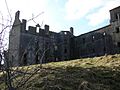
[edit]-
 Garlies Castle.
 -
 Wreaths Tower, Kirkbean.
 -
 Orchardtown Tower, Buittle.
 -
-
 Kenmure Castle, Kells parish.
 -
-
 McLellan's Castle, Kirkcudbright.
 -
 Lochinvar Castle site.
 -
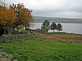
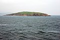 Hestan Island
 -
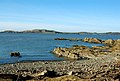 Gypsy Point looking over to Little Ross
 -
 The Motte of Urr
 -
 Remains of Sweetheart Abbey
 -
 Bridge over the Dee at Tongland
 -
 Hillfort near Twynholm


Notable Inhabitants
[edit]- Alan of Galloway, Lord of Galloway and Constable of Scotland
- Archibald the Grim, Lord of Galloway and Earl of Douglas
- Malcolm Caldwell, Marxist writer, chair of the Campaign for Nuclear Disarmament
- James Clerk Maxwell, 19th century physicist
- David Coulthard, Formula 1 Grand Prix winner from Twynholm
- S. R. Crockett, Minister and novelist
- Devorguilla, Mother of John I, king of Scotland
- Sir William Douglas, Founded the town of Castle Douglas
- Campbell Cowan Edgar, Egyptologist and Secretary-General of the Egyptian Museum in Cairo[38]
- E A Hornel, Painter born in Australia
- John Paul Jones, Scots born American and Russian naval commander
- Margaret McNaughton, Scottish Canadian writer
- Alexander Murray, Edinburgh University professor
- John Welsh of Irongray, leader of the Scottish Covenanter Movement
References
[edit]- ^ The New Statistical Account of Scotland (1834)
- ^ Togodumnus (Kevan White). "SHAWHEAD CAMPS". roman-britain.org. Archived from the original on 6 January 2014.
- ^ P. H: M'Kerlie. "Galloway in ancient and modern times pg 62" (PDF).
- ^ Graham-Campbell, James (1978). "The Viking-age silver and gold hoards of Scandinavian character from Scotland". Proceedings of the Society of Antiquaries of Scotland. 107: 114–135. doi:10.9750/PSAS.107.114.135. ISSN 2056-743X. S2CID 52252942.
- ^ "Looting Scotland in the Viking Age | National Museums Scotland Blog". 22 September 2021. Archived from the original on 22 September 2021. Retrieved 22 September 2021.
- ^ Thompson, J D A (1956). Inventory of British Coin Hoards, AD 600-1500. London: Royal Numismatic Society. p. 132.
- ^ a b Learmonth, William (1920). Kirkcudbrightshire and Wigtownshire. Cambridge: Cambridge University Press. p. 1. Retrieved 27 November 2022.
- ^ "Visit Kirkcudbright – Historical Sites". Kirkcudbright.co.uk. Retrieved 20 January 2013.
- ^ "Samuel Rutherford - Fair Anwoth by the Solway - 1627 - 1636". Archived from the original on 27 February 2014. Retrieved 22 February 2014.
- ^ "Welcome to Canmore – Canmore". rcahms.gov.uk.
- ^ Historic Environment Scotland. "County Buildings, 121, 123 High Street, Kirkcudbright (LB36523)". Retrieved 18 July 2021.
- ^ "Local Government (Scotland) Act 1973", legislation.gov.uk, The National Archives, 1973 c. 65, retrieved 22 November 2022
- ^ "Stewartry Area Committee". Dumfries and Galloway Council. Retrieved 2 December 2022.
- ^ "The Lord-Lieutenants (Scotland) Order 1996", legislation.gov.uk, The National Archives, SI 1996/731, retrieved 25 November 2022
- ^ "Kirkcudbrightshire". Encyclopaedia Britannica. Retrieved 31 December 2020.
- ^ "Scotland, Creetown – Quarry at Kirkmabreck". dalbeattie.com.
- ^ a b c d Awdry (1990), page 66
- ^ Map of Parishes in the Counties of Wigtown & Kircudbright, ScotlandsFamily
- ^ stephenclancy (22 May 2012). "The Parishes". Stewartrykirks.org.uk. Retrieved 20 January 2013.
- ^ "The Parish of Colvend". Kirkcudbright.co. Retrieved 20 January 2013.
- ^ "Civil Parish of Girthon map".
- ^ Lewis, Samuel (1851). "A Topographical Dictionary of Scotland". pp. 490–491.
- ^ "Parish of Girthon – History of the Lands and Their Owners in Galloway". Kirkcudbright.co. Retrieved 20 January 2013.
- ^ "Parish of Kells Map". Scottish-places.info. Retrieved 20 January 2013.
- ^ Chalmers, George (1824). "Parish of Kelton". Caledonia. p. 314.
- ^ "The Parish of Kelton". Kirkcudbright.co. Retrieved 20 January 2013.
- ^ Lewis, Samuel (1851). "A Topographical Dictionary of Scotland". pp. 106–107.
- ^ "The Parish of Kirkgunzeon". Kirkcudbright.co. Retrieved 20 January 2013.
- ^ Lewis, Samuel (1851). "A Topographical Dictionary of Scotland". pp. 112–113.
- ^ "The Parish of Kirkmabreck". Kirkcudbright.co. Retrieved 20 January 2013.
- ^ "Irongray". Scotlands Places. Archived from the original on 9 November 2012. Retrieved 16 April 2013. "Archived copy". Archived from the original on 9 November 2012. Retrieved 16 April 2013.
{{cite web}}: CS1 maint: archived copy as title (link) CS1 maint: bot: original URL status unknown (link) - ^ Lewis, Samuel (1851). "A Topographical Dictionary of Scotland". p. 125.
- ^ "Statistical Account". 1792.
- ^ Lewis, Samuel (1851). "A Topographical Dictionary of Scotland". pp. 200–201.
- ^ "The Parish of Lochrutton". Kirkcudbright.co. Retrieved 20 January 2013.
- ^ Lewis, Samuel (1851). "A Topographical Dictionary of Scotland". pp. 415–416.
- ^ "The Parish of Rerrick". Kirkyards.co.uk. Retrieved 20 January 2013.
- ^ "Campbell Cowan Edgar, Department Of Antiquities". Dalrymple Crescent Families. Retrieved 19 April 2021.
Further reading
[edit]- Sir Herbert Maxwell, History of Dumfries and Galloway (Edinburgh, 1896)
- Rev. Andrew Symson, A Large Description of Galloway (1684; new ed., 1823) A large description of Galloway [ed. by T. Maitland.]
- Thomas Murray, The Literary History of Galloway (1822)
- Rev. William Mackenzie, History of Galloway (1841)
- P. H. McKerlie, History of the Lands and their Owners in Galloway (Edinburgh, 1870–1879)
- Galloway Ancient and Modern (Edinburgh, 1891)
- J. A. H. Murray, Dialect of the Southern Counties of Scotland (London, 1873).
External links
[edit]This article incorporates text from a publication now in the public domain: Chisholm, Hugh, ed. (1911). "Kirkcudbrightshire". Encyclopædia Britannica (11th ed.). Cambridge University Press.
| International | |
|---|---|
| National | |