
Kappil, Thiruvananthapuram: Difference between revisions
Content deleted Content added
Alanwiki256 (talk | contribs) No edit summary Tag: Reverted |
m Undid revision 1226385911 by Hobbywriterae (talk) Rm Indic script as WP:NOINDICSCRIPT |
||
| (13 intermediate revisions by 11 users not shown) | |||
| Line 4: | Line 4: | ||
{{More citations needed|date=May 2012}} |
{{More citations needed|date=May 2012}} |
||
{{Infobox settlement |
{{Infobox settlement |
||
| name = Kappil |
| name = Kappil |
||
| other_name = |
| other_name = |
||
| nickname = |
| nickname = |
||
| settlement_type = place |
| settlement_type = place |
||
| image_skyline = |
| image_skyline = |
||
| image_alt = Kappil - Varkala Coastal Road |
| image_alt = Kappil - Varkala Coastal Road |
||
| image_caption = Kappil Road |
| image_caption = Kappil Road |
||
| pushpin_map = India Kerala#India |
| pushpin_map = India Kerala#India |
||
| pushpin_label_position = right |
| pushpin_label_position = right |
||
| pushpin_map_alt = |
| pushpin_map_alt = |
||
| pushpin_map_caption = Location in Kerala, India |
| pushpin_map_caption = Location in Kerala, India |
||
| coordinates = {{coord|8|46|49|N|76|40|35|E|display=inline,title}} |
| coordinates = {{coord|8|46|49|N|76|40|35|E|display=inline,title}} |
||
| subdivision_type = Country |
| subdivision_type = Country |
||
| subdivision_name = {{flag|India}} |
| subdivision_name = {{flag|India}} |
||
| subdivision_type1 = [[States and territories of India|State]] |
| subdivision_type1 = [[States and territories of India|State]] |
||
| subdivision_name1 = [[Kerala]] |
| subdivision_name1 = [[Kerala]] |
||
| subdivision_type2 = [[List of districts of India|District]] |
| subdivision_type2 = [[List of districts of India|District]] |
||
| subdivision_name2 = [[Thiruvananthapuram]] |
| subdivision_name2 = [[Thiruvananthapuram]] |
||
| established_title = <!-- Established --> |
| established_title = <!-- Established --> |
||
| established_date = |
| established_date = |
||
| founder = |
| founder = |
||
| named_for = |
| named_for = |
||
| government_type = |
| government_type = |
||
| governing_body = Edava Panchayat |
| governing_body = Edava Panchayat |
||
| unit_pref = Metric |
| unit_pref = Metric |
||
| area_footnotes = |
| area_footnotes = |
||
| area_rank = |
| area_rank = |
||
| area_total_km2 = 3 |
| area_total_km2 = 3 |
||
| elevation_footnotes = |
| elevation_footnotes = |
||
| elevation_m = |
| elevation_m = |
||
| population_total = |
| population_total = |
||
| population_as_of = |
| population_as_of = |
||
| population_rank = |
| population_rank = |
||
| population_density_km2 = auto |
| population_density_km2 = auto |
||
| population_demonym = |
| population_demonym = |
||
| population_footnotes = |
| population_footnotes = |
||
| demographics_type1 = Languages |
| demographics_type1 = Languages |
||
| demographics1_title1 = Official |
| demographics1_title1 = Official |
||
| demographics1_info1 = [[Malayalam language|Malayalam]] |
| demographics1_info1 = [[Malayalam language|Malayalam]] |
||
| timezone1 = [[Indian Standard Time|IST]] |
| timezone1 = [[Indian Standard Time|IST]] |
||
| utc_offset1 = +5:30 |
| utc_offset1 = +5:30 |
||
| postal_code_type = [[Postal Index Number|PIN]] |
| postal_code_type = [[Postal Index Number|PIN]] |
||
| postal_code = 695311<ref>{{Cite web|url=http://www.mapsofindia.com/pincode/india/kerala/thiruvananthapuram/kappil.html|title=Pin Code of Kappil in Thiruvananthapuram, Kerala|access-date=2018-10-24|website=mapsofindia.com}}</ref> |
| postal_code = 695311<ref>{{Cite web|url=http://www.mapsofindia.com/pincode/india/kerala/thiruvananthapuram/kappil.html|title=Pin Code of Kappil in Thiruvananthapuram, Kerala|access-date=2018-10-24|website=mapsofindia.com}}</ref> |
||
| area_code_type = Telephone code |
|||
| |
| area_code = 0471 |
||
| registration_plate = KL 81<ref>{{Cite web|url=https://mvd.kerala.gov.in/en/node/825}}</ref> |
|||
| area_code = 0470 |
|||
| |
| blank1_name_sec1 = Nearest city |
||
| |
| blank1_info_sec1 = [[Thiruvananthapuram]] |
||
| |
| blank2_name_sec1 = [[Niyamasabha]] constituency |
||
| |
| blank2_info_sec1 = [[Chathannor]] |
||
| |
| website = https://trivandrum.nic.in/en/ |
||
| |
| footnotes = |
||
| footnotes = |
|||
}} |
}} |
||
'''Kappil''' is a tourist spot in |
'''Kappil''' is a seashore tourist spot located in Thiruvananthapuram district, [[Kerala]], [[India]]. [[Paravur railway station|Varkala railway station]] is the major railway station near Kappil.<ref>{{Cite web|url=https://www.keralatourism.org/destination/kappil-beach-backwaters-Paravoor/427|title=Kappil beach and backwaters|access-date=2018-10-24|website=keralatourism.org|publisher=Kerala Tourism Department}}</ref> |
||
==Transportation== |
==Transportation== |
||
===Road=== |
===Road=== |
||
Kappil lies on the [[Varkala]] - [[Paravur, Kollam|Paravur]] - |
Kappil lies on the [[Varkala]] - [[Paravur, Kollam|Paravur]] - Kollam Road. |
||
===Rail=== |
===Rail=== |
||
| Line 70: | Line 69: | ||
*[[Kappil railway station]] |
*[[Kappil railway station]] |
||
*[[Edavai railway station]] |
*[[Edavai railway station|Edava railway station]] |
||
===Air=== |
===Air=== |
||
[[Trivandrum International Airport]], located |
[[Trivandrum International Airport]], located 46 km away. |
||
==Tourism== |
==Tourism== |
||
| Line 80: | Line 79: | ||
Scenic backwaters, beach and facilities for watersport are available. |
Scenic backwaters, beach and facilities for watersport are available. |
||
Kappil is also famous for |
Kappil is also famous for the Kappil Bhagavathy Temple and is a tourist spot during the festival season. |
||
==Nearby Places== |
==Nearby Places== |
||
* Varkala Beach |
* [[Varkala Beach]] |
||
* Odayam Beach |
* Odayam Beach |
||
* Manthra Beach |
* Manthra Beach |
||
* Sivagiri Mutt |
* [[Sivagiri, Kerala|Sivagiri Mutt]] |
||
* Varkala Black Beach |
* Varkala Black Beach |
||
* Janardhanaswami Temple |
* [[Janardanaswamy Temple|Janardhanaswami Temple]] |
||
* Kappil Devi Temple |
* Kappil Devi Temple |
||
Latest revision as of 10:06, 30 May 2024
This article needs additional citations for verification. (May 2012) |
Kappil | |
|---|---|
place | |
 Kappil Location in Kerala, India  Kappil Kappil (India) | |
| Coordinates: 8°46′49″N 76°40′35″E / 8.78028°N 76.67639°E | |
| Country | |
| State | Kerala |
| District | Thiruvananthapuram |
| Government | |
| • Body | Edava Panchayat |
| Area | |
| • Total | 3 km2 (1 sq mi) |
| Languages | |
| • Official | Malayalam |
| Time zone | UTC+5:30 (IST) |
| PIN | 695311[1] |
| Telephone code | 0471 |
| Vehicle registration | KL 81[2] |
| Nearest city | Thiruvananthapuram |
| Niyamasabha constituency | Chathannor |
| Website | https://trivandrum.nic.in/en/ |
Kappil is a seashore tourist spot located in Thiruvananthapuram district, Kerala, India. Varkala railway station is the major railway station near Kappil.[3]
Transportation[edit]
Road[edit]
Kappil lies on the Varkala - Paravur - Kollam Road.
Rail[edit]
- Varkala Railway Station, which is 7 km (4.3 mi) from Kappil, is well connected to major cities such as Kollam, Trivandrum, Delhi and Chennai.
Air[edit]
Trivandrum International Airport, located 46 km away.
Tourism[edit]


Scenic backwaters, beach and facilities for watersport are available.
Kappil is also famous for the Kappil Bhagavathy Temple and is a tourist spot during the festival season.
Nearby Places[edit]
- Varkala Beach
- Odayam Beach
- Manthra Beach
- Sivagiri Mutt
- Varkala Black Beach
- Janardhanaswami Temple
- Kappil Devi Temple
Gallery[edit]
-
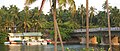 Kappil boatclub
 -
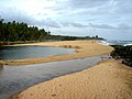 View of the beach
 -
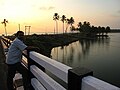 An evening view from Kappil Bridge
 -
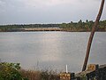 Edava-Nadayara Lake and Kappil Railway Bridge
 -
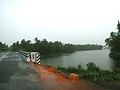 A rainy day
 -
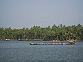 Thekkumbhagam boat race
 -
 Kappil Beach


.jpg)

References[edit]
- ^ "Pin Code of Kappil in Thiruvananthapuram, Kerala". mapsofindia.com. Retrieved 24 October 2018.
- ^ https://mvd.kerala.gov.in/en/node/825.
{{cite web}}: Missing or empty|title=(help) - ^ "Kappil beach and backwaters". keralatourism.org. Kerala Tourism Department. Retrieved 24 October 2018.
External links[edit]
 Media related to Kappil, Thiruvananthapuram at Wikimedia Commons
| City corporations |  | |
|---|---|---|
| Municipalities | ||
| Revenue divisional office | ||
| Talukas and villages | ||
This article related to a location in Kollam district, Kerala, India is a stub. You can help Wikipedia by expanding it. |