
Al Buraimi Governorate: Difference between revisions
Quatchenerlo (talk | contribs) Reduced whitespace by moving picture |
corrected governor and added citation |
||
| (18 intermediate revisions by 4 users not shown) | |||
| Line 1: | Line 1: | ||
{{short description|Governorate of Oman}} |
{{short description|Governorate of Oman}} |
||
{{Use dmy dates|date=May 2020}} |
{{Use dmy dates|date=May 2020}} |
||
{{Infobox settlement |
{{Infobox settlement |
||
<!--See the Table at Infobox Settlement for all fields and descriptions of usage--> |
<!--See the Table at Infobox Settlement for all fields and descriptions of usage--> |
||
<!-- Basic info ----------------> |
<!-- Basic info ----------------> |
||
|official_name = Al Buraimi Governorate |
| official_name = Al Buraimi Governorate |
||
|other_name = |
| other_name = |
||
|native_name = {{lang|ar|مُحَافَظَة ٱلْبُرَيْمِي}} |
| native_name = {{transliteration|ar|Muḥāfaẓat Al-Buraimī}} ({{lang|ar|مُحَافَظَة ٱلْبُرَيْمِي}}) |
||
|native_name_lang = ar |
| native_name_lang = ar |
||
|nickname = |
| nickname = |
||
|settlement_type = <!--For Town or Village (Leave blank for the default City)--> |
| settlement_type = <!--For Town or Village (Leave blank for the default City)--> |
||
|motto = |
| motto = |
||
<!-- images and maps -----------> |
<!-- images and maps -----------> |
||
|image_skyline = Al_Ain_-_Buraimi_border.JPG |
| image_skyline = Al_Ain_-_Buraimi_border.JPG |
||
| |
| image_size = 300px |
||
|image_caption = Border control with [[Al-Ain]] as of late 2006 |
| image_caption = Border control with [[Al-Ain]] as of late 2006 |
||
|image_flag = |
| image_flag = |
||
|flag_size = |
| flag_size = |
||
|image_seal = |
| image_seal = |
||
|seal_size = |
| seal_size = |
||
|image_shield = |
| image_shield = |
||
|shield_size = |
| shield_size = |
||
|image_blank_emblem = |
| image_blank_emblem = |
||
|blank_emblem_type = |
| blank_emblem_type = |
||
|blank_emblem_size = |
| blank_emblem_size = |
||
|image_map = Al Buraymi in Oman 2016.svg |
| image_map = Al Buraymi in Oman 2016.svg |
||
| |
| map_size = |
||
|map_caption = |
| map_caption = |
||
|image_map1 = |
| image_map1 = |
||
| |
| map_size1 = |
||
|map_caption1 = |
| map_caption1 = |
||
|image_dot_map = |
| image_dot_map = |
||
|dot_mapsize = |
| dot_mapsize = |
||
|dot_map_caption = |
| dot_map_caption = |
||
|dot_x = |
| dot_x = |dot_y = |
||
|pushpin_map = |
| pushpin_map = |
||
|pushpin_label_position = |
| pushpin_label_position = |
||
|pushpin_mapsize = |
| pushpin_mapsize = |
||
|pushpin_map_caption = |
| pushpin_map_caption = |
||
| pushpin_relief = |
|||
|subdivision_type = [[List of sovereign states|Country]] |
| subdivision_type = [[List of sovereign states|Country]] |
||
| subdivision_name = {{OMN}} |
|||
| |
| subdivision_name = {{OMN}} |
||
| |
| subdivision_type1 = |
||
| |
| subdivision_name1 = |
||
| |
| subdivision_type2 = |
||
| |
| subdivision_name2 = |
||
| |
| subdivision_type3 = |
||
| |
| subdivision_name3 = |
||
| |
| subdivision_type4 = |
||
| subdivision_name4 = |
|||
<!-- Politics -----------------> |
<!-- Politics -----------------> |
||
|government_footnotes = |
| government_footnotes = |
||
|government_type = |
| government_type = |
||
| seat_type = [[Capital (political)|Capital]] |
| seat_type = [[Capital (political)|Capital]] |
||
| seat = [[Al-Buraimi]] |
| seat = [[Al-Buraimi]] |
||
|leader_title = Governor |
| leader_title = Governor |
||
|leader_name = Dr. Hamad bin Ahmed bin Saud Al Busaidi |
| leader_name = Dr. Hamad bin Ahmed bin Saud Al Busaidi |
||
|leader_title1 = <!-- for places with, say, both a mayor and a city manager --> |
| leader_title1 = <!-- for places with, say, both a mayor and a city manager --> |
||
|leader_name1 = |
| leader_name1 = |
||
|leader_title2 = |
| leader_title2 = |
||
|leader_name2 = |
| leader_name2 = |
||
|leader_title3 = |
| leader_title3 = |
||
|leader_name3 = |
| leader_name3 = |
||
|leader_title4 = |
| leader_title4 = |
||
|leader_name4 = |
| leader_name4 = |
||
|established_title = <!-- Settled --> |
| established_title = <!-- Settled --> |
||
|established_date = |
| established_date = |
||
|established_title2 = <!-- Incorporated (town) --> |
| established_title2 = <!-- Incorporated (town) --> |
||
|established_date2 = |
| established_date2 = |
||
|established_title3 = <!-- Incorporated (city) --> |
| established_title3 = <!-- Incorporated (city) --> |
||
|established_date3 = |
| established_date3 = |
||
<!-- Area ---------------------> |
<!-- Area ---------------------> |
||
|area_magnitude = |
| area_magnitude = |
||
|unit_pref = <!--Enter: Imperial, if Imperial (metric) is desired--> |
| unit_pref = <!--Enter: Imperial, if Imperial (metric) is desired--> |
||
|area_footnotes = |
| area_footnotes = |
||
|area_total_km2 = |
| area_total_km2 = |
||
|area_land_km2 = |
| area_land_km2 = 7,000 |
||
|area_water_km2 = |
| area_water_km2 = |
||
|area_total_sq_mi = |
| area_total_sq_mi = |
||
|area_land_sq_mi = |
| area_land_sq_mi = |
||
|area_water_sq_mi = |
| area_water_sq_mi = |
||
|area_water_percent = |
| area_water_percent = |
||
|area_urban_km2 = |
| area_urban_km2 = |
||
|area_urban_sq_mi = |
| area_urban_sq_mi = |
||
|area_metro_km2 = |
| area_metro_km2 = |
||
|area_metro_sq_mi = |
| area_metro_sq_mi = |
||
|area_blank1_title = |
| area_blank1_title = |
||
|area_blank1_km2 = |
| area_blank1_km2 = |
||
|area_blank1_sq_mi = |
| area_blank1_sq_mi = |
||
<!-- Population -----------------------> |
<!-- Population -----------------------> |
||
|population_as_of = December 2020 |
| population_as_of = December 2020 |
||
| population_footnotes = <ref>{{cite web|url=https://data.gov.om/OMPOP2016/population|title=Population - DATA PORTAL|publisher=National Centre for Statistics & Information|access-date=2021-10-15}}</ref> |
| population_footnotes = <ref>{{cite web |url=https://data.gov.om/OMPOP2016/population |title=Population - DATA PORTAL |publisher=National Centre for Statistics & Information |access-date=2021-10-15}}</ref> |
||
|population_note = |
| population_note = |
||
|population_total = 121,802 |
| population_total = 121,802 |
||
|population_density_km2 = |
| population_density_km2 = |
||
|population_density_sq_mi = |
| population_density_sq_mi = |
||
|population_metro = |
| population_metro = |
||
|population_density_metro_km2 = |
| population_density_metro_km2 = |
||
|population_density_metro_sq_mi = |
| population_density_metro_sq_mi = |
||
|population_urban = |
| population_urban = |
||
|population_density_urban_km2 = |
| population_density_urban_km2 = |
||
|population_density_urban_sq_mi = |
| population_density_urban_sq_mi = |
||
|population_blank1_title = Ethnicities |
| population_blank1_title = Ethnicities |
||
|population_blank1 = |
| population_blank1 = |
||
|population_blank2_title = Religions |
| population_blank2_title = Religions |
||
|population_blank2 = |
| population_blank2 = |
||
|population_density_blank1_km2 = |
| population_density_blank1_km2 = |
||
|population_density_blank1_sq_mi = |
| population_density_blank1_sq_mi = |
||
<!-- General information ---------------> |
<!-- General information ---------------> |
||
|timezone = |
| timezone = |
||
|utc_offset = |
| utc_offset = |
||
|timezone_DST = |
| timezone_DST = |
||
|utc_offset_DST = |
| utc_offset_DST = |
||
|coordinates = {{coord|24|15|N|55|47|E|region:OM|display=inline,title}} |
| coordinates = {{coord|24|15|N|55|47|E|region:OM|display=inline,title}} |
||
|elevation_footnotes = <!--for references: use <ref> </ref> tags--> |
| elevation_footnotes = <!--for references: use <ref> </ref> tags--> |
||
|elevation_m = |
| elevation_m = |
||
|elevation_ft = <!-- accord. to Google Earth--> |
| elevation_ft = <!-- accord. to Google Earth--> |
||
<!-- Area/postal codes & others --------> |
<!-- Area/postal codes & others --------> |
||
|postal_code_type = <!-- enter ZIP code, Postcode, Post code, Postal code... --> |
| postal_code_type = <!-- enter ZIP code, Postcode, Post code, Postal code... --> |
||
|postal_code = |
| postal_code = |
||
|area_code = |
| area_code = |
||
|blank_name = |
| blank_name = |
||
|blank_info = |
| blank_info = |
||
|blank1_name = |
| blank1_name = |
||
|blank1_info = |
| blank1_info = |
||
|website = |
| website = |
||
|footnotes = |
| footnotes = |
||
}} |
}} |
||
'''Al Buraimi Governorate''' ({{lang-ar|مُحَافَظَة ٱلْبُرَيْمِي|Muḥāfaẓat Al-Buraimī}}) is one of the 11 [[Governorates of Oman|governorates]] of [[Oman]]. |
'''Al Buraimi Governorate''' ({{lang-ar|مُحَافَظَة ٱلْبُرَيْمِي|Muḥāfaẓat Al-Buraimī}}) is one of the 11 [[Governorates of Oman|governorates]] of [[Oman]]. The area was part of [[Ad Dhahirah Region]] until October 2006, when a new governorate was created from the [[Wilayah|Wilayat]]s ([[Provinces of Oman|Provinces]]) of Al Buraymi and [[Mahdah]]. A third wilayat, As-[[Sunaynah]], was created from parts of the two. Dr. Hamad bin Ahmed Al Busaidi has been governor since 2020.<ref>{{cite web |title=His Majesty appoints new ministers |url=https://www.omanobserver.om/article/11305/Main/his-majesty-appoints-new-ministers |website=Oman Daily Observer |date=19 August 2020}}</ref> |
||
The town of [[Al-Buraimi]] is an oasis town in northwestern Oman, on the border of the [[United Arab Emirates]]. [[Al Ain]] is an adjacent city on the UAE side of the border. Both settlements are part of the [[Tawam (region)|historical region of Tawam]]<ref name="Al-Hosani2012">{{cite thesis |last=Al-Hosani |first=Hamad Ali |title=The Political Thought of Zayed bin Sultan Al Nahyan |publisher=[[Durham University]] |pages=43–44 |url=http://etheses.dur.ac.uk/3448/1/electronic_version_of_my_thesis.pdf |format=PhD Thesis |url-status=live |archive-url=https://web.archive.org/web/20170205164804/http://www.na.ae/en/Images/LIWA12.pdf |year=2012 |access-date=15 April 2016 |archive-date=5 February 2017}}</ref> or Al-Buraimi [[Oasis]].<ref name="ENA 12-2014">{{cite book |editor-last=El Reyes |editor-first=Dr. Abdulla |title=Liwa Journal of the National Archives |publisher=Emirati National Archives |pages=35–37 |location=United Arab Emirates |url=http://www.na.ae/en/Images/LIWA12.pdf |date=December 2014 |access-date=5 February 2017 |language=en |archive-date=6 February 2017 |archive-url=https://web.archive.org/web/20170206103840/http://www.na.ae/en/Images/LIWA12.pdf }}</ref> For many decades, there had been an open border between Al-Buraimi located in Oman and Al-Ain. In September 2006, this border was relocated to an area near [[Hili Archaeological Park|Hilli]] which is around {{convert|8|km|mile|abbr=off}} from the traditional open border. The traditional border near Al-Ain City is now closed to all except to those with valid visas ([[Cooperation Council for the Arab States of the Gulf|GCC]] nationals require no visa).{{ |
The town of [[Al-Buraimi]] is an oasis town in northwestern Oman, on the border of the [[United Arab Emirates]]. [[Al Ain]] is an adjacent city on the UAE side of the border. Both settlements are part of the [[Tawam (region)|historical region of Tawam]]<ref name="Al-Hosani2012">{{cite thesis |last=Al-Hosani |first=Hamad Ali |title=The Political Thought of Zayed bin Sultan Al Nahyan |publisher=[[Durham University]] |pages=43–44 |url=http://etheses.dur.ac.uk/3448/1/electronic_version_of_my_thesis.pdf |format=PhD Thesis |url-status=live |archive-url=https://web.archive.org/web/20170205164804/http://www.na.ae/en/Images/LIWA12.pdf |year=2012 |access-date=15 April 2016 |archive-date=5 February 2017}}</ref> or Al-Buraimi [[Oasis]].<ref name="ENA 12-2014">{{cite book |editor-last=El Reyes |editor-first=Dr. Abdulla |title=Liwa Journal of the National Archives |publisher=Emirati National Archives |pages=35–37 |location=United Arab Emirates |url=http://www.na.ae/en/Images/LIWA12.pdf |date=December 2014 |access-date=5 February 2017 |language=en |archive-date=6 February 2017 |archive-url=https://web.archive.org/web/20170206103840/http://www.na.ae/en/Images/LIWA12.pdf }}</ref> For many decades, there had been an open border between Al-Buraimi located in Oman and Al-Ain. In September 2006, this border was relocated to an area near [[Hili Archaeological Park|Hilli]] which is around {{convert|8|km|mile|abbr=off}} from the traditional open border. The traditional border near Al-Ain City is now closed to all except to those with valid visas ([[Cooperation Council for the Arab States of the Gulf|GCC]] nationals require no visa).<ref name="World66 09-2007">{{cite web |last=Law |first=Andy |title=Buraimi Travel Guide |website=World 66|url=http://www.world66.com/asia/middleeast/oman/buraimi |archive-url=https://web.archive.org/web/20070927190930/http://www.world66.com/asia/middleeast/oman/buraimi |date=2006-09-20 |archive-date=2007-09-27 |access-date=2007-10-15}}</ref> |
||
==Climate== |
==Climate== |
||
Al Buraimi has a [[hot desert climate]] ([[Köppen climate classification]]: ''BWh''). |
Al Buraimi has a [[hot desert climate]] ([[Köppen climate classification]]: ''BWh''). Daily high temperatures average over 40 degrees Celsius (104 degrees Fahrenheit) from May through September. |
||
{{Weather box |
{{Weather box |
||
|width = auto |
|width = auto |
||
| Line 198: | Line 201: | ||
{{Historical populations |
{{Historical populations |
||
|title = |
|title = |
||
|align = |
|align = right |
||
|clear = |
|clear = |
||
|direction = |
|direction = |
||
| Line 224: | Line 227: | ||
|2020 |121,802 |
|2020 |121,802 |
||
}} |
}} |
||
As of 2020, Al Buraimi Governorate had a population of 121,802, more than doubling in size since 1993. It is the third-least-populous of Oman's 11 governorates, after [[Musandam Governorate|Musandam]] and [[Al Wusta Governorate (Oman)|Al Wusta]]. The city of [[Al-Buraimi]], with 92,223 inhabitants, comprises the vast majority of the governorate's population. |
|||
{{clear}} |
{{clear}} |
||
| ⚫ | |||
Transport in and around Al-Buraimi is by taxis, which like the majority of taxis in Oman are coloured orange and white. Drivers accept payment in both Omani Riyals and United Arab Emirates Dirhams, a trip within the township of Al-Buraimi will generally cost no more than 5 AED/0.5 OMR to 1.5 OMR. A trip to [[Mahdha]] may cost over 50 AED / 5 to 10 OMR.{{citation needed|date=January 2019}} |
|||
==Infrastructure== |
|||
| ⚫ | Buraimi lies on a bus route from [[Dubai]] to [[Muscat]].<ref name="KhaleejTimes 01-2019">{{cite news |last=Tesorero |first=Angel |title=Dubai-Muscat bus trip to be linked to 3 Metro stations |newspaper=[[Khaleej Times]] |location=Dubai |url=https://www.khaleejtimes.com/news/transport/Dubai-Muscat-bus-trip-to-be-linked-to-3-Metro-stations |date=2019-01-29 |access-date=2019-01-30}}</ref> |
||
| ⚫ | |||
==Culture== |
|||
| ⚫ | Transportation in and around Al-Buraimi mainly occurs using private cars and taxis. Buraimi also lies on a bus route from [[Dubai]] to [[Muscat]].<ref name="KhaleejTimes 01-2019">{{cite news |last=Tesorero |first=Angel |title=Dubai-Muscat bus trip to be linked to 3 Metro stations |newspaper=[[Khaleej Times]] |location=Dubai |url=https://www.khaleejtimes.com/news/transport/Dubai-Muscat-bus-trip-to-be-linked-to-3-Metro-stations |date=2019-01-29 |access-date=2019-01-30}}</ref> |
||
{{See also|List of mosques in Oman}} |
|||
===Landmarks=== |
|||
Al-Buraimi, like the rest of Oman, features many historic forts in varying condition. The largest mosque in Al-Buraimi is the Sultan Qaboos Grand Mosque, named after the [[Sultan of Oman|Sultan]], [[Qaboos bin Said al Said]].<ref name="MuscatDaily 06-2014">{{cite news |newspaper=The [[Muscat Daily]] |title=Oman Tourism: Exploring Buraim |location=[[Muscat]] |url=https://timesofoman.com/article/75014 |date=2016-01-06 |access-date=2019-01-20}}</ref><ref name="TOO 01-2016">{{cite news |last=Aymerich |first=Olga |title=Oman Tourism: Exploring Buraim |newspaper=The [[Times of Oman]] |url=https://timesofoman.com/article/75014 |date=2016-01-06 |access-date=2019-01-20}}</ref> There are ruins of ancient hovels and a fort in Al-Buraimi.{{citation needed|date=January 2019}} |
|||
Al-Buraimi, like the rest of Oman, features many historic forts in varying condition. The largest mosque in Al-Buraimi is the [[Sultan Qaboos Grand Mosque, Al-Buraimi|Sultan Qaboos Grand Mosque]], named after the former [[Sultan of Oman|Sultan]], [[Qaboos bin Said al Said]].<ref name="AGU 05-2013">{{citation |last=Jordan |first=Benjamin R. |title=Geotrekking in Southeastern Arabia: A Guide to Locations of World-Class Geology |publisher=[[American Geophysical Union]], [[Wiley (publisher)|Wiley]] |chapter=Route 4: Jebel Huwayya (Fossil Valley), Oman |pages=38–40 |isbn=978-1-1186-7128-3 |location=[[Washington, D.C.]], the [[United States|U.S.A.]] |doi=10.1029/SP065 |url=https://www.google.com/books/edition/Geotrekking_in_Southeastern_Arabia/LQToK4NBHLkC |date=2013-05-09 |access-date=2024-03-08}}</ref><ref name="SQ">{{cite web |website=Sultan Qaboos |title=جوامع السلطان قابوس |language=ar |url=https://sultanqaboos.net/achievements/%D8%AC%D9%88%D8%A7%D9%85%D8%B9-%D8%A7%D9%84%D8%B3%D9%84%D8%B7%D8%A7%D9%86-%D9%82%D8%A7%D8%A8%D9%88%D8%B3/ |access-date=2024-03-08}}</ref> There are ruins of ancient hovels and a fort in Al-Buraimi.<ref name="TOO 01-2016">{{cite news |last=Aymerich |first=Olga |title=Oman Tourism: Exploring Buraimi |newspaper=The [[Times of Oman]] |url=https://timesofoman.com/article/394-oman-tourism-exploring-buraimi |date=2016-01-06 |access-date=2019-01-20}}</ref><ref name="AT_Buraimi">{{cite web |website=Arab Travelers |title=Top 8 places of tourism in Buraimi, Sultanate of Oman |url=https://en.arabtravelers.com/top-8-places-of-tourism-in-buraimi-sultanate-of-oman/ |access-date=2024-03-07}}</ref><ref name="DO_Buraimi">{{cite web |website=Destination Oman |title=Al Buraimi |url=https://www.destinationoman.com/al-buraimi/24 |access-date=2024-03-07}}</ref> |
|||
<gallery> |
|||
File:Mezyad Fort.jpg|[[Jebel Hafeet]], which the governorate shares with the [[United Arab Emirates|U.A.E.]], as viewed from [[Mezyad Fort]] in the adjacent Emirati city of [[Al Ain]] |
|||
File:جامع السلطان قابوس في البريمي.jpg|The [[Sultan Qaboos Grand Mosque, Al-Buraimi|Grand Mosque]] |
|||
</gallery> |
|||
==History and prehistory== |
==History and prehistory== |
||
{{see also|List of oldest continuously inhabited cities}} |
{{see also|List of oldest continuously inhabited cities}} |
||
Being in the region of the Western Hajar,<ref name="DumperStanley2007">{{cite encyclopedia | |
Being in the region of the Western Hajar,<ref name="DumperStanley2007">{{cite encyclopedia |year=2007 |title=Buraimi and Al-Ain |encyclopedia=Cities of the Middle East and North Africa: A Historical Encyclopedia |publisher=[[ABC-CLIO]] |url=https://books.google.com/books?id=3SapTk5iGDkC&q=buraimi+al-ain |last=Abu-Lughod |first=Janet L. |editor-last=Dumper |editor-first=Michael R. T. |pages=99–100 |isbn=978-1-5760-7919-5 |editor-last2=Stanley |editor-first2=Bruce E.}}</ref><ref name="Allen2016">{{cite book |last=Allen |first=Calvin H. Jr. |title=Oman: the Modernization of the Sultanate |publisher=[[Routledge]] |chapter=1: Land and People |pages=1–8 |isbn=978-1-3172-9164-0 |location=Abingdon, [[New York City|New York]] |chapter-url=https://books.google.com/books?id=tlmFCwAAQBAJ&pg=PA1 |date=2016-02-05}}</ref> the area of Al-Buraimi and Al-Ain, traditionally referred to as '[[Tawam (region)|Tawam]]', is of historical and cultural importance.<ref name="GulfNews 12-2011">{{Cite news |last=Salama |first=Samir |title=Al Ain bears evidence of a culture's ability to adapt |work=[[Gulf News]] |url=https://gulfnews.com/news/uae/culture/al-ain-bears-evidence-of-a-culture-s-ability-to-adapt-1.958876 |date=2011-12-30 |access-date=2018-08-07}}</ref><ref name="TheNational 10-2015">{{cite news |last=Leech |first=Nick |title=The long read: has a lost Arab capital been found on the Oman-UAE border? |newspaper=[[The National (Abu Dhabi)|The National]] |url=https://www.thenational.ae/arts-culture/the-long-read-has-a-lost-arab-capital-been-found-on-the-oman-uae-border-1.4941 |date=2015-10-22 |access-date=2019-01-20}}</ref> It is demonstrated to have been inhabited as far back as the [[Hafit period]] of the early [[Bronze Age]],<ref name="Potts_al2003">{{Cite book |last1=Potts |first1=Daniel T. |last2=Nābūdah |first2=Ḥasan Muḥammad |last3=Hellyer |first3=Peter |title=Archaeology of the United Arab Emirates |publisher=[[Trident Press]] |pages=174–177 |location=London |oclc=54405078 |isbn=1-9007-2488-X |year=2003}}</ref> and according to one author, an oasis in this region and [[Al-Ahsa Oasis|Al-Hasa]] in [[Saudi Arabia]] are the most important in the [[Arabian Peninsula]].<ref name="Cavendish2007">{{cite book |last1=Cavendish |first1=Marshall |author-link=Marshall Cavendish |title=World and Its Peoples |volume=1 |chapter=Geography and climate |publisher=Cavendish Square Publishing |isbn=978-0-7614-7571-2 |pages=8–19 |url=https://books.google.com/books?id=j894miuOqc4C&q=the+most+important+oases+al-hasa+al+ayn |year=2007}}</ref> |
||
Al-Buraimi was part of Oman from early historical times. From around 600 [[Common Era|CE]], the [[Azd]]i tribes of Oman occupied the area. Then Al-Buraimi town was abandoned in the 700s. The area witnessed events relevant to the [[history of Islam]] during the [[Rashidun Caliphate|Rashidun]], [[Umayyad Caliphate|Umayyad]] and [[Abbasid Caliphate|Abbasid]] eras.<ref name="AbedHellyer2001">{{cite book |last1=Abed |first1=Ibrahim |last2=Hellyer |first2=Peter |title=The United Arab Emirates, A New Perspective |location=London |publisher=[[Trident Press]] Ltd. |year=2001 |pages=60–86 |url=https://books.google.com/books?id=QcMz3zV0qAMC&q=dibba+tuwwam |isbn=978-1-900724-47-0}}</ref> The area had come under the rule of the [[Wajihids|Wajihid Dynasty]] in the 9th century [[Common Era|CE]].<ref name="TheNational 10-2015"/> Al Nuaimi tribe, the original people of the town, rebuilt and ruled it in the 1800s to the 1950s. It had only two rulers, Sheikh Sulṭan bin Mohamed bin Ali Al-Hamood Al Qurtasi Al Naimi, then Sheikh Saqer bin Sulṭan bin Moḥammed Al Hamood Al Qurtasi Al Naimi. The late president of the United Arab Emirates, Sheikh [[Zayed bin Sultan Al Nahyan]], was known to have been brought from [[Abu Dhabi]] to Al-Ain by his mother, [[Salama bint Butti|Shaikhah Salaamah]], following the assassination of his father [[Sultan bin Zayed bin Khalifa Al Nahyan|Sultan bin Zayed]] in 1927.<ref name="Al-Hosani2012"/><ref name="ENA 12-2014"/><ref name="Killgore 03-2005">{{cite journal |last=Killgore |first=Andrew I. |title=Sheikh Zayed bin Sultan Al Nahyan (1918–2004) |journal=[[Washington Report on Middle East Affairs]] |page=41 |url=http://www.wrmea.org/wrmea-archives/272-washington-report-archives-2000-2005/march-2005/8590-in-memoriam-sheikh-zayed-bin-sultan-al-nahyan-1918-2004.html |date=March 2005 |access-date=18 April 2013 |url-status=live |archive-url=https://web.archive.org/web/20170205164804/http://www.na.ae/en/Images/LIWA12.pdf |archive-date=5 February 2017}}</ref> Zayed was raised in a fortified house in the Muwaiji district of Al-Ain. Since 1761, Abu Dhabi was ruled by [[sheikh]]s of [[Al Nahyan family|Al Abu Falah dynasty]].<ref>[http://www.enhg.org/resources/articles/rulers/rulers.htm Rulers of the United Arab Emirates]</ref> |
Al-Buraimi was part of Oman from early historical times. From around 600 [[Common Era|CE]], the [[Azd]]i tribes of Oman occupied the area. Then Al-Buraimi town was abandoned in the 700s. The area witnessed events relevant to the [[history of Islam]] during the [[Rashidun Caliphate|Rashidun]], [[Umayyad Caliphate|Umayyad]] and [[Abbasid Caliphate|Abbasid]] eras.<ref name="AbedHellyer2001">{{cite book |last1=Abed |first1=Ibrahim |last2=Hellyer |first2=Peter |title=The United Arab Emirates, A New Perspective |location=London |publisher=[[Trident Press]] Ltd. |year=2001 |pages=60–86 |url=https://books.google.com/books?id=QcMz3zV0qAMC&q=dibba+tuwwam |isbn=978-1-900724-47-0}}</ref> The area had come under the rule of the [[Wajihids|Wajihid Dynasty]] in the 9th century [[Common Era|CE]].<ref name="TheNational 10-2015"/> Al Nuaimi tribe, the original people of the town, rebuilt and ruled it in the 1800s to the 1950s. It had only two rulers, Sheikh Sulṭan bin Mohamed bin Ali Al-Hamood Al Qurtasi Al Naimi, then Sheikh Saqer bin Sulṭan bin Moḥammed Al Hamood Al Qurtasi Al Naimi. The late president of the United Arab Emirates, Sheikh [[Zayed bin Sultan Al Nahyan]], was known to have been brought from [[Abu Dhabi]] to Al-Ain by his mother, [[Salama bint Butti|Shaikhah Salaamah]], following the assassination of his father [[Sultan bin Zayed bin Khalifa Al Nahyan|Sultan bin Zayed]] in 1927.<ref name="Al-Hosani2012"/><ref name="ENA 12-2014"/><ref name="Killgore 03-2005">{{cite journal |last=Killgore |first=Andrew I. |title=Sheikh Zayed bin Sultan Al Nahyan (1918–2004) |journal=[[Washington Report on Middle East Affairs]] |page=41 |url=http://www.wrmea.org/wrmea-archives/272-washington-report-archives-2000-2005/march-2005/8590-in-memoriam-sheikh-zayed-bin-sultan-al-nahyan-1918-2004.html |date=March 2005 |access-date=18 April 2013 |url-status=live |archive-url=https://web.archive.org/web/20170205164804/http://www.na.ae/en/Images/LIWA12.pdf |archive-date=5 February 2017}}</ref> Zayed was raised in a fortified house in the Muwaiji district of Al-Ain. Since 1761, Abu Dhabi was ruled by [[sheikh]]s of [[Al Nahyan family|Al Abu Falah dynasty]].<ref>[http://www.enhg.org/resources/articles/rulers/rulers.htm Rulers of the United Arab Emirates]</ref> |
||
===The Buraimi Dispute=== |
===The Buraimi Dispute=== |
||
{{Main| |
{{Main|Buraimi dispute}} |
||
The community of Al-Buraimi is probably best known as the result of an incident known as the "Buraimi Dispute."<ref>[http://www.globalsecurity.org/military/library/report/1985/MJB.htm "The Jebel Akhdar War Oman 1954-1959"] by Major John B. Meagher (USMC) Global Security Report</ref> The dispute arose from [[Saudi Arabia]]'s claim, first made in 1949, of sovereignty over a large part of [[Emirate of Abu Dhabi|Abu Dhabi]] territory where oil was suspected to be present and an area in a {{convert|20|mile|km}} circle around the centre of the Buraimi Oasis. The Saudis relied on historical precedent (the oasis was under [[Wahhabism|Wahhabi]] influence in the period between 1800 and 1870) for their claims, which were countered by arguments from Abu Dhabi and Muscat based on more recent events. |
The community of Al-Buraimi is probably best known as the result of an incident known as the "Buraimi Dispute."<ref>[http://www.globalsecurity.org/military/library/report/1985/MJB.htm "The Jebel Akhdar War Oman 1954-1959"] by Major John B. Meagher (USMC) Global Security Report</ref> The dispute arose from [[Saudi Arabia]]'s claim, first made in 1949, of sovereignty over a large part of [[Emirate of Abu Dhabi|Abu Dhabi]] territory where oil was suspected to be present and an area in a {{convert|20|mile|km}} circle around the centre of the Buraimi Oasis. The Saudis relied on historical precedent (the oasis was under [[Wahhabism|Wahhabi]] influence in the period between 1800 and 1870) for their claims, which were countered by arguments from Abu Dhabi and Muscat based on more recent events. |
||
| Line 254: | Line 262: | ||
==See also== |
==See also== |
||
*[[Eastern Arabia]] |
* [[Eastern Arabia]] |
||
*[[Al Qabil]], village in Al Buraimi Governorate |
* [[Al Qabil]], village in Al Buraimi Governorate |
||
*[[Archaeological Sites of Bat, Al-Khutm and Al-Ayn]] |
* [[Archaeological Sites of Bat, Al-Khutm and Al-Ayn]] |
||
*[[Jebel Ghawil]] |
* [[Jebel Ghawil]] |
||
*[[University of Buraimi]] |
* [[University of Buraimi]] |
||
==References== |
==References== |
||
| Line 264: | Line 272: | ||
==External links== |
==External links== |
||
* [https://web.archive.org/web/20070927190930/http://www.world66.com/asia/middleeast/oman/buraimi World66 Buraimi World] |
|||
* [http://www.enhg.org/bulletin/b29/29_02.htm Bulletin] |
* [http://www.enhg.org/bulletin/b29/29_02.htm Bulletin] |
||
* [https://omantourism.today/al-buraimi/ Al Buraimi] |
|||
* [https://www.adequatetravel.com/placeguide/Oman/al-buraymi-west-mosque-in-oman-history-architecture-visiting-hours-travel-information Al Buraymi West Mosque In Oman: Brief History, Architecture, Visiting Hours, & Travel Information] |
|||
* [https://www.wildtrips.net/visit/Al-Buraimi-Oman-top-10-attractions-to-visit.htm Top 10 attractions to visit in Al Buraimi and around] |
|||
{{Geographic location |
{{Geographic location |
||
| Line 280: | Line 290: | ||
{{Oman subdivisions}} |
{{Oman subdivisions}} |
||
{{Authority control}} |
{{Authority control}} |
||
Revision as of 20:27, 20 May 2024
Al Buraimi Governorate
Muḥāfaẓat Al-Buraimī (مُحَافَظَة ٱلْبُرَيْمِي) | |
|---|---|
 Border control with Al-Ain as of late 2006 | |
 | |
| Coordinates: 24°15′N 55°47′E / 24.250°N 55.783°E | |
| Country | |
| Capital | Al-Buraimi |
| Government | |
| • Governor | Dr. Hamad bin Ahmed bin Saud Al Busaidi |
| Area | |
| • Land | 7,000 km2 (3,000 sq mi) |
| Population (December 2020)[1] | |
| • Total | 121,802 |
Al Buraimi Governorate (Arabic: مُحَافَظَة ٱلْبُرَيْمِي, romanized: Muḥāfaẓat Al-Buraimī) is one of the 11 governorates of Oman. The area was part of Ad Dhahirah Region until October 2006, when a new governorate was created from the Wilayats (Provinces) of Al Buraymi and Mahdah. A third wilayat, As-Sunaynah, was created from parts of the two. Dr. Hamad bin Ahmed Al Busaidi has been governor since 2020.[2]
The town of Al-Buraimi is an oasis town in northwestern Oman, on the border of the United Arab Emirates. Al Ain is an adjacent city on the UAE side of the border. Both settlements are part of the historical region of Tawam[3] or Al-Buraimi Oasis.[4] For many decades, there had been an open border between Al-Buraimi located in Oman and Al-Ain. In September 2006, this border was relocated to an area near Hilli which is around 8 kilometres (5.0 miles) from the traditional open border. The traditional border near Al-Ain City is now closed to all except to those with valid visas (GCC nationals require no visa).[5]
Climate
Al Buraimi has a hot desert climate (Köppen climate classification: BWh). Daily high temperatures average over 40 degrees Celsius (104 degrees Fahrenheit) from May through September.
| Climate data for Buraimi (1986-2009) | |||||||||||||
|---|---|---|---|---|---|---|---|---|---|---|---|---|---|
| Month | Jan | Feb | Mar | Apr | May | Jun | Jul | Aug | Sep | Oct | Nov | Dec | Year |
| Mean daily maximum °C (°F) | 23.6 (74.5) |
26.2 (79.2) |
30.3 (86.5) |
36.2 (97.2) |
41.5 (106.7) |
43.7 (110.7) |
43.9 (111.0) |
43.7 (110.7) |
41.0 (105.8) |
36.9 (98.4) |
31.0 (87.8) |
26.0 (78.8) |
35.3 (95.6) |
| Daily mean °C (°F) | 17.5 (63.5) |
19.9 (67.8) |
23.4 (74.1) |
28.4 (83.1) |
33.1 (91.6) |
35.5 (95.9) |
36.9 (98.4) |
36.9 (98.4) |
34.0 (93.2) |
29.7 (85.5) |
24.1 (75.4) |
19.7 (67.5) |
28.3 (82.9) |
| Mean daily minimum °C (°F) | 11.4 (52.5) |
13.6 (56.5) |
16.5 (61.7) |
20.6 (69.1) |
24.6 (76.3) |
27.3 (81.1) |
29.8 (85.6) |
30.1 (86.2) |
27.0 (80.6) |
22.4 (72.3) |
17.2 (63.0) |
13.4 (56.1) |
21.2 (70.1) |
| Average precipitation mm (inches) | 20.4 (0.80) |
15.2 (0.60) |
15.7 (0.62) |
6.2 (0.24) |
4.1 (0.16) |
2.4 (0.09) |
11.7 (0.46) |
2.7 (0.11) |
2.0 (0.08) |
0.3 (0.01) |
0.0 (0.0) |
14.2 (0.56) |
94.9 (3.73) |
| Source: World Meteorological Organization (temperature and rainfall 1986–2009)[6] | |||||||||||||
Demographics
| Census year | Pop. | ±% p.a. | ||
|---|---|---|---|---|
| 1993 | 56,618 | — | ||
| 2003 | 76,838 | +3.10% | ||
| 2010 | 72,917 | −0.75% | ||
| 2020 | 121,802 | +5.26% | ||
| ||||
| Source: Citypopulation[7] | ||||
As of 2020, Al Buraimi Governorate had a population of 121,802, more than doubling in size since 1993. It is the third-least-populous of Oman's 11 governorates, after Musandam and Al Wusta. The city of Al-Buraimi, with 92,223 inhabitants, comprises the vast majority of the governorate's population.
Infrastructure
Transportation
Transportation in and around Al-Buraimi mainly occurs using private cars and taxis. Buraimi also lies on a bus route from Dubai to Muscat.[8]
Landmarks
Al-Buraimi, like the rest of Oman, features many historic forts in varying condition. The largest mosque in Al-Buraimi is the Sultan Qaboos Grand Mosque, named after the former Sultan, Qaboos bin Said al Said.[9][10] There are ruins of ancient hovels and a fort in Al-Buraimi.[11][12][13]
-
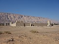 Jebel Hafeet, which the governorate shares with the U.A.E., as viewed from Mezyad Fort in the adjacent Emirati city of Al Ain
 -
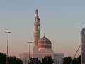 The Grand Mosque


History and prehistory
Being in the region of the Western Hajar,[14][15] the area of Al-Buraimi and Al-Ain, traditionally referred to as 'Tawam', is of historical and cultural importance.[16][17] It is demonstrated to have been inhabited as far back as the Hafit period of the early Bronze Age,[18] and according to one author, an oasis in this region and Al-Hasa in Saudi Arabia are the most important in the Arabian Peninsula.[19]
Al-Buraimi was part of Oman from early historical times. From around 600 CE, the Azdi tribes of Oman occupied the area. Then Al-Buraimi town was abandoned in the 700s. The area witnessed events relevant to the history of Islam during the Rashidun, Umayyad and Abbasid eras.[20] The area had come under the rule of the Wajihid Dynasty in the 9th century CE.[17] Al Nuaimi tribe, the original people of the town, rebuilt and ruled it in the 1800s to the 1950s. It had only two rulers, Sheikh Sulṭan bin Mohamed bin Ali Al-Hamood Al Qurtasi Al Naimi, then Sheikh Saqer bin Sulṭan bin Moḥammed Al Hamood Al Qurtasi Al Naimi. The late president of the United Arab Emirates, Sheikh Zayed bin Sultan Al Nahyan, was known to have been brought from Abu Dhabi to Al-Ain by his mother, Shaikhah Salaamah, following the assassination of his father Sultan bin Zayed in 1927.[3][4][21] Zayed was raised in a fortified house in the Muwaiji district of Al-Ain. Since 1761, Abu Dhabi was ruled by sheikhs of Al Abu Falah dynasty.[22]
The Buraimi Dispute
The community of Al-Buraimi is probably best known as the result of an incident known as the "Buraimi Dispute."[23] The dispute arose from Saudi Arabia's claim, first made in 1949, of sovereignty over a large part of Abu Dhabi territory where oil was suspected to be present and an area in a 20 miles (32 km) circle around the centre of the Buraimi Oasis. The Saudis relied on historical precedent (the oasis was under Wahhabi influence in the period between 1800 and 1870) for their claims, which were countered by arguments from Abu Dhabi and Muscat based on more recent events.
The argument led to the 1950 London Agreement, whereby exploration and troop movements in the area would continue until the issue of sovereignty was resolved. Despite ongoing negotiations, the Saudis attempted to take back the oasis.[24] In 1952 a group of some 80 Saudi Arabian guards, 40 of whom were armed, led by the Saudi Emir of Ras Tanura, Turki Abdullah Al Otaishan, crossed Abu Dhabi territory and occupied Hamasa, one of three Omani villages in the oasis, claiming it as part of the eastern Province of Saudi Arabia. The Sulṭan of Muscat and Imam of Oman gathered his forces to expel the Saudis but was persuaded by the British government to exercise restraint pending attempts to settle the dispute by arbitration.[25]
A standstill agreement was implemented and, on 30 July 1954, it was agreed to refer the dispute to an international arbitration tribunal.[26] Meanwhile, Saudi Arabia embarked on a campaign of bribery to obtain declarations of tribal loyalty on which its case was based. In 1955 arbitration proceedings began in Geneva only to collapse when the British arbitrator, Sir Reader Bullard, withdrew. A few weeks later, the Saudi party was forcibly ejected from Hamasa by the Trucial Oman Levies, a paramilitary group raised by the British. Together with a few refugee sheikhs and their families, the Saudis were taken to Sharjah and dispatched to Saudi Arabia by sea. The dispute was finally settled in 1974 by an agreement, known as the Treaty of Jeddah, between Sheikh Zayed (then President of the UAE) and King Faisal of Saudi Arabia.[25]
See also
- Eastern Arabia
- Al Qabil, village in Al Buraimi Governorate
- Archaeological Sites of Bat, Al-Khutm and Al-Ayn
- Jebel Ghawil
- University of Buraimi
References
- ^ "Population - DATA PORTAL". National Centre for Statistics & Information. Retrieved 15 October 2021.
- ^ "His Majesty appoints new ministers". Oman Daily Observer. 19 August 2020.
- ^ a b Al-Hosani, Hamad Ali (2012). The Political Thought of Zayed bin Sultan Al Nahyan (PhD Thesis) (Thesis). Durham University. pp. 43–44. Archived (PDF) from the original on 5 February 2017. Retrieved 15 April 2016.
- ^ a b El Reyes, Dr. Abdulla, ed. (December 2014). Liwa Journal of the National Archives (PDF). United Arab Emirates: Emirati National Archives. pp. 35–37. Archived from the original (PDF) on 6 February 2017. Retrieved 5 February 2017.
- ^ Law, Andy (20 September 2006). "Buraimi Travel Guide". World 66. Archived from the original on 27 September 2007. Retrieved 15 October 2007.
- ^ "Climatological Information - Buraimi". World Meteorological Organization. Retrieved 28 March 2016.
- ^ "Oman: Governorates". www.citypopulation.de.
- ^ Tesorero, Angel (29 January 2019). "Dubai-Muscat bus trip to be linked to 3 Metro stations". Khaleej Times. Dubai. Retrieved 30 January 2019.
- ^ Jordan, Benjamin R. (9 May 2013), "Route 4: Jebel Huwayya (Fossil Valley), Oman", Geotrekking in Southeastern Arabia: A Guide to Locations of World-Class Geology, Washington, D.C., the U.S.A.: American Geophysical Union, Wiley, pp. 38–40, doi:10.1029/SP065, ISBN 978-1-1186-7128-3, retrieved 8 March 2024
- ^ "جوامع السلطان قابوس". Sultan Qaboos (in Arabic). Retrieved 8 March 2024.
- ^ Aymerich, Olga (6 January 2016). "Oman Tourism: Exploring Buraimi". The Times of Oman. Retrieved 20 January 2019.
- ^ "Top 8 places of tourism in Buraimi, Sultanate of Oman". Arab Travelers. Retrieved 7 March 2024.
- ^ "Al Buraimi". Destination Oman. Retrieved 7 March 2024.
- ^ Abu-Lughod, Janet L. (2007). "Buraimi and Al-Ain". In Dumper, Michael R. T.; Stanley, Bruce E. (eds.). Cities of the Middle East and North Africa: A Historical Encyclopedia. ABC-CLIO. pp. 99–100. ISBN 978-1-5760-7919-5.
- ^ Allen, Calvin H. Jr. (5 February 2016). "1: Land and People". Oman: the Modernization of the Sultanate. Abingdon, New York: Routledge. pp. 1–8. ISBN 978-1-3172-9164-0.
- ^ Salama, Samir (30 December 2011). "Al Ain bears evidence of a culture's ability to adapt". Gulf News. Retrieved 7 August 2018.
- ^ a b Leech, Nick (22 October 2015). "The long read: has a lost Arab capital been found on the Oman-UAE border?". The National. Retrieved 20 January 2019.
- ^ Potts, Daniel T.; Nābūdah, Ḥasan Muḥammad; Hellyer, Peter (2003). Archaeology of the United Arab Emirates. London: Trident Press. pp. 174–177. ISBN 1-9007-2488-X. OCLC 54405078.
- ^ Cavendish, Marshall (2007). "Geography and climate". World and Its Peoples. Vol. 1. Cavendish Square Publishing. pp. 8–19. ISBN 978-0-7614-7571-2.
- ^ Abed, Ibrahim; Hellyer, Peter (2001). The United Arab Emirates, A New Perspective. London: Trident Press Ltd. pp. 60–86. ISBN 978-1-900724-47-0.
- ^ Killgore, Andrew I. (March 2005). "Sheikh Zayed bin Sultan Al Nahyan (1918–2004)". Washington Report on Middle East Affairs: 41. Archived (PDF) from the original on 5 February 2017. Retrieved 18 April 2013.
- ^ Rulers of the United Arab Emirates
- ^ "The Jebel Akhdar War Oman 1954-1959" by Major John B. Meagher (USMC) Global Security Report
- ^ Donald., Hawley (1970). The Trucial States. London: Allen & Unwin. ISBN 0-04-953005-4. OCLC 152680. P 188
- ^ a b Morton, Michael Quentin (2013). Buraimi: The Struggle for Power, Influence and Oil in Arabia. London: IB Tauris. p. 304. ISBN 978-1-84885-818-3.
- ^ UN
External links
- Bulletin
- Al Buraimi
- Al Buraymi West Mosque In Oman: Brief History, Architecture, Visiting Hours, & Travel Information
- Top 10 attractions to visit in Al Buraimi and around
Places adjacent to Al Buraimi Governorate | ||||||||||||||||
|---|---|---|---|---|---|---|---|---|---|---|---|---|---|---|---|---|
| ||||||||||||||||
| Governorates | ||
|---|---|---|
| Former regions (abolished in 2011): | ||
| Authority control databases: National |
|---|