
Oborniki: Difference between revisions
mNo edit summary |
m →top: Format administrative division links, remove DEFAULTSORTKEY as per WP:SORTKEY, remove One Source for stubs, minor formatting changes (AWB) |
||
| (26 intermediate revisions by 19 users not shown) | |||
| Line 1: | Line 1: | ||
{{for|the town in Lower Silesia|Oborniki Śląskie}} |
{{for|the town in Lower Silesia|Oborniki Śląskie}} |
||
{{Use dmy dates|date=September 2023}} |
|||
{{Infobox settlement |
{{Infobox settlement |
||
| name = Oborniki |
| name = Oborniki |
||
| image_skyline = Oborniki |
| image_skyline = Oborniki, Poland - panoramio (1).jpg |
||
| image_caption = |
| image_caption = Market Square (''Rynek'') in Oborniki |
||
| image_flag = POL Oborniki flag.svg |
| image_flag = POL Oborniki flag.svg |
||
| image_shield = POL Oborniki COA.svg |
| image_shield = POL Oborniki COA.svg |
||
| image_blank_emblem = LOGO GMINY OBORNIKI.svg |
|||
| blank_emblem_type = [[Brandmark]] |
|||
| pushpin_map = Poland |
| pushpin_map = Poland |
||
| ⚫ | |||
| coordinates_region = PL |
|||
| ⚫ | |||
| subdivision_name = {{POL}} |
| subdivision_name = {{POL}} |
||
| subdivision_type1 = [[Voivodeships of Poland|Voivodeship]] |
| subdivision_type1 = [[Voivodeships of Poland|Voivodeship]] |
||
| subdivision_name1 = |
| subdivision_name1 = {{flag|Greater Poland Voivodeship|name=Greater Poland}} |
||
| subdivision_type2 = [[ |
| subdivision_type2 = [[List of Polish counties|County]] |
||
| subdivision_name2 = [[Oborniki County]] |
| subdivision_name2 = [[Oborniki County|Oborniki]] |
||
| subdivision_type3 = [[Gmina]] |
| subdivision_type3 = [[Gmina]] |
||
| subdivision_name3 = [[Gmina Oborniki]] |
| subdivision_name3 = [[Gmina Oborniki|Oborniki]] |
||
| established_title2 = Town rights |
|||
| established_date2 = 13th century |
|||
| area_total_km2 = 14.08 |
| area_total_km2 = 14.08 |
||
| population_as_of = 2006 |
| population_as_of = 2006 |
||
| population_total = 17850 |
| population_total = 17850 |
||
| population_density_km2 = auto |
| population_density_km2 = auto |
||
| timezone = [[Central European Time|CET]] |
|||
| latd = 52 | latm = 39 | lats = | latNS = N | longd = 16 | longm = 49 | longs = | longEW = E |
|||
| |
| utc_offset = +1 |
||
| timezone_DST = [[Central European Summer Time|CEST]] |
|||
| utc_offset_DST = +2 |
|||
| ⚫ | |||
| elevation_m = |
|||
| postal_code_type = Postal code |
| postal_code_type = Postal code |
||
| postal_code = 64-600 |
| postal_code = 64-600 |
||
| area_code = +48 61 |
|||
| ⚫ | |||
| blank_name = [[Polish car number plates|License plates]] |
|||
| blank_info = POB |
|||
| ⚫ | |||
}} |
|||
| ⚫ | |||
==History== |
|||
| ⚫ | |||
[[File:Oborniki |
[[File:Oborniki - rynek, apteka. 1918-1939 (71516192).jpg|thumb|left|''Rynek'' (Market Square) in the interbellum]] |
||
Oborniki was granted [[town rights]] before 1292.<ref>Robert Krzysztofik, ''Lokacje miejskie na obszarze Polski. Dokumentacja geograficzno-historyczna'', Katowice 2007, p. 56-57</ref> Duke [[Bolesław the Pious]] founded a [[Franciscan]] monastery in Oborniki in the 13th century.<ref name=SL>{{cite web|url=https://www.oborniki.pl/turystyka/sladami-historii/|title=Śladami historii|website=UM Oborniki|access-date=August 10, 2019|language=pl}}</ref> It was a [[royal city in Poland|royal town]] of the [[Crown of the Kingdom of Poland]], administratively located in the Poznań County in the [[Poznań Voivodeship (14th century to 1793)|Poznań Voivodeship]] in the [[Greater Poland Province, Crown of the Kingdom of Poland|Greater Poland Province]].<ref>{{cite book|author=<!--Staff writer(s); no by-line.--> |title=Atlas historyczny Polski. Wielkopolska w drugiej połowie XVI wieku. Część I. Mapy, plany|year=2017|language=Polish|location=Warszawa|publisher=Instytut Historii [[Polish Academy of Sciences|Polskiej Akademii Nauk]]|page=1a}}</ref> It was frequently visited by King [[Władysław II Jagiełło]].<ref name=SL/> As a result of the [[Second Partition of Poland]] in 1793, it was annexed by [[Kingdom of Prussia|Prussia]]. After the successful [[Greater Poland uprising (1806)|Greater Poland uprising of 1806]], it was regained by Poles and became part of the short-lived [[Duchy of Warsaw]]. In 1815 it was annexed by Prussia for the second time. The townspeople fought in the struggles for liberation of Poland, including the [[November Uprising]], [[Greater Poland uprising (1848)]], [[January Uprising]] and the victorious post-[[World War I]] [[Greater Poland uprising (1918–19)|Greater Poland Uprising]], as a result of which the town was integrated with the reestablished [[Second Polish Republic|Polish state]] in 1919. |
|||
After the joint German-Soviet [[invasion of Poland]], which started [[World War II]] in September 1939, the town was [[Occupation of Poland (1939–1945)|occupied by Germany]] until 1945. The first [[Expulsion of Poles by Nazi Germany|expelled Poles]] were former insurgents of the Greater Poland Uprising, and the expulsions were carried out in early December 1939.<ref name=mw>{{cite book|last=Wardzyńska|first=Maria|year=2017|title=Wysiedlenia ludności polskiej z okupowanych ziem polskich włączonych do III Rzeszy w latach 1939-1945|language=Polish|location=Warszawa|publisher=[[Institute of National Remembrance|IPN]]|page=154|isbn=978-83-8098-174-4}}</ref> The expellees were held for several days in a transit camp in the nearby village of [[Kowanówko]], where they were robbed of money and valuables, and then they were deported in [[Rail freight transport|freight trains]] to [[Sokołów Podlaski]] in the [[General Government]] in the more-eastern part of German-occupied Poland.<ref name=mw/> In 1940, a transit camp for Poles expelled from various villages in the county was operated in the town.<ref>Wardzyńska, p. 198</ref> Some of the Poles expelled in 1940 from the nearby [[Chodzież County|Chodzież]] and [[Szamotuły County|Szamotuły]] counties were enslaved as [[Forced labour under German rule during World War II|forced labour]] in the town's vicinity.<ref>Wardzyńska, p. 201, 206</ref> The [[Grey Ranks]] printed [[Polish underground press]] in Oborniki, which was distributed throughout the county.<ref>{{cite book|author=<!--Staff writer(s); no by-line.--> |title=Encyklopedia konspiracji Wielkopolskiej 1939–1945|year=1998|location=Poznań|language=pl|publisher=Instytut Zachodni|page=96|isbn=83-85003-97-5}}</ref> In August 1944, the Germans carried out mass arrests of local members of the [[Home Army]], the leading [[Polish resistance movement in World War II|Polish underground resistance organization]].<ref>{{cite magazine|last=Ptakowska-Sysło|first=Agnieszka|year=2011|title=Konspiracja chodzieska 1939–1944|magazine=Biuletyn Instytutu Pamięci Narodowej|language=Polish|publisher=IPN|issue=5–6 (126–127)|page=67|issn=1641-9561}}</ref> |
|||
| ⚫ | |||
| ⚫ | |||
* [http://mapa.szukacz.pl/?x=351863&y=533114&m=Oborniki&w=wielkopolskie&p=obornicki&g=Oborniki&z=3 Map, via mapa.szukacz.pl] {{pl icon}} |
|||
==Sights== |
|||
| ⚫ | |||
Among the historic landmarks of Oborniki are:<ref name=SL/> |
|||
* the Market Square filled with historic townhouses |
|||
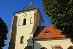
* the Church of the Assumption, dating back to the 15th century |
|||
* the [[timber framing|timber-framed]] Holy Cross church |
|||
* the [[Gothic Revival architecture in Poland|Gothic Revival]] Saint Joseph Church |
|||
==Cuisine== |
|||
Oborniki is one of the production sites of the Greater Poland liliput cheese (''ser liliput wielkopolski''), a traditional regional Polish [[cheese]], protected as a [[traditional food]] by the [[Ministry of Agriculture and Rural Development (Poland)|Ministry of Agriculture and Rural Development of Poland]].<ref>{{cite web|url=https://www.gov.pl/web/rolnictwo/ser-liliput-wielkopolski|title=Ser liliput wielkopolski|website=Ministerstwo Rolnictwa i Rozwoju Wsi - Portal Gov.pl|accessdate=30 May 2021|language=pl}}</ref> |
|||
==Sports== |
|||
The local [[Association football|football]] team is {{interlanguage link|Sparta Oborniki|pl|display=1}}. It competes in the lower leagues. |
|||
==International relations== |
|||
{{See also|List of twin towns and sister cities in Poland}} |
|||
Oborniki is [[Twin towns and sister cities|twinned]] with: |
|||
* {{flagicon|BEL}} [[Herk-de-Stad]], [[Belgium]]<ref>{{cite web|url=https://www.oborniki.pl/herk-de-stad/|title=Herk-de-stad|website=UM Oborniki|access-date=August 10, 2019|language=pl}}</ref> |
|||
* {{flagicon|GEO}} [[Kobuleti]], [[Georgia (country)|Georgia]]<ref>{{cite web|url=https://www.oborniki.pl/Kobuleti/|title=Kobuleti|website=UM Oborniki|access-date=August 10, 2019|language=pl}}</ref> |
|||
* {{flagicon|GER}} [[Lüchow]], [[Germany]]<ref>{{cite web|url=https://www.oborniki.pl/luchow/|title=Lüchow|website=UM Oborniki|access-date=August 11, 2019|language=pl}}</ref> |
|||
* {{flagicon|MLT}} [[Żejtun]], [[Malta]]<ref>{{cite web|url=https://www.zejtunlocalcouncil.com/|website=UM Zejtun|access-date=September 24, 2022|language=mt|title=Żejtun Local Council}}</ref> |
|||
==Gallery== |
|||
<gallery widths=150 heights=150> |
|||
Oborniki Wlkp. Holy Cross Church south 2010-10b.jpg|Holy Cross Church |
|||
Oborniki, Poland - panoramio.jpg|Church of the Assumption |
|||
Oborniki - kościół św. Jozefa. - panoramio.jpg|Saint Joseph church |
|||
MOs810, WG 2014 48, powiat obornicki (Oborniki water power station) (5).JPG|Hydroelectric power plant |
|||
</gallery> |
|||
[[File:Oborniki Pan01-05.jpg|thumb|center|upright=3.6|Panorama of the city]] |
|||
==References== |
|||
{{reflist}} |
|||
| ⚫ | |||
| ⚫ | |||
{{Oborniki County}} |
{{Oborniki County}} |
||
{{Gmina Oborniki}} |
{{Gmina Oborniki}} |
||
{{Authority control}} |
|||
[[Category:Cities and towns in Greater Poland Voivodeship]] |
[[Category:Cities and towns in Greater Poland Voivodeship]] |
||
[[Category:Oborniki County]] |
[[Category:Oborniki County]] |
||
[[Category:Populated places on the Warta]] |
|||
[[Category:Poznań Voivodeship (1921–1939)]] |
|||
{{GreaterPoland-geo-stub}} |
|||
Revision as of 02:25, 21 April 2024
Oborniki | |
|---|---|
.jpg) Market Square (Rynek) in Oborniki | |
 Flag  Coat of arms | |
 Oborniki | |
| Coordinates: 52°39′N 16°49′E / 52.650°N 16.817°E | |
| Country | |
| Voivodeship | |
| County | Oborniki |
| Gmina | Oborniki |
| Town rights | 13th century |
| Area | |
| • Total | 14.08 km2 (5.44 sq mi) |
| Population (2006) | |
| • Total | 17,850 |
| • Density | 1,300/km2 (3,300/sq mi) |
| Time zone | UTC+1 (CET) |
| • Summer (DST) | UTC+2 (CEST) |
| Postal code | 64-600 |
| Area code | +48 61 |
| License plates | POB |
| Website | https://www.oborniki.pl/ |

Oborniki [ɔbɔrˈɲikʲi] is a town in west-central Poland, in Greater Poland Voivodeship, about 30 km (19 mi) north of Poznań. It is the capital of Oborniki County and of Gmina Oborniki. Its population is 18,176 (2005).
History
.jpg)
Oborniki was granted town rights before 1292.[1] Duke Bolesław the Pious founded a Franciscan monastery in Oborniki in the 13th century.[2] It was a royal town of the Crown of the Kingdom of Poland, administratively located in the Poznań County in the Poznań Voivodeship in the Greater Poland Province.[3] It was frequently visited by King Władysław II Jagiełło.[2] As a result of the Second Partition of Poland in 1793, it was annexed by Prussia. After the successful Greater Poland uprising of 1806, it was regained by Poles and became part of the short-lived Duchy of Warsaw. In 1815 it was annexed by Prussia for the second time. The townspeople fought in the struggles for liberation of Poland, including the November Uprising, Greater Poland uprising (1848), January Uprising and the victorious post-World War I Greater Poland Uprising, as a result of which the town was integrated with the reestablished Polish state in 1919.
After the joint German-Soviet invasion of Poland, which started World War II in September 1939, the town was occupied by Germany until 1945. The first expelled Poles were former insurgents of the Greater Poland Uprising, and the expulsions were carried out in early December 1939.[4] The expellees were held for several days in a transit camp in the nearby village of Kowanówko, where they were robbed of money and valuables, and then they were deported in freight trains to Sokołów Podlaski in the General Government in the more-eastern part of German-occupied Poland.[4] In 1940, a transit camp for Poles expelled from various villages in the county was operated in the town.[5] Some of the Poles expelled in 1940 from the nearby Chodzież and Szamotuły counties were enslaved as forced labour in the town's vicinity.[6] The Grey Ranks printed Polish underground press in Oborniki, which was distributed throughout the county.[7] In August 1944, the Germans carried out mass arrests of local members of the Home Army, the leading Polish underground resistance organization.[8]
Sights
Among the historic landmarks of Oborniki are:[2]
- the Market Square filled with historic townhouses
- the Church of the Assumption, dating back to the 15th century
- the timber-framed Holy Cross church
- the Gothic Revival Saint Joseph Church
Cuisine
Oborniki is one of the production sites of the Greater Poland liliput cheese (ser liliput wielkopolski), a traditional regional Polish cheese, protected as a traditional food by the Ministry of Agriculture and Rural Development of Poland.[9]
Sports
The local football team is Sparta Oborniki. It competes in the lower leagues.
International relations
Oborniki is twinned with:
Gallery
-
 Holy Cross Church
 -
 Church of the Assumption
 -
 Saint Joseph church
 -
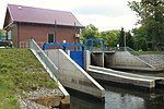 Hydroelectric power plant


_(5).JPG)

References
- ^ Robert Krzysztofik, Lokacje miejskie na obszarze Polski. Dokumentacja geograficzno-historyczna, Katowice 2007, p. 56-57
- ^ a b c "Śladami historii". UM Oborniki (in Polish). Retrieved 10 August 2019.
- ^ Atlas historyczny Polski. Wielkopolska w drugiej połowie XVI wieku. Część I. Mapy, plany (in Polish). Warszawa: Instytut Historii Polskiej Akademii Nauk. 2017. p. 1a.
- ^ a b Wardzyńska, Maria (2017). Wysiedlenia ludności polskiej z okupowanych ziem polskich włączonych do III Rzeszy w latach 1939-1945 (in Polish). Warszawa: IPN. p. 154. ISBN 978-83-8098-174-4.
- ^ Wardzyńska, p. 198
- ^ Wardzyńska, p. 201, 206
- ^ Encyklopedia konspiracji Wielkopolskiej 1939–1945 (in Polish). Poznań: Instytut Zachodni. 1998. p. 96. ISBN 83-85003-97-5.
- ^ Ptakowska-Sysło, Agnieszka (2011). "Konspiracja chodzieska 1939–1944". Biuletyn Instytutu Pamięci Narodowej (in Polish). No. 5–6 (126–127). IPN. p. 67. ISSN 1641-9561.
- ^ "Ser liliput wielkopolski". Ministerstwo Rolnictwa i Rozwoju Wsi - Portal Gov.pl (in Polish). Retrieved 30 May 2021.
- ^ "Herk-de-stad". UM Oborniki (in Polish). Retrieved 10 August 2019.
- ^ "Kobuleti". UM Oborniki (in Polish). Retrieved 10 August 2019.
- ^ "Lüchow". UM Oborniki (in Polish). Retrieved 11 August 2019.
- ^ "Żejtun Local Council". UM Zejtun (in Maltese). Retrieved 24 September 2022.
External links
- Official town website (in Polish)

| International | |
|---|---|
| National | |
| Geographic | |