
Trzebież: Difference between revisions
minor nitpicking |
Add to Port cities and towns in Poland and Port cities and towns of the Baltic Sea categories |
||
| (22 intermediate revisions by 12 users not shown) | |||
| Line 4: | Line 4: | ||
| settlement_type = Village |
| settlement_type = Village |
||
| total_type = |
| total_type = |
||
| image_skyline = |
| image_skyline = Trzebiez (dron 1).jpg |
||
| image_caption = |
| image_caption = Aerial view of Trzebież |
||
| image_flag = |
| image_flag = |
||
| image_shield = |
| image_shield = |
||
| image_map = |
| image_map = |
||
| subdivision_type = [[Countries of the world|Country]] |
| subdivision_type = [[Countries of the world|Country]] |
||
| subdivision_name = {{ |
| subdivision_name = {{POL}} |
||
| subdivision_type1 = [[Voivodeships of Poland|Voivodeship]] |
| subdivision_type1 = [[Voivodeships of Poland|Voivodeship]] |
||
| subdivision_name1 = [[West Pomeranian Voivodeship|West Pomeranian]] |
| subdivision_name1 = [[West Pomeranian Voivodeship|West Pomeranian]] |
||
| Line 17: | Line 17: | ||
| subdivision_type3 = [[Gmina]] |
| subdivision_type3 = [[Gmina]] |
||
| subdivision_name3 = [[Gmina Police|Police]] |
| subdivision_name3 = [[Gmina Police|Police]] |
||
| established_title = First mentioned |
|||
| ⚫ | |||
| established_date = {{circa|1180}} |
|||
| ⚫ | |||
| pushpin_map = Poland |
| pushpin_map = Poland |
||
| pushpin_label_position = bottom |
| pushpin_label_position = bottom |
||
| elevation_m = |
| elevation_m = |
||
| population_total = 2500 |
| population_total = 2500 |
||
|postal_code_type |
| postal_code_type = Postal code |
||
|postal_code |
| postal_code = 72-020 |
||
|area_code |
| area_code = +48 091 |
||
| timezone = [[Central European Time|CET]] |
|||
| ⚫ | |||
| utc_offset = +1 |
|||
| ⚫ | '''Trzebież''' {{IPAc-pl|'|t|sz|e|b|j|e|sz}} ( |
||
| timezone_DST = [[Central European Summer Time|CEST]] |
|||
| utc_offset_DST = +2 |
|||
| registration_plate = ZPL |
|||
| blank_name_sec2 = [[Voivodeship road]] |
|||
| blank_info_sec2 = [[File:DW114-PL.svg|32px|link=Voivodeship road 114]] |
|||
| ⚫ | |||
}} |
|||
| ⚫ | '''Trzebież''' {{IPAc-pl|'|t|sz|e|b|j|e|sz}} ({{lang-de|Ziegenort}})<ref>''Ortsnamenverzeichnis der Ortschaften jenseits von Oder und Neiße'' by M. Kaemmerer</ref> is a village in the administrative district of [[Gmina Police]], within [[Police County]], [[West Pomeranian Voivodeship]], in north-western Poland,<ref name="TERYT">{{cite web |url=http://www.stat.gov.pl/broker/access/prefile/listPreFiles.jspa |title=Central Statistical Office (GUS) – TERYT (National Register of Territorial Land Apportionment Journal) |date=1 June 2008 |language=pl}}</ref> close to the German border. It lies approximately {{convert|15|km|mi|0}} north of [[Police, West Pomeranian Voivodeship|Police]] and {{convert|28|km|mi|0|abbr=on}} north of the regional capital [[Szczecin]]. |
||
The village |
The village lies on the [[Szczecin Lagoon]], and has a harbour, a [[marina]], a beach and a school of [[sailing]]. |
||
== History == |
== History == |
||
In the early 12th century, the territory formed part of Poland, and following the country's fragmentation into smaller duchies, it formed part of the [[Duchy of Pomerania]], and smaller splinter duchies. The first chronicle mentions of Trzebież come from around 1280, when Duke [[Boguslaw IV|Bogusław IV]] gave the village to a burgher from Szczecin. The settlement suffered heavy losses during the [[Thirty Years' War|Thirty Years']] and [[Seven Years' War]]s. In the following centuries, Trzebież developed as a typical settlement on the Szczecin Lagoon. In the 18th century, the village gained its own self-government. From 1815, it formed part of the [[Province of Pomerania (1815–1945)|Province of Pomerania]] of the [[Kingdom of Prussia]], and from 1871 also of the [[German Empire]], within which it was known as ''Ziegenort''. At the end of the 19th century, passenger and transit ports, as well as a shipyard, were built here. After 1898, Trzebież gained a railway connection with Police, and in 1910 a regular passenger connection was launched. By 1930, the waters of the lagoon revealed a beach of clean sand. This initiated the development of tourism. |
|||
Before 1945 the area was part of Germany. For the history of the region, see [[History of Pomerania]]. |
|||
During [[World War II]], the settlement suffered approximately 40% of its buildings (mainly the port and the sawmill). There was also a temporary camp for Polish [[Forced labour under German rule during World War II|forced laborers]] here. Trzebież was occupied on April 27, 1945, by Soviet (2nd Belorussian Front – [[2nd Shock Army]]) and [[First Polish Army (1944–45)|Polish]] troops. The territory became again part of Poland after the end of World War II in accordance with the [[Potsdam Agreement]], and changed its name to the [[Polish language|Polish]] ''Trzebież'', however, it was initially administered by the Soviets as part of the so-called [[Enclave of Police]]. It was placed under Polish administration in September 1946 after the liquidation of the so-called enclave.<ref name=b1>Encyklopedia Szczecina. T. Suplement 1. Szczecin: Uniwersytet Szczeciński, 2003, p. 273. ISBN 83-7241-272-3. (pol.).</ref> |
|||
Trzebież, known as ''Ziegenort'' to its residents while part of Germany until 1945, became part of [[Poland]] after the end of World War II and changed its name to the [[Polish Language|Polish]] ''Trzebież''. |
|||
For several post-war months, the village was called Zatoka by the first Polish settlers.<ref name=b1/> In 1946, the Zaodrzańskie Forest Management Board was established here, later transformed into the Trzebież Forest District. By 1948, the port, shipyards and sawmill were reopened, and the "Certa" fishing cooperative was established. The settlement began to develop dynamically. Trzebież's greatest prosperity took place in the 1970s[2], it was then the largest Polish port on the Szczecin Lagoon.<ref>Czesław Piskorski, Pomorze Zachodnie, mały przewodnik, Warsaw: Wyd. Sport i Turystyka Warsaw, 1980, pp. 292–293, ISBN 83-217-2292-X, OCLC 8032482.</ref> Administratively, it was located until 1975 in the [[Szczecin Voivodeship (1946–1975)|"large"]] and then until 1998 in the [[Szczecin Voivodeship (1975–1998)|"small"]] Szczecin Voivodeship. |
|||
| ⚫ | |||
On 24 November 2018, as a result of arson, a several hundred-meter-long wooden walking promenade by the Szczecin Lagoon burned down. |
|||
'''Political-administrative membership''' |
|||
* [[File:War ensign of the German Empire Navy 1848-1852.svg|18px]] 1815–1866: [[German Confederation]], [[Kingdom of Prussia]], [[Pomerania]] |
|||
*[[File:Flag of the German Empire.svg|19px]] 1866–1871: [[North German Confederation]], [[Kingdom of Prussia]], [[Pomerania]] |
|||
* [[File:Flag of the German Empire.svg|19px]] 1871–1918: [[German Empire]], [[Kingdom of Prussia]], [[Pomerania]] |
|||
* [[File:Flag of Germany (3-2 aspect ratio).svg|19px]] 1919–1933: [[Weimarer Republik]], [[Free State of Prussia]], [[Pomerania]] |
|||
* [[File:Flag of Germany 1933.svg|19px]] 1933–1945: [[Nazi Germany]], [[Pomerania]] |
|||
* [[File:Red Army flag.svg|19px]] 1945–1946: [[Enclave Police]], (the area reporting to the [[Red Army]]) |
|||
* [[File:Flag of Poland.svg|19px]] 1946–1952: [[People's Republic of Poland]], [[Szczecin Voivodeship]] |
|||
* [[File:Flag of Poland.svg|19px]] 1952–1975: [[People's Republic of Poland]], [[Szczecin Voivodeship]] |
|||
* [[File:Flag of Poland.svg|19px]] 1975–1989: [[People's Republic of Poland]], [[Szczecin Voivodeship]] |
|||
* [[File:Flag of Poland.svg|19px]] 1989–1998: [[Poland]], [[Szczecin Voivodeship]] |
|||
* [[File:Flag of Poland.svg|19px]] 1999 - Current: [[Poland]], [[West Pomeranian Voivodeship|Western Pomerania]], [[powiat]] [[Police County]], [[gmina]] Police |
|||
| ⚫ | |||
'''Monuments''' |
|||
* Parish church in Trzebiez (1745) |
|||
* Houses from the 19th century |
|||
'''Demography''' |
|||
* The village has a population: |
|||
** 1864–1823 |
|||
** 1905–1808 |
|||
** 1925–2382 |
|||
** 1939–2660 |
|||
** 1960–1897 |
|||
** 1972–2240 |
|||
** 2001–2000 |
|||
** 2006–2500 |
|||
<gallery> |
<gallery> |
||
File:PorRybTrb.JPG|Trzebież, Fish Harbor |
File:PorRybTrb.JPG|Trzebież, Fish Harbor |
||
File:SM Trzebież Kościół Podwyższenia Krzyża Świętego 2019 (0).jpg|Exaltation of the Holy Cross church from 1745 |
|||
File:KościółTrb.JPG|Parish church from 1745 |
|||
File:1504 Trzebież Plaża ZPL.jpg|Beach |
File:1504 Trzebież Plaża ZPL.jpg|Beach and promenade in Trzebież |
||
File:Trzebiez port (dron1).jpg|Port of Trzebież |
|||
File:Trzebiez stacja kolejowa (dron 1).jpg|Railway station |
|||
</gallery> |
</gallery> |
||
| Line 74: | Line 62: | ||
* [[PTTK]] [[Trail|path]] (green footpath [[File:POL Szlak czerwony.svg|25px]] ''Trail Puszczy Wkrzańskiej''-''Szlak Puszczy Wkrzańskiej'') in an area of Trzebież in [[Wkrzanska Forest]] |
* [[PTTK]] [[Trail|path]] (green footpath [[File:POL Szlak czerwony.svg|25px]] ''Trail Puszczy Wkrzańskiej''-''Szlak Puszczy Wkrzańskiej'') in an area of Trzebież in [[Wkrzanska Forest]] |
||
* Bicycle trail (red [[File:Szlak rowerowy czerwony.svg|23px]] ''Trail "Puszcza Wkrzańska"''-''Szlak "Puszcza Wkrzańska"'') in an area of Trzebież in [[Wkrzanska Forest]] |
* Bicycle trail (red [[File:Szlak rowerowy czerwony.svg|23px]] ''Trail "Puszcza Wkrzańska"''-''Szlak "Puszcza Wkrzańska"'') in an area of Trzebież in [[Wkrzanska Forest]] |
||
* [[Łarpia Sail Festival]] |
|||
== See also == |
== See also == |
||
| Line 85: | Line 72: | ||
{{Gmina Police}} |
{{Gmina Police}} |
||
{{Coord|53|39|23|N|14|30|30|E|region:PL_type:city|display=title}} |
|||
{{DEFAULTSORT:Trzebiez}} |
|||
[[Category:Villages in Police County]] |
[[Category:Villages in Police County]] |
||
[[Category:Port cities and towns of the Baltic Sea]] |
|||
[[Category:Port cities and towns in Poland]] |
|||
Latest revision as of 12:16, 15 February 2024
Trzebież | |
|---|---|
Village | |
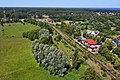
.jpg) Aerial view of Trzebież | |
 Trzebież | |
| Coordinates: 53°39′23″N 14°30′30″E / 53.65639°N 14.50833°E | |
| Country | |
| Voivodeship | West Pomeranian |
| County | Police |
| Gmina | Police |
| First mentioned | c. 1180 |
| Population | 2,500 |
| Time zone | UTC+1 (CET) |
| • Summer (DST) | UTC+2 (CEST) |
| Postal code | 72-020 |
| Area code | +48 091 |
| Vehicle registration | ZPL |
| Voivodeship road | |
| Website | http://www.trzebiez.pl/ |
Trzebież [ˈtʂɛbjɛʂ] (German: Ziegenort)[1] is a village in the administrative district of Gmina Police, within Police County, West Pomeranian Voivodeship, in north-western Poland,[2] close to the German border. It lies approximately 15 kilometres (9 mi) north of Police and 28 km (17 mi) north of the regional capital Szczecin.
The village lies on the Szczecin Lagoon, and has a harbour, a marina, a beach and a school of sailing.
History
[edit]In the early 12th century, the territory formed part of Poland, and following the country's fragmentation into smaller duchies, it formed part of the Duchy of Pomerania, and smaller splinter duchies. The first chronicle mentions of Trzebież come from around 1280, when Duke Bogusław IV gave the village to a burgher from Szczecin. The settlement suffered heavy losses during the Thirty Years' and Seven Years' Wars. In the following centuries, Trzebież developed as a typical settlement on the Szczecin Lagoon. In the 18th century, the village gained its own self-government. From 1815, it formed part of the Province of Pomerania of the Kingdom of Prussia, and from 1871 also of the German Empire, within which it was known as Ziegenort. At the end of the 19th century, passenger and transit ports, as well as a shipyard, were built here. After 1898, Trzebież gained a railway connection with Police, and in 1910 a regular passenger connection was launched. By 1930, the waters of the lagoon revealed a beach of clean sand. This initiated the development of tourism.
During World War II, the settlement suffered approximately 40% of its buildings (mainly the port and the sawmill). There was also a temporary camp for Polish forced laborers here. Trzebież was occupied on April 27, 1945, by Soviet (2nd Belorussian Front – 2nd Shock Army) and Polish troops. The territory became again part of Poland after the end of World War II in accordance with the Potsdam Agreement, and changed its name to the Polish Trzebież, however, it was initially administered by the Soviets as part of the so-called Enclave of Police. It was placed under Polish administration in September 1946 after the liquidation of the so-called enclave.[3]
For several post-war months, the village was called Zatoka by the first Polish settlers.[3] In 1946, the Zaodrzańskie Forest Management Board was established here, later transformed into the Trzebież Forest District. By 1948, the port, shipyards and sawmill were reopened, and the "Certa" fishing cooperative was established. The settlement began to develop dynamically. Trzebież's greatest prosperity took place in the 1970s[2], it was then the largest Polish port on the Szczecin Lagoon.[4] Administratively, it was located until 1975 in the "large" and then until 1998 in the "small" Szczecin Voivodeship.
On 24 November 2018, as a result of arson, a several hundred-meter-long wooden walking promenade by the Szczecin Lagoon burned down.
Below is a timeline showing the history of the different administrations in which this city has been.
-
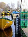 Trzebież, Fish Harbor
 -
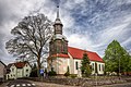 Exaltation of the Holy Cross church from 1745
 -
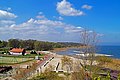 Beach and promenade in Trzebież
 -
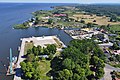 Port of Trzebież
 -
 Railway station

.jpg)

.jpg)
.jpg)
Tourism
[edit]- PTTK path (green footpath
 Trail Puszczy Wkrzańskiej-Szlak Puszczy Wkrzańskiej) in an area of Trzebież in Wkrzanska Forest
 - Bicycle trail (red
 Trail "Puszcza Wkrzańska"-Szlak "Puszcza Wkrzańska") in an area of Trzebież in Wkrzanska Forest
See also
[edit]References
[edit]- ^ Ortsnamenverzeichnis der Ortschaften jenseits von Oder und Neiße by M. Kaemmerer
- ^ "Central Statistical Office (GUS) – TERYT (National Register of Territorial Land Apportionment Journal)" (in Polish). 1 June 2008.
- ^ a b Encyklopedia Szczecina. T. Suplement 1. Szczecin: Uniwersytet Szczeciński, 2003, p. 273. ISBN 83-7241-272-3. (pol.).
- ^ Czesław Piskorski, Pomorze Zachodnie, mały przewodnik, Warsaw: Wyd. Sport i Turystyka Warsaw, 1980, pp. 292–293, ISBN 83-217-2292-X, OCLC 8032482.
| Town and seat |  | |
|---|---|---|
| Villages | ||