
Barroosky: Difference between revisions
Guliolopez (talk | contribs) ED population. 2022 census. |
Guliolopez (talk | contribs) →Glenamoy bog: ce |
||
| (2 intermediate revisions by the same user not shown) | |||
| Line 22: | Line 22: | ||
| blank_name_sec1 = [[Irish grid reference system|Irish Grid Reference]] |
| blank_name_sec1 = [[Irish grid reference system|Irish Grid Reference]] |
||
| blank_info_sec1 = F 94231 30017 |
| blank_info_sec1 = F 94231 30017 |
||
| coordinates = {{coord|54. |
| coordinates = {{coord|54.2083|-9.6220|dim:100000_region:IE-MO|format=dms|display=inline,title}} |
||
| native_name = {{pad top italic|Barr Rúscaígh}} |
| native_name = {{pad top italic|Barr Rúscaígh}} |
||
| native_name_lang = ie |
| native_name_lang = ie |
||
| Line 43: | Line 43: | ||
=== Glenamoy bog === |
=== Glenamoy bog === |
||
The Glenamoy bog complex is a large site situated in the extreme north-west of [[Erris]], County Mayo |
The Glenamoy bog complex, which spans parts of Barroosky,<ref name="npws">{{Cite web |url=http://www.npws.ie/en/media/Media,3965,en.pdf |title=Site Synopsis - Glenamoy Bog Complex | work = National Parks and Wildlife Service | access-date=14 April 2010 |archive-url=https://web.archive.org/web/20071218152314/http://www.npws.ie/en/media/Media,3965,en.pdf |archive-date=18 December 2007 |url-status=dead }}</ref> is a large site situated in the extreme north-west of [[Erris]], County Mayo.<ref>{{Cite web|url=https://eunis.eea.europa.eu/sites/IE0000500#tab-habitats|title=EUNIS -Site factsheet for Glenamoy Bog Complex SAC|website=eunis.eea.europa.eu|access-date=2018-12-11}}</ref> The area, which incorporates both inland and coastal regions, has a wet and oceanic climate and there are frequent strong winds across the largely treeless and relatively exposed area. The bog complex is drained by four main river systems - the [[Glenamoy River|Glenamoy]], the [[Muingnabo River|Muingnabo]], the Belderg and the Glenglassra rivers. Extreme oceanic blanket bog dominates the site in its inland areas.<ref name=":1" /> |
||
=== Sheskin forestry === |
=== Sheskin forestry === |
||
Latest revision as of 20:57, 2 January 2024
Barroosky
Barr Rúscaígh | |
|---|---|
Townland | |
 View of Barroosky | |
 Barroosky Location in Ireland | |
| Coordinates: 54°12′30″N 9°37′19″W / 54.2083°N 9.6220°W | |
| Country | Ireland |
| Province | Connacht |
| County | County Mayo |
| Area | |
| • Total | 7.78 km2 (3.00 sq mi) |
| Time zone | WET |
| • Summer (DST) | IST (WEST) |
| Irish Grid Reference | F 94231 30017 |
| As this is in the Gaeltacht, the Irish Barr Rúscaígh is the only official name. The anglicized spelling Barroosky has no official status. | |
Barroosky (also spelt as Barroskey or Barrooskey. Irish: Barr Rúscaígh, meaning "top of the undulation")[1] is a Gaeltacht townland within the civil parish of Kilcommon in County Mayo, Ireland.[2] It is located within the ecclesiastical parish of Kilcommon-Erris.[3] Barroosky townland has an area of approximately 1,923 acres (7.8 km2).[2]
Barroosky is also the name of the electoral division (ED) in which the townland lies.[2] As of 2022, Barroosky ED had a population of 96 people.[4]
History
[edit]
In Irish folklore, Barroosky is mentioned in the epic tale of Táin Bó Flidhais. It also is mentioned in a popular Erris folktale called the Fool of Barr Rúscaígh as part of the year of the French celebrations.[5] In 1911, the population was recorded as 34.[6]
In September 1922, during the Irish Civil War, the Battle of Glenamoy took place nearby.[7]
Agriculture and geography
[edit]The area in which the Barroosky lies on is mostly covered in peaty, blanket bog which covers much of the North Mayo coastlines of Kilcommon and the Barony of Erris.[8]
Glenamoy bog
[edit]The Glenamoy bog complex, which spans parts of Barroosky,[9] is a large site situated in the extreme north-west of Erris, County Mayo.[10] The area, which incorporates both inland and coastal regions, has a wet and oceanic climate and there are frequent strong winds across the largely treeless and relatively exposed area. The bog complex is drained by four main river systems - the Glenamoy, the Muingnabo, the Belderg and the Glenglassra rivers. Extreme oceanic blanket bog dominates the site in its inland areas.[8]
Sheskin forestry
[edit]Barroosky is situated near to the Sheskin Forest (not to be confused with Sheskin, County Monaghan) which stretches from near Ballycastle to Bellacorick. The forest is a large area of conifer forest plantation established on the bog lands of north Mayo.[11] A hunting lodge built by the McDonnell family and later owned by the Jameson family, now in ruins lies there.[12][13][14]
Gallery
[edit]-
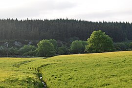 Drainage in a field
 -
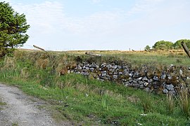 Dry stone walling
 -
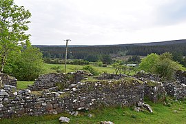 Ruin of a house
 -
![A view of Slieve Fyagh (335 Metres).[15]](//upload.wikimedia.org/wikipedia/commons/thumb/f/f3/A_view_of_Slieve_Fyagh_from_Barrooskey.jpg/270px-A_view_of_Slieve_Fyagh_from_Barrooskey.jpg) A view of Slieve Fyagh (335 Metres).[15]
A view of Slieve Fyagh (335 Metres).[15] -
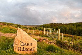 View of a sign


![A view of Slieve Fyagh (335 Metres).[15]](/https/en.wikipedia.org/wiki/File:A_view_of_Slieve_Fyagh_from_Barrooskey.jpg)

References
[edit]- ^ Noone, Fr Sean (1991). Where The Sun Sets (1st ed.). Naas: The Leinster Leader. p. 148. ISBN 0951817906.
{{cite book}}: CS1 maint: date and year (link) - ^ a b c "Barroosky Townland, Co. Mayo". www.townlands.ie. Retrieved 11 December 2018.
- ^ "Parish of Kilcommon Erris, County Mayo, Ireland". Retrieved 11 December 2018.
- ^ "FP009 - Population and Actual and Percentage Change 2016 to 2022". data.gov.ie. Central Statistics Office. Retrieved 2 January 2024.
Barr Rúscaí, Co.Mayo, 29054 [..] Electoral Division [..] Population - 2022 [..] 96
- ^ Beiner, Guy (2007). Remembering the Year of the French: Irish Folk History and Social Memory. Univ of Wisconsin Press. ISBN 9780299218249.
- ^ "Census of Ireland, 1911". www.census.nationalarchives.ie. Retrieved 2 December 2021.
- ^ "Civil War in Mayo: The Battle of Glenamoy, 1922 by Thomas Langan | Family History in North County Mayo". goldenlangan.com. Retrieved 9 December 2018.
- ^ a b "Glenamoy Bog Complex SAC". Protected Planet. Retrieved 11 December 2018.
- ^ "Site Synopsis - Glenamoy Bog Complex" (PDF). National Parks and Wildlife Service. Archived from the original (PDF) on 18 December 2007. Retrieved 14 April 2010.
- ^ "EUNIS -Site factsheet for Glenamoy Bog Complex SAC". eunis.eea.europa.eu. Retrieved 11 December 2018.
- ^ "Sheskin North". Coillte. Retrieved 11 December 2018.
- ^ "Estate Record: Jameson (Sheskin)". landedestates.nuigalway.ie. Retrieved 11 December 2018.
- ^ "HUSSEY DE BURGH, U. H. The Landowners of Ireland. An alphabetical list of the owners of estates of 500 acres or £500 valuation and upwards in Ireland. Dublin: Hodges, Foster and Figgis, 1878. [available online at www.askaboutireland.ie]". landedestates.nuigalway.ie. Retrieved 11 December 2018.
- ^ Connolly, Linda (August 2004). "The limits of 'Irish Studies': historicism, culturalism, paternalism". Irish Studies Review. 12 (2): 139–162. doi:10.1080/0967088042000228914. ISSN 0967-0882. S2CID 145506909.
- ^ "Slieve Fyagh 335m hill, North Mayo Ireland at MountainViews.ie". mountainviews.ie. Retrieved 21 December 2018.
