
Outcrop: Difference between revisions
image gallery |
CodeTalker (talk | contribs) Reverted 2 edits by TealComet (talk): Rvt per MOS:OVERLINK |
||
| (21 intermediate revisions by 16 users not shown) | |||
| Line 1: | Line 1: | ||
{{Short description|Visible exposure of bedrock or ancient superficial deposits on the surface of the Earth}} |
|||
[[Image:San_Carlos_Water,_Falkland_Islands.jpg|upright|thumb|View of a bedrock outcrop near [[San Carlos Water]], [[Falkland Islands]]]] |
|||
{{ |
{{More citations needed|date=September 2011}} |
||
[[File:Rockeskyller Kopf 3.JPG|thumb|Outcrop of volcanic rock in Germany]] |
|||
An '''outcrop''' |
An '''outcrop''' or '''rocky outcrop''' is a visible exposure of [[bedrock]] or ancient [[superficial deposits]] on the surface of the Earth.<ref>Howell, J. V., 1960, ''Glossary of Geology and Related Sciences''. Washington, DC: American Geological Institute, pp. 207-208</ref> |
||
==Features== |
==Features== |
||
Outcrops do not cover the majority of the Earth's land surface because in most places the bedrock or superficial deposits are covered by |
Outcrops do not cover the majority of the Earth's land surface because in most places the bedrock or superficial deposits are covered by [[soil]] and vegetation and cannot be seen or examined closely. However, in places where the overlying cover is removed through [[erosion]] or [[tectonic uplift]], the rock may be exposed, or ''crop out''. Such exposure will happen most frequently in areas where [[erosion]] is rapid and exceeds the [[weathering]] rate such as on steep hillsides, mountain ridges and tops, river banks, and [[tectonic uplift|tectonically active]] areas. In [[Finland]], [[Glacier|glacial]] erosion during the last glacial maximum (ca. 11000 BC), followed by scouring by sea waves, followed by [[Postglacial rebound|isostatic uplift]] has produced many smooth coastal and littoral outcrops. |
||
Bedrock and superficial deposits may also be exposed at the Earth's surface due to human excavations such as quarrying and building of transport routes. |
Bedrock and superficial deposits may also be exposed at the Earth's surface due to human excavations such as quarrying and building of transport routes. |
||
| Line 16: | Line 16: | ||
==Examples== |
==Examples== |
||
On [[Ordnance Survey]] maps in [[Great Britain]], cliffs are distinguished from outcrops: cliffs have a continuous line along the top edge with lines protruding down; outcrops have a continuous line around each area of bare rock. An outcrop example in [[California]] is the [[Vasquez Rocks]], familiar from [[location shooting]] use in many [[movie|films]], composed of uplifted [[sandstone]].<ref> |
On [[Ordnance Survey]] maps in [[Great Britain]], cliffs are distinguished from outcrops: cliffs have a continuous line along the top edge with lines protruding down; outcrops have a continuous line around each area of bare rock. An outcrop example in [[California]] is the [[Vasquez Rocks]], familiar from [[location shooting]] use in many [[movie|films]], composed of uplifted [[sandstone]].<ref>{{Cite web |url=http://employees.oxy.edu/jerry//vazquez.htm |title=oxy.edu. Vazquez Rocks. access date:5/22/2010 |access-date=2010-05-24 |archive-url=https://web.archive.org/web/20110608223233/http://employees.oxy.edu/jerry//vazquez.htm |archive-date=2011-06-08 |url-status=dead }}</ref><ref>{{Cite web |url=http://parks.lacounty.gov/Parkinfo.asp?URL=cms1_033383.asp&Title=Vasquez%20%20Rocks%20Natural%20Area%20and%20Center |title=parks.lacounty.gov. Vazquez Rocks Natural Area and Nature Center. access date:5/22/2010 |access-date=2010-05-24 |archive-date=2012-09-20 |archive-url=https://web.archive.org/web/20120920004535/http://parks.lacounty.gov/Parkinfo.asp?URL=cms1_033383.asp&Title=Vasquez%20%20Rocks%20Natural%20Area%20and%20Center |url-status=dead }}</ref> [[Yana, India|Yana]] is another example of outcrops, located in [[Uttara Kannada]] district in [[Karnataka]], [[India]]. |
||
<gallery mode=packed heights= |
<gallery mode="packed" heights="150"> |
||
File:Serrotebranco.JPG|Serrote Branco outcrop in [[Caicó]], [[Brazil]] |
File:Serrotebranco.JPG|Serrote Branco outcrop in [[Caicó]], [[Brazil]] |
||
File: |
File:Granodiorite of the Fennoscandian Shield.jpg|[[Precambrian]] outcrop in Finland |
||
File:Śląskie Kamienie - Dívči Kameny.JPG|[[Granite]] outcrops at [[Śląskie Kamienie|Silesian Stones]] Mountain in southwestern [[Poland]] |
File:Śląskie Kamienie - Dívči Kameny.JPG|[[Granite]] outcrops at [[Śląskie Kamienie|Silesian Stones]] Mountain in southwestern [[Poland]] |
||
File:Yana Rock no border.jpg|Outcrop near [[Yana, India]] |
File:Yana Rock no border.jpg|Outcrop near [[Yana, India]] |
||
File:Roubidoux sandstone bluff.JPG|Outcrop of the [[Roubidoux Formation]] in the [[Ozarks]] of southern [[Missouri]] |
File:Roubidoux sandstone bluff.JPG|Outcrop of the [[Roubidoux Formation]] in the [[Ozarks]] of southern [[Missouri]] |
||
File:Vasquez Rocks County Park.jpg|Outcrop in the [[Vasquez Rocks Natural Area Park]] of southern [[California]] |
File:Vasquez Rocks County Park.jpg|Outcrop in the [[Vasquez Rocks Natural Area Park]] of southern [[California]] |
||
File:12 1072m - Valley of Desolation.jpg|Valley of Desolation in the [[Camdeboo National Park]] |
|||
</gallery> |
</gallery> |
||
==See also== |
==See also== |
||
{{Portal|Earth sciences}} |
{{Portal|Earth sciences}} |
||
{{Wiktionary}} |
|||
*[[Digital outcrop model]] |
*[[Digital outcrop model]] |
||
*[[Geological formation]] |
*[[Geological formation]] |
||
| Line 38: | Line 38: | ||
==External links== |
==External links== |
||
{{Commons-inline |
* {{Commons category-inline|Outcrops}} |
||
{{-}} |
* {{Wiktionary-inline}} |
||
{{Physical Earth|state=collapsed}} |
|||
{{Authority control}} |
|||
[[Category:Rock formations]] |
[[Category:Rock formations]] |
||
Latest revision as of 01:57, 29 December 2023
This article needs additional citations for verification. (September 2011) |

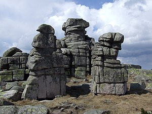
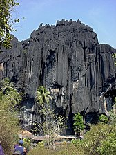
An outcrop or rocky outcrop is a visible exposure of bedrock or ancient superficial deposits on the surface of the Earth.[1]
Features
[edit]Outcrops do not cover the majority of the Earth's land surface because in most places the bedrock or superficial deposits are covered by soil and vegetation and cannot be seen or examined closely. However, in places where the overlying cover is removed through erosion or tectonic uplift, the rock may be exposed, or crop out. Such exposure will happen most frequently in areas where erosion is rapid and exceeds the weathering rate such as on steep hillsides, mountain ridges and tops, river banks, and tectonically active areas. In Finland, glacial erosion during the last glacial maximum (ca. 11000 BC), followed by scouring by sea waves, followed by isostatic uplift has produced many smooth coastal and littoral outcrops.
Bedrock and superficial deposits may also be exposed at the Earth's surface due to human excavations such as quarrying and building of transport routes.
Study
[edit]Outcrops allow direct observation and sampling of the bedrock in situ for geologic analysis and creating geologic maps. In situ measurements are critical for proper analysis of geological history and outcrops are therefore extremely important for understanding the geologic time scale of earth history. Some of the types of information that cannot be obtained except from bedrock outcrops or by precise drilling and coring operations, are structural geology features orientations (e.g. bedding planes, fold axes, foliation), depositional features orientations (e.g. paleo-current directions, grading, facies changes), paleomagnetic orientations. Outcrops are also very important for understanding fossil assemblages, and paleo-environment, and evolution as they provide a record of relative changes within geologic strata.
Accurate description, mapping, and sampling for laboratory analysis of outcrops made possible all of the geologic sciences and the development of fundamental geologic laws such as the law of superposition, the principle of original horizontality, principle of lateral continuity, and the principle of faunal succession.
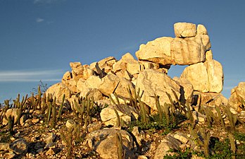
Examples
[edit]On Ordnance Survey maps in Great Britain, cliffs are distinguished from outcrops: cliffs have a continuous line along the top edge with lines protruding down; outcrops have a continuous line around each area of bare rock. An outcrop example in California is the Vasquez Rocks, familiar from location shooting use in many films, composed of uplifted sandstone.[2][3] Yana is another example of outcrops, located in Uttara Kannada district in Karnataka, India.
-
-
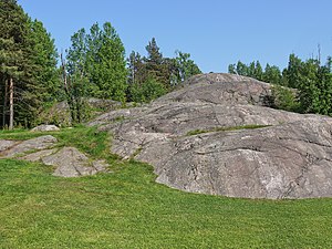 Precambrian outcrop in Finland
 -
-
 Outcrop near Yana, India
 -
-
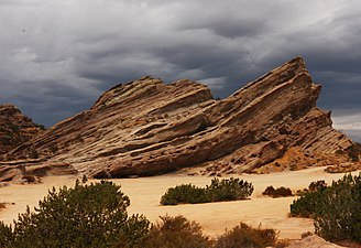 Outcrop in the Vasquez Rocks Natural Area Park of southern California
 -
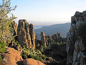 Valley of Desolation in the Camdeboo National Park


See also
[edit]References
[edit]- ^ Howell, J. V., 1960, Glossary of Geology and Related Sciences. Washington, DC: American Geological Institute, pp. 207-208
- ^ "oxy.edu. Vazquez Rocks. access date:5/22/2010". Archived from the original on 2011-06-08. Retrieved 2010-05-24.
- ^ "parks.lacounty.gov. Vazquez Rocks Natural Area and Nature Center. access date:5/22/2010". Archived from the original on 2012-09-20. Retrieved 2010-05-24.
External links
[edit]| Authority control databases: National |
|---|