
South Limburg (Netherlands): Difference between revisions
| (32 intermediate revisions by 23 users not shown) | |||
| Line 1: | Line 1: | ||
{{Short description|Region in Limburg, the Netherlands}} |
|||
[[File:Panorama heuvelland Maurice van Bruggen.JPG|thumb|Hills in South Limburg |
[[File:Panorama heuvelland Maurice van Bruggen.JPG|550px|thumb|{{center|Hills in South Limburg}}]] |
||
'''South Limburg''' ([[Dutch language|Dutch]]: ''Zuid-Limburg'', [[Limburgish]]: ''Zuud-Limburg'') is both a [[COROP|COROP (statistical) region]] as well as a ''[[List of subregions of the Netherlands|landstreek]]'' (area) of the [[Netherlands]] located in the [[Limburg (Netherlands)|province of Limburg]]. The Dutch term ''landstreek'', literally translated "land area/region", means that the area is not an administrative region but an area that displays cohesion with |
'''South Limburg''' ([[Dutch language|Dutch]]: ''Zuid-Limburg'', [[Limburgish]]: ''Zuud-Limburg'') is both a [[COROP|COROP (statistical) region]] as well as a ''[[List of subregions of the Netherlands|landstreek]]'' (area) of the [[Netherlands]] located in the [[Limburg (Netherlands)|province of Limburg]]. The Dutch term ''landstreek'', literally translated "land area/region", means that the area is not an administrative region but an area that displays cohesion with regard to [[culture]] and [[landscape]]. With regards to South Limburg this deals with its [[hills|hilly]] landscape, especially in the [[Heuvelland (land area)|Heuvelland]] region, [[sunken lane]]s, an abundance of [[castles]], and the [[regional language]] [[Limburgish]] spoken by a significant part of the population alongside Dutch. The region also contains the highest point above sea level in mainland Netherlands, the [[Vaalserberg]] being {{convert|322.5|m|ft|0}} above sea level (the highest point of the entire country is in the [[Caribbean Netherlands]]' island of [[Saba (island)|Saba]], namely [[Mount Scenery]] being {{convert|887|m|ft|0}} above sea level). |
||
The region South Limburg in addition, although extended a little further north to [[Roermond]], forms a constituent part of the [[Euroregion]] [[Meuse-Rhine Euroregion|Meuse-Rhine]]. |
The region South Limburg in addition, although extended a little further north to [[Roermond]], forms a constituent part of the [[Euroregion]] [[Meuse-Rhine Euroregion|Meuse-Rhine]]. |
||
| Line 7: | Line 8: | ||
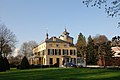
[[File:Borgharen-009.jpg|280px|right|thumb|[[Borgharen Castle]] in the town of [[Borgharen]] in the estate region.]] |
[[File:Borgharen-009.jpg|280px|right|thumb|[[Borgharen Castle]] in the town of [[Borgharen]] in the estate region.]] |
||
The '''estate region Maastricht-Meerssen''' (Dutch: ''Landgoederenzone Maastricht - Meerssen'') is the name for an area stretching from the northeastern parts of Maastricht to the south of Meerssen that is characterised by a large number of [[estate (house)|estates]]. The area is crossed by three rivers (namely the [[Meuse (river)|Meuse]], [[Geul]] and [[Kanjel]]). A majority of said estates have been built (or renovated) by the 19th century Maastrichtian industrialist [[Petrus Regout]] and his descendants. Challenges to transforming the entire region into a recreational area are posed by the crossing of the [[A2 motorway]] and various railways through the area as well as the industrial area of [[Beatrixhaven]]. |
The '''estate region Maastricht-Meerssen''' (Dutch: ''Landgoederenzone Maastricht - Meerssen'') is the name for an area stretching from the northeastern parts of Maastricht to the south of Meerssen that is characterised by a large number of [[estate (house)|estates]]. The area is crossed by three rivers (namely the [[Meuse (river)|Meuse]], [[Geul]] and [[Kanjel]]). A majority of said estates have been built (or renovated) by the 19th century Maastrichtian industrialist [[Petrus Regout]] and his descendants. Challenges to transforming the entire region into a recreational area are posed by the crossing of the [[A2 motorway (Netherlands)|A2 motorway]] and various railways through the area as well as the industrial area of [[Beatrixhaven]]. |
||
The region spans six neighbourhoods of Maastricht namely: |
The region spans six neighbourhoods of Maastricht namely: |
||
* [[Amby]]: homestead ''Withuishof'', homestead ''Gravenhof'', house ''Severen'', homestead ''Hagenhof'' (or ''Tiendschuur van Amby'') and castle ''Geuselt'' |
* [[Amby, Maastricht|Amby]]: homestead ''Withuishof'', homestead ''Gravenhof'', house ''Severen'', homestead ''Hagenhof'' (or ''Tiendschuur van Amby'') and castle ''Geuselt'' |
||
* [[Nazareth (Maastricht)|Nazareth]]: castle ''Mariënwaard'' (''La Grande Suisse''), villa ''Petite Suisse'' and villa ''Kruisdonk'' |
* [[Nazareth (Maastricht)|Nazareth]]: castle ''Mariënwaard'' (''La Grande Suisse''), villa ''Petite Suisse'' and villa ''Kruisdonk'' |
||
* [[Limmel]]: castles ''Bethlehem'' and ''Jerusalem'' |
* [[Limmel]]: castles ''Bethlehem'' and ''Jerusalem'' |
||
| Line 24: | Line 25: | ||
== Municipalities == |
== Municipalities == |
||
[[File:2012-R24-ZL-basis.jpg|280px|right|thumb|Map of South Limburg and its municipalities.]] |
[[File:2012-R24-ZL-basis.jpg|280px|right|thumb|Map of South Limburg and its municipalities.]] |
||
The South Limburg contains 18 administrative municipalities ('' |
The South Limburg contains 18 administrative municipalities (''gemeenten''): |
||
{| class="vatop" |
{| class="vatop" |
||
| |
| |
||
* [[File:Flag of Beek (Limburg).svg|25px]] [[ |
* [[File:Flag of Beek (Limburg).svg|25px]] [[Beek]] |
||
* [[File: |
* [[File:Beekdaelen_gemeentevlag.svg|25px]] [[Beekdaelen]] |
||
* [[File: |
* [[File:Brunssum vlag.svg|25px]] [[Brunssum]] |
||
* [[File: |
* [[File:Eijsden-Margraten vlag.svg|25px]] [[Eijsden-Margraten]] |
||
* [[File: |
* [[File:Gulpen-Wittem flag.svg|25px]] [[Gulpen-Wittem]] |
||
* [[File: |
* [[File:Heerlen vlag.svg|25px]] [[Heerlen]] |
||
* [[File:Flag of |
* [[File:Flag of Kerkrade.svg|25px]] [[Kerkrade]] |
||
* [[File:Flag of |
* [[File:Flag of Landgraaf.svg|25px]] [[Landgraaf]] |
||
* [[File:Flag of Meerssen.png|25px]] [[Meerssen]] |
|||
| width=25 | |
| width=25 | |
||
| |
| |
||
* [[File:Flag of |
* [[File:Flag of Maastricht.svg|25px]] [[Maastricht]] (capital of the entire [[Limburg (Netherlands)|Limburg province]]) |
||
* [[File: |
* [[File:Meerssen vlag.svg|25px]] [[Meerssen]] |
||
* [[File: |
* [[File:Simpelveld vlag.svg|25px]] [[Simpelveld]] |
||
* [[File: |
* [[File:Sittard vlag.svg|25px]] [[Sittard-Geleen]] |
||
* [[File: |
* [[File:Flag of Stein.svg|25px]] [[Stein, Limburg|Stein]] |
||
* [[File: |
* [[File:Vaals vlag.svg|25px]] [[Vaals]] |
||
* [[File:Gemeentevlag Vaals.jpg|25px]] [[Vaals]] |
|||
* [[File:Flag of Valkenburg aan de Geul.svg|25px]] [[Valkenburg aan de Geul]] |
* [[File:Flag of Valkenburg aan de Geul.svg|25px]] [[Valkenburg aan de Geul]] |
||
* [[File: |
* [[File:Voerendaal vlag.svg|25px]] [[Voerendaal]] |
||
|} |
|} |
||
| Line 61: | Line 60: | ||
|[[File:Coat of arms of Kerkrade.png|25px]] [[Kerkrade]]||47,000||Does not have historical city rights |
|[[File:Coat of arms of Kerkrade.png|25px]] [[Kerkrade]]||47,000||Does not have historical city rights |
||
|- |
|- |
||
|[[File:Sittard wapen. |
|[[File:Sittard wapen.svg|25px]] [[Sittard]]||38,000 |
||
|- |
|- |
||
|[[File:Wapen Geleen Oud.JPG|25px]] [[Geleen]]||32,000 |
|[[File:Wapen Geleen Oud.JPG|25px]] [[Geleen]]||32,000 |
||
| Line 67: | Line 66: | ||
|[[File:Coat of arms of Stein.png|25px]] [[Stein, Limburg|Stein]]||26,000|| Does not have historical city rights |
|[[File:Coat of arms of Stein.png|25px]] [[Stein, Limburg|Stein]]||26,000|| Does not have historical city rights |
||
|- |
|- |
||
|[[File:Valkenburg |
|[[File:Valkenburg aan de Geul wapen.svg|25px]] [[Valkenburg (city)|Valkenburg]]||6,000 |
||
|} |
|} |
||
| Line 90: | Line 89: | ||
File:Severen-001.jpg|''Estate region'': Homestead Severen |
File:Severen-001.jpg|''Estate region'': Homestead Severen |
||
</gallery> |
</gallery> |
||
== See also == |
|||
* [[South Limburg (Belgium)]], region in the southern part of the Belgian province of [[Limburg (Belgium)|Limburg]] |
|||
==External links== |
==External links== |
||
{{wikivoyage|South Limburg}} |
|||
*[http://www.gomv.nl/menu2/landgoederenzone/poster%20toekomstbeeld%20landgoederenzone%2012%20feb%20a2.jpg Vision on the future of the estate region (Dutch)] |
*[https://web.archive.org/web/20110724152459/http://www.gomv.nl/menu2/landgoederenzone/poster%20toekomstbeeld%20landgoederenzone%2012%20feb%20a2.jpg Vision on the future of the estate region (Dutch)] |
||
*[http://www.wigosite.nl/Maastrichtkastelenpagina/Maastrichtkastelen.htm The estate region on wigosite.nl (Dutch)] |
*[http://www.wigosite.nl/Maastrichtkastelenpagina/Maastrichtkastelen.htm The estate region on wigosite.nl (Dutch)] |
||
*[http://www.zichtopmaastricht.nl/sources/articles/The%20Regout%20estates.pdf The Regout estates (English)] |
*[http://www.zichtopmaastricht.nl/sources/articles/The%20Regout%20estates.pdf The Regout estates (English)] |
||
| Line 98: | Line 101: | ||
{{coord missing|Netherlands}} |
{{coord missing|Netherlands}} |
||
[[Category: |
[[Category:South Limburg (Netherlands)| ]] |
||
[[Category:Regions of Limburg (Netherlands)]] |
|||
[[Category:Regions of the Netherlands]] |
[[Category:Regions of the Netherlands]] |
||
[[ca:Limburg meridional]] |
|||
[[de:Zuid-Limburg]] |
|||
[[nl:Zuid-Limburg (Nederland)]] |
|||
Latest revision as of 23:47, 25 December 2023

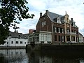
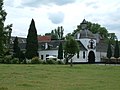
South Limburg (Dutch: Zuid-Limburg, Limburgish: Zuud-Limburg) is both a COROP (statistical) region as well as a landstreek (area) of the Netherlands located in the province of Limburg. The Dutch term landstreek, literally translated "land area/region", means that the area is not an administrative region but an area that displays cohesion with regard to culture and landscape. With regards to South Limburg this deals with its hilly landscape, especially in the Heuvelland region, sunken lanes, an abundance of castles, and the regional language Limburgish spoken by a significant part of the population alongside Dutch. The region also contains the highest point above sea level in mainland Netherlands, the Vaalserberg being 322.5 metres (1,058 ft) above sea level (the highest point of the entire country is in the Caribbean Netherlands' island of Saba, namely Mount Scenery being 887 metres (2,910 ft) above sea level).
The region South Limburg in addition, although extended a little further north to Roermond, forms a constituent part of the Euroregion Meuse-Rhine.
Estate region Maastricht-Meerssen
[edit]
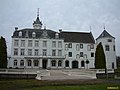
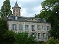
The estate region Maastricht-Meerssen (Dutch: Landgoederenzone Maastricht - Meerssen) is the name for an area stretching from the northeastern parts of Maastricht to the south of Meerssen that is characterised by a large number of estates. The area is crossed by three rivers (namely the Meuse, Geul and Kanjel). A majority of said estates have been built (or renovated) by the 19th century Maastrichtian industrialist Petrus Regout and his descendants. Challenges to transforming the entire region into a recreational area are posed by the crossing of the A2 motorway and various railways through the area as well as the industrial area of Beatrixhaven.
The region spans six neighbourhoods of Maastricht namely:
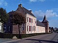
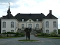
- Amby: homestead Withuishof, homestead Gravenhof, house Severen, homestead Hagenhof (or Tiendschuur van Amby) and castle Geuselt
- Nazareth: castle Mariënwaard (La Grande Suisse), villa Petite Suisse and villa Kruisdonk
- Limmel: castles Bethlehem and Jerusalem
- Meerssenhoven: castles Vaeeshartelt and Meerssenhoven and villa Klein Vaeshartelt
- Itteren*: homestead Hartelstein
- Borgharen*: Borgharen castle and homestead Wiegershof
(* some publications do not include Itteren and Borgharen in the estate region)
And in Meerssen:
Municipalities
[edit]
The South Limburg contains 18 administrative municipalities (gemeenten):
|
Cities
[edit]| Name | Population 2011/2012 |
Notes |
| 121,000 | ||
| 89,000 | Does not have historical city rights | |
| 47,000 | Does not have historical city rights | |
| 38,000 | ||
| 32,000 | ||
| 26,000 | Does not have historical city rights | |
| 6,000 |
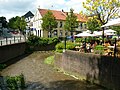
Impressions of South Limburg
[edit]-
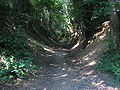 A sunken lane near Cadier en Keer
 -
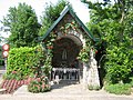 Chapel near Cadier en Keer
 -
 Town of Eys
 -
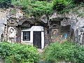 "Rock house" near Geulhem
 -
 Town of Gulpen
 -
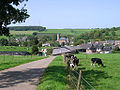
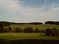 Hilly landscape between Gulpen and Slenaken
 -
 Onze-Lieve-Vrouwe-Embankment, Maastricht
 -
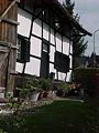 Timber framed house in Noorbeek
 -
 't Sibberhuuske, Sibbe
 -
 Estate region: Vaeshartelt Castle, Meerssen
 -
 Estate region: Meerssenhoven
 -
 Estate region: Villa Kruisdonk
 -
 Estate region: Bethlehem Castle
 -
 Estate region: Jerusalem Castle
 -
 Estate region: Villa Severen
 -
 Estate region: Homestead Severen


See also
[edit]- South Limburg (Belgium), region in the southern part of the Belgian province of Limburg
External links
[edit]- Vision on the future of the estate region (Dutch)
- The estate region on wigosite.nl (Dutch)
- The Regout estates (English)