
Glymur: Difference between revisions
m Bot: Migrating 17 interwiki links, now provided by Wikidata on d:q38577 (Report Errors) |
No edit summary |
||
| (42 intermediate revisions by 27 users not shown) | |||
| Line 1: | Line 1: | ||
{{Short description|Waterfall in Iceland}} |
|||
{{Use dmy dates|date=July 2023}} |
|||
{{Infobox waterfall |
{{Infobox waterfall |
||
| name = Glymur |
| name = Glymur |
||
| photo = glymur.jpg |
| photo = glymur.jpg |
||
| photo_caption = |
| photo_caption = |
||
| location = Iceland |
| location = [[Hvalfjarðarsveit]], [[Vesturland]], Iceland |
||
| type = Horsetail |
| type = Horsetail |
||
| map = Iceland |
|||
| height = {{Convert|198|m|ft|0|abbr=on}} |
| height = {{Convert|198|m|ft|0|abbr=on}} |
||
| number_drops = 1 |
| number_drops = 1 |
||
| Line 10: | Line 13: | ||
| coords = {{coord|64|23|45|N|21|14|28|W}} |
| coords = {{coord|64|23|45|N|21|14|28|W}} |
||
}} |
}} |
||
The [[waterfall]] '''Glymur''', with a cascade of 196 m, is the highest waterfall of [[Iceland]]. |
|||
'''Glymur''' ({{IPA-is|ˈklɪːmʏr̥|3=Glymur pronunciation.ogg}}) is a [[waterfall]] in [[Hvalfjarðarsveit]], [[Vesturland]], Iceland. It is the second-tallest in the country with a cascade of {{convert|198|m}}. Glymur was long regarded as the tallest until being surpassed by [[Morsárfoss]], a newly measured waterfall near Morsárjökull in 2011.<ref>{{cite news|last1=Guðmundsson|first1=Janus Arn|title=Flyst hæsti foss landsins búferlum?|url=http://www.mbl.is/frettir/innlent/2011/06/15/flyst_haesti_foss_landsins_buferlum/|access-date=1 August 2015|agency=Morgunblaðið|date=2011-06-15|language=Icelandic}}</ref> |
|||
| ⚫ | |||
| ⚫ | |||
The river Botnsá leaves the lake [[Hvalvatn]] and after a short distance the water falls down alongside the volcano ''Hvalfell'' into a canyon with green moss. The waterfall can be accessed from Botnsá, a small village of summerhouses named after the river. From the Botnsá parking area, one can hike up part of the mountain (350 m) on marked hiking paths. To get a better view of the waterfall it is necessary to see it from the south side of the river Botnsá, however the south side trail is strenuous and potentially hazardous, passing along the edges of steep dropoffs. |
|||
The river [[Botnsá]] {{IPA-is|ˈpɔsːˌauː|}} runs from the [[Hvalvatn]] lake and after a short distance the water falls down alongside the Hvalfell mountain into a steep canyon. The waterfall can be accessed from a parking area at the end of the road. Hikers can view the waterfall from marked paths on the east side of the river Botnsá. |
|||
From the parking area, both trails begin by passing through a gate and walking up a dirt road. The easier north side trail continues up the dirt road and is marked by rocks blazed with yellow paint. A few hundred meters up the road, the south side trail (also marked by yellow rocks) branches off to the right. This drops over a small cliff face and descends through a cave down to the river. In the summer there is a small pole over the river with an adjacent cable for a handhold, where travelers can cross to the southern side. |
|||
==Gallery== |
|||
After crossing the river, the south trail climbs steeply with various muddy, rocky and loose areas. At times it skirts steep dropoffs. About 3/4 way up this trail passes a small side waterfall with a sheltered pool. Hikers often stop here to refresh themselves; this point is a milestone only a short distance below the viewing area. Anyone attempting this trail should have proper boots, water, and preferably hiking poles though many people hike without poles. The south trail is a strenuous but non-technical climb rather than a mere walk. |
|||
<gallery mode='packed'> |
|||
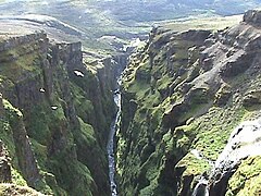
Glymurschlucht.JPG|Downstream view of the canyon |
|||
It is also possible to reach the base of the falls, but only by wading through the Botnsá. There are strong winds and serious risks of rockfall in the narrow canyon bottom. |
|||
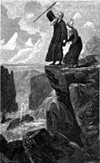
Rauðhöfði.jpg|Legend of Rauðhöfði |
|||
</gallery> |
|||
The second picture is an engraving showing people trying to escape from a monster whale. It is an illustration of the Icelandic legend of Redhead (Rauðhöfði {{IPA-is|ˈrœyðˌhœvðɪ|}}) which is said to be the cause of the formation of Glymur. |
|||
==See also== |
==See also== |
||
* [[List of waterfalls]] |
* [[List of waterfalls]] |
||
* [[Waterfalls of Iceland]] |
* [[Waterfalls of Iceland]] |
||
==References== |
|||
{{Reflist}} |
|||
==External links== |
==External links== |
||
{{Commons}} |
|||
*[ |
*[https://web.archive.org/web/20191202121200/https://www.nat.is/travelguideeng/plofin_glymur_waterfall.htm Information] |
||
*[http://eik.klaki.net/haf/02sept14/20020914_141120.jpg Photo] |
|||
*[http://site.voila.fr/gonguferdir/glymur.html Photos] |
|||
| ⚫ | |||
{{Waterfalls of Iceland}} |
{{Waterfalls of Iceland}} |
||
{{Authority control}} |
|||
[[Category:Waterfalls of Iceland]] |
|||
[[ro:Glymur]] |
|||
| ⚫ | |||
Latest revision as of 01:08, 28 October 2023
| Glymur | |
|---|---|
 | |
 | |
 | |
| Location | Hvalfjarðarsveit, Vesturland, Iceland |
| Coordinates | 64°23′45″N 21°14′28″W / 64.39583°N 21.24111°W |
| Type | Horsetail |
| Total height | 198 m (650 ft) |
| Number of drops | 1 |
Glymur (Icelandic pronunciation: [ˈklɪːmʏr̥] ) is a waterfall in Hvalfjarðarsveit, Vesturland, Iceland. It is the second-tallest in the country with a cascade of 198 metres (650 ft). Glymur was long regarded as the tallest until being surpassed by Morsárfoss, a newly measured waterfall near Morsárjökull in 2011.[1]
It is situated at the rear end of the Hvalfjörður. Since the opening of the Hvalfjörður Tunnel under this fjord, visitor numbers have dropped.[citation needed]
The river Botnsá [ˈpɔsːˌauː] runs from the Hvalvatn lake and after a short distance the water falls down alongside the Hvalfell mountain into a steep canyon. The waterfall can be accessed from a parking area at the end of the road. Hikers can view the waterfall from marked paths on the east side of the river Botnsá.
Gallery
[edit]-
 Downstream view of the canyon
 -
 Legend of Rauðhöfði


The second picture is an engraving showing people trying to escape from a monster whale. It is an illustration of the Icelandic legend of Redhead (Rauðhöfði [ˈrœyðˌhœvðɪ]) which is said to be the cause of the formation of Glymur.
See also
[edit]References
[edit]- ^ Guðmundsson, Janus Arn (15 June 2011). "Flyst hæsti foss landsins búferlum?" (in Icelandic). Morgunblaðið. Retrieved 1 August 2015.
External links
[edit]| International | |
|---|---|
| Geographic | |
This Iceland location article is a stub. You can help Wikipedia by expanding it. |