
Damme: Difference between revisions
m changed hat note |
|||
| (36 intermediate revisions by 26 users not shown) | |||
| Line 1: | Line 1: | ||
{{Short description|Municipality in Flemish Community, Belgium}} |
|||
{{about|the town in Belgium|the town in Germany|Damme (Dümmer)}} |
|||
{{Other}} |
|||
{{Infobox Belgium |
{{Infobox Belgium municipality |
||
| ⚫ | |||
|name = Damme |
|||
| ⚫ | |||
|type = city |
|||
|picture-legend=Damme Town Hall |
|||
| ⚫ | |||
|map=DammeLocatie.png |
|||
| |
|picture-legend = Damme Town Hall |
||
|map = Damme West-Flanders Belgium Map.svg |
|||
|arms=Dammewapen.jpg |
|||
|map-legend = Location of Damme in [[West Flanders]] |
|||
|flag=Dammevlag.jpg |
|||
|arms = Blason Damme.svg |
|||
|region={{BE-REG-FLE}} |
|||
|flag = Damme vlag.svg |
|||
| ⚫ | |||
| |
|region = {{BE-REG-FLE}} |
||
| ⚫ | |||
| ⚫ | |||
|province = {{BE-PROV-WV}} |
|||
|nis=31006 |
|||
| ⚫ | |||
| ⚫ | |||
|nis = 31006 |
|||
| ⚫ | |||
|0-19=22.89 |
|0-19=22.89 |
||
|20-64=58.70 |
|20-64=58.70 |
||
|65=18.41 |
|65=18.41 |
||
|foreigners=1.47 |
|foreigners=1.47 |
||
|foreigners-date=01/07/2005 |
|foreigners-date = 01/07/2005 |
||
|mayor= |
|mayor = [[Joachim Coens]] ([[Christen-Democratisch en Vlaams|CD&V]]) |
||
|majority=[[Christen-Democratisch en Vlaams|CD&V]] |
|majority = [[Christen-Democratisch en Vlaams|CD&V]] |
||
|postal-codes=8340 |
|postal-codes = 8340 |
||
|telephone-area=050 |
|telephone-area = 050 |
||
|web=[http://www.damme.be/ www.damme.be] |
|web = [http://www.damme.be/ www.damme.be] |
||
|coordinates = {{coord|51|15|N|03|16|E|region:BE|display=inline,title}} |
|||
|lat_deg=51 |
|||
|lat_min=15 |
|||
|lon_deg=03 |
|||
|lon_min=16 |
|||
}} |
}} |
||
'''Damme''' ({{IPA-nl| |
'''Damme''' ({{IPA-nl|ˈdɑmə|-|Nl-Damme.ogg}}) is a [[City status in Belgium|city]] and [[Municipalities of Belgium|municipality]] located in the [[Belgium|Belgian]] province of [[West Flanders]], six kilometres northeast of Brugge ([[Bruges]]). The municipality comprises the city of Damme proper and the villages of [[Hoeke]], [[Lapscheure]], [[Moerkerke]], [[Oostkerke (Damme)|Oostkerke]], [[Sijsele]], {{Interlanguage link multi|Vivenkapelle|nl}}, and {{Interlanguage link multi|Sint-Rita|nl}}. On 1 January 2006, the municipality had a population of 10,899. The total area is 89.52 km<sup>2</sup>, giving a [[population density]] of 122 inhabitants per km<sup>2</sup>. |
||
[[Image:DammeChurch.JPG|thumb|left|160px|Damme church]] |
|||
==History== |
|||
In the 13th century, Damme was the |
In the 13th century, Damme was one of the major ports of Europe and the outlet to the sea for the major trading city of Bruges, to which it was linked by the river Reie. The river has now been [[Ship canal|canalised]] into the long, straight, treelined and picturesque Damse Vaart, which continues across the Dutch border to [[Sluis]]. The line of the town's star-shaped fortifications can still be traced by lines of tall poplar trees and in places by a moat. It was the site of the [[Battle of Damme]], fought on 30 and 31 May 1213, when an English fleet under the Earl of Salisbury captured scores of French ships and their cargo of gold, silver, wine, bacon and other victuals.{{sfn|Chisholm|1911b|p=789}} |
||
Well-known Damme inhabitants include [[Jacob van Maerlant]], a medieval poet and the town clerk of Damme until his death in around 1300, and [[Karel Verleye]], co-founder of the [[Bruges]] [[College of Europe]], who died in Damme in 2002. |
Well-known Damme inhabitants include [[Jacob van Maerlant]], a medieval poet and the town clerk of Damme until his death in around 1300, and [[Karel Verleye]], co-founder of the [[Bruges]] [[College of Europe]], who died in Damme in 2002. |
||
== |
== Tourism == |
||
Today, Damme is a popular side trip for tourists who are visiting Bruges and is a popular venue for eating out, and a destination for boat trips. Damme has more recently become known as a [[book town]], with numerous bookshops and regular book fairs. |
Today, Damme is a popular side trip for tourists who are visiting Bruges and is a popular venue for eating out, and a destination for boat trips. Damme has more recently become known as a [[book town]], with numerous bookshops and regular book fairs. |
||
The most popular ways of |
The most popular ways of traveling to Damme are by canal boat that runs during the summer high season or all year round by bus or bicycle. The bicycle route is along the canal path taking the same route that the canal boat takes. |
||
==Maps== |
==Maps== |
||
| Line 49: | Line 49: | ||
==References== |
==References== |
||
{{ |
{{Reflist}} |
||
==Sources== |
|||
* {{cite EB1911|last=Chisholm|first=Hugh|wstitle=Damme|date=1911b|volume=7|page=789}} {{OCLC|221022251}} |
|||
==External links== |
==External links== |
||
| ⚫ | |||
| ⚫ | |||
{{Wikivoyage}} |
*{{Wikivoyage-inline}} |
||
| ⚫ | |||
{{Geographic location |
|||
| ⚫ | |||
| ⚫ | |||
|N = [[Knokke-Heist]] |
|||
|NE = [[Sluis]] ([[Netherlands|NL]]-[[Zeeland|ZE]]) |
|||
|E = [[Maldegem]] ([[East Flanders|VOV]]) |
|||
|S = [[Beernem]] |
|||
|W = [[Bruges]] |
|||
}} |
|||
{{Hanseatic League}} |
{{Hanseatic League}} |
||
{{West Flanders}} |
{{Municipalities in West Flanders}} |
||
{{Authority control}} |
|||
| ⚫ | |||
[[Category:Municipalities of West Flanders]] |
[[Category:Municipalities of West Flanders]] |
||
[[Category:Populated places in Belgium]] |
|||
| ⚫ | |||
Latest revision as of 15:55, 29 September 2023
Damme | |
|---|---|
City and municipality | |
.JPG) Damme Town Hall | |
 Flag  Coat of arms | |
Location of Damme  | |
 Damme Location in Belgium
Location of Damme in West Flanders  | |
| Coordinates: 51°15′N 03°16′E / 51.250°N 3.267°E | |
| Country | |
| Community | Flemish Community |
| Region | Flemish Region |
| Province | West Flanders |
| Arrondissement | Bruges |
| Government | |
| • Mayor | Joachim Coens (CD&V) |
| • Governing party/ies | CD&V |
| Area | |
| • Total | 90.36 km2 (34.89 sq mi) |
| Population (2018-01-01)[1] | |
| • Total | 11,008 |
| • Density | 120/km2 (320/sq mi) |
| Postal codes | 8340 |
| NIS code | 31006 |
| Area codes | 050 |
| Website | www.damme.be |
Damme (Dutch pronunciation: [ˈdɑmə] ) is a city and municipality located in the Belgian province of West Flanders, six kilometres northeast of Brugge (Bruges). The municipality comprises the city of Damme proper and the villages of Hoeke, Lapscheure, Moerkerke, Oostkerke, Sijsele, Vivenkapelle, and Sint-Rita. On 1 January 2006, the municipality had a population of 10,899. The total area is 89.52 km2, giving a population density of 122 inhabitants per km2.
History
[edit]In the 13th century, Damme was one of the major ports of Europe and the outlet to the sea for the major trading city of Bruges, to which it was linked by the river Reie. The river has now been canalised into the long, straight, treelined and picturesque Damse Vaart, which continues across the Dutch border to Sluis. The line of the town's star-shaped fortifications can still be traced by lines of tall poplar trees and in places by a moat. It was the site of the Battle of Damme, fought on 30 and 31 May 1213, when an English fleet under the Earl of Salisbury captured scores of French ships and their cargo of gold, silver, wine, bacon and other victuals.[2]
Well-known Damme inhabitants include Jacob van Maerlant, a medieval poet and the town clerk of Damme until his death in around 1300, and Karel Verleye, co-founder of the Bruges College of Europe, who died in Damme in 2002.
Tourism
[edit]Today, Damme is a popular side trip for tourists who are visiting Bruges and is a popular venue for eating out, and a destination for boat trips. Damme has more recently become known as a book town, with numerous bookshops and regular book fairs.
The most popular ways of traveling to Damme are by canal boat that runs during the summer high season or all year round by bus or bicycle. The bicycle route is along the canal path taking the same route that the canal boat takes.
Maps
[edit]-
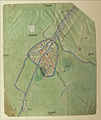 Damme on the Deventer map (around 1558)
 -
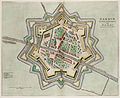 Damme on the Atlas van Loon (around 1649)
 -
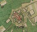 Damme on the Ferraris map (around 1775)

.jpg)

References
[edit]- ^ "Wettelijke Bevolking per gemeente op 1 januari 2018". Statbel. Retrieved 9 March 2019.
- ^ Chisholm 1911b, p. 789.
Sources
[edit]- Chisholm, Hugh (1911b). . In Chisholm, Hugh (ed.). Encyclopædia Britannica. Vol. 7 (11th ed.). Cambridge University Press. p. 789. OCLC 221022251
External links
[edit] Media related to Damme at Wikimedia Commons
 Damme travel guide from Wikivoyage
- Official website
Members of the Hanseatic League by quarter, and trading posts of the Hanseatic League | ||||
|---|---|---|---|---|
| ||||
| Wendish |
|   | ||
| Saxon | ||||
| Baltic | ||||
| Westphalian | ||||
| Kontore | ||||
| Vitten | ||||
| Factories | ||||
| Bruges |  | |
|---|---|---|
| Diksmuide | ||
| Kortrijk | ||
| Ostend | ||
| Roeselare | ||
| Tielt | ||
| Veurne | ||
| Ypres | ||
| ||
| International | |
|---|---|
| National | |
| Geographic | |