
Wallis, Texas: Difference between revisions
→top: add "use mdy dates" template |
|||
| (31 intermediate revisions by 24 users not shown) | |||
| Line 1: | Line 1: | ||
{{Use mdy dates|date=July 2023}} |
|||
{{Infobox settlement |
{{Infobox settlement |
||
|official_name = Wallis, Texas |
| official_name = Wallis, Texas |
||
|settlement_type = [[City]] |
| settlement_type = [[City]] |
||
|nickname = |
| nickname = |
||
|motto = |
| motto = <!-- Images --> |
||
| image_skyline = File:Downtown Wallis Texas WS (1 of 1).jpg |
|||
| imagesize = 280px |
|||
| image_caption = View of Wallis along Highway 36 in 2020 |
|||
| image_flag = |
|||
| image_seal = <!-- Maps --> |
|||
| image_map = TXMap-doton-Wallis.PNG |
|||
| mapsize = 250px |
|||
| map_caption = Location of Wallis, Texas |
|||
| image_map1 = Austin Wallis.svg |
|||
| mapsize1 = 250px |
|||
| map_caption1 = <!-- Location --> |
|||
| subdivision_type = [[List of sovereign states|Country]] |
|||
| subdivision_name = United States |
|||
| subdivision_type1 = [[U.S. state|State]] |
|||
| subdivision_name1 = [[Texas]] |
|||
| subdivision_type2 = [[List of counties in Texas|County]] |
|||
| subdivision_name2 = [[Austin County, Texas|Austin]] |
|||
<!-- Government -->| government_footnotes = |
|||
<!-- Images --> |
|||
| |
| government_type = |
||
| |
| leader_title = |
||
| |
| leader_name = |
||
| |
| leader_title1 = |
||
| |
| leader_name1 = |
||
| established_title = |
|||
| established_date = <!-- Area --> |
|||
| unit_pref = Imperial |
|||
| area_footnotes = <ref name="CenPopGazetteer2019">{{cite web|title=2019 U.S. Gazetteer Files|url=https://www2.census.gov/geo/docs/maps-data/data/gazetteer/2019_Gazetteer/2019_gaz_place_48.txt|publisher=United States Census Bureau|accessdate=August 7, 2020}}</ref> |
|||
| area_magnitude = |
|||
| area_total_km2 = 3.91 |
|||
| area_land_km2 = 3.87 |
|||
| area_water_km2 = 0.04 |
|||
| area_total_sq_mi = 1.51 |
|||
| area_land_sq_mi = 1.50 |
|||
| area_water_sq_mi = 0.01 |
|||
<!-- Population -->| population_as_of = [[2020 United States Census|2020]] |
|||
<!-- Maps --> |
|||
| population_footnotes = |
|||
|image_map = TXMap-doton-Wallis.PNG |
|||
| |
| population_total = 1292 |
||
| population_density_km2 = 336.42 |
|||
|map_caption = Location of Wallis, Texas |
|||
|image_map1 = Austin Wallis.svg |
|||
|mapsize1 = 250px |
|||
|map_caption1 = |
|||
<!-- General information -->| timezone = [[North American Central Time Zone|Central (CST)]] |
|||
<!-- Location --> |
|||
| utc_offset = -6 |
|||
|subdivision_type = [[List of countries|Country]] |
|||
| |
| timezone_DST = CDT |
||
| utc_offset_DST = -5 |
|||
|subdivision_type1 = [[Political divisions of the United States|State]] |
|||
| elevation_footnotes = |
|||
|subdivision_name1 = [[Texas]] |
|||
| elevation_m = 39 |
|||
|subdivision_type2 = [[List of counties in Texas|County]] |
|||
| elevation_ft = 128 |
|||
|subdivision_name2 = [[Austin County, Texas|Austin]] |
|||
| coordinates = {{coord|29|37|50|N|96|3|46|W|region:US_type:city|display=inline,title}} |
|||
| postal_code_type = [[ZIP code]] |
|||
<!-- Government --> |
|||
| |
| postal_code = 77485 |
||
| |
| area_code = [[Area code 979|979]] |
||
| blank_name = [[Federal Information Processing Standard|FIPS code]] |
|||
|leader_title = |
|||
| blank_info = 48-76240<ref name="GR2">{{cite web|url=https://www.census.gov|publisher=[[United States Census Bureau]]|accessdate=2008-01-31|title=U.S. Census website}}</ref> |
|||
|leader_name = |
|||
| blank1_name = [[Geographic Names Information System|GNIS]] feature ID |
|||
|leader_title1 = |
|||
| blank1_info = 1376626<ref name="GR3">{{cite web|url=http://geonames.usgs.gov|accessdate=2008-01-31|title=US Board on Geographic Names|publisher=[[United States Geological Survey]]|date=2007-10-25}}</ref> |
|||
|leader_name1 = |
|||
| website = {{URL|www.wallistexas.org}} |
|||
|established_title = |
|||
| |
| footnotes = |
||
| population_density_sq_mi = 871.57 |
|||
<!-- Area --> |
|||
|unit_pref = Imperial |
|||
|area_footnotes = |
|||
|area_magnitude = |
|||
|area_total_km2 = 3.9 |
|||
|area_land_km2 = 3.9 |
|||
|area_water_km2 = 0.0 |
|||
|area_total_sq_mi = |
|||
|area_land_sq_mi = |
|||
|area_water_sq_mi = |
|||
<!-- Population --> |
|||
|population_as_of = [[2010 United States Census|2010]] |
|||
|population_footnotes = |
|||
|population_total = 1252 |
|||
|population_density_km2 = 323.2 |
|||
|population_density_sq_mi = |
|||
<!-- General information --> |
|||
|timezone = [[North American Central Time Zone|Central (CST)]] |
|||
|utc_offset = -6 |
|||
|timezone_DST = CDT |
|||
|utc_offset_DST = -5 |
|||
|elevation_footnotes = |
|||
|elevation_m = 39 |
|||
|elevation_ft = 128 |
|||
|coordinates_display = inline,title |
|||
|coordinates_type = region:US_type:city |
|||
|latd = 29 |latm = 37 |lats = 50 |latNS = N |
|||
|longd = 96 |longm = 3 |longs = 46 |longEW = W |
|||
<!-- Area/postal codes & others --> |
|||
|postal_code_type = [[ZIP code]] |
|||
|postal_code = 77485 |
|||
|area_code = [[Area code 979|979]] |
|||
|blank_name = [[Federal Information Processing Standard|FIPS code]] |
|||
|blank_info = 48-76240<ref name="GR2">{{cite web|url=http://factfinder2.census.gov|publisher=[[United States Census Bureau]]|accessdate=2008-01-31|title=American FactFinder}}</ref> |
|||
|blank1_name = [[Geographic Names Information System|GNIS]] feature ID |
|||
|blank1_info = 1376626<ref name="GR3">{{cite web|url=http://geonames.usgs.gov|accessdate=2008-01-31|title=US Board on Geographic Names|publisher=[[United States Geological Survey]]|date=2007-10-25}}</ref> |
|||
|website = {{URL|www.wallistexas.org}} |
|||
|footnotes = |
|||
}} |
}} |
||
'''Wallis''' is a city in far southeastern [[Austin County, Texas|Austin County]], [[Texas]], |
'''Wallis''' is a city in far southeastern [[Austin County, Texas|Austin County]], [[Texas]], United States. The city is located along [[Texas State Highway 36|State Highway 36]] (SH 36) and the [[BNSF Railway]] between [[Rosenberg, Texas|Rosenberg]] and [[Sealy, Texas|Sealy]]. The city's population was 1,292 at the [[2020 United States census|2020 census]].<ref name="Census 2010">{{cite web| url=http://factfinder.census.gov/bkmk/table/1.0/en/DEC/10_DP/G001/1600000US4876240| archive-url=https://archive.today/20200210220633/http://factfinder.census.gov/bkmk/table/1.0/en/DEC/10_DP/G001/1600000US4876240| url-status=dead| archive-date=February 10, 2020| title=Geographic Identifiers: 2010 Demographic Profile Data (G001): Wallis city, Texas| publisher=U.S. Census Bureau, American Factfinder| accessdate=August 26, 2013}}</ref> |
||
==Geography== |
==Geography== |
||
Wallis is located at {{coord|29|37|50|N|96|3|46|W|type:city}} (29.630649, -96.062751).<ref name="GR1">{{cite web|url=http://www.census.gov/geo/www/gazetteer/gazette.html|publisher=[[United States Census Bureau]]|accessdate=2011-04-23|date=2011-02-12|title=US Gazetteer files: 2010, 2000, and 1990}}</ref> SH 36 heads northwest from Wallis to Sealy in Austin County and east-southeast from Wallis to Rosenberg in [[Fort Bend County, Texas|Fort Bend County]]. The BNSF Railway runs parallel with SH 36 on the north side of the highway. [[Texas State Highway 60|State Highway 60]] starts in the west part of Wallis and goes south to [[East Bernard, Texas|East Bernard]]. [[Farm to Market Road 1093]] continues northeast to [[Simonton, Texas|Simonton]] in Fort Bend County and west-southwest to [[Eagle Lake, Texas|Eagle Lake]] in [[Colorado County, Texas|Colorado County]]. [[Farm to Market Road 1952]] begins in the east part of Wallis and goes south and east to [[Tavener, Texas|Tavener]] in Fort Bend County. The [[Google Maps]] service shows one [[Catholic Church in the United States|Catholic]], two [[Lutheranism|Lutheran]] and one [[Baptists in the United States|Baptist]] churches in Wallis. A number of businesses operate in the city including Wallis State Bank and City Food Mart.<ref name=maps>{{google maps|url=https://maps.google.com/maps?q=Wallis,+TX&hl=en&sll=31.168934,-100.076842&sspn=13.684125,20.324707&hnear=Wallis,+Austin,+Texas&t=m&z=14 |accessdate=June 2, 2013}}</ref> |
|||
Wallis is located at {{coord|29|37|50|N|96|3|46|W|type:city}} (29.630649, –96.062751).<ref name="GR1">{{cite web|url=https://www.census.gov/geographies/reference-files/time-series/geo/gazetteer-files.html|publisher=[[United States Census Bureau]]|accessdate=2011-04-23|date=2011-02-12|title=US Gazetteer files: 2010, 2000, and 1990}}</ref> SH 36 heads northwest from Wallis to Sealy in Austin County and east-southeast from Wallis to Rosenberg in [[Fort Bend County, Texas|Fort Bend County]]. The BNSF Railway runs parallel with SH 36 on the north side of the highway. [[Texas State Highway 60|State Highway 60]] starts in the west part of Wallis and goes south to [[East Bernard, Texas|East Bernard]]. [[Farm to Market Road 1093]] continues northeast to [[Simonton, Texas|Simonton]] in Fort Bend County and west-southwest to [[Eagle Lake, Texas|Eagle Lake]] in [[Colorado County, Texas|Colorado County]]. [[Farm to Market Road 1952]] begins in the east part of Wallis and goes south and east to [[Tavener, Texas|Tavener]] in Fort Bend County. |
|||
According to the [[United States Census Bureau]], the city has a total area of {{convert|3.9|km2|disp=flip}}, of which {{convert|0.04|sqkm|disp=flip|3}}, or 0.92%, is water.<ref name="Census 2010"/> |
According to the [[United States Census Bureau]], the city has a total area of {{convert|3.9|km2|disp=flip}}, of which {{convert|0.04|sqkm|disp=flip|3}}, or 0.92%, is water.<ref name="Census 2010"/> |
||
==History== |
==History== |
||
In 1830 the first Anglo-Americans made their homes in the area between the [[Brazos River|Brazos]] and [[San Bernard River|San Bernard]] rivers. When the settlement got a post office in 1873, its name was Bovine Bend. Sometime after 1880, the [[Gulf, Colorado and Santa Fe Railway]] was constructed through the community from [[Galveston, Texas|Galveston]] to [[Brenham, Texas|Brenham]]. At that time, the town was renamed Wallis Station after J. E. Wallis, the director of the railroad. In 1887 the [[San Antonio and Aransas Pass Railway]], being built east toward [[Houston]], reached Wallis. Starting in about 1890, [[Czechs|Czech]] immigrants began moving into the area. By 1904 there were 631 souls living in Wallis. In 1911, the town dropped "Station" from its name to become Wallis. Seven years later its school had 100 students. Between 1925 and 1943 the population grew from 800 to 900. By the latter year the town boasted 39 businesses. After declining to 690 in 1949, the number of inhabitants increased to 1,075 by 1966. A decade later, the city claimed to have a bank, library, and a newspaper, as well as two schools and eight churches. In 1991 there were 1,411 people and 15 commercial establishments. The population declined to 1,311 in 2000<ref>{{cite web|last=Jackson |first=Charles Christopher |title=Handbook of Texas Online: WALLIS, TX |publisher=Texas State Historical Association |url= |
In 1830 the first Anglo-Americans made their homes in the area between the [[Brazos River|Brazos]] and [[San Bernard River|San Bernard]] rivers. When the settlement got a post office in 1873, its name was Bovine Bend. Sometime after 1880, the [[Gulf, Colorado and Santa Fe Railway]] was constructed through the community from [[Galveston, Texas|Galveston]] to [[Brenham, Texas|Brenham]]. At that time, the town was renamed Wallis Station after J. E. Wallis, the director of the railroad. In 1887 the [[San Antonio and Aransas Pass Railway]], being built east toward [[Houston]], reached Wallis. Starting in about 1890, [[Czechs|Czech]] immigrants began moving into the area. By 1904 there were 631 souls living in Wallis. In 1911, the town dropped "Station" from its name to become Wallis. Seven years later its school had 100 students. Between 1925 and 1943 the population grew from 800 to 900. By the latter year the town boasted 39 businesses. After declining to 690 in 1949, the number of inhabitants increased to 1,075 by 1966. A decade later, the city claimed to have a bank, library, and a newspaper, as well as two schools and eight churches. In 1991 there were 1,411 people and 15 commercial establishments. The population declined to 1,311 in 2000<ref>{{cite web|last=Jackson |first=Charles Christopher |title=Handbook of Texas Online: WALLIS, TX |publisher=Texas State Historical Association |url=https://tshaonline.org/handbook/online/articles/hjw02 |accessdate=June 2, 2013}}</ref> and to 1,252 in 2010. In 2013 the BNSF Railway still operated along the one-time Gulf, Colorado and Santa Fe Railway right-of-way, while the east–west railroad line no longer existed.<ref name=maps>{{google maps|url=https://maps.google.com/maps?q=Wallis,+TX&hl=en&sll=31.168934,-100.076842&sspn=13.684125,20.324707&hnear=Wallis,+Austin,+Texas&t=m&z=14 |accessdate=June 2, 2013}}</ref> |
||
<gallery widths="300px" heights="225px" |
<gallery widths="300px" heights="225px"> |
||
File:Wallis TX |
File:Wallis TX Guardian Angel Church.JPG|[[Church of the Guardian Angel|Guardian Angel Catholic Church]] on Demel Street |
||
File:Wallis TX Guardian Angel Church.JPG|Guardian Angel Catholic Church on Demel Street |
|||
File:Wallis TX Guardian Angel Historic Marker.JPG|Historical marker at Guardian Angel Catholic Church |
File:Wallis TX Guardian Angel Historic Marker.JPG|Historical marker at Guardian Angel Catholic Church |
||
File:Wallis TX Guardian Angel Cemetery.JPG|Guardian Angel Cemetery on FM 1952 south of Wallis |
|||
</gallery> |
|||
==Government and infrastructure== |
|||
<gallery widths="300px" heights="225px"> |
|||
File:Wallis TX Post Office.JPG|US Post Office on Railroad St near FM 1093 |
|||
File:Wallis TX BNSF train.JPG|BNSF 6041 pulls an eastbound freight at 2nd Street |
|||
File:Downtown Wallis Texas2 WS (1 of 1).jpg|Stores in Wallis, Texas |
|||
</gallery> |
</gallery> |
||
| Line 103: | Line 96: | ||
|2000= 1172 |
|2000= 1172 |
||
|2010= 1252 |
|2010= 1252 |
||
|footnote=U.S. Decennial Census<ref name="DecennialCensus">{{cite web|url=https://www.census.gov/programs-surveys/decennial-census.html|title=Census of Population and Housing|publisher=Census.gov|accessdate=June 4, 2015}}</ref> |
|||
|estyear=2014 |
|||
|2020=1292}} |
|||
|estimate=1278 |
|||
{| class="wikitable" |
|||
|estref=<ref name="USCensusEst2014">{{cite web|url=http://www.census.gov/popest/data/cities/totals/2014/SUB-EST2014.html|title=Annual Estimates of the Resident Population for Incorporated Places: April 1, 2010 to July 1, 2014|accessdate=June 4, 2015}}</ref> |
|||
|+'''Wallis racial composition as of 2020'''<ref>{{Cite web |title=Explore Census Data |url=https://data.census.gov/cedsci/table?g=1600000US4876240&tid=DECENNIALPL2020.P2 |access-date=2022-05-25 |website=data.census.gov}}</ref><br> (NH = Non-Hispanic){{efn|Note: the US Census treats Hispanic/Latino as an ethnic category. This table excludes Latinos from the racial categories and assigns them to a separate category. Hispanics/Latinos can be of any race.<ref>https://www.census.gov/ {{nonspecific|date=August 2022}}</ref><ref>{{cite web |title=About the Hispanic Population and its Origin |url=https://www.census.gov/topics/population/hispanic-origin/about.html |website=www.census.gov |access-date=18 May 2022}}</ref>}} |
|||
|footnote=<center>U.S. Decennial Census<ref name="DecennialCensus">{{cite web|url=http://www.census.gov/prod/www/decennial.html|title=Census of Population and Housing|publisher=Census.gov|accessdate=June 4, 2015}}</ref></center> |
|||
!Race |
|||
}} |
|||
!Number |
|||
As of the [[census]]<ref name="GR2" /> of 2000, there were 1,172 people, 422 households, and 314 families residing in the city. The [[population density]] was 767.7 people per square mile (295.8/km²). There were 455 housing units at an average density of 298.0/sq mi (114.8/km²). The racial makeup of the city was 71.50% [[White (U.S. Census)|White]], 13.74% [[African American (U.S. Census)|African American]], 0.43% [[Native American (U.S. Census)|Native American]], 0.09% [[Pacific Islander (U.S. Census)|Pacific Islander]], 10.92% from [[Race (United States Census)|other races]], and 3.33% from two or more races. [[Hispanic (U.S. Census)|Hispanic]] or [[Latino (U.S. Census)|Latino]] of any race were 23.38% of the population. |
|||
!Percentage |
|||
|- |
|||
|[[Non-Hispanic or Latino whites|White]] (NH) |
|||
|653 |
|||
|50.54% |
|||
|- |
|||
|[[Non-Hispanic or Latino African Americans|Black or African American]] (NH) |
|||
|156 |
|||
|12.07% |
|||
|- |
|||
|[[Native Americans in the United States|Native American]] or [[Alaska Native]] (NH) |
|||
|4 |
|||
|0.31% |
|||
|- |
|||
|[[Asian Americans|Asian]] (NH) |
|||
|7 |
|||
|0.54% |
|||
|- |
|||
|Some Other Race (NH) |
|||
|5 |
|||
|0.39% |
|||
|- |
|||
|[[Multiracial Americans|Mixed/Multi-Racial]] (NH) |
|||
|44 |
|||
|3.41% |
|||
|- |
|||
|[[Hispanic and Latino Americans|Hispanic or Latino]] |
|||
|423 |
|||
|32.74% |
|||
|- |
|||
|'''Total''' |
|||
|'''1,292''' |
|||
| |
|||
|} |
|||
As of the [[2020 United States census]], there were 1,292 people, 729 households, and 447 families residing in the city. |
|||
As of the [[census]]<ref name="GR2" /> of 2000, there were 1,172 people, 422 households, and 314 families residing in the city. The population density was {{convert|767.7|PD/sqmi|PD/km2|sp=us|adj=off}}. There were 455 housing units at an average density of {{convert|298.0|/sqmi|/km2|sp=us|adj=off}}. The racial makeup of the city was 71.50% [[White (U.S. Census)|White]], 13.74% [[African American (U.S. Census)|African American]], 0.43% [[Native American (U.S. Census)|Native American]], 0.09% [[Pacific Islander (U.S. Census)|Pacific Islander]], 10.92% from [[Race (United States Census)|other races]], and 3.33% from two or more races. [[Hispanic (U.S. Census)|Hispanic]] or [[Latino (U.S. Census)|Latino]] of any race were 23.38% of the population. |
|||
There were 422 households out of which 35.5% had children under the age of 18 living with them, 58.8% were [[Marriage|married couples]] living together, 11.8% had a female householder with no husband present, and 25.4% were non-families. 21.3% of all households were made up of individuals and 12.1% had someone living alone who was 65 years of age or older. The average household size was 2.77 and the average family size was 3.23. |
|||
There were 422 households, out of which 35.5% had children under the age of 18 living with them, 58.8% were [[Marriage|married couples]] living together, 11.8% had a female householder with no husband present, and 25.4% were non-families. 21.3% of all households were made up of individuals, and 12.1% had someone living alone who was 65 years of age or older. The average household size was 2.77 and the average family size was 3.23. |
|||
In the city, the population was spread out, with 28.1% under the age of 18, 9.2% from 18 to 24, 27.6% from 25 to 44, 21.8% from 45 to 64, and 13.2% who were 65 years of age or older. The median age was 35 years. For every 100 females, there were 95.7 males. For every 100 females age 18 and over, there were 84.5 males. |
|||
The [[median income]] for a household in the city was $36,328, and the median income for a family was $40,000. Males had a median income of $30,481 versus $20,664 for females. The [[per capita income]] for the city was $16,877. About 6.4% of families and 10.8% of the population were below the [[poverty line]], including 13.3% of those under age 18 and 15.6% of those age 65 or over. |
The [[median income]] for a household in the city was $36,328, and the median income for a family was $40,000. Males had a median income of $30,481 versus $20,664 for females. The [[per capita income]] for the city was $16,877. About 6.4% of families and 10.8% of the population were below the [[poverty line]], including 13.3% of those under age 18 and 15.6% of those age 65 or over. |
||
The current mayor of Wallis is Jerry Delso, elected May 12, 2012, by a vote of |
The current mayor of Wallis is Jerry Delso, elected May 12, 2012, by a vote of 171–57 over incumbent Carolyn Kennedy. |
||
==Education== |
==Education== |
||
Wallis is served by the [[Brazos Independent School District]] and home to the [[Brazos High School (Wallis, Texas)|Brazos High School]] Cougars. |
Wallis is served by the [[Brazos Independent School District]] (formerly Wallis-Orchard Independent School District) and home to the [[Brazos High School (Wallis, Texas)|Brazos High School]] Cougars. |
||
The designated community college for Brazos ISD is [[Wharton County Junior College]] (the legislation still states "Wallis-Orchard").<ref>[https://statutes.capitol.texas.gov/Docs/ED/htm/ED.130.htm Texas Education Code Sec. 130.211. WHARTON COUNTY JUNIOR COLLEGE DISTRICT SERVICE AREA.]</ref> |
|||
==Media== |
|||
Wallis is one of the key towns featured in the 2009 documentary ''[[The Heart of Texas]]''.<ref>2009 Documentary about events in Wallis, TX. [[The Heart of Texas]]</ref> |
|||
<gallery widths="300px" heights="225px" |
<gallery widths="300px" heights="225px"> |
||
File:Wallis TX |
File:Wallis TX Brazos High School.JPG|Brazos High School on Hwy. 36 in Wallis |
||
File: |
File:Wallis_TX_Brazos_Middle_School.jpg|Brazos Middle School behind H.S. in Wallis |
||
File: |
File:Orchard TX Brazos Elem School.JPG|Brazos Elementary School in Orchard |
||
File:Wallis TX BNSF train.JPG|BNSF 6041 pulls an eastbound freight at 2nd Street |
|||
</gallery> |
</gallery> |
||
==Media== |
|||
Wallis is one of the key towns featured in the 2009 documentary ''The Heart of Texas''.<ref>2009 Documentary about events in Wallis, TX. The Heart of Texas</ref> |
|||
The opening scene of the movie Urban Cowboy was filmed at a farm just outside Wallis on FM 1952. |
The opening scene of the movie Urban Cowboy was filmed at a farm just outside Wallis on FM 1952. |
||
| Line 138: | Line 169: | ||
==References== |
==References== |
||
{{reflist|2}} |
{{reflist|2}} |
||
{{notelist}} |
|||
==External links== |
==External links== |
||
| Line 143: | Line 175: | ||
{{Austin County, Texas}} |
{{Austin County, Texas}} |
||
{{authority control}} |
|||
[[Category:Cities in Austin County, Texas]] |
[[Category:Cities in Austin County, Texas]] |
||
Latest revision as of 04:53, 18 July 2023
Wallis, Texas | |
|---|---|
.jpg) View of Wallis along Highway 36 in 2020 | |
 Location of Wallis, Texas | |
 | |
| Coordinates: 29°37′50″N 96°3′46″W / 29.63056°N 96.06278°W | |
| Country | United States |
| State | Texas |
| County | Austin |
| Area | |
| • Total | 1.51 sq mi (3.91 km2) |
| • Land | 1.50 sq mi (3.87 km2) |
| • Water | 0.01 sq mi (0.04 km2) |
| Elevation | 128 ft (39 m) |
| Population (2020) | |
| • Total | 1,292 |
| • Density | 871.57/sq mi (336.42/km2) |
| Time zone | UTC-6 (Central (CST)) |
| • Summer (DST) | UTC-5 (CDT) |
| ZIP code | 77485 |
| Area code | 979 |
| FIPS code | 48-76240[2] |
| GNIS feature ID | 1376626[3] |
| Website | www |
Wallis is a city in far southeastern Austin County, Texas, United States. The city is located along State Highway 36 (SH 36) and the BNSF Railway between Rosenberg and Sealy. The city's population was 1,292 at the 2020 census.[4]
Geography
[edit]Wallis is located at 29°37′50″N 96°3′46″W / 29.63056°N 96.06278°W (29.630649, –96.062751).[5] SH 36 heads northwest from Wallis to Sealy in Austin County and east-southeast from Wallis to Rosenberg in Fort Bend County. The BNSF Railway runs parallel with SH 36 on the north side of the highway. State Highway 60 starts in the west part of Wallis and goes south to East Bernard. Farm to Market Road 1093 continues northeast to Simonton in Fort Bend County and west-southwest to Eagle Lake in Colorado County. Farm to Market Road 1952 begins in the east part of Wallis and goes south and east to Tavener in Fort Bend County.
According to the United States Census Bureau, the city has a total area of 1.5 square miles (3.9 km2), of which 0.015 square miles (0.04 km2), or 0.92%, is water.[4]
History
[edit]In 1830 the first Anglo-Americans made their homes in the area between the Brazos and San Bernard rivers. When the settlement got a post office in 1873, its name was Bovine Bend. Sometime after 1880, the Gulf, Colorado and Santa Fe Railway was constructed through the community from Galveston to Brenham. At that time, the town was renamed Wallis Station after J. E. Wallis, the director of the railroad. In 1887 the San Antonio and Aransas Pass Railway, being built east toward Houston, reached Wallis. Starting in about 1890, Czech immigrants began moving into the area. By 1904 there were 631 souls living in Wallis. In 1911, the town dropped "Station" from its name to become Wallis. Seven years later its school had 100 students. Between 1925 and 1943 the population grew from 800 to 900. By the latter year the town boasted 39 businesses. After declining to 690 in 1949, the number of inhabitants increased to 1,075 by 1966. A decade later, the city claimed to have a bank, library, and a newspaper, as well as two schools and eight churches. In 1991 there were 1,411 people and 15 commercial establishments. The population declined to 1,311 in 2000[6] and to 1,252 in 2010. In 2013 the BNSF Railway still operated along the one-time Gulf, Colorado and Santa Fe Railway right-of-way, while the east–west railroad line no longer existed.[7]
-
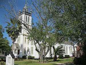 Guardian Angel Catholic Church on Demel Street
 -
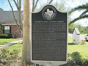 Historical marker at Guardian Angel Catholic Church
 -
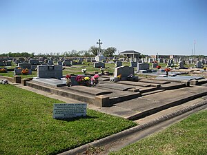 Guardian Angel Cemetery on FM 1952 south of Wallis


Government and infrastructure
[edit]-
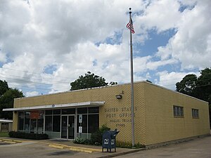 US Post Office on Railroad St near FM 1093
 -
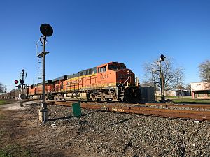 BNSF 6041 pulls an eastbound freight at 2nd Street
 -
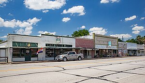 Stores in Wallis, Texas


.jpg)
Demographics
[edit]| Census | Pop. | Note | %± |
|---|---|---|---|
| 1880 | 29 | — | |
| 1980 | 1,138 | — | |
| 1990 | 1,001 | −12.0% | |
| 2000 | 1,172 | 17.1% | |
| 2010 | 1,252 | 6.8% | |
| 2020 | 1,292 | 3.2% | |
| U.S. Decennial Census[8] | |||
| Race | Number | Percentage |
|---|---|---|
| White (NH) | 653 | 50.54% |
| Black or African American (NH) | 156 | 12.07% |
| Native American or Alaska Native (NH) | 4 | 0.31% |
| Asian (NH) | 7 | 0.54% |
| Some Other Race (NH) | 5 | 0.39% |
| Mixed/Multi-Racial (NH) | 44 | 3.41% |
| Hispanic or Latino | 423 | 32.74% |
| Total | 1,292 |
As of the 2020 United States census, there were 1,292 people, 729 households, and 447 families residing in the city.
As of the census[2] of 2000, there were 1,172 people, 422 households, and 314 families residing in the city. The population density was 767.7 inhabitants per square mile (296.4/km2). There were 455 housing units at an average density of 298.0 per square mile (115.1/km2). The racial makeup of the city was 71.50% White, 13.74% African American, 0.43% Native American, 0.09% Pacific Islander, 10.92% from other races, and 3.33% from two or more races. Hispanic or Latino of any race were 23.38% of the population.
There were 422 households, out of which 35.5% had children under the age of 18 living with them, 58.8% were married couples living together, 11.8% had a female householder with no husband present, and 25.4% were non-families. 21.3% of all households were made up of individuals, and 12.1% had someone living alone who was 65 years of age or older. The average household size was 2.77 and the average family size was 3.23.
In the city, the population was spread out, with 28.1% under the age of 18, 9.2% from 18 to 24, 27.6% from 25 to 44, 21.8% from 45 to 64, and 13.2% who were 65 years of age or older. The median age was 35 years. For every 100 females, there were 95.7 males. For every 100 females age 18 and over, there were 84.5 males.
The median income for a household in the city was $36,328, and the median income for a family was $40,000. Males had a median income of $30,481 versus $20,664 for females. The per capita income for the city was $16,877. About 6.4% of families and 10.8% of the population were below the poverty line, including 13.3% of those under age 18 and 15.6% of those age 65 or over.
The current mayor of Wallis is Jerry Delso, elected May 12, 2012, by a vote of 171–57 over incumbent Carolyn Kennedy.
Education
[edit]Wallis is served by the Brazos Independent School District (formerly Wallis-Orchard Independent School District) and home to the Brazos High School Cougars.
The designated community college for Brazos ISD is Wharton County Junior College (the legislation still states "Wallis-Orchard").[12]
-
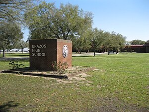 Brazos High School on Hwy. 36 in Wallis
 -
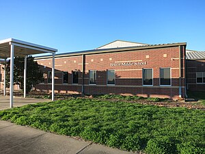 Brazos Middle School behind H.S. in Wallis
 -
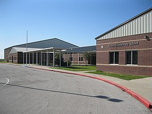 Brazos Elementary School in Orchard


Media
[edit]Wallis is one of the key towns featured in the 2009 documentary The Heart of Texas.[13]
The opening scene of the movie Urban Cowboy was filmed at a farm just outside Wallis on FM 1952.
See also
[edit]References
[edit]- ^ "2019 U.S. Gazetteer Files". United States Census Bureau. Retrieved August 7, 2020.
- ^ a b "U.S. Census website". United States Census Bureau. Retrieved January 31, 2008.
- ^ "US Board on Geographic Names". United States Geological Survey. October 25, 2007. Retrieved January 31, 2008.
- ^ a b "Geographic Identifiers: 2010 Demographic Profile Data (G001): Wallis city, Texas". U.S. Census Bureau, American Factfinder. Archived from the original on February 10, 2020. Retrieved August 26, 2013.
- ^ "US Gazetteer files: 2010, 2000, and 1990". United States Census Bureau. February 12, 2011. Retrieved April 23, 2011.
- ^ Jackson, Charles Christopher. "Handbook of Texas Online: WALLIS, TX". Texas State Historical Association. Retrieved June 2, 2013.
- ^ "Wallis, Texas" (Map). Google Maps. Google. June 2, 2013. Retrieved June 2, 2013.
- ^ "Census of Population and Housing". Census.gov. Retrieved June 4, 2015.
- ^ "Explore Census Data". data.census.gov. Retrieved May 25, 2022.
- ^ https://www.census.gov/ [not specific enough to verify]
- ^ "About the Hispanic Population and its Origin". www.census.gov. Retrieved May 18, 2022.
- ^ Texas Education Code Sec. 130.211. WHARTON COUNTY JUNIOR COLLEGE DISTRICT SERVICE AREA.
- ^ 2009 Documentary about events in Wallis, TX. The Heart of Texas
External links
[edit]Municipalities and communities of Austin County, Texas, United States | ||
|---|---|---|
| Cities |  | |
| Towns | ||
| Other communities | ||
| Ghost town | ||
| Footnotes | ‡This populated place also has portions in an adjacent county or counties | |