„Chassignieu“ – Versionsunterschied
Zur Navigation springen
Zur Suche springen
| [gesichtete Version] | [gesichtete Version] |
Inhalt gelöscht Inhalt hinzugefügt
→Einleitung: Intercomm korr. |
KKeine Bearbeitungszusammenfassung |
||
| Zeile 13: | Zeile 13: | ||
|longitude=05/30/19/O |
|longitude=05/30/19/O |
||
|latitude=45/30/04/N |
|latitude=45/30/04/N |
||
|km²=5.17 |
|||
|siteweb= |
|siteweb= |
||
|image=Mairie_Chassignieu_abc1.jpg |
|image=Mairie_Chassignieu_abc1.jpg |
||
| Zeile 25: | Zeile 24: | ||
== Bevölkerungsentwicklung == |
== Bevölkerungsentwicklung == |
||
{| class="wikitable" style=" |
{| class="wikitable" style="width:400px; text-align:center;" |
||
! style="background: #F5F5F5; width:11%; color:#000000;" | 1962 |
|||
! style="background: #F5F5F5; width:11%; color:#000000;" | 1968 |
|||
! style="background: #F5F5F5; width:11%; color:#000000;" | 1975 |
|||
! style="background: #F5F5F5; width:11%; color:#000000;" | 1982 |
|||
! style="background: #F5F5F5; width:11%; color:#000000;" | 1990 |
|||
! style="background: #F5F5F5; width:11%; color:#000000;" | 1999 |
|||
! style="background: #F5F5F5; width:11%; color:#000000;" | 2006 |
|||
! style="background: #F5F5F5; width:11%; color:#000000;" | 2013 |
|||
|- |
|- |
||
! style="text-align:left;"| Jahr || 1962 || 1968 || 1975 || 1982 || 1990 || 1999 || 2006 || 2012 |
|||
| style="background: #D1E8FF; color:#000000;" | 252 |
|||
| style="background: #D1E8FF; color:#000000;" | 239 |
|||
| style="background: #D1E8FF; color:#000000;" | 198 |
|||
| style="background: #D1E8FF; color:#000000;" | 190 |
|||
| style="background: #D1E8FF; color:#000000;" | 188 |
|||
| style="background: #D1E8FF; color:#000000;" | 192 |
|||
| style="background: #D1E8FF; color:#000000;" | 202 |
|||
| style="background: #D1E8FF; color:#000000;" | 208 |
|||
|- |
|- |
||
|style="text-align:left;"| '''Einwohner''' || 252 || 239 || 198 || 190 || 188 || 192 || 202 || 208 |
|||
| ⚫ | |||
|- |
|||
| ⚫ | |||
|} |
|} |
||
Version vom 31. Januar 2021, 12:25 Uhr
| Chassignieu | ||
|---|---|---|
| ||
| Staat | Frankreich | |
| Region | Auvergne-Rhône-Alpes | |
| Département (Nr.) | Isère (38) | |
| Arrondissement | La Tour-du-Pin | |
| Kanton | Le Grand-Lemps | |
| Gemeindeverband | Les Vals du Dauphiné | |
| Koordinaten | 45° 30′ N, 5° 30′ O | |
| Höhe | 373–607 m | |
| Fläche | 5,17 km² | |
| Einwohner | 223 (1. Januar 2021) | |
| Bevölkerungsdichte | 43 Einw./km² | |
| Postleitzahl | 38730 | |
| INSEE-Code | 38089 | |
 Rathaus (Mairie) von Chassignieu | ||

Chassignieu ist eine französische Gemeinde mit 223 Einwohnern (Stand: 1. Januar 2021) im Département Isère in der Region Auvergne-Rhône-Alpes; sie gehört administrativ zum Arrondissement La Tour-du-Pin und ist Teil des Kantons Le Grand-Lemps (bis 2015: Kanton Virieu).
Geografie
Chassignieu befindet sich etwa 60 Kilometer ostsüdöstlich von Lyon. Der Bourbre begrenzt die Gemeinde im Nordwesten. Umgeben wird Chassignieu von den Nachbargemeinden Le Passage im Norden, Valencogne im Süden und Osten sowie Chélieu im Westen und Nordwesten.
Bevölkerungsentwicklung
| Jahr | 1962 | 1968 | 1975 | 1982 | 1990 | 1999 | 2006 | 2012 |
|---|---|---|---|---|---|---|---|---|
| Einwohner | 252 | 239 | 198 | 190 | 188 | 192 | 202 | 208 |
| Quellen: Cassini und INSEE | ||||||||
Sehenswürdigkeiten
- Kirche Notre-Dame-de-l'Assomption, 1894 erbaut
- Schloss Bellegarde, seit 1996 Monument historique
-
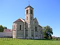 Kirche Notre-Dame-de-l'Assomption
 -
 Schloss Bellegarde


Weblinks
Commons: Chassignieu – Sammlung von Bildern, Videos und Audiodateien